- Outline of Canada
-
 The National Flag of Canada
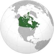
 An enlargeable map of Canada, showing its ten provinces and three territories.See also: Index of Canada-related articles and List of Canada-related topics by provinces and territories
Canada (
 /ˈkænədə/) is a North American country consisting of ten provinces and three territories. Located in the northern part of the continent, it extends from the Atlantic Ocean in the east to the Pacific Ocean in the west and northward into the Arctic Ocean.[1] It is the world's second largest country by total area, and shares land borders with the United States to the south and northwest, and marine borders with France and Greenland on the east and northeast, respectively.
The lands have been inhabited for millennia by various groups of aboriginal peoples. Beginning in the late 15th century, British and French expeditions explored and later settled the Atlantic coast. France ceded nearly all of its colonies in North America in 1763 after the Seven Years War. In 1867, with the union of three British North American colonies through Confederation, Canada was formed as a federal dominion of four provinces.[2][3][4] This began an accretion of additional provinces and territories and a process of increasing autonomy from the United Kingdom, highlighted by the Statute of Westminster in 1931 and culminating in the Canada Act in 1982 which severed the vestiges of legal dependence on the British parliament.
Canada is a federation that is governed as a parliamentary democracy and a constitutional monarchy with Queen Elizabeth II as its head of state. It is a bilingual and multicultural country, with both English and French as official languages at the federal level. Technologically advanced and industrialized, Canada maintains a diversified economy that is heavily reliant upon its abundant natural resources and upon trade—particularly with the United States, with which Canada has a long and complex relationship.
The following outline is provided as an overview of and topical guide to Canada:
General reference
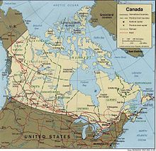 An enlargeable map of Canada
- Pronunciation /ˈkænədə/
- Common English country name: Canada
- Official English country name: Canada
- Common endonym: Canada
- Official endonym: Canada
- Adjectival: Canadian, Canada
- Demonym: Canadian (Fr. canadien)
- Etymology: Name of Canada
- ISO country codes: CA, CAN, 124
- ISO region codes: See ISO 3166-2:CA
- Internet country code top-level domain: .ca
- International rankings of Canada
Geography of Canada
Main article: Geography of Canada- Canada is...
- Location:
- Northern Hemisphere, Western Hemisphere
- Time zones (Time in Canada):
- Newfoundland Standard Time (UTC-03:30), Newfoundland Daylight Time (UTC-02:30)
- Atlantic Standard Time (UTC-04), Atlantic Daylight Time (UTC-03)
- Eastern Standard Time (UTC-05), Eastern Daylight Time (UTC-04)
- Central Standard Time (UTC-06), Central Daylight Time (UTC-05)
- Mountain Standard Time (UTC-07), Mountain Daylight Time (UTC-06)
- Pacific Standard Time (UTC-08), Pacific Daylight Time (UTC-07)
- Extreme points of Canada
- North: Cape Columbia, Nunavut - (83°08' N, 74°13'W)
- South: Middle Island, Ontario - (41°41'N, 82°40'W)
- East: Cape Spear, Newfoundland - (47°31'N, 52°37'W)
- West: Yukon-Alaska border - (141°00'W)
- High: Mount Logan 5,959 m (19,551 ft)
- Low: North Atlantic Ocean, Arctic Ocean, and North Pacific Ocean 0 m
- Land boundaries:
 United States 8,893 km[5]
 - Coastline: 202,080 km[6]
- Population of Canada: 33,338,000 people (2008 estimate) - 36th most populous country
- Area of Canada: 9,984,670 km² (3,854,085 sq mi) - 2nd most extensive country
- Atlas of Canada
Environment of Canada
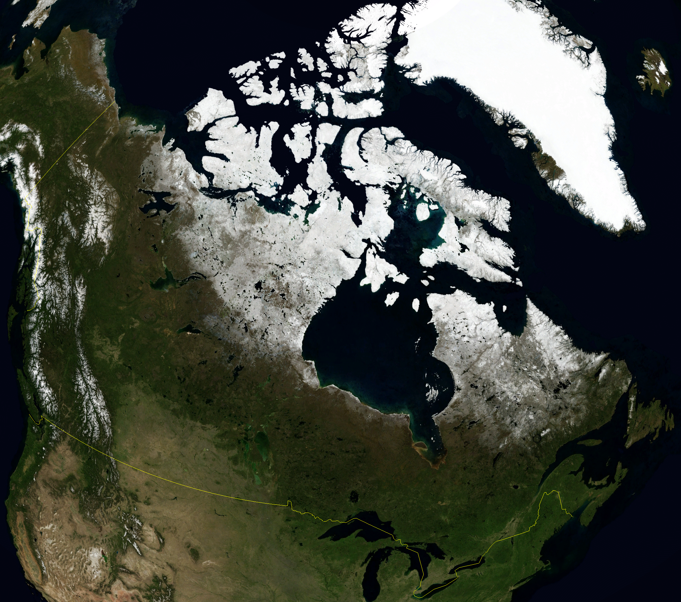
 An enlargeable satellite image of CanadaMain article: Environment of Canada
- Climate of Canada
- Environmental issues in Canada
- Fires in Canada
- Ecoregions in Canada
- Renewable energy in Canada
- Geology of Canada
- National parks of Canada
- Protected areas of Canada
- Wildlife of Canada
Geographic features of Canada
Main article: Landforms of Canada- Canadian Arctic
- Fjords of Canada
- Glaciers of Canada
- Islands of Canada
- Lakes of Canada
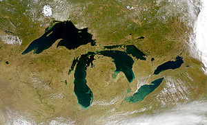 A satellite image of the Great Lakes.
- Mountain peaks of Canada
- The 100 Highest mountain peaks of Canada
- The 142 Most prominent mountain peaks of Canada
- The 100 Most isolated mountain peaks of Canada
- Appalachian Mountains
- Pacific Cordillera
- Rocky Mountains
- Volcanoes of Canada
- Prairies of Canada
- Rivers of Canada
- Waterfalls of Canada
- Valleys of Canada
- World Heritage Sites in Canada
- Other
- Canadian Shield
- St. Lawrence Lowlands
- List of National Historic Sites of Canada
Regions of Canada
- Main article: Regions of Canada
- Northern Canada (The North)
- Western Canada
- Eastern Canada
Other regions
- English Canada, sometimes known as the Rest of Canada (excluding Quebec) when considering topics of language
- French Canada
- Acadia
- Quebec-Windsor Corridor
Ecoregions of Canada
- Main article: Ecoregions of Canada
Administrative divisions of Canada
Main article: Provinces and territories of CanadaProvinces
Province, with flag Postal abbreviation/
ISO codeOther abbreviations Capital Entered Confederation Population
(2007)[7]Area (km²) Land Water Total  Ontario1
ON Ont. Toronto July 1, 1867 12,753,702 917,741 158,654 1,076,395  Quebec1
QC Que., PQ, P.Q. Quebec City 7,687,068 1,356,128 185,928 1,542,056  Nova Scotia2
NS N.S. Halifax 932,966 53,338 1,946 55,284  New Brunswick2
NB N.B. Fredericton 748,878 71,450 1,458 72,908  Manitoba3
MB Man. Winnipeg July 15, 1870 1,182,921 553,556 94,241 647,797  British Columbia2
BC B.C. Victoria July 20, 1871 4,352,798 925,186 19,549 944,735  Prince Edward Island2
PE PEI, P.E.I., P.E. Island Charlottetown July 1, 1873 138,800 5,660 — 5,660  Saskatchewan4
SK Sask., SK, SKWN Regina September 1, 1905 990,212 591,670 59,366 651,036  Alberta4
AB Alta. Edmonton 3,455,062 642,317 19,531 661,848  Newfoundland and Labrador5
NL Nfld., NF, LB St. John's March 31, 1949 506,548 373,872 31,340 405,212 Notes:
- Immediately prior to Confederation, Ontario and Quebec were part of the Province of Canada.
- Nova Scotia, New Brunswick, British Columbia, and Prince Edward Island were separate colonies at the time of joining Canada.
- Manitoba was established simultaneously with Northwest Territories.
- Saskatchewan and Alberta were created out of land that had been part of Northwest Territories.
- Prior to its entry, Newfoundland was a Dominion within the British Commonwealth.
Territories
There are currently three territories in Canada. Unlike the provinces, the territories of Canada have no inherent jurisdiction and only have those powers delegated to them by the federal government.
Territory, with flag Postal abbreviation/
ISO codeOther abbreviations Capital Entered Confederation Population
(2007)Area (km²) Land Water Total  Northwest Territories
NT N.W.T., NWT Yellowknife July 15, 1870 41,795 1,183,085 163,021 1,346,106  Yukon
YukonYT Y.T., YK Whitehorse June 13, 1898 30,883 474,391 8,052 482,443  Nunavut
NU NV Iqaluit April 1, 1999 31,216 1,936,113 157,077 2,093,190 Note: Canada did not acquire any new land to create Yukon, Alberta, Saskatchewan, or Nunavut. All of these originally formed part of Northwest Territories.
Municipalities of Canada
Main article: Municipalities of Canada- Cities of Canada
- Capital of Canada: Ottawa
Demography of Canada
Main article: Demography of CanadaDemographics by political division
Provinces
Territories
Government and politics of Canada
Canada 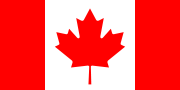
This article is part of the series:
Politics and government of
CanadaParliamentary constituencies
Electoral system
Last election (2011)Canadian federalism
Monarchy in the Canadian provinces- Lieutenant Governors
Executive Councils
Politics of the Canadian provinces
Municipal government in CanadaGeneralRegions
Political culture
Foreign relations
Office-holders of Canada
Political movements
Other countries · Atlas
Politics of Canada portal
- Main article: Government of Canada and Politics of Canada
- Form of government: constitutional monarchy and democratic parliamentary federation
- Capital of Canada: Ottawa
- Administrative divisions of Canada
- Canadian and American politics compared
- Canadian and Australian politics compared
- Canadian Conservatism
- List of Canadian federal general elections
- Canadian Nationalism
- Elections in Canada
- Electoral ridings
- Electoral system
- List of elections
- Federalism in Canada
- Human rights in Canada
- Liberalism in Canada
- Political culture of Canada
- Political parties in Canada
- Political scandals of Canada
- Progressivism in Canada
- Socialism and Social Democracy in Canada
- Taxation in Canada
Branches of the government of Canada
Main article: Government of CanadaExecutive branch of the government of Canada
Monarchy of Canada 
This article is part of a series Canadian monarchical history
Canadian monarchs & consorts
Monarchy by provinces
BC AB SK MB ON
QC NB NS PE NLCanadian royal symbols
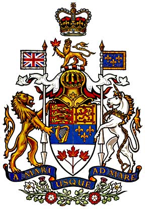
Royal Arms of Canada
Royal monuments
Great Seal of Canada
Royal eponyms
Royal prefix
Royal patronage
Royal stamps
Royal SwansLegislative branch of the government of Canada
Judicial branch of the government of Canada
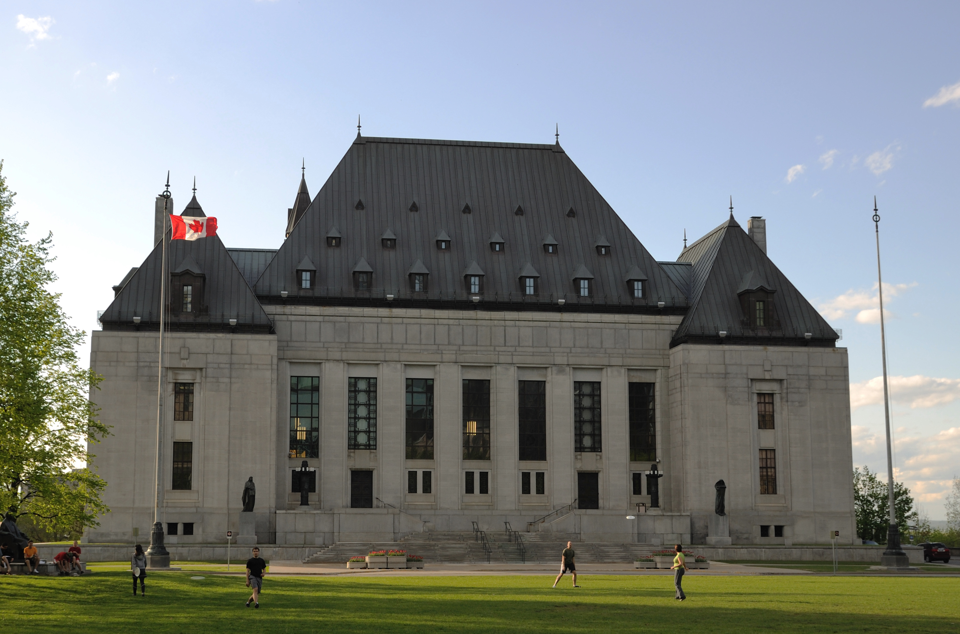
Main article: Court system of Canada Supreme Court
of Canada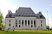
History · Act · Process Current members Beverley McLachlin (Chief Justice)
Louis LeBel · Marie Deschamps
Morris Fish · Rosalie Abella
Marshall Rothstein · Thomas Cromwell
Michael Moldaver · Andromache KarakatsanisAll members Past Chief Justices
Past Puisne Justices
by Court composition
by time in officeJudgments - Supreme Court of Canada
- Appellate Courts of the provinces and territories
- Alberta Court of Appeal
- British Columbia Court of Appeal
- Manitoba Court of Appeal
- New Brunswick Court of Appeal
- Supreme Court of Newfoundland (Court of Appeal)
- Court of Appeal for the Northwest Territories
- Nova Scotia Court of Appeal
- Nunavut Court of Appeal
- Court of Appeal for Ontario
- Supreme Court of Prince Edward Island - Appeal Division
- Quebec Court of Appeal
- Saskatchewan Court of Appeal
- Court of Appeal of the Yukon Territory
- Superior-level courts of the provinces and territories
- Court of Queen's Bench of Alberta
- Supreme Court of British Columbia
- Court of Queen's Bench of Manitoba
- Court of Queen's Bench of New Brunswick
- Supreme Court of Newfoundland and Labrador (Trial Division)
- Supreme Court of the Northwest Territories
- Supreme Court of Nova Scotia
- Nunavut Court of Justice
- Ontario Superior Court of Justice
- Supreme Court of Prince Edward Island - Trial Division
- Quebec Superior Court
- Court of Queen's Bench for Saskatchewan
- Supreme Court of the Yukon Territory
Foreign relations of Canada
Main article: Foreign relations of Canada- Canadian Confederation
- Canada–Caribbean relations
- Canada–Jamaica relations
- Canada–Croatia relations
- Canada-Cuba relations
- Canada–Cyprus relations
- Canada–Czech Republic relations
- Canada–Denmark relations
- Canada–Egypt relations
- Canada–Estonia relations
- Canada–Ethiopia relations
- Canada–Finland relations
- Canada–France relations
- Canada–Georgia relations
- Canada–Germany relations
- Greek-Canadian relations
- Canada–Holy See relations
- Canada–Hungary relations
- Canada–Iceland relations
- Canada–India relations
- Canada–Indonesia relations
- Canada–Ireland relations
- Canada–Israel relations
- Canada–Italy relations
- Canada–Japan relations
- Canada–Kazakhstan relations
- Canada–Kenya relations
- Canada–Kosovo relations
- Canada-Latin America relations
- Brazilian–Canadian relations
- Canada–Chile relations
- Canada–Colombia relations
- Canada–Panama relations
- Canada–Paraguay relations
- Canada–Peru relations
- Canada–Uruguay relations
- Canada–Venezuela relations
- Canada–Mexico relations
- Canada–Latvia relations
- Canada–Lebanon relations
- Canada–Lithuania relations
- Canada–Luxembourg relations
- Canada–Malaysia relations
- Canada–Malta relations
- Canada–Mongolia relations
- Canada–Montenegro relations
- Canada–Morocco relations
- Canada–Netherlands relations
- Canada–New Zealand relations
- Canada–Nigeria relations
- Canada–Norway relations
- Canada–Pakistan relations
- Canada–People's Republic of China relations
- Canada–Philippines relations
- Canada–Poland relations
- Canada–Romania relations
- Canada–Russia relations
- Canada–Saudi Arabia relations
- Canada–Serbia relations
- Canada–Singapore relations
- Canada–Slovakia relations
- Canada–Slovenia relations
- Canada–South Korea relations
- Canada–Soviet Union relations
- Canada–Spain relations
- Canada–Sweden relations
- Canada–Switzerland relations
- Canada–Thailand relations
- Canada–Tunisia relations
- Canada–Turkey relations
- Canada–Ukraine relations
- Canada–United Kingdom relations
- Canada – United States relations
- Canada–Vietnam relations
- Canada–Zimbabwe relations
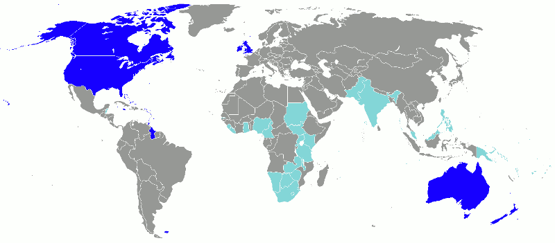
International organization membership
Canada is a member of:[1]
Law and order in Canada
- Main article: Law of Canada
- Canadian Aboriginal law
- Canada Bank Act
- Canadian Bill of Rights
- Canadian competition law
- Constitution of Canada
- Canadian content
- Canadian contract law
- Canadian copyright law
- Canadian corporation
- Crime in Canada
- Canadian family law
- Law enforcement in Canada
- Criminal law statute
- List of law enforcement agencies in Canada
Military of Canada
- Main article: Military of Canada
Military history of Canada

This article is part of a series Conflicts Beaver Wars
French and Indian Wars
American Civil War
War of 1812
Fenian raids
Wolseley Expedition
North-West Rebellion
Boer War
First World War
Russian Civil War
Spanish Civil War
Second World War
Cold War
Korean War
Vietnam War
Gulf War
Afghanistan War
Iraq War
Intervention in LibyaHistory of.. Militia · Crown & Forces
Army · Navy · Air ForceLists Conflicts · Operations
Peacekeeping · BibliographyCanadian Forces portal - Command structure
- Commander-in-chief: Governor General of Canada (nominally, see also The Canadian Crown and the Canadian Forces)
- Prime Minister of Canada (de facto Commander-in-chief)
- Minister of National Defence
- Chief of the Defence Staff
- Maritime Command (MARCOM), command of the Navy;
- Land Force Command (LFC) command of the Army;
- Air Command (AIRCOM), command of the Air Force.
- Canada Command (CANCOM), responsible for all operations within Canada;
- Canadian Expeditionary Force Command (CEFCOM), responsible for operations outside of Canada;
- Canadian Special Operations Forces Command (CANSOFCOM), responsible for special forces operations within Canada and abroad.
- Canadian Operational Support Command (CANOSCOM)
- Chief of the Defence Staff
- Minister of National Defence
- Canadian Forces
Province governments
- Government of Alberta
- Government of British Columbia
- Government of Vancouver (city)
- Government of Manitoba
- Government of New Brunswick
- Government of Newfoundland and Labrador
- Government of Nova Scotia
- Government of Ontario
- Government of Toronto (city)
- Government of Prince Edward Island
- Government of Quebec
- Government of Montreal (city)
- Government of Saskatchewan
Territory governments
Politics by political division
Provinces
Territories
- Politics of Northwest Territories
- Politics of Nunavut
- Politics of the Yukon
History of Canada
- Main article: History of Canada and Timeline of Canadian history
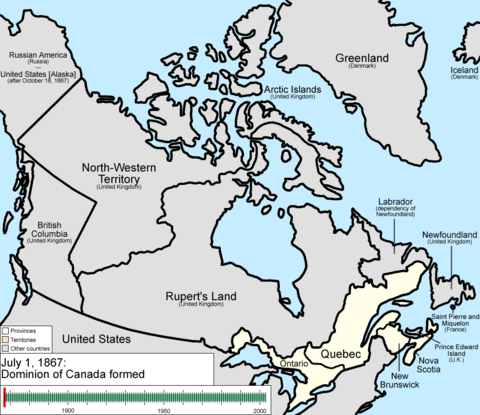 Evolution of the borders and names of Canada's provinces and territories
- Former Colonies and Territories in Canada
- Constitutional history of Canada
- History of immigration to Canada
- Economic history of Canada
- Fires in Canada
- Military history of Canada
- History of monarchy in Canada
- Persons of National Historic Significance
- Territorial evolution of Canada (1867–present)
History of Canada by period
- Pre-Columbian era (Canada)
- 1534–1763: New France
- 1764-1867: Canada under British Imperial Control
- 1867-1914: Post-Confederation Canada
- 1914-1945: Canada in the World Wars and Interwar Years
- 1945-1960
- 1960-1981
- 1982-1992
- 1992-present
History of Canada by political division
Provinces
Territories
- History of Nunavut
- History of the Northwest Territories
- History of the Yukon
Culture of Canada
- Main article: Culture of Canada
- Age and internet use in Canada
- Alcoholic beverages in Canada
- Architecture of Canada
- Cuisine of Canada
- Decorations and medals of Canada (in order of precedence)
- Festivals in Canada
- Humour in Canada
- Languages of Canada
- Media in Canada
- Symbols of Canada
- National symbols of Canada
- Coat of arms of Canada
- Flag of Canada
- National anthem of Canada
- Royal symbols of Canada
- National symbols of Canada
- People of Canada
- Prostitution in Canada
- Public holidays in Canada
- World Heritage Sites in Canada
Culture by political division
Provinces
- Culture of Alberta
- Culture of British Columbia
- Culture of Vancouver (city)
- Culture of Manitoba
- Culture of New Brunswick
- Culture of Nova Scotia
- Culture of Ontario
- Culture of Hamilton, Ontario (city)
- Culture of Toronto (city)
Territories
- Culture of Northwest Territories
- Culture of Nunavut
- Culture of the Yukon
Art in Canada
- Art in Canada
- Cinema of Canada
- Canadian comics
- Literature of Canada
- Television in Canada
- Theatre of Canada
Music of Canada
- Main article: Music of Canada
- Canadian blues
- Canadian classical music
- Canadian hip hop
- Canadian Idol
- Canadian rock
- Caribbean music in Canada
- Music of Canadian cultures
Music by political division
Provinces
- Music of Ontario
- Music of Toronto (city)
- Music of Prince Edward Island
- Music of Quebec
- Music of Montreal (city)
- Music of Saskatchewan
Territories
- Music of Northwest Territories
- Music of Nunavut
- Music of the Yukon
Religion in Canada
- Religion in Canada
- Buddhism in Canada
- Christianity in Canada
- Hinduism in Canada
- Islam in Canada
- Judaism in Canada
- Sikhism in Canada
- Irreligion in Canada
Sport in Canada
- Main article: Sport in Canada
Official Sports
Other sports
Economy and infrastructure of Canada
Main article: Economy of CanadaEconomy of Canada This article is part of a series Economic history of Canada Sectors Primary sector Secondary sector -
- Automotives
Tertiary sector Finance - Central Bank
- Banking in Canada
- Stock exchanges
Companies - Companies listed on the TSX
Economy by Province Alberta – Ontario – Quebec – Saskatchewan - more... Economy by City Montreal – Toronto - Vancouver - more... - Economic rank, by nominal GDP (2007): 9th (ninth)
- Agriculture in Canada
- Banking in Canada
- Communications in Canada
- Companies of Canada
- Currency of Canada: Dollar
- ISO 4217: CAD
- Economic history of Canada
- Energy in Canada
- Geothermal power in Canada
- Health care in Canada
- Mining in Canada
- Science and technology in Canada
- Stock exchanges:
-
- CNQ
- Nasdaq Canada
- Toronto Stock Exchange, S&P/TSX 60 is the main index of TSX
- TSX Venture Exchange
- Winnipeg Commodity Exchange
- Montreal Exchange
- Tourism in Canada
- Transport in Canada
- Water supply and sanitation in Canada
Economics by political division
Provinces
- Economy of Alberta
- Economy of British Columbia
- Economy of Vancouver (city)
- Economy of Manitoba
- Economy of New Brunswick
- Economy of Newfoundland and Labrador
- Economy of Nova Scotia
- Economy of Ontario
- Economy of Toronto (city)
- Economy of Prince Edward Island
- Economy of Quebec
- Economy of Saskatchewan
Territories
- Economy of Northwest Territories
- Economy of Nunavut
- Economy of the Yukon
Education in Canada
- Main article: Education in Canada
- Main article: Higher education in Canada
Higher Education by political division
Provinces
Territories
- Higher education in Northwest Territories
- Higher education in Nunavut
- Higher education in the Yukon
See also
Main article: Canada- All pages beginning with "Canada"
- All pages beginning with "Canadian"
- All pages with titles containing "Canada"
- All pages with titles containing "Canadian"
- Commonwealth realm
- Index of Canada-related articles
- List of international rankings
- Member state of the Commonwealth of Nations
- Member state of the Group of Twenty Finance Ministers and Central Bank Governors
- Member state of the North Atlantic Treaty Organization
- Member state of the United Nations
- Monarchy of Canada
- Outline of geography
- Outline of North America
References
- ^ a b "Canada". The World Factbook. United States Central Intelligence Agency. July 8, 2009. https://www.cia.gov/library/publications/the-world-factbook/geos/ca.html. Retrieved July 23, 2009.
- ^ "Territorial evolution". Atlas of Canada. Natural Resources Canada. http://atlas.nrcan.gc.ca/site/english/maps/reference/anniversary_maps/terr_evol. Retrieved 2007-10-09. "In 1867, the colonies of Canada, Nova Scotia and New Brunswick are united in a federal state, the Dominion of Canada...."
- ^ "Canada: History". Country Profiles. Commonwealth Secretariat. http://www.thecommonwealth.org/YearbookInternal/145152/history/. Retrieved 2007-10-09. "The British North America Act of 1867 brought together four British colonies ... in one federal Dominion under the name of Canada."
- ^ Hillmer, Norman; W. David MacIntyre. "Commonwealth". Canadian Encyclopedia. Historica Project. http://thecanadianencyclopedia.com/index.cfm?PgNm=TCE&Params=A1ARTA0001798. Retrieved 2007-10-09. "With CONFEDERATION in 1867, Canada became the first federation in the British Empire ..."
- ^ The total length of the land border between Canada and the United States is the longest between any two countries.
- ^ The coastline of Canada is the longest in the world. The total length of the coast of Canada is more than five times as long as the circumference of the Earth.
- ^ Statistics Canada Population Estimates (April 1, 2007)
Further reading
Main article: Bibliography of Canada- Blore, Shawn (2004), Frommer's Canada, Wiley Pub, ISBN 0764544691, http://books.google.ca/books?id=EqKBRG7ICeAC&lpg=PP1&dq=Canada&pg=PP1#v=onepage&q&f=true
- Jepson, Tim (2004), The rough guide to Canada, Rough Guides, ISBN 1843532662, http://books.google.ca/books?id=gfL3uuJTPygC&lpg=PP1&dq=Canada&pg=PP1#v=onepage&q&f=true
- Kearney, Mark; Randy Ray (2009), The Big Book of Canadian Trivia, Dundurn Press, ISBN 9781554884179, http://books.google.ca/books?id=RoBytz0-XuQC&lpg=PP1&dq=The%20Big%20Book%20of%20Canadian%20Trivia&pg=PP1#v=onepage&q&f=true
- Magocsi, Paul R (1999). Encyclopedia of Canada's peoples. Society of Ontario, University of Toronto Press. ISBN 0802029388. http://books.google.ca/books?id=dbUuX0mnvQMC&lpg=PA582&dq=Territorial%20evolution%20of%20Canada&pg=PP1#v=onepage&q&f=true.
- Moore, Christopher; Slavin, Bill. Janet Lunn (2002), The Big Book of Canada: Exploring the Provinces and Territories, Tundra Books, ISBN 0887764576, http://books.google.ca/books?id=0Dmi_sb_ufgC&lpg=PA1&dq=Provinces%20and%20territories%20of%20Canada&pg=PA1#v=onepage&q&f=true
- Rayburn, Alan (2001). Naming Canada: Stories of Canadian Place Names (2nd ed.). Toronto: University of Toronto Press. ISBN 0-8020-8293-9. http://books.google.ca/books?id=aiUZMOypNB4C&printsec=frontcover&dq=Naming+Canada:+Stories+of+Canadian+Place+Names&hl=en&ei=e1kvTYKOA8SBlAfct6nQCw&sa=X&oi=book_result&ct=result&resnum=1&ved=0CCwQ6AEwAA#v=onepage&q&f=true.
- Zimmerman, Karla (2005), Canada, Lonely Planet Publications, ISBN 9781741045710, http://books.google.ca/books?id=kv4nlSWLT8UC&lpg=PA587&dq=Canada&pg=PA13#v=onepage&q&f=true
External links
- Government
- Official website of the Government of Canada
- Official website of the Prime Minister of Canada
- Official website of the Governor General of Canada
- Official website of the Canadian Forces
- Official Government of Canada online Atlas of Canada
- Permanent Mission of Canada to the United Nations
- Crown corporations
- Other
- Culture.ca — Canada's Cultural Gateway
- Culturescope.ca — Canadian Cultural Observatory
- Canadian Studies: A Guide to the Sources
- Statistics Canada with Canada's population clock
- The Canadian Atlas Online
- Canada entry at The World Factbook
- UN Human Development Program: Country Fact Sheet: Canada, Statistics — Country Sheet: Canada
- Canada travel guide from Wikitravel
- Canada from The Canadian Encyclopedia
Categories:- Canada
- Canada-related lists
- Outlines of countries


Wikimedia Foundation. 2010.