- Bechuanaland Protectorate
Infobox Former Country
native_name =
conventional_long_name = Bechuanaland Protectorate
common_name = Bechuanaland|
continent = Africa
region = Southern Africa
country = Botswana
era = New Imperialism
status = Protectorate
empire = United Kingdom
government_type = Constitutional monarchy
year_start = 1885
year_end = 1966|
event_start = Protectorate established
date_start = March 31
event_end = Independence
date_end = September 30
event1 = Expanded
date_event1 = 1890|
p1 = United States of Stellaland
flag_p1 = Flag of Stellaland (1883-5).svg
s1 = Botswana
flag_s1 = Flag of Botswana.svg|
public seal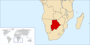
|
capital = Mafeking (1885-1965)Gaborone (1965)
national_anthem = God Save the Queen
common_languages = English
religion =
currency =South African Rand (1961-)|
leader1 = Victoria (first)
year_leader1 = 1885-1901
leader2 = Elizabeth II (last)
year_leader2 = 1952-1966
title_leader = Monarch
title_representative =High Commissioner The Bechuanaland Protectorate (BP) was a protectorate established on
March 31 ,1885 , by theUnited Kingdom insouthern Africa . It became the Republic ofBotswana on30 September 1966 .History
Bechuanaland meant the country of the Bechuana (now written
Batswana orTswana ). The Bechuanaland Protectorate eventually became divided into two. The southern part, south of theMolopo River became thecrown colony known as British Bechuanaland, later became part of theCape Colony and is now inSouth Africa . This is the area aroundMafikeng (then spelled "Mafeking"). The Bechuanaland Protectorate (1904: Area (estimated), 225,000 square miles, population 120,776) formed the northern part; its territory was expanded north in 1890.In 1882 British Bechuanaland (1904: Area, 51,424 square miles, population 84,210) [http://www.1911encyclopedia.org/Bechuanaland] suffered two short term secessions by the
Boer states ofStellaland andGoshen , although both were brought back to British control with a few years. In 1891 the South African Customs Union was extended to British Bechuanaland, and in 1895 the country was annexed to the Cape Colony. [http://www.1911encyclopedia.org/Bechuanaland]The
British government originally expected to turn over administration of the protectorate toRhodesia or South Africa, but Tswana opposition left the protectorate under British rule until Independence in 1966.The BP was technically a
protectorate rather than acolony . Originally the local Tswana rulers were left in power, and the British administration was limited to a police force to protect Bechuanaland's borders against other European colonial ventures. But on9 May 1891 the British Government gave the administration of the protectorate to theHigh Commissioner for South Africa ,who started to appoint officials in Bechuanaland, and the "de facto " independence of Bechuanaland ended.The protectorate was administered from Mafeking, creating a unique situation of the capital of the territory being located outside of it. In 1885, when the protectorate was declared, Bechuanaland was bounded to the north by the latitude of twenty-two degrees south. The northern boundary of the Protectorate was formally extended northward by the British to include
Ngamiland , which was dominated by the Tawana state, on30 June 1890 . [http://www.gov.bw/cgi-bin/news.cgi?d=20020308] This claim was formally recognized byGermany the following day by Article III of theHeligoland-Zanzibar Treaty , which confirmed the western boundary of the British protectorate of Bechuanaland and the German protectorate of South-West Africa and also created theCaprivi strip inherited by modernNamibia : [http://germanhistorydocs.ghi-dc.org/pdf/eng/606_Anglo-German%20Treaty_110.pdf]In Southwest Africa, Germany's sphere of influence is demarcated thus:
# To the south by the line that commences at the mouth of the
Orange River and continues up its northern bank to its intersection point with the 20th degree of eastlongitude .
# To the east by the line that commences at the aforementioned point and follows the 20th degree of east longitude to its intersection point with the 22nd degree of southlatitude . The line then traces this degree of latitude eastward to its intersection with the 21st degree of east longitude, follows this degree of longitude northward to its intersection with the 18th degree of south latitude, runs along this degree of latitude eastward to its intersection with theChobe River . Here it descends thethalweg of the main channel until it meets theZambezi , where it ends. It is understood that under this arrangement Germany shall be granted free access from its protectorate to the Zambezi by means of a strip of land not less than twenty English miles wide at any point. Great Britain's sphere of influence is bounded to the west and northwest by the previously described line and includesLake Ngami .British officials did not arrive in the Ngamiland region until 1894. [http://www.gov.bw/cgi-bin/news.cgi?d=20010907]
The Tati Concessions Land Act of
21 January ,1911 transferred new eastern territory to the Protectoratethe limits of which district are as follows, viz.: From the place where the
This territory was originally claimed byShashe River rises to its junction with the Tati andRamokgwebana River s, thence along the Ramokgwebana River to where it rises and thence along the watershed of those rivers,Matabeleland . In 1887Samuel Edwards working forCecil Rhodes obtained a mining concession, and in 1895 theBritish South Africa Company attempted to acquire the area, but three Tswana chiefs visitedLondon to protest and were successful in fending off the BSAC. This territory forms the modern North-East District of Botswana.The BP was one of the "High Commission Territories", the others being Basutoland (now
Lesotho ) andSwaziland . The official with the authority of agovernor was theHigh Commissioner . This office was first heldby the Governor of theCape Colony , then by theGovernor-General of South Africa , then by British High Commissioners and Ambassadors to South Africa until independence. Consequently, administration was headed in each territory by aResident Commissioner , who thus had approximately the same functions of a Governor but somewhat less authority.Postage stamps
Bechuanaland
postage stamp s were issued from 1888 to 1966.Overprint ed stamps were issued until 1932, when the first stamps inscribed "Bechuanaland Protectorate" were issued. In 1962 the South African rand was introduced, necessitating surcharged stamps until new ones were issued.ee also
*
History of Botswana
*Postage stamps and postal history of Stellaland Republic External links
* [http://www.thuto.org/ubh/bw/bhp1.htm History of Botswana]
* [http://www.thuto.org/ubh/bw/colad/coloff.htm List of colonial officials in the BP]
* [http://www.thuto.org/ubh/bw/botbib.htm Bibliography for Botswana History]References
*
Thomas Tlou andAlec Campbell "History of Botswana"*Neil Parsons "New History of Southern Africa"
*Fred Morton and Jeff Ramsay (eds) "The birth of Botswana : a history of the Bechuanaland Protectorate from 1910 to 1966."


Wikimedia Foundation. 2010.