- Sumatra
Infobox Islands
name = Sumatra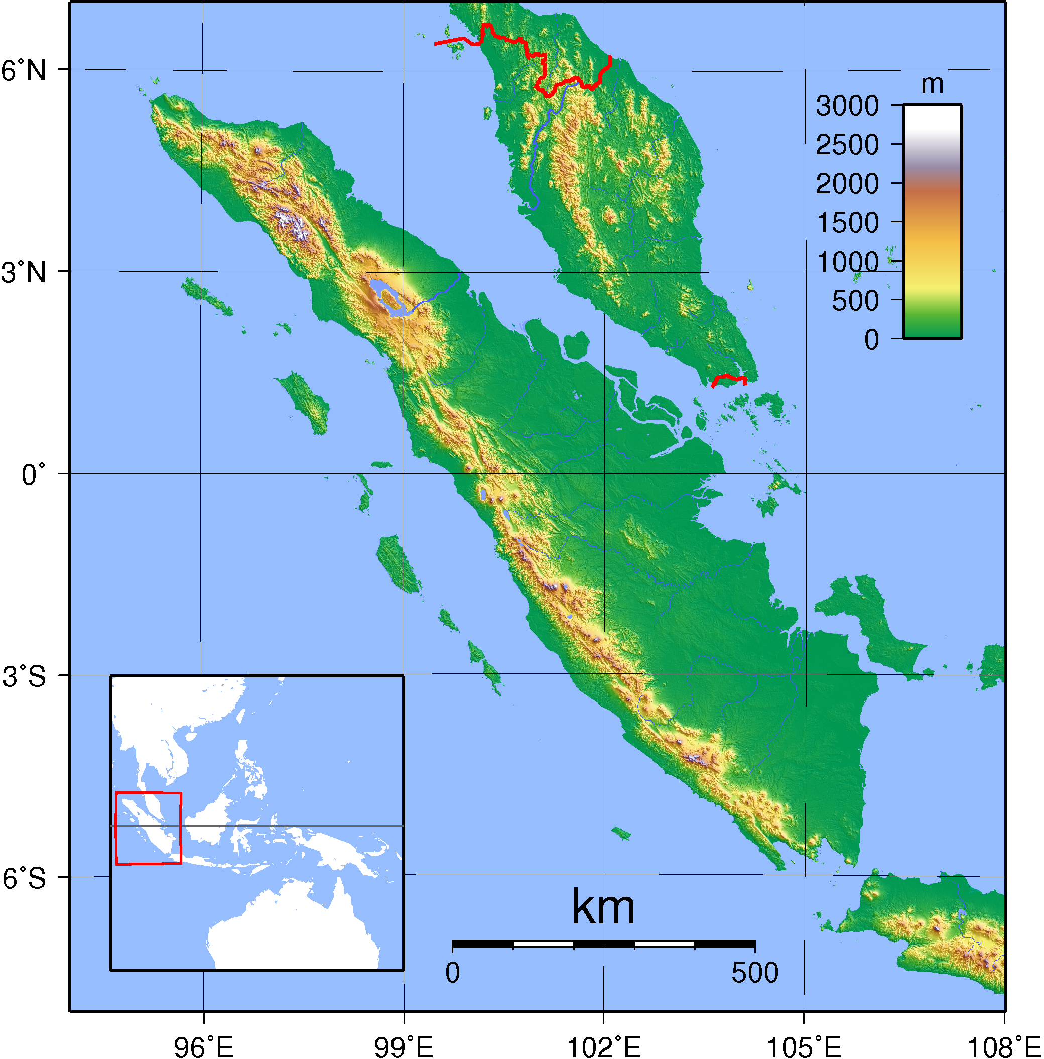
image caption = Topography of Sumatra
locator
native name =
native name link =
location =South East Asia
coordinates = coord|0|00|N|102|00|E|region:ID_type:isle
archipelago =Greater Sunda Islands
area = 470,000 km²
rank = 6th
highest mount = Kerinci
elevation = 3,805 m
country = Indonesia
country admin divisions title = Provinces
country admin divisions =Aceh ,Bengkulu ,Jambi ,Lampung ,Riau ,West Sumatra ,South Sumatra ,North Sumatra
country largest city =Medan
country largest city population = 2,392,922 (as of 2003)
population = 45 million
population as of = 2005
density = 96
ethnic groups =Acehnese , Batak,Minangkabau , MalaySumatra (also spelled Sumatera) is the sixth largest island in the world (approximately 470,000 km²) and is the largest island entirely in
Indonesia (two larger islands,Borneo andNew Guinea , are partially in Indonesia).Etymology
Sumatra was known in ancient times by the
Sanskrit names of "Swarnadwīpa" ("Island of Gold") and "Swarnabhūmi" ("Land of Gold"), due likely to thegold deposits of the island's highlands. [cite book|title=A Kingdom of Words: Language and Power in Sumatra|last=Drakard|first=Jane|publisher=Oxford University Press|date=1999|isbn=983560035X] Arab geographers referred to the island as "Lamri" (Lamuri, Lambri or Ramni) in the 10-13th centuries, in reference to a kingdom near modern dayBanda Aceh which was the first landfall for traders. Late in the 14th century the name Sumatra became popular, in reference to the kingdom of Samudra which was a rising power. European writers in the 19th century found that the indigenous inhabitants did not have a name for the island. [cite book| title=An Indonesian Frontier: Acehnese and Other Histories of Sumatra| last=Reid| first=Anthony| isbn=9971692988| date=2005 |publisher=National University of Singapore Press]History
People who spoke
Austronesian languages first arrived in Sumatra around 500 BCE, as part of theAustronesian expansion from Taiwan to Southeast Asia. With its location in theIndia -China sea trade route, several trading towns flourished, especially in the eastern coast, and were influenced by Indian religions. One of the earliest known kingdoms wasKantoli , which flourished in the 5th century AD in southern Sumatra. Kantoli was replaced by the Empire ofSrivijaya and then later by the Kingdom ofSamudra . Srivijaya was a Buddhist monarchy centered in what is nowPalembang . Dominating the region through trade and conquest throughout the 7th to 9th centuries, the Empire helped spread the Malay culture throughout Sumatra, Malay Peninsula, and western Borneo. The empire was athalassocracy , or maritime power that extended its influence from island to island. Palembang was a center for scholarly learning, and it was there the Chinese Buddhist pilgrim I Ching studied Sanskrit in 671 CE before departing for India. On his journey to China he spent four years in Palembang translating Buddhist texts and writing two manuscripts.Srivijayan influence waned in the 11th century after it was defeated by the
Chola Empire of southern India. Sumatra was then subject to conquests fromJava nese kingdoms, firstSinghasari and subsequentlyMajapahit . At the same time Islam made its way to Sumatra, spreading through contacts with Arabs and Indian traders.By the late 13th century, the monarch of the Samudra kingdom had converted to Islam.
Marco Polo visited the island in 1292 andIbn Battuta visited twice during 1345-1346. Samudra was succeeded by the powerfulAceh Sultanate , which survived to the 20th century. With the coming of the Dutch, the many Sumatran princely states gradually fell under their control. Aceh, in the north, was the major obstacle, as the Dutch were involved in the long and costlyAceh War (1870-1905).On
December 26 2004 , the western coast and islands of Sumatra, particularlyAceh province, were devastated by a nearly 15 meter hightsunami following the 9.2-magnitude Indian Ocean earthquake. The death toll surpassed 170,000 in Indonesia alone, primarily in Aceh.In 2005 there was an 8.7 magnitude aftershock of the previous earthquake in December 2004. See
2005 Sumatran Earthquake . In addition to thesubduction megathrust earthquake off the west coast, Sunda arc, the Great Sumatran Fault, atransform fault , runs the entire length of the island. The pressure on this fault increased dramatically after the December 2004 earthquake, and seismologists are afraid anearthquake is going to occur soon. The fault ends directly below the devastated city ofBanda Aceh .Administration
The administrative regions of Sumatra (or the smaller islands nearby) are:
*Aceh - capital:Banda Aceh
*Bangka-Belitung - capital:Pangkalpinang
*Bengkulu - capital: Bengkulu
*Jambi - capital: Jambi
*Lampung - capital:Bandar Lampung
*Riau - capital:Pekanbaru
*Riau Islands - capital:Tanjung Pinang
*West Sumatra (Sumatera Barat) - capital: Padang
*South Sumatra (Sumatera Selatan) - capital:Palembang
*North Sumatra (Sumatera Utara) - capital: MedanGeography
The longest axis of the
island runs approximately 1,790 km (1,100 miles) northwest - southeast, crossing theequator near the center. At its widest point the island spans 435 km (270 miles). The interior of the island is dominated by two geographical regions: theBarisan Mountains in the west and swampy plains in the east.To the southeast is Java, separated by the
Sunda Strait . To the north is theMalay Peninsula , separated by theStraits of Malacca . To the east isBorneo , across theKarimata Strait . West of the island is theIndian Ocean .The backbone of the island is the Barisan mountains chain, with the active volcano
Mount Kerinci 's 3,805 m (12,467 ft) the highest point, located at about the midpoint of the range. The volcanic activity of this region endowed the region with fertile land and beautiful sceneries, for instance around theLake Toba . It also contains deposits of coal and gold.To the east, big rivers carry silt from the mountain, forming the vast lowland interspersed by swamps. Even if mostly unsuitable for farming, the area is currently of great economic importance for Indonesia. It produces
oil from both above and below the soil—palm oil andpetroleum .Sumatra is the largest producer of
Indonesian coffee . Small-holders grow Arabica coffee (Coffea arabica ) in the highlands, while Robusta (Coffea canephora ) is found in the low lands. Arabica coffee from the regions of Gayo, Lintong and Sidikilang is typically processed using theGiling Basah (wet hulling) technique, which gives it a heavy body and low acidity. [Specialty Coffee Association of Indonesia (2008): [http://www.sca-indo.org/arabica-regions/index.cfm?rid=1] , Retrieved2008-08-08 ]Most of Sumatra used to be covered by
tropical rainforest , but economic development coupled with corruption and illegal logging has severely threatened its existence. Conservation areas have not been spared from destruction, either.The island is the world's 5th highest island, although only the third highest in the Indonesian archipelago.
Flora and fauna
Sumatra supports a wide range of vegetation types which are home to a rich variety of species, including 17 endemic genera of plants.cite book |title=The Ecology of Sumatra |author=Whitten, Tony|date=1999|publisher=Tuttle Publishing|isbn=9625930744] Unique species include:
Sumatran Pine ,Rafflesia arnoldii (world's largest individual flower),Titan arum (world's tallest and largestinflorescence flower).The island is home to 201 mammal species and 580 bird species. There are 9 endemic mammal species on mainland Sumatra and 14 more endemic to the nearby
Mentawai Islands . The species present include:Sumatran Tiger ,Sumatran Orangutan ,Sumatran Rhinoceros ,Sumatran Elephant ,Sumatran Striped Rabbit ,Dhole ,Dayak Fruit Bat ,Malayan Tapir , MalayanSun Bear and theBornean Clouded Leopard .The major threats to Sumatran forest are the
pulp and paper industry and expansion ofpalm oil plantations.The island includes more than 10 National Parks, including 3 which are listed as the "
Tropical Rainforest Heritage of Sumatra "World Heritage Site —Gunung Leuser National Park ,Kerinci Seblat National Park andBukit Barisan Selatan National Park .Demographics
Sumatra is not very densely populated, about 96 people per km²—more than 45 million people in total. It is nonetheless the fifth most populous island in the world. The most populous regions include most of North Sumatra and central highlands in West Sumatra, while the major urban centers are Medan and Palembang.
The people composed of many different ethnic groups, speaking 52 different languages. Most of these groups, however, share many similar traditions and the different tongues are closely related. Malay-speaking people dominate the eastern coast, while people in the southern and central interior speak languages related to Malay, such as the Lampung and
Minangkabau people. The highland of northern Sumatra is inhabited by the Bataks, while the northernmost coast is dominated byAcehs . Ethnic Chinese minorities are also present in urban centers.A majority of people in Sumatra are
Muslim s (87%), while 10% areChristians , 2% areBuddhist and 1%Hindu . [cite web |title=Number of Population by Religion Year 2005 |url=http://www.depag.go.id/index.php?menu=page&pageid=17] Most central Bataks are Protestant Christians—a religion introduced byLudwig Ingwer Nommensen , a German.ee also
*
Music of Sumatra References
External links
*wikitravel
* [http://www.gutenberg.org/etext/16768 William Marsden, "The History of Sumatra," (1783); 3rd ed. (1811) on line.]
Wikimedia Foundation. 2010.