- Coast Mountains
-
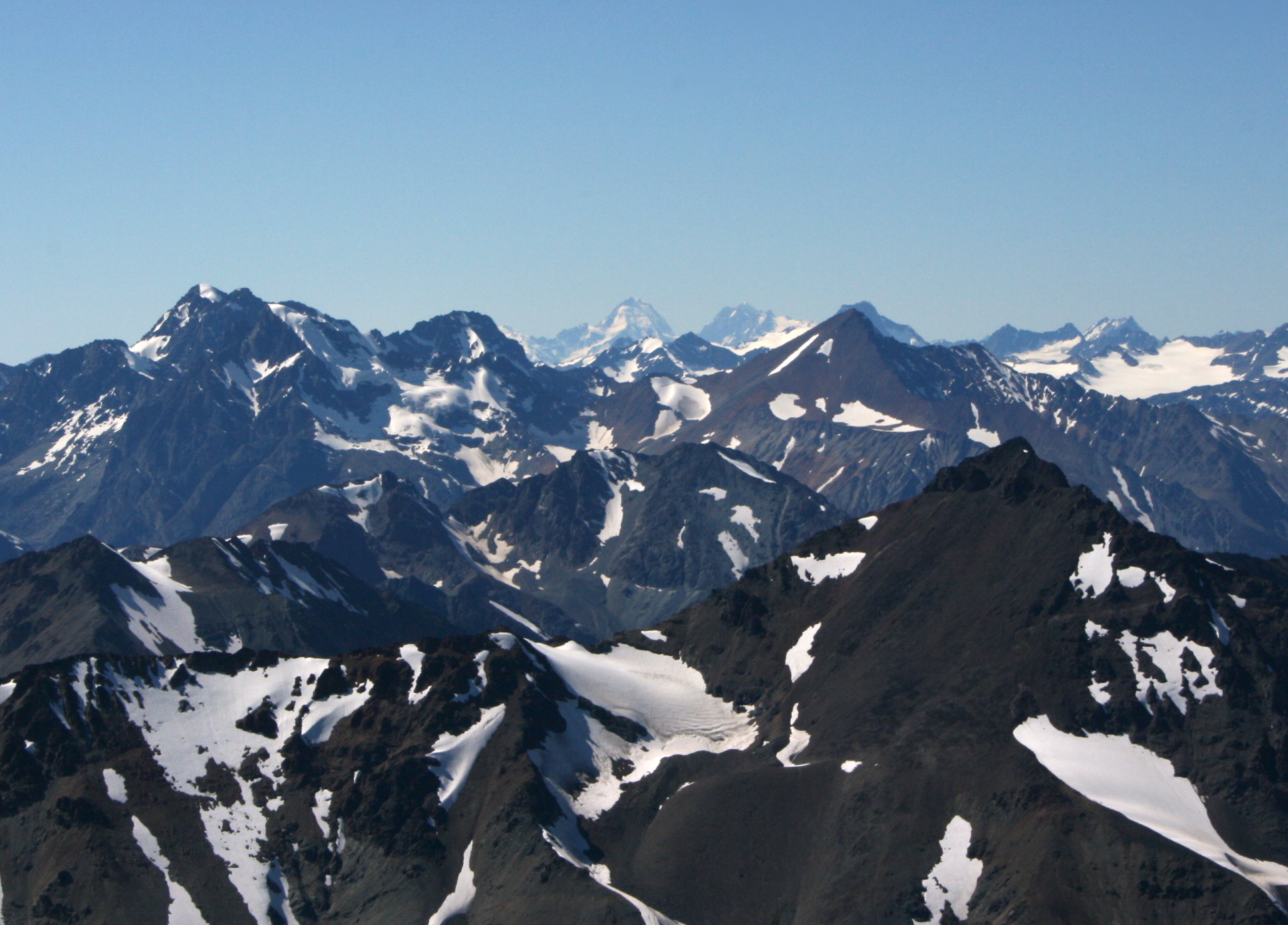
Coast Mountains Coast Range Range  The Coast Mountains, including Mount Waddington (far background, middle) viewed from a distance
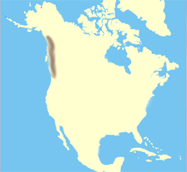
Countries Canada, United States Regions British Columbia, Alaska, Yukon Part of Pacific Coast Ranges Highest point Mount Waddington - location British Columbia - elevation 4,019 m (13,186 ft) - coordinates 51°22′30″N 125°15′30″W / 51.375°N 125.25833°W Length 1,600 km (994 mi), north-south Width 300 km (186 mi), east-west Area 336,962 km2 (130,102 sq mi)  Locator map of the Coast Mountains
The Coast Mountains are a major mountain range, in the Pacific Coast Ranges, of western North America, extending from southwestern Yukon through the Alaska Panhandle and virtually all of the Coast of British Columbia. They are so-named because of their proximity to the sea coast, and are often referred to as the Coast Range.[1] It includes volcanic and non-volcanic mountains and the huge icefields of the Pacific and Boundary Ranges, and the northern end of the notable volcanic system known as the Cascade Volcanoes. The Coast Mountains are part of a larger mountain system called the Pacific Coast Ranges or the Pacific Mountain System, which includes the Cascade Range, the Insular Mountains, the Oregon and California Coast Ranges and the Saint Elias and Chugach Mountains.
The Coast Mountains are approximately 1,600 kilometres (990 mi) long and average 300 kilometres (190 mi) in width.[1] Its southern and southeastern boundaries are surrounded by the Fraser River and the Interior Plateau while its far northwestern edge is delimited by the Kelsall and Tatshenshini Rivers at the north end of the Alaska Panhandle, beyond which are the Saint Elias Mountains, and by Champagne Pass in the Yukon Territory. Covered in dense temperate rainforest on its western exposures, the range rises to heavily glaciated peaks, including the largest temperate-latitude icefields in the world. It then tapers to the dry Interior Plateau on its eastern flanks, or to the subarctic boreal forest of the Skeena Mountains and Stikine Plateau.
The Coast Mountains are part of the Pacific Ring of Fire, the ring of volcanoes and associated mountains around the Pacific Ocean. It contains some of British Columbia's highest mountains. Mount Waddington, northeast of the head of Knight Inlet with an elevation of 4,019 metres (13,186 ft), is the highest mountain of the Coast Mountains and the highest that lies entirely within British Columbia.[2]
Contents
Geography
The Coast Mountains consists of three subdivisions known as the Pacific Ranges, the Kitimat Ranges, and the Boundary Ranges. The Pacific Ranges are the southernmost subdivision of the Coast Mountains, extending from the lower stretches of the Fraser River to Bella Coola. Included in this subdivision is four of the five major coastal icecaps in the southern Coast Mountains. These are the largest temperate-latitude icecaps in the world and fuel a number of major rivers. Other than logging and a large ski resort at the resort town of Whistler, most of the land in the range is completely undeveloped. Mount Waddington, the highest mountain of the Coast Mountains, lies in the Waddington Range of the Pacific Ranges.
Just north of the Pacific Ranges lies the central subdivision known as the Kitimat Ranges. This subdivision extends from the Bella Coola River and Burke Channel in the south to the Nass River in the north.
The third and northernmost subdivision of the Coast Mountains is the Boundary Ranges, extending from the Nass River in the south to the Kelsall River in the north. It is also the largest subdivision of the Coast Mountains, spanning the British Columbia-Alaska border and northwards into Yukon flanking the west side of the Yukon River drainage as far as Champagne Pass, north of which being the Yukon Ranges. The Boundary Ranges include several large icefields, including the Juneau Icefield between Juneau, Alaska and Atlin Lake in British Columbia, and the Stikine Icecap, which lies between the lower Stikine River and the Whiting River.
Because the Coast Mountains are just east of the Pacific Ocean, they have a profound effect on British Columbia's climate by forcing moisture-laden air off the Pacific Ocean to rise, dropping heavy rainfalls on the western slopes where lush forests exist.[1] This precipitation is among the heaviest in North America.[1] The eastern slopes are relatively dry and less steep and protect the British Columbia Interior from the Pacific weather systems, resulting in dry warm summers and dry cold winters.[1]
Beyond the eastern slopes is a 154,635 km2 (59,705 sq mi) plateau occupying the southern and central portions of British Columbia called the Interior Plateau. Included within the Interior Plateau is a coalescing series of layered flood basalt lava flows. These sequences of fluid volcanic rock cover about 25,000 km2 (9,700 sq mi) of the Interior Plateau and have a volume of about 1,800 km3 (430 cu mi), forming a large volcanic plateau constructed atop of the Interior Plateau. North of the Interior Plateau on the range's northeastern slopes lies a huge mountainous area known by geographers as the Interior Mountains, which includes the neighbouring Skeena, Cassiar and Hazelton Mountains.
Geology
Origins and growth
The Coast Mountains consists of deformed igneous and metamorphosed structurally complex pre-Tertiary rocks. These originated in diverse locations around the globe: the area is built of several different terranes of different ages with a broad range of tectonic origins. In addition, oceanic crust under the Pacific Ocean is being subducted at the southern portion of the range to form a north-south line of volcanoes called the Garibaldi Volcanic Belt, a northern extension of the Cascade Volcanoes in the northwestern United States, and contains the most explosive young volcanoes in Canada. Further north the northwesterly structural trend of the Coast Mountains lies partly in a large continental rift responsible for the creation of several volcanoes. These volcanoes form part of the Northern Cordilleran Volcanic Province, the most volcanically active area in Canada.
Insular and Omineca Arc eruptive periods
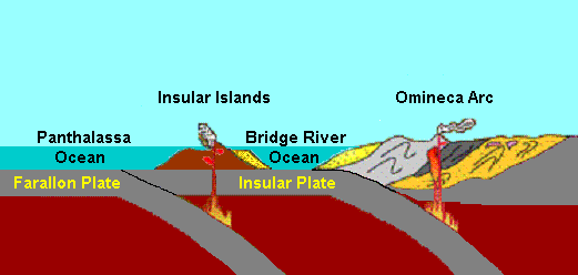
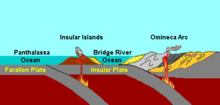 The Bridge River Ocean between North America and the Insular Islands
 Main articles: Insular Islands and Omineca Arc
The first event began 130 million years ago when a group of active volcanic islands approached a pre-existing continental margin and coastline of North America.[3] These volcanic islands, known as the Insular Islands by geoscientists, were formed on a pre-existing tectonic plate called the Insular Plate by subduction of the former Farallon Plate to the west during the early Paleozoic era.[3] This subduction zone records another subduction zone to the east under an ancient ocean basin between the Insular Islands and the former continental margin of North America called the Bridge River Ocean.[3] This arrangement of two parallel subduction zones is unusual in that very few twin subduction zones exist on Earth; the Philippine Mobile Belt off the southeastern coast of Asia is an example of a modern twin subduction zone.[3] As the Insular Plate drew closer to the pre-existing continental margin by ongoing subduction under the Bridge River Ocean, the Insular Islands drew closer to the former continental margin and coastline of western North America, supporting a pre-existing volcanic arc on the former continental margin of North America called the Omineca Arc.[3] As the North American Plate drifted west and the Insular Plate drifted east to the old continental margin of western North America, the Bridge River Ocean eventually closed by ongoing subduction under the Bridge River Ocean.[3] This subduction zone eventually jammed and shut down completely 115 million years ago, ending the Omineca Arc and the Insular Islands collided, forming the Insular Belt.[3] Compression resulting from this collision crushed, fractured and folded rocks along the old continental margin.[3] The Insular Belt then welded onto the pre-existing continental margin by magma that eventually cooled to create a large mass of igneous rock, creating a new continental margin.[3] This large mass of igneous rock is the largest granite outcropping in North America.[3]
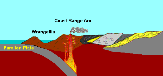
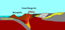 Plate tectonics of the Coast Range Arc 100 million years ago.
Coast Range Arc eruptive period
Main article: Coast Range ArcThe final event began when the Farallon Plate continued to subduct under the new continental margin after the Insular Plate and Insular Islands collided with the old continental margin, supporting a new continental volcanic arc called the Coast Range Arc about 100 million years ago during the Late Cretaceous period.[4] Magma ascending from the Farallon Plate under the new continental margin burned their way upward through the newly accreted Insular Belt, injecting huge quantities of granite into older igneous rocks of the Insular Belt.[3] At the surface, new volcanoes were built along the continental margin.[3] Named after the Coast Mountains, the basement of this arc was likely Early Cretaceous and Late Jurassic intrusions from the Insular Islands.[4]
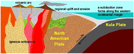
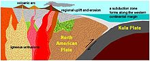 Plate tectonics of the Coast Range Arc about 75 million years ago
One of the major aspects that changed early during the Coast Range Arc was the status of the northern end of the Farallon Plate, a portion now known as the Kula Plate.[3] About 85 million years ago, the Kula Plate broke off from the Farallon Plate to form a mid-ocean ridge known to geoscientists as the Kula-Farallon Ridge.[3] This change apparently had some important ramifications for regional geologic evolution. When this change was completed, Coast Range Arc volcanism returned and sections of the arc were uplifted considerably in latest Cretaceous time.[5] This started a period of mountain building that affected much of western North America called the Laramide orogeny.[6] In particular a large area of dextral transpression and southwest-directed thrust faulting was active from 75 to 65 million years ago.[5] Much of the record of this deformation has been overridden by Tertiary age structures and the zone of Cretaceous dextral thrust faulting appears to have been widespread.[5] It was also during this period when massive amounts of molten granite intruded highly deformed ocean rocks and assorted fragments from pre-existing island arcs, largely remnants of the Bridge River Ocean.[3] This molten granite burned the old oceanic sediments into a glittering medium-grade metamorphic rock called schist.[3] The older intrusions of the Coast Range Arc were then deformed under the heat and pressure of later intrusions, turning them into layered metamorphic rock known as gneiss.[3] In some places, mixtures of older intrusive rocks and the original oceanic rocks have been distorted and warped under intense heat, weight and stress to create unusual swirled patters known as migmatite, appearing to have been nearly melted in the procedure.[3]
Volcanism began to decline along the length of the arc about 60 million years ago during the Albian and Aptian faunal stages of the Cretaceous period.[4] This resulted from the changing geometry of the Kula Plate, which progressively developed a more northerly movement along the Pacific Northwest.[3] Instead of subducting beneath the Pacific Northwest, the Kula Plate began subducting underneath southwestern Yukon and Alaska and during the early Eocene period.[3] Volcanism along the entire length of the Coast Range Arc shut down about 50 million years ago and many of the volcanoes have disappeared from erosion.[3] What remains of the Coast Range Arc to this day are outcrops of granite when magma intruded and cooled at depth beneath the volcanoes, forming the present Coast Mountains.[3] During construction of intrusions 70 and 57 million years ago, the northern motion of the Kula Plate might have been between 140 mm (6 in) and 110 mm (4 in) per year.[7] However, other geologic studies determined the Kula Plate moved at a rate as fast as 200 mm (8 in) per year.[7]
High-prominence peaks
 The North Shore Mountains near Vancouver.
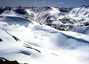
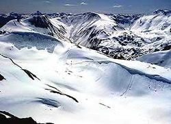 View of the Juneau Icefield.
Mountain/Peak Height (metres) Prominence (metres) Height (feet) Prominence (feet) Location Mount Waddington 4019 3289 13,186 10,791 Monarch Mountain 3555 2930 11,663 9,613 Skihist Mountain 2968 2463 9,738 8,081 Mount Ratz 3090 2430 10,138 7,972 Mount Queen Bess 3298 2355 10,820 7,726 Razorback Mountain 3183 2253 10,295 7,392 Wedge Mountain 2892 2249 9,488 7,379 Otter Mountain 2692 2242 8,832 7,356 Mount Silverthrone 2860 974 9,383 3,196 Kwatna Peak 2290 2225 7,513 7,300 Scud Peak 2987 2172 9,800 7,126 Mountain ranges
Range Name Parent Region(s) Country Boundary Ranges Coast Mountains British Columbia, Yukon, Alaska Canada, United States Boundary Range Boundary Ranges British Columbia, Alaska Canada, United States Adam Mountains Boundary Ranges Alaska United States Ashington Range Boundary Ranges British Columbia Canada Burniston Range Boundary Ranges British Columbia Canada Dezadeash Range Boundary Ranges Yukon Canada Florence Range Boundary Ranges British Columbia Canada Halleck Range Boundary Ranges Alaska United States Juneau Icefield Boundary Ranges British Columbia, Alaska Canada, United States Sawtooth Range Juneau Icefield Alaska United States Kakuhan Range Boundary Ranges Alaska United States Lincoln Mountains Boundary Ranges Alaska United States Longview Range Boundary Ranges British Columbia Canada Peabody Mountains Boundary Ranges Alaska United States Rousseau Range Boundary Ranges Alaska United States Seward Mountains Boundary Ranges Alaska United States Snowslide Range Boundary Ranges British Columbia Canada Spectrum Range Boundary Ranges British Columbia Canada Stikine Icecap Boundary Ranges British Columbia, Alaska Canada, United States Chechidla Range Stikine Icecap British Columbia Canada Cheja Range Stikine Icecap British Columbia Canada Kitimat Ranges Coast Mountains British Columbia Canada Bare Top Range Kitimat Ranges British Columbia Canada Countess of Dufferin Range Kitimat Ranges British Columbia Canada Kitlope Range Kitimat Ranges British Columbia Canada North Coastal Archipelago Kitimat Ranges British Columbia Canada Bell Range North Coastal Archipelago British Columbia Canada Burnaby Range North Coastal Archipelago British Columbia Canada Cape Range North Coastal Archipelago British Columbia Canada Chismore Range North Coastal Archipelago British Columbia Canada Murphy Range North Coastal Archipelago British Columbia Canada Richardson Range North Coastal Archipelago British Columbia Canada Spiller Range North Coastal Archipelago British Columbia Canada Williams Range North Coastal Archipelago British Columbia Canada Wimbledon Range North Coastal Archipelago British Columbia Canada Tenaiko Range Kitimat Ranges British Columbia Canada Pacific Ranges Coast Mountains British Columbia Canada Ashlu-Elaho Divide Pacific Ranges British Columbia Canada Bazalgette Range Pacific Ranges British Columbia Canada Bendor Range Pacific Ranges British Columbia Canada Bridge-Lillooet Divide Pacific Ranges British Columbia Canada Broughton Archipelago Pacific Ranges British Columbia Canada Calliope Range Broughton Archipelago British Columbia Canada Georgina Range Broughton Archipelago British Columbia Canada Bunster Range Pacific Ranges British Columbia Canada Cadwallader Range Pacific Ranges British Columbia Canada Caren Range Pacific Ranges British Columbia Canada Charlotte Alplands Pacific Ranges British Columbia Canada Douglas Ranges Pacific Ranges British Columbia Canada Chilcotin Ranges Pacific Ranges British Columbia Canada Camelsfoot Range Chilcotin Ranges British Columbia Canada Dickson Range Chilcotin Ranges British Columbia Canada Leckie Range Chilcotin Ranges British Columbia Canada Pantheon Range Chilcotin Ranges British Columbia Canada Potato Range Chilcotin Ranges British Columbia Canada Shulaps Range Chilcotin Ranges British Columbia Canada Clendinning Range Pacific Ranges British Columbia Canada Colville Range Pacific Ranges British Columbia Canada Conical Range Pacific Ranges British Columbia Canada Earle Range Pacific Ranges British Columbia Canada Edwards Range Pacific Ranges British Columbia Canada Florence Range Pacific Ranges British Columbia Canada Franklyn Range Pacific Ranges British Columbia Canada Fraser Range Pacific Ranges British Columbia Canada Garibaldi Ranges Pacific Ranges British Columbia Canada Garibaldi Névé Garibaldi Ranges British Columbia Canada Fitzsimmons Range Garibaldi Ranges British Columbia Canada McBride Range Garibaldi Ranges British Columbia Canada Spearhead Range Garibaldi Ranges British Columbia Canada Golden Ears Garibaldi Ranges British Columbia Canada Misty Icefield Garibaldi Ranges British Columbia Canada Bastion Range Garibaldi Ranges British Columbia Canada Gastineau Range Pacific Ranges British Columbia Canada Ha-Iltzuk Icefield Pacific Ranges British Columbia Canada Homathko Icefield Pacific Ranges British Columbia Canada Koeye Range Pacific Ranges British Columbia Canada Lewis Range Pacific Ranges British Columbia Canada Lillooet Icecap Pacific Ranges British Columbia Canada Compton Névé Lillooet Icefield British Columbia Canada Lillooet Ranges Pacific Ranges British Columbia Canada Cantilever Range Lillooet Ranges British Columbia Canada Cayoosh Range Lillooet Ranges British Columbia Canada Mission Ridge Pacific Ranges British Columbia Canada Monarch Icefield Pacific Ranges British Columbia Canada North Shore Mountains Pacific Ranges British Columbia Canada Fannin Range North Shore Mountains British Columbia Canada Britannia Range North Shore Mountains British Columbia Canada Namu Range Pacific Ranges British Columbia Canada Nicholl Range Pacific Ranges British Columbia Canada Niut Range Pacific Ranges British Columbia Canada Pemberton Icefield Pacific Ranges British Columbia Canada Pembroke Range Pacific Ranges British Columbia Canada Powell Divide Pacific Ranges British Columbia Canada Sir Harry Range Pacific Ranges British Columbia Canada Squamish-Cheakamus Divide Pacific Ranges British Columbia Canada Tantalus Range Pacific Ranges British Columbia Canada The Tahumming Pacific Ranges British Columbia Canada Tottenham Range Pacific Ranges British Columbia Canada Unwin Range Pacific Ranges British Columbia Canada Waddington Range Pacific Ranges British Columbia Canada Wharncliffe Range Pacific Ranges British Columbia Canada Whitemantle Range Pacific Ranges British Columbia Canada See also
- Coast Range Arc
- Geography of British Columbia
- Geology of British Columbia
- Volcanism of Canada
- Volcanism of Western Canada
- List of mountain ranges
- Rocky Mountains
- Columbia Mountains
References
- ^ a b c d e "BCGNIS Query Results". Government of British Columbia. http://www.ilmb.gov.bc.ca/bcgn-bin/bcg10?name=21188. Retrieved 2008-11-13.[dead link]
- ^ "BCGNIS Query Results". Government of British Columbia. http://ilmbwww.gov.bc.ca/bcgn-bin/bcg10?name=38556. Retrieved 2008-11-13.[dead link]
- ^ a b c d e f g h i j k l m n o p q r s t u v "The Coast Range Episode (115 to 57 million years ago)". Burke Museum of Natural History and Culture. http://www.washington.edu/burkemuseum/geo_history_wa/Coast%20Range%20Episode.htm. Retrieved 2008-04-09.
- ^ a b c Stowell, Harold H.; McClelland William C.. Tectonics of the Coast Mountains, Southeastern Alaska and British Columbia. Geological Society of America. pp. 101. ISBN 0-8137-2343-4. http://books.google.ca/books?hl=en&id=5SgAthT0MuAC&dq=tectonics+of+the+Coast+Mountains+southeastern+Alaska+and+British+Columbia&printsec=frontcover&source=web&ots=VTbyAo5kZR&sig=p9GFjhGDysA1miKDghAvzNQnMf8&sa=X&oi=book_result&resnum=1&ct=result. Retrieved 2008-09-04.
- ^ a b c [1]
- ^ "Laramide orogeny". Encyclopaedia Britannica, Inc.. 1998. http://tlacaelel.igeofcu.unam.mx/~GeoD/colision/figs/orogeny/laramide.html. Retrieved November 16, 2008.
- ^ a b "Tectonic overview of the CPC". University of Arizona. http://www.geo.arizona.edu/tectonics/Ducea/Batholiths/Tectonics.htm. Retrieved 2008-09-07.
Coast Mountains of North America Ranges Adam · Ashington · Bastion · Bare Top · Bell · Bendor · Boundary · Boundary · Britannia · Bunster · Burnaby · Burniston · Cadwallader · Calliope · Camelsfoot · Cantilever · Caren · Cape · Chechidla · Cheja · Chilcotin · Chismore · Clendinning · Colville · Conical · Countess of Dufferin · Dezadeash · Dickson · Douglas · Earle · Edwards · Fannin · Fitzsimmons · Florence · Franklyn · Fraser · Garibaldi · Gastineau · Georgina · Halleck · Kakuhan · Kitimat · Kitlope · Koeye · Leckie · Lewis · Lillooet · Lincoln · Longview · McBride · Mission · Murphy · Namu · Nicholl · Niut · North Shore · Pacific · Pantheon · Peabody · Pembroke · Potato · Richardson · Rousseau · Sawtooth · Seward · Sir Harry · Snowslide · Shulaps · Spearhead · Spiller · Tantalus · Tenaiko · Tottenham · Unwin · Waddington · Wharncliffe · Whitemantle · Williams · WimbledonMountains Alfred · Alice · Arthur · Birkenhead · Bishop · Blackcomb · Blanshard · Brandywine · Brew · Burke · Castle Towers · Chutine · Cinder · Clarke · Coquitlam · Crickmer · Crown · Currie · Cypress · Devils Paw · Devils Thumb · Dewdney · Dipyramid · Eagle · Elsay · Fang · Fitzgerald · Forefinger · Frederick William · Fromme · Garibaldi · Good Hope · Grouse · Helena · Hoodoo · Judge Howay · Kates Needle · Kinch · Little Bear · Little Finger · Little Ring · London · Luna · Meager · Merlon · Middle Finger · Monarch · Monmouth · Munday · Nicomen · One Eye · Overill · Pali · Powder · Price · Queen Bess · Raleigh · Robie Reid · Serratus · Seymour · Silverthrone · Skihist · Somolenko · Tantalus · Taseko · Tatlow · Red Tusk · Spearhead · Tiedemann · Vic · Victoria · Waddington · Wedge · WellingtonPasses Glaciers Cambria · Diamond · Ha-Iltzuk · Homathko · Hoodoo · Juneau · Kingcome · Klinaklini · Misty · Monarch · Pashleth · Pemberton · Powder Mountain · Salmon · Silverthrone · Spearhead · Stikine · TwinParks Categories:- Coast Mountains
- Pacific Coast Ranges
- Mountain ranges of British Columbia
- Mountain ranges of Yukon
- Mountain ranges of Alaska
- Coast of British Columbia
Wikimedia Foundation. 2010.