- Pacific Ranges
Geobox|Range
name=Pacific Ranges
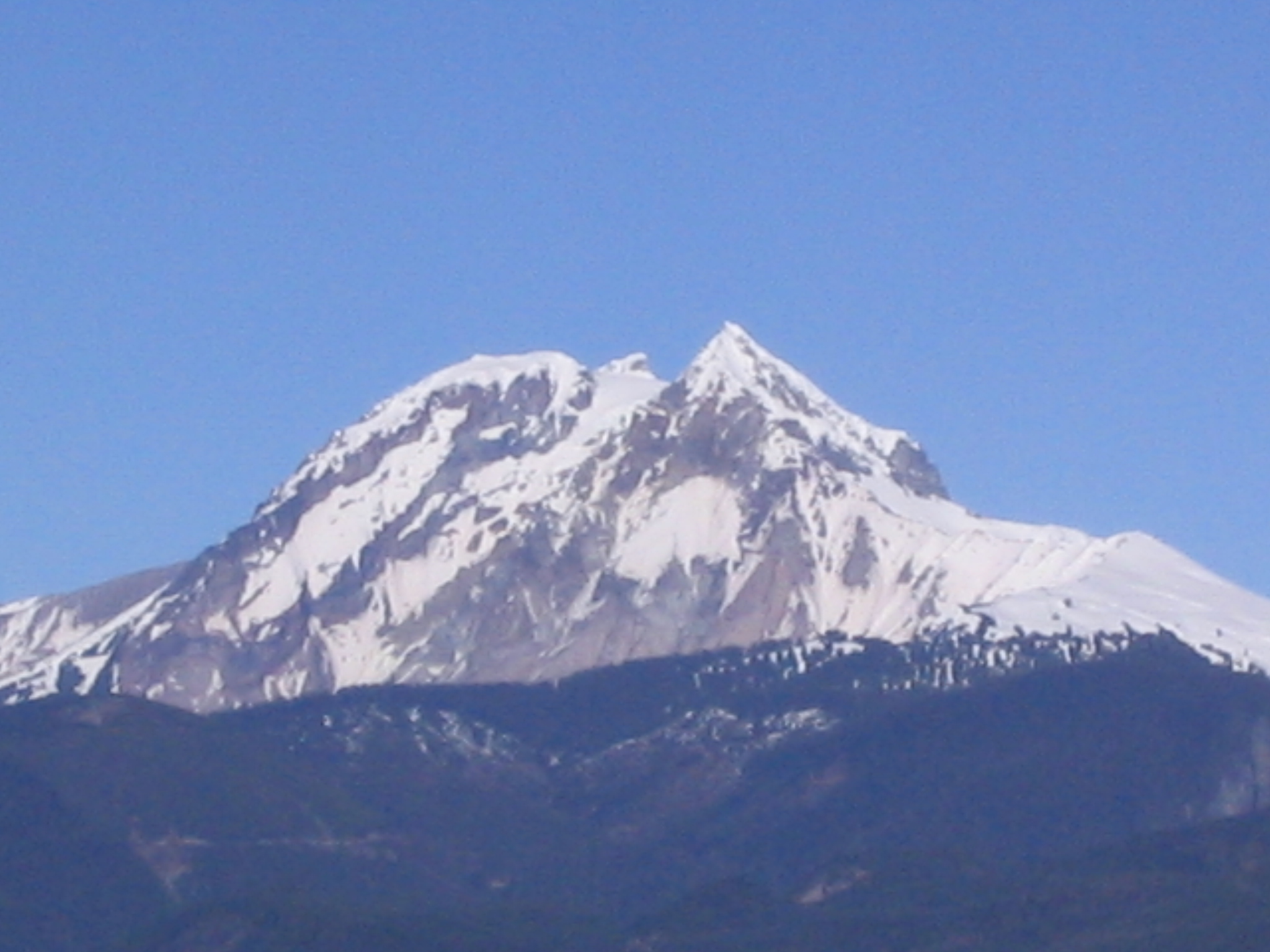
image_caption=Mount Garibaldi
country=Canada
region_type=Province
region=British Columbia
parent=Coast Mountains
highest=Mount Waddington
highest_elevation=4016
highest_lat_d=51|highest_lat_m=22|highest_lat_s=30|highest_lat_NS=N
highest_long_d=125|highest_long_m=15|highest_long_s=30|highest_long_EW=W
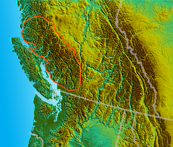
map_caption=Pacific Ranges as defined in S. Holland "Landforms of British Columbia"The Pacific Ranges are the southernmost subdivision of theCoast Mountains portion of thePacific Cordillera . Located entirely within British Columbia, Canada, they run northwest from the lower stretches of theFraser River to Bella Coola, north of which are theKitimat Ranges .The Pacific Ranges include four of the five major coastal icecaps in the southern
Coast Mountains . These are the largest temperate-latitude icecaps in the world and fuel a number of very major rivers (by volume, not length). One of these containsMount Waddington , the highest summit entirely withinBritish Columbia . Also within this region isHunlen Falls , among the highest inCanada , located inTweedsmuir South Provincial Park .Other than logging and a large ski resort at Whistler most of the land in the range is completely undeveloped. Historically, in the southern part of the range, mining was important at various times in the Lillooet, Bridge River and Squamish areas, and large pulp and paper mills at Powell River, Port Mellon and Woodfibre. The largest hydroelectric development in the Pacific Ranges is the
Bridge River Power Project , though smaller hydro plants are on the Stave River-Alouette Lake system in Mission and Maple Ridge, the Daisy Lake-Squamish River division of the Cheakamus Powerhouse, and another power dam and power plant atClowhom . Although the range was extensively surveyed for possible rail routes, only that of the Pacific Great Eastern (now part of CN) was eventually built; the Homathko River-Bute Inlet route, however, was one of the two main choices in the deliberations of the CPR's routing.Geography
The Pacific Ranges are part of the southern portion of the
Coast Plutonic Complex and has been characterized by rapid rates of uplift over the past 4 million years, which has led to relatively high rates oferosion .The
Garibaldi Volcanic Belt is within the Pacific Ranges, which is avolcanic belt formed by thesubduction of theJuan de Fuca Plate (a remnant of the much largerFarallon Plate ) under theNorth American Plate along theCascadia subduction zone . The belt is the northern extension of the Cascade Volcanic Arc in theUnited States (which includes the volcanoesMount St. Helens andMount Baker ) and contains the most explosive young volcanoes in Canada. The eruption styles in the belt range from effusive to explosive, with compositions frombasalt torhyolite . Morphologically, centers includecaldera s,cinder cone s,stratovolcano es and small isolatedlava masses. Due to repeated continental and alpine glaciations, many of the volcanic deposits in the belt reflect complex interactions betweenmagma composition, topography, and changing ice configurations. The most recent major catastrophic eruption in the Garibaldi Volcanic Belt was fromMount Meager 2,350 BP, which is Canada's most recent major catastrophic eruption.The Garibaldi Volcanic Belt contains 2 extra volcanic fields, the
Franklin Glacier Volcano and theSilverthrone Caldera , which lie 140 and 190 km northwest of the main volcanic belt.The
Cascadia subduction zone is a 680 mi (1,094 km) long fault, running 50 mi (80 km) off the west-coast of thePacific Northwest fromnorthern California toVancouver Island . The plates move at a relative rate of over 0.4 inches (10 mm) per year at a somewhat oblique angle to the subduction zone.Unlike most subduction zones worldwide, there is no
oceanic trench present along thecontinental margin inCascadia . Instead,terrane s and the accretionary wedge have been uplifted to form a series of coast ranges and exotic mountains. A high rate of sedimentation from the outflow of the three major rivers (Fraser River ,Columbia River , andKlamath River ) which cross the Cascade Range contributes to further obscuring the presence of a trench. However, in common with most other subduction zones, the outer margin is slowly being compressed, similar to a giant spring. When the stored energy is suddenly released by slippage across the fault at irregular intervals, the Cascadia subduction zone can create very largeearthquake s such as the magnitude 9 Cascadia earthquake of 1700.Major Named Subranges:
*Rainbow Range
*Niut Range
*Pantheon Range
*Waddington Range
*Whitemantle Range
*Chilcotin Ranges
**Shulaps Range
**Dickson Range
**Camelsfoot Range
*Bendor Range
*Lillooet Ranges
**Cayoosh Range
**Cantilever Range
*Douglas Ranges
*Garibaldi Ranges
*North Shore Mountains (Front Ranges)
*Tantalus Range
*Clendinning Range **the
Camelsfoot Range running north along the west bank of the Fraser from Lillooet is sometimes considered to be part of the Chilcotin Ranges, but in other definitions is part of theInterior Plateau "Many smaller ranges and subranges are not listed at present."
Major Icefields:
"(Other than the
Waddington Range these are also considered to be "ranges " but are listed separately here because of their unique character)."*
Monarch Icefield
*Ha-Iltzuk Icefield (Silverthrone Glacier)
*Waddington Range
*Homathko Icefield
*Lillooet Icecap (Lillooet Crown)
*Pemberton Icecap Major Peaks
*
Mount Waddington
*Monarch Mountain
*Mount Tiedemann
*Mount Munday *
Mount Queen Bess
*Mount Good Hope
*Mount Raleigh
*Monmouth Mountain
*Mount Tatlow
*Taseko Mountain
*Mount Silverthrone
*Mount Meager
*Mount Cayley
*Mount Garibaldi
*Wedge Mountain Provincial Parks
*
Garibaldi Provincial Park
*Golden Ears Provincial Park
*Cypress Provincial Park
*Mount Seymour Provincial Park
*Sasquatch Provincial Park
*Stein Valley Nlaka'pamux Heritage Park
*Birkenhead Lake Provincial Park
*Big Creek Provincial Park
*Spruce Lake Protected Area
*Ts'il?os Provincial Park
*Tweedsmuir North Provincial Park and Protected Area
*Tweedsmuir South Provincial Park "List is incomplete""Some Protected areas, recreation areas and other non-park preservation areas are not listed."
Major Rivers
*
Fraser River
*Chilcotin River
*Bridge River
*Lillooet River
*Squamish River
*Homathko River
*Klinaklini River
*Bella Coola River "Many relatively unknown rivers of considerable size along the coastal flank of the range are not listed, partly because they are largely unknown and also very difficult to access."
External links
* [http://bivouac.com/ArxPg.asp?ArxId=1640 Canadian Mountain Encyclopedia article on the Pacific Ranges]
Wikimedia Foundation. 2010.