- Fraser River
Geobox River
name =
native_name =
other_name =
other_name1 =
image_size =
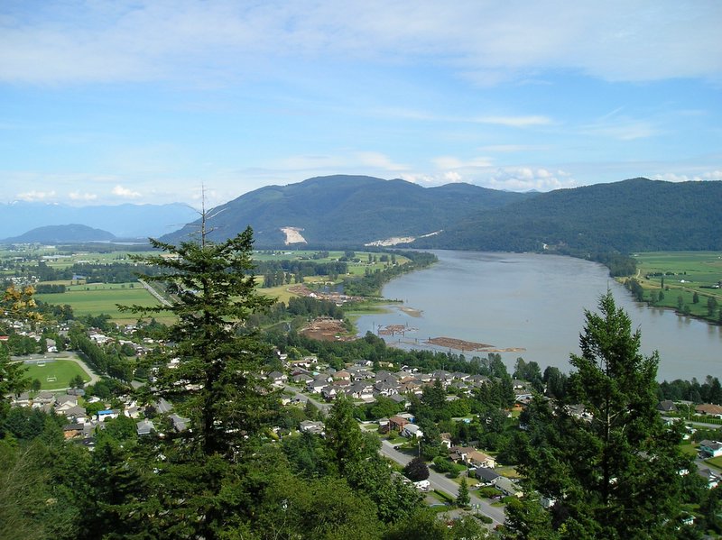
image_caption = The Fraser River, from the grounds of Westminster Abbey, above Hatzic nearMission, British Columbia , looking upstream (E).
country = Canada
country1 =
state_type = Province
state = British Columbia
state1 =
region =
region1 =
district =
district1 =
city =
city1 =
length = 1375
length_note =cite web|url=http://www.chrs.ca/Rivers/Fraser/Fraser_e.htm |title=Fraser River|work=Canadian Heritage Rivers System]
watershed = 220000
discharge_location = mouth
discharge_average = 3475
discharge_max = 139000
discharge_min = 575
discharge_note = [ [http://www.env.gov.bc.ca/wat/wq/objectives/fraserkanaka/fraserkanaka.html#introduction Ambient Water Quality Asessment and Objectives for the Fraser River sub-basin from Kanaka Creek to the Mouth] , BC Ministry of Environment]
discharge1_location =
discharge1_average =
source_name = Continental Divide
source_location = Rocky Mountains
source_district =
source_region = Mount Robson Provincial Park
source_state = British Columbia
source_country = Canada
source_lat_d = 52
source_lat_m = 31.1
source_lat_s =
source_lat_NS = N
source_long_d = 118
source_long_m = 19.0
source_long_s =
source_long_EW = W
source_elevation =
source_length =
mouth_name = Fraser River Delta
mouth_location = Strait of Georgia
mouth_district = Greater Vancouver Regional District
mouth_region = Vancouver
mouth_state = British Columbia
mouth_country = Canada
mouth_lat_d = 49
mouth_lat_m = 7
mouth_lat_s =
mouth_lat_NS = N
mouth_long_d = 123
mouth_long_m = 11.5
mouth_long_s =
mouth_long_EW = W
mouth_elevation = 0
tributary_right = McGregor River
tributary_left = Willow River
tributary_right1 = Nechako River
tributary_left1 = Quesnel River
tributary_right2 = West Road River
tributary_left2 = Thompson River
tributary_left3 = Williams Lake River
tributary_right3 = Chilcotin River
tributary_right4 = Bridge River
tributary_left4 = Coquihalla River
tributary_right5 = Harrison River
tributary_left5 = Vedder River
tributary_right6 = Stave River
tributary right7 = Pitt River
tributary right8 = Coquitlam River
free_name =
free_value =
map_size =
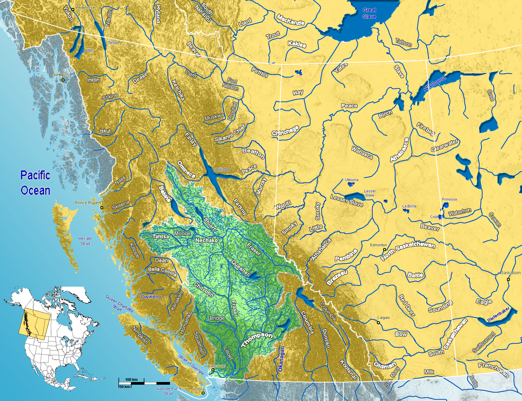
map_caption = Fraser River watershed:"For other uses of this name see
Fraser River (disambiguation) ". The Fraser River is the longest river inBritish Columbia ,Canada , rising nearMount Robson in theRocky Mountains and flowing for 1,375 km (870 mi), into thePacific Ocean at the city of Vancouver. The estuary at the river's mouth is a site of hemispheric importance in theWestern Hemisphere Shorebird Reserve Network .Cite web
url=http://www.whsrn.org/FraserRiverEstuary/index.html
title=Description
publisher=Western Hemisphere Shorebird Reserve Network
accessdate=2008-02-18]Geography
The Fraser drains a 220,000 km² (85,000 sq mi) area. Its
headwaters are in theYellowhead Pass , which forms the first part of its course before its descent at Valemount to theRocky Mountain Trench through which it runs northwest via a region known as theRobson Valley . After running northwest past 54° north, it makes a sharp turn to the south, meeting theNechako River at the city of Prince George, then continuing south, progressively cutting deeper and deeper into theFraser Plateau to form theFraser Canyon from roughly the confluence of theChilcotin River , near the city of Williams Lake southwards. It is joined by the Bridge andSeton River s at the town of Lillooet, then by theThompson River at Lytton, where it proceeds south until it is approximately 40 km (25 mi) north of the 49th parallel, which is Canada's border with theUnited States . It then runs through a progressively deeper canyon between theLillooet Ranges of theCoast Mountains on its west and theCascade Mountains on its east. At Yale, at the head of navigation on the river, the canyon opens up and the river is wider, though wihtout much adjoining lowland until Hope, where the river then turns west and southwest a lush lowland valley, known as theFraser Valley , past Chilliwack and the confluence of the Harrison andSumas River s, bending northwest at Abbotsford and Mission, turning southwest again just east ofNew Westminster and the eastern and southern suburbs of Vancouver.After 100 kilometres (about 60 mi), it forms a delta where it empties into the
Strait of Georgia between the mainland andVancouver Island . The lands south of the City of Vancouver, including the cities of Richmond and Delta sit on the flatflood plain . The islands of the delta include Iona Island, Sea Island,Lulu Island ,Annacis Island , and a number of smaller islands. While the vast majority of the river's drainage basin lies within British Columbia, a small portion in the delta area lies across the international border inWashington in the United States, as does the upper reaches of the tributary Chilliwack River andSumas River .The river's volume at its mouth is 112 km³ (27 cu mi) each year (about 800,000 gal/s or 3550 cubic metres per second), and it dumps 20 million tons of sediment into the ocean. [Cannings, Richard and Sidney. British Columbia: A Natural History. p.41. Greystone Books. Vancouver. 1996] It is the tenth longest river in Canada. [Canadian Global Almanac. John Wiley and Sons. 2004]
History
On
June 14 ,1792 , the Spanish explorersDionisio Alcalá Galiano and Cayetano Valdés entered and anchored in the north arm of the Fraser River, becoming the first Europeans to find and enter it. [cite book |last= Hayes |first= Derek |title= Historical Atlas of the Pacific Northwest: Maps of exploration and Discovery |year= 1999 |publisher= Sasquatch Books |isbn= 1-57061-215-3] The existence of the river, but not its location, had been deduced during the 1791 voyage ofJosé María Narváez , underFrancisco de Eliza .The upper reaches of the Fraser River were first explored by
Sir Alexander Mackenzie in1793 , and fully traced by Simon Fraser in1807 , who confirmed that it was not connected with theColumbia River .In 1828 George Simpson visited the river, mainly to examine Fort Langley and determine whether it would be suitable as the company's main Pacific depot. Simpson had believed the Fraser River might be navigable throughout its length, even though Simon Fraser had described it as non-navigable. Simpson journeyed down the river and through the
Fraser Canyon and afterwords wrote "I should consider the passage down, to be certain Death, in nine attempts out of Ten. I shall therefore no longer talk about it as a navigable stream". His trip down the river convinced him that Fort Langley could not replaceFort Vancouver as the company's main depot on the Pacific coast. [cite book |last= Mackie |first= Richard Somerset |title= Trading Beyond the Mountains: The British Fur Trade on the Pacific 1793-1843 |year= 1997 |publisher= University of British Columbia (UBC) Press |location= Vancouver |isbn= 0-7748-0613-3 |pages= p. 58]Much of British Columbia's history has been bound to the Fraser, partly because it was the essential route between the Interior and the Lower Coast after the loss of the lands south of the 49th Parallel with the
Oregon Treaty of 1846. [cite web|url=http://www.ccge.org/ccge/english/Resources/rivers/tr_rivers_fraserRiver.asp|title=Fraser River|work= Canadian Council for Geographic Education] It was the site of its first recorded settlements of Aboriginal people ("see" ,St'at'imc andNlaka'pamux ), the route of multitudes of prospectors during theFraser Canyon Gold Rush and the main vehicle of the province's early commerce and industry.This river has been designated a Canadian Heritage River for its natural and human heritage.cite web|url=http://www.chrs.ca/Rivers/Fraser/Fraser_e.htm |title=Fraser River|work=Canadian Heritage Rivers System]
Uses
The Fraser is heavily exploited by human activities, especially in its lower reaches. Its banks are rich farmland, its water is used by
pulp mill s, and a few dams on some tributaries providehydroelectric power . The main flow of the Fraser has never been dammed as its high level of sediment flows would result in a short dam lifespan. Today,Fraser Herald at theCanadian Heraldic Authority is named after the river. In 1858, the Fraser River and surrounding areas were occupied when the gold rush came to the Fraser Canyon and the Fraser River.The delta of the river, especially in the
Boundary Bay area, is an important stopover location for migratingshorebird s [cite web|url=http://www.reifelbirdsanctuary.com/|title=Reifel Bird Sanctuary]Flooding
The first disastrous flood in the Fraser Valley occurred in 1894. With no protection against the rising waters of the Fraser River, Fraser Valley communities from Chilliwack downstream were inundated with water.
After the 1894 flood, a dyking system was constructed throughout the Fraser Valley. The dyking and drainage projects greatly improved the flood problems, but unfortunately over time, the dykes were allowed to fall into disrepair and became overgrown with brush and trees. With some dykes constructed of a wooden frame, they gave way in 1948 in several locations, marking the second disastrous flood.
1894, June, the Fraser River flooded Chilliwack and the Fraser Valley. The high water mark at Mission reached 25.75’.
[

Mission, British Columbia June 3, 1948]1948 saw massive flooding in Chilliwack and other areas along the Fraser River. The high water mark at Mission rose to 24.7’.
Timeline of 1948 flood
*Throughout the May 24 long weekend, the waters of the Fraser were rising steadily, but only a few thought any real danger lay ahead.
*On May 28, 1948, the Semiault Creek Dyke broke.
*On May 29, 1948, dykes near Glendale (now Cottonwood Corners) gave way and in four days, 12,000 acres of fertile ground were under water.
*On June 1, 1948, the Cannor Dyke (east of Vedder Canal near Trans Canada Highway) broke and released tons of Fraser River water onto the Greendale area, destroying homes and fields.
*In June 3, 1948, the steamer "Gladys" supplied flood-stricken Chilliwack with tents and provisions as well as moving people and stock onto high ground.Reasons for the flood of 1948
Cool temperatures during March, April and early May had delayed the melting of the heavy snowpack that had accumulated over the winter season. Several days of hot weather and warm rains over the holiday weekend in late May hastened the thawing of the snowpack. Rivers and streams quickly swelled with spring runoff, reaching heights surpassed only in 1894.
At the height of the 1948 flood, 50,000 acres stood under water. Dykes broke at Agassiz, Chiliwack, Nicomen Island, Glen Valley and Matsqui. By the time the flood waters receded a month later, 16,000 people had been evacuated, damages totaled $20 million.
Due to record snowpacks on the mountains in the Fraser River catch basin which began melting, combined with heavy rainfall, water levels on the Fraser River rose in 2007 to a level not reached since 1972. [ [http://www.pgfreepress.com/portals-code/list.cgi?paper=26&cat=23&id=999153&more=0 River Water Still Rising] . "Prince George Free Press",
June 6 ,2006 .] Low-lying land in areas upriver such as Prince George suffered minor flooding. Evacuation alerts were given for the low-lying areas not protected by dikes in theLower Mainland . [ [http://www.langleytimes.com/portals-code/list.cgi?paper=47&cat=23&id=999195&more=0 Fraser flood alert imminent Mission gauge under close scrutiny, river likely to peak at 7.5 m by Saturday] . "Langley Times",June 6 ,2007 .] However, the water levels did not breach the dikes, and major flooding was averted. Fountain, 15km upstream from Lillooet
Tributaries
*
Coquitlam River
*Pitt River
**Alouette River
**Widgeon Creek
*Stave River
*Sumas River
**Vedder River (Chilliwack River)
*Harrison River
**Chehalis River
** Silver River (Big Silver River)
**Lillooet River
***Green River
****Rutherford Creek
****Soo River
****Green Lake
*****Fitzsimmons Creek
*****River of Golden Dreams
******Alta Lake
***Birkenhead River
***Ryan River
***Meager Creek
*Sumallo River
*Coquihalla River
* Anderson River
*Nahatlatch River
*Thompson River
**Nicola River
***Coldwater River
**Bonaparte River
*** Cache Creek
*** Hat Creek
**Deadman River
**Kamloops Lake
***North Thompson River
****Clearwater River
*****Azure River
*****Murtle River
*****Mahood River
******Mahood Lake
*******Canim River
********Canim Lake
********* Bridge Creek
***South Thompson River
****Little Shuswap Lake
*****Little River
******Shuswap Lake
*******Adams River
*******Anstey River
******* Seymour River
******* Eagle River
******* Salmon River
********Mara Lake
*********Shuswap River
*********Mabel Lake
**********Wap Creek
**********Shuswap River
***********Sugar Lake
*Stein River
*Seton River
**Seton Lake
***Seton River
**** Anderson Lake
*****Gates River
******Haylmore Creek
*Bridge River
**Yalakom River
***Carpenter Lake
****Tyaughton Creek
****Gun Creek
***Hurley River
*Churn Creek
*Chilcotin River
** Big Creek
**Taseko River
***Taseko Lakes
**Chilko River
***Chilko Lake
**Chilanko River
*Williams Lake River
** San Jose River
*West Road River (Blackwater River)
*Quesnel River
**Cariboo River
**Horsefly River
*Nechako River
**Stuart River
*** Stuart Lake
**Endako River
**Nautley River
***Ootsa lake Reservoir
* Salmon River
* Willow River
*McGregor River
**Herrick Creek
* Milk River
*Rausch River ee also
*
List of crossings of the Fraser River
*Fraser Canyon References
External links
* [http://www.aquatic.uoguelph.ca/rivers/fraser.htm Map and photographs]
Wikimedia Foundation. 2010.