- Fold (geology)
-
For other uses, see Fold (disambiguation).
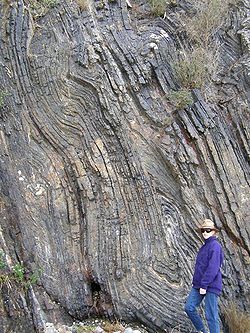
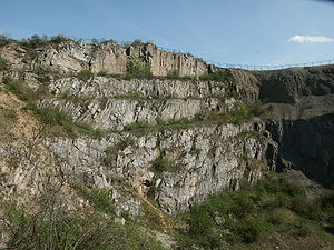
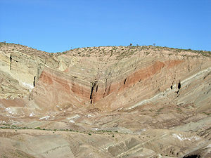
The term fold is used in geology when one or a stack of originally flat and planar surfaces, such as sedimentary strata, are bent or curved as a result of permanent deformation. Synsedimentary folds are those due to slumping of sedimentary material before it is lithified. Folds in rocks vary in size from microscopic crinkles to mountain-sized folds. They occur singly as isolated folds and in extensive fold trains of different sizes, on a variety of scales. Folds form under varied conditions of stress, hydrostatic pressure, pore pressure, and temperature - hydrothermal gradient, as evidenced by their presence in soft sediments, the full spectrum of metamorphic rocks, and even as primary flow structures in some igneous rocks. A set of folds distributed on a regional scale constitutes a fold belt, a common feature of orogenic zones. Folds are commonly formed by shortening of existing layers, but may also be formed as a result of displacement on a non-planar fault (fault bend fold), at the tip of a propagating fault (fault propagation fold), by differential compaction or due to the effects of a high-level igneous intrusion e.g. above a laccolith.
Contents
Describing folds
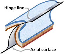
Cylindrical fold with axial surface not a plane.[1]
Folds are classified by their size, fold shape, tightness, dip of the axial plane.[2]
Fold terminology in two dimensions
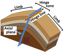
Looking at a fold surface in profile the fold can be divided into hinge and limb portions. The limbs are the flanks of the fold and the hinge is where the flanks join together. The hinge point is the point of minimum radius of curvature for a fold. The crest of the fold is the highest point of the fold surface, and the trough is the lowest point. The inflection point of a fold is the point on a limb at which the concavity reverses, on regular folds this is the mid-point of the limb.
Fold terminology in three dimensions
The hinge points along an entire folded surface form a hinge line, which can be either a crest line or a trough line. The trend and plunge of a linear hinge line gives you information about the orientation of the fold. To more completely describe the orientation of a fold, one must describe the axial surface. The axial surface is the surface defined by connecting all the hinge lines of stacked folding surfaces. If the axial surface is a planar surface then it is called the axial plane and can be described by the strike and dip of the plane. An axial trace is the line of intersection of the axial surface with any other surface (ground, side of mountain, geological cross-section).
Finally, folds can have, but don’t necessarily have a fold axis. A fold axis, “is the closest approximation to a straight line that when moved parallel to itself, generates the form of the fold.” (Davis and Reynolds, 1996 after Donath and Parker, 1964; Ramsay 1967). A fold that can be generated by a fold axis is called a cylindrical fold. This term has been broadened to include near-cylindrical folds. Often, the fold axis is the same as the hinge line.[3][4]
Fold shape
It is necessary to convey a sense of the shape of the fold. A fold can be shaped as a chevron, with planar limbs meeting at an angular axis, as cuspate with curved limbs, as circular with a curved axis, or as elliptical with unequal wavelength.
Fold tightness
Fold tightness is defined by the angle between the fold's limbs, called the interlimb angle. Gentle folds have an interlimb angle of between 180° and 120° , open folds range from 120° to 70°, Close folds from 70° to 30°, tight folds from 30° to 0° ,[5] and isoclinal folds have an interlimb angle of between 10° and zero, with essentially parallel limbs.
Fold symmetry
Not all folds are equal on both sides of the axis of the fold. Those with limbs of relatively equal length are termed symmetrical, and those with highly unequal limbs are asymmetrical. Asymmetrical folds generally have an axis at an angle to the original unfolded surface they formed on.
Deformation style classes
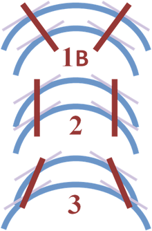
Folds that maintain uniform layer thickness are classed as concentric folds. Those that do not are called similar folds. Similar folds tend to display thinning of the limbs and thickening of the hinge zone. Concentric folds are caused by warping from active buckling of the layers, whereas similar folds usually form by some form of shear flow where the layers are not mechanically active. Ramsay has proposed a classification scheme for folds that often is used to describe folds in profile based upon curvature of the inner and outer lines of a fold, and the behavior of dip isogons. that is, lines connecting points of equal dip:[6]
Ramsay classification of folds by convergence of dip isogons (red lines).[7]
Ramsay classification scheme for folds Class Curvature C Comment 1 Cinner > Couter Dip isogons converge 1A Orthogonal thickness at hinge narrower than at limbs 1B Parallel folds 1C Orthogonal thickness at limbs narrower than at hinge 2 Cinner = Couter Dip isogons are parallel: similar folds 3 Cinner < Couter Dip isogons diverge Fold types
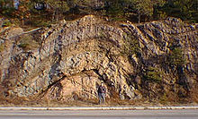
 Recumbent fold, King Oscar Fjord
- Anticline: linear, strata normally dip away from axial center, oldest strata in center.
- Syncline: linear, strata normally dip toward axial center, youngest strata in center.
- Antiform: linear, strata dip away from axial center, age unknown, or inverted.
- Synform: linear, strata dip toward axial centre, age unknown, or inverted.
- Dome: nonlinear, strata dip away from center in all directions, oldest strata in center.
- Basin: nonlinear, strata dip toward center in all directions, youngest strata in center.
- Monocline: linear, strata dip in one direction between horizontal layers on each side.
- Chevron: angular fold with straight limbs and small hinges
- Recumbent: linear, fold axial plane oriented at low angle resulting in overturned strata in one limb of the fold.
- Slump: typically monoclinal, result of differential compaction or dissolution during sedimentation and lithification.
- Ptygmatic: Folds are chaotic, random and disconnected. Typical of sedimentary slump folding, migmatites and decollement detachment zones.
- Parasitic: short wavelength folds formed within a larger wavelength fold structure - normally associated with differences in bed thickness[8]
- Disharmonic: Folds in adjacent layers with different wavelengths and shapes[8]
(A homocline involves strata dipping in the same direction, though not necessarily any folding.)
Causes of folding
Folds appear on all scales, in all rock types, at all levels in the crust and arise from a variety of causes.
Layer-parallel shortening
When a sequence of layered rocks is shortened parallel to its layering, this deformation may be accommodated in a number of ways, homogeneous shortening, reverse faulting or folding. The response depends on the thickness of the mechanical layering and the contrast in properties between the layers. If the layering does begin to fold, the fold style is also dependent on these properties. Isolated thick competent layers in a less competent matrix control the folding and typically generate classic rounded buckle folds accommodated by deformation in the matrix. In the case of regular alternations of layers of contrasting properties, such as sandstone-shale sequences, kink-bands, box-folds and chevron folds are normally produced.[9]
Many folds are directly related to faults, associate with their propagation, displacement and the accommodation of strains between neighbouring faults.
Fault bend folding
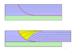
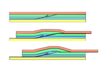
Fault bend folds are caused by displacement along a non-planar fault. In non-vertical faults, the hanging-wall deforms to accommodate the mismatch across the fault as displacement progresses. Fault bend folds occur in both extensional and thrust faulting. In extension, listric faults form rollover anticlines in their hanging walls.[10] In thrusting, ramp anticlines are formed whenever a thrust fault cuts up section from one detachment level to another. Displacement over this higher-angle ramp generates the folding.[11]
Fault propagation folding
Fault propagation folds or tip-line folds are caused when displacement occurs on an existing fault without further propagation. In both reverse and normal faults this leads to folding of the overlying sequence, often in the form of a monocline.[12]
Detachment folding
When a thrust fault continues to displace above a planar detachment without further fault propagation, detachment folds may form, typically of box-fold style. These generally occur above a good detachment such as in the Jura Mountains, where the detachment occurs on middle Triassic evaporites.[13]
Compaction
Folds can be generated in a younger sequence by differential compaction over older structures such as fault blocks and reefs.[14]
Folding in shear zones
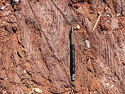
Shear zones that approximate to simple shear typically contain minor asymmetric folds, with the direction of overturning consistent with the overall shear sense. Some of these folds have highly curved hinge lines and are referred to as sheath folds. Folds in shear zones can be inherited, formed due to the orientation of pre-shearing layering or formed due to instability within the shear flow.[15]
Sedimentary folding
Recently deposited sediments are normally mechanically weak and prone to remobilisation.
Slump folding
When slumps form in poorly consolidated sediments they commonly undergo folding, particularly at their leading edges, during their emplacement. The asymmetry of the slump folds can be used to determine paleoslope directions in sequences of sedimentary rocks.[16]
Dewatering
Rapid dewatering of sandy sediments, possibly triggered by seismic activity can cause convolute bedding.[17]
Igneous intrusion
The emplacement of igneous intrusions tends to deform the surrounding country rock. In the case of high-level intrusions, near the Earth's surface, this deformation is concentrated above the intrusion and often takes the form of folding, as with the upper surface of a laccolith.[18]
Flow folding
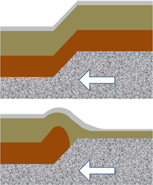
Flow folding: this picture uses artistic license to show the effect of an advancing ramp of rigid rock into compliant layers. Top: low drag by ramp: layers are not altered in thickness; Bottom: high drag: lowest layers tend to crumple.[19]
The compliance of rock layers is referred to as competence: a competent layer or bed of rock can withstand an applied load without collapsing and is relatively strong, while an incompetent layer is relatively weak. When rock behaves as a fluid, as in the case of very weak rock such as rock salt, or any rock that is buried deeply enough, they typically show flow folding (also called passive folding, because little resistance is offered): the strata appear shifted undistorted, assuming any shape impressed upon them by surrounding more rigid rocks. The strata simply serve as markers of the folding.[20] Such folding is also a feature of many igneous intrusions and glacier ice.[21]
Folding mechanisms
Folding of rocks must balance the deformation of layers with the conservation of volume in a rock mass. This occurs by several mechanisms.
Flexural slip
Flexural slip allows folding by creating layer-parallel slip between the layers of the folded strata, which, altogether, result in deformation. The best analogy is bending a phone book, where volume preservation is accommodated by slip between the pages of the book.
Buckling
Typically, folding is thought to occur by simple buckling of a planar surface and its confining volume. The volume change is accommodated by layer parallel shortening the volume, which grows in thickness. Folding under this mechanism is typically of the similar fold style, as thinned limbs are shortened horizontally and thickened hinges do so vertically.
Mass displacement
If the folding deformation cannot be accommodated by flexural slip or volume-change shortening (buckling), the rocks are generally removed from the path of the stress. This is achieved by pressure dissolution, a form of metamorphic process, in which rocks shorten by dissolving constituents in areas of high strain and redepositing them in areas of lower strain. Folds created in this way include examples in migmatites, and areas with a strong axial planar cleavage.
Mechanics of Folding
Folds in rock are formed in relation to the stress field in which the rocks are located and the rheology, or method of response to stress, of the rock at the time at which the stress is applied.
The rheology of the layers being folded determines characteristic features of the folds that are measured in the field. Rocks that deform more easily form many short-wavelength, high-amplitude folds. Rocks that do not deform as easily form long-wavelength, low-amplitude folds.
See also
- Orogeny
- Mountain building
- Thrust fault
Notes
- ^ DD Pollard & RC Fletcher (2005). "Figure 3.14: Geometric attributes of folded geological surfaces". Fundamentals of Structural Geology. Cambridge University Press. p. 92. ISBN 0521839270. http://www.amazon.com/Fundamentals-Structural-Geology-David-Pollard/dp/0521839270#reader_0521839270.
- ^ For a discussion of fold nomenclature, see for example, Robert J. Twiss, Eldridge M. Moores (1992). Structural geology (2nd ed.). Macmillan. pp. 220–221. ISBN 0716722526. http://books.google.com/books?id=14fn03iJ2r8C&pg=PA220.
- ^ Sudipta Sengupta, Subir Kumar Ghosh, Kshitindramohan Naha (1997). Evolution of geological structures in micro- to macro-scales. Springer. p. 222. ISBN 0412750309. http://books.google.com/books?id=sqS2hxRe-nQC&pg=PA222.
- ^ RG Park (2004). "Fold axis and axial plane". Foundations of structural geology (3rd ed.). Routledge. p. 26. ISBN 074875802X. http://books.google.com/books?id=ycASqdxSG3YC&pg=PA26.
- ^ Lisle, Richard J (2004). "Folding". Geological Structures and Maps: 3rd Edition. Elsevier. pp. 33. ISBN 0-7506-5780-4.
- ^ See, for example, R. G. Park (2004). "Figure 3.12: Fold classification based upon dip diagrams". Foundations of structural geology (3rd ed.). Routledge. p. 31 ff. ISBN 074875802X. http://books.google.com/books?id=ycASqdxSG3YC&pg=PA32.
- ^ Neville J. Price, John W. Cosgrove (1990). "Figure 10.14: Classification of fold profiles using dip isogon patterns". Analysis of geological structures. Cambridge University Press. p. 246. ISBN 0521319587. http://books.google.com/books?id=80gYS1IzUWsC&pg=PA246.
- ^ a b Park, R.G. (2004). Foundation of Structural Geology (3 ed.). Routledge. p. 33. ISBN 9780748758029. http://books.google.co.uk/books?id=ycASqdxSG3YC&pg=PA33&dq=parasitic+folds#v=onepage&q=parasitic%20folds&f=false.
- ^ Ramsay, J.G.; Huber M.I. (1987). The techniques of modern structural geology. 2 (3 ed.). Academic Press. pp. 392. ISBN 9780125769228. http://books.google.co.uk/books?id=_hXzNILoSnAC&pg=PA430&lpg=PA430&dq=layer+parallel+shortening+anisotropy+chevron+folds+buckling#v=onepage&q=layer%20parallel%20shortening%20anisotropy%20chevron%20folds%20buckling&f=false. Retrieved 2009-11-01.
- ^ Withjack, M.O.; Schlische (2006). "Models of extensional fault-bend folds". In Buiter S.J.H. & Schreurs G.. Analogue and numerical modelling of crustal-scale processes. Special Publications 253. R.W.. Geological Society, London. pp. 285–305. ISBN 9781862391918. http://books.google.co.uk/books?id=oOMfgdykbAkC&pg=PA298&dq=%22fault+bend+fold%22+extensional+rollover#v=onepage&q=%22fault%20bend%20fold%22%20extensional%20rollover&f=false. Retrieved 2009-10-31.
- ^ Rowland, S.M.; Duebendorfer E.M. & Schieflebein I.M. (2007). Structural analysis and synthesis: a laboratory course in structural geology (3 ed.). Wiley-Blackwell. pp. 301. ISBN 9781405116527. http://books.google.co.uk/books?id=IWnmBEtmg2MC&dq=%22ramp+anticline%22. Retrieved 2009-11-01.
- ^ Jackson, C.A.L.; Gawthorpe R.L. & Sharp I.R. (2006). "Style and sequence of deformation during extensional fault-propagation". Journal of Structural Geology 28 (3). http://www3.imperial.ac.uk/pls/portallive/docs/1/4205901.PDF. Retrieved 2009-11-01.
- ^ Reicherter, K.; Froitzheim, N., Jarosinki, M. (co-ordinators), Badura, J., Franzke, H.-J., Hansen, M., Hübscher, C., Müller, R., Poprawa, P., Reinecker, J., Stackebrandt, W, Voigt,T., von Eynatten, H. & Zuchiewicz, W. (2008). "19. Alpine Tectonics north of the Alps". In McCann, T.. The Geology of Central Europe. Geological Society, London. pp. 1233–1285. ISBN 9781862392649. http://books.google.co.uk/books?id=0KXptTYvKv8C&pg=PA1235&dq=%22detachment+fold%22+jura#v=onepage&q=%22detachment%20fold%22%20jura&f=false. Retrieved 2009-10-31.
- ^ Hyne, N.J. (2001). Nontechnical guide to petroleum geology, exploration, drilling, and production. PennWell Books. pp. 598. ISBN 9780878148233. http://books.google.co.uk/books?id=3A8YIW3uuX0C&pg=PA184&lpg=PA184&dq=compaction+anticline#v=onepage&q=compaction%20anticline&f=false. Retrieved 2009-11-01.
- ^ Carreras, J.; Druguet E. & Griera A. (2005). "Shear zone-related folds". Journal of Structural Geology 27 (7): 1229–1251. http://cat.inist.fr/?aModele=afficheN&cpsidt=17083207. Retrieved 2009-10-31.
- ^ Bradley, D.; Hanson L. (1998). "Paleoslope Analysis of Slump Folds in the Devonian Flysch of Maine". Journal of Geology 106: 305–318. http://alaska.usgs.gov/staff/geology/bradley/bradley_pubs/Paleoslope_Maine_1998.pdf. Retrieved 2009-10-31.
- ^ Nichols, G. (1999). "17. Sediments into rocks: post-depositional processes". Sedimentology and stratigraphy. Wiley-Blackwell. pp. 355. ISBN 9780632035786. http://books.google.co.uk/books?id=F31jOYy-79EC&pg=PA215&lpg=PA215&dq=%22convolute+bedding%22+dewatering#v=onepage&q=%22convolute%20bedding%22%20dewatering&f=false. Retrieved 2009-10-31.
- ^ Orchuela, I.; Lara M.E. & Suarez M. (2003). "Productive Large Scale Folding Associated with Igneous Intrusions: El Trapial Field, Neuquen Basin, Argentina". AAPG abstracts. http://www.searchanddiscovery.com/documents/abstracts/2003barcelona/short/83257.pdf. Retrieved 2009-10-31.
- ^ Arvid M. Johnson, Raymond C. Fletcher (1994). "Figure 2.6". Folding of viscous layers: mechanical analysis and interpretation of structures in deformed rock. Columbia University Press. p. 87. ISBN 0231084846. http://books.google.com/books?id=IOJKgOcjCGQC&pg=PA87#v=onepage&q=&f=false.
- ^ Park, R.G. (2004). Foundations of structural geology (3rd ed.). Routledge. p. 109. ISBN 074875802X. http://books.google.com/books?id=ycASqdxSG3YC&pg=PA109.; RJ Twiss & EM Moores (1992). "Figure 12.8: Passive shear folding". Structural geology (2nd ed.). Macmillan. pp. 241–242. ISBN 0716722526. http://books.google.com/books?id=14fn03iJ2r8C&pg=PA241.
- ^ Hudleston, P.J. (1977). "Simiilar folds, recumbent folds and gravity tectonics in ice and rocks". Journal of Geology 85: 113–122. JSTOR 30068680.
General references
- David D. Pollard, Raymond C. Fletcher (2005). Fundamentals of structural geology. Cambridge University Press. ISBN 0521839270. http://books.google.com/books?id=9atcPwpwgJ0C&printsec=frontcover#v=onepage&q=&f=false.
- Davis, George H.; Reynolds, Stephen J. (1996). "Folds". Structural Geology of Rocks and Regions. New York, John Wiley & Sons. pp. 372–424. ISBN 0-471-52621-5.
- Donath, F.A., and Parker, R.B., 1964, Folds and Folding: Geological Society of America Bulletin, v. 75, p. 45-62
- McKnight, Tom L; Hess, Darrel (2000). "The Internal Processes: Folding". Physical Geography: A Landscape Appreciation. Upper Saddle River, NJ: Prentice Hall. pp. 409–14. ISBN 0-13-020263-0.
- Ramsay, J.G., 1967, Folding and fracturing of rocks: McGraw-Hill Book Company, New York, 560p.
- Lisle, Richard J (2004). "Folding". Geological Structures and Maps: 3rd Edition. Elsevier. pp. 33. ISBN 0-7506-5780-4.
Categories:- Structural geology
- Geological processes
- Geology terminology
Wikimedia Foundation. 2010.

