- River
-
For other uses, see River (disambiguation).
A river is a natural watercourse,[1] usually freshwater, flowing towards an ocean, a lake, a sea, or another river. In a few cases, a river simply flows into the ground or dries up completely before reaching another body of water. Small rivers may also be called by several other names, including stream, creek, brook, rivulet, tributary and rill; there is no general rule that defines what can be called a river, although in some countries or communities a stream may be defined by its size. Many names for small rivers are specific to geographic location; one example is "burn" in Scotland and northeast England. Sometimes a river is said to be larger than a creek,[2] but this is not always the case, because of vagueness in the language.[3]
Rivers are part of the hydrological cycle. Water within a river is generally collected from precipitation through a drainage basin from surface runoff and other sources such as groundwater recharge, springs, and the release of stored water in natural ice and snowpacks (e.g., from glaciers). Potamology is the scientific study of rivers.
Contents
Topography
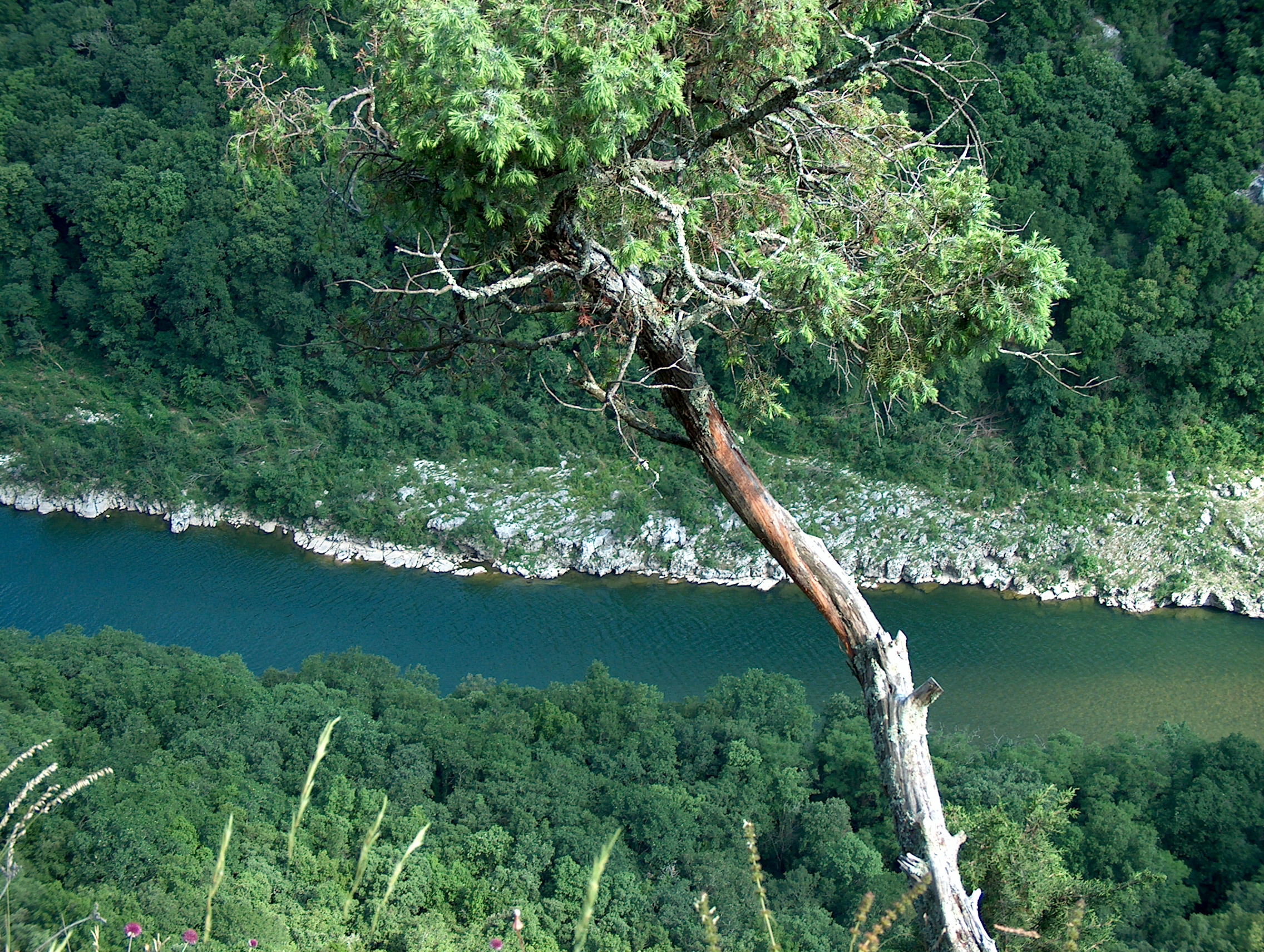
The water in a river is usually confined to a channel, made up of a stream bed between banks. In larger rivers there is also a wider floodplain shaped by flood-waters over-topping the channel. Flood plains may be very wide in relation to the size of the river channel. This distinction between river channel and floodplain can be blurred especially in urban areas where the floodplain of a river channel can become greatly developed by housing and industry. The term upriver refers to the direction leading to the source of the river, which is against the direction of flow. Likewise, the term downriver describes the direction towards the mouth of the river, in which the current flows.
The river channel typically contains a single stream of water, but some rivers flow as several interconnecting streams of water, producing a braided river. Extensive braided rivers are now found in only a few regions worldwide, such as the South Island of New Zealand. They also occur on peneplains and some of the larger river deltas. Anastamosing rivers are similar to braided rivers and are also quite rare. They have multiple sinuous channels carrying large volumes of sediment.
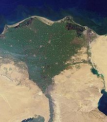 Nile River delta, as seen from Earth orbit. The Nile is an example of a wave-dominated delta that has the classic Greek delta (Δ) shape after which River deltas were named.
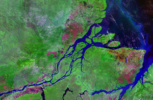
A river flowing in its channel is a source of energy which acts on the river channel to change its shape and form. According to Brahm's law (sometimes called Airy's law), the mass of objects that may be carried away by a river is proportional to the sixth power of the river flow speed. Thus, when the speed of flow increases two times, it can transport 64 times larger (i.e., more massive) objects.[4] In mountainous torrential zones this can be seen as erosion channels through hard rocks and the creation of sands and gravels from the destruction of larger rocks. In U-shaped glaciated valleys, the subsequent river valley can often easily be identified by the V-shaped channel that it has carved. In the middle reaches where the river may flow over flatter land, meanders may form through erosion of the river banks and deposition on the inside of bends. Sometimes the river will cut off a loop, shortening the channel and forming an oxbow lake or billabong. Rivers that carry large amounts of sediment may develop conspicuous deltas at their mouths, if conditions permit. Rivers whose mouths are in saline tidal waters may form estuaries.
Throughout the course of the river, the total volume of water transported downstream will often be a combination of the free water flow together with a substantial contribution flowing through sub-surface rocks and gravels that underlie the river and its floodplain (called the hyporheic zone). For many rivers in large valleys, this unseen component of flow may greatly exceed the visible flow.
Subsurface streams
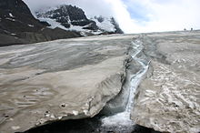
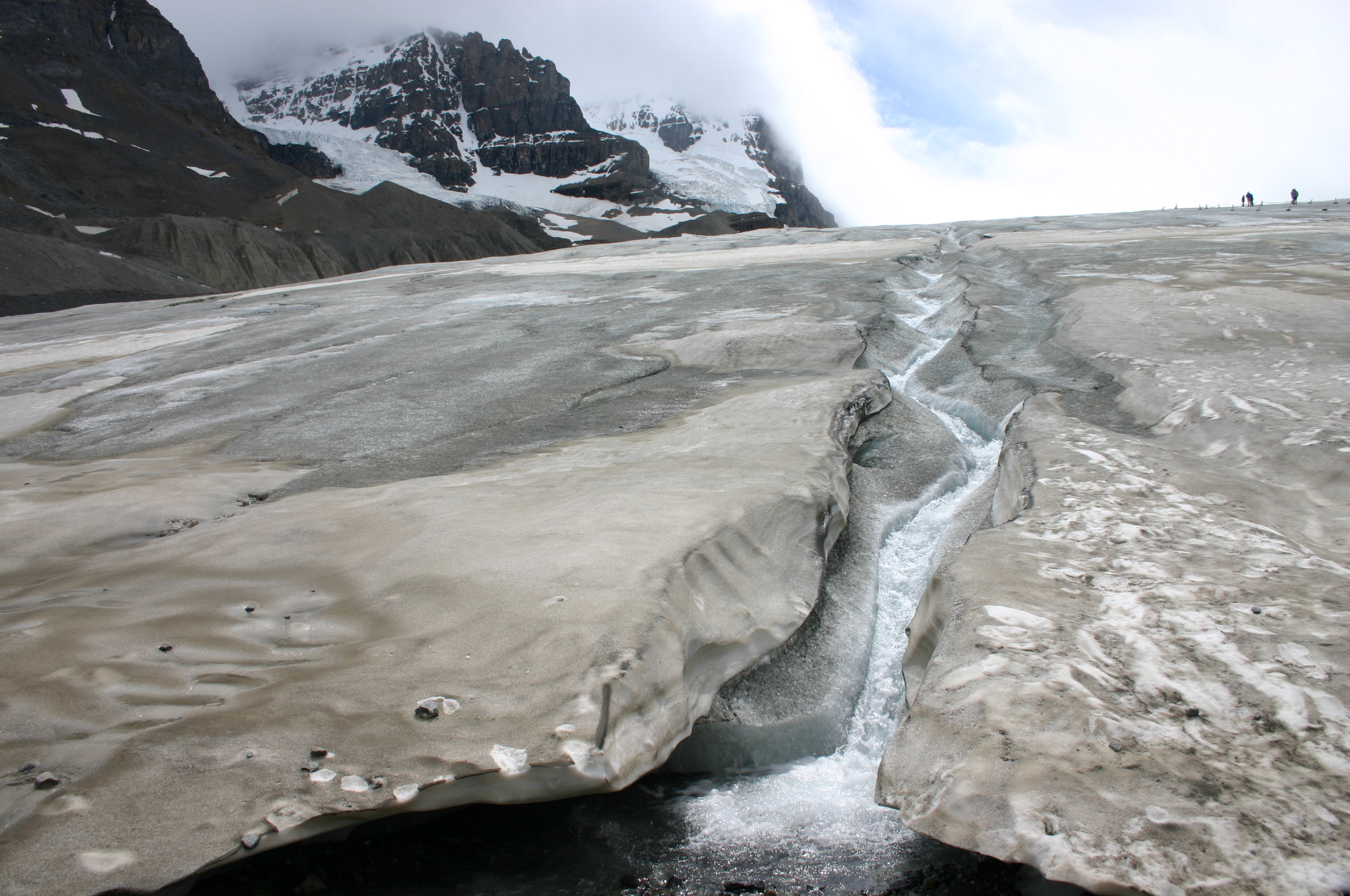
Most but not all rivers flow on the surface. Subterranean rivers flow underground in caves or caverns. Such rivers are frequently found in regions with limestone geologic formations. Subglacial streams are the braided rivers that flow at the beds of glaciers and ice sheets, permitting meltwater to be discharged at the front of the glacier. Because of the gradient in pressure due to the overlying weight of the glacier, such streams can even flow uphill.
Permanence of flow
An intermittent river (or ephemeral river) only flows occasionally and can be dry for several years at a time. These rivers are found in regions with limited or highly variable rainfall, or can occur because of geologic conditions such as having a highly permeable river bed. Some ephemeral rivers flow during the summer months but not in the winter. Such rivers are typically fed from chalk aquifers which recharge from winter rainfall. In the UK these rivers are called Bournes and give their name to place such as Bournemouth and Eastbourne
Classification
Rivers have been classified by many criteria including their topography, their biotic status, their relevance to white water rafting or canoeing activities.
Topographical classification
Rivers can generally be classified as either alluvial, bedrock, or some mix of the two. Alluvial rivers have channels and floodplains that are self-formed in unconsolidated or weakly consolidated sediments. They erode their banks and deposit material on bars and their floodplains. Bedrock rivers form when the river downcuts through the modern sediments and into the underlying bedrock. This occurs in regions that have experienced some kind of uplift (thereby steepening river gradients) or in which a particular hard lithology causes a river to have a steepened reach that has not been covered in modern alluvium. Bedrock rivers very often contain alluvium on their beds; this material is important in eroding and sculpting the channel. Rivers that go through patches of bedrock and patches of deep alluvial cover are classified as mixed bedrock-alluvial.
Alluvial rivers can be further classified by their channel pattern as meandering, braided, wandering, anastomose, or straight. The morphology of an alluvial river reach is controlled by a combination of sediment supply, substrate composition, discharge, vegetation, and bed aggradation.
The work of William Morris Davis at the turn of the 20th century used a classification based on river "age" as a way to characterise rivers.
- Youthful river: A river with a steep gradient that has very few tributaries and flows quickly. Its channels erode deeper rather than wider. Examples include the Brazos, Trinity and Ebro rivers.
- Mature river: A river with a gradient that is less steep than those of youthful rivers and flows more slowly. A mature river is fed by many tributaries and has more discharge than a youthful river. Its channels erode wider rather than deeper. Examples include the Mississippi, Saint Lawrence, Danube, Ohio, Thames and Paraná rivers.
- Old river: A river with a low gradient and low erosive energy. Old rivers are characterized by flood plains. Examples include the Yellow, Ganges, Tigris, Euphrates, Indus and Nile rivers.
- Rejuvenated river: A river with a gradient that is raised by tectonic uplift.
The way in which a river's characteristics vary between the upper course and lower course of a river are summarized by the Bradshaw model. Power-law relationships between channel slope, depth, and width are given as a function of discharge by "river regime".
Biotic classification
There are very many systems of classification based on biotic conditions typically assigning classes from the most oligotrophic or unpolluted through to the most eutrophic or polluted.[5] Other systems are based on a whole eco-system approach such as developed by the New Zealand Ministry for the Environment.[6] In Europe, the requirements of the Water Framework Directive has led to the development of a wide range of classification methods including classifications based on fishery status[7] A system of river zonation used in francophone communities[8][9] divides rivers into three primary zones:
- The crenon is the uppermost zone at the source of the river. It is further divided into the eucrenon (spring or boil zone) and the hypocrenon (brook or headstream zone). These areas are characterized by low temperatures, reduced oxygen content and slow moving water.
- The rhithron is the upstream portion of the river that follows the crenon. It is characterized by relatively cool temperatures, high oxygen levels, and fast, turbulent flow.
- The potamon is the remaining downstream stretch of river. It is characterized by warmer temperatures, lower oxygen levels, slow flow and sandier bottoms.
Whitewater classification
The International Scale of River Difficulty is used to rate the challenges of navigation—particularly those with rapids. Class I is the easiest and Class VI is the hardest.
Stream order classification
The Strahler Stream Order ranks rivers based on the connectivity and hierarchy of contributing tributaries. Headwaters are first order while the Amazon River is twelfth order. Approximately 80% of the rivers and streams in the world are of the first and second order.
Uses
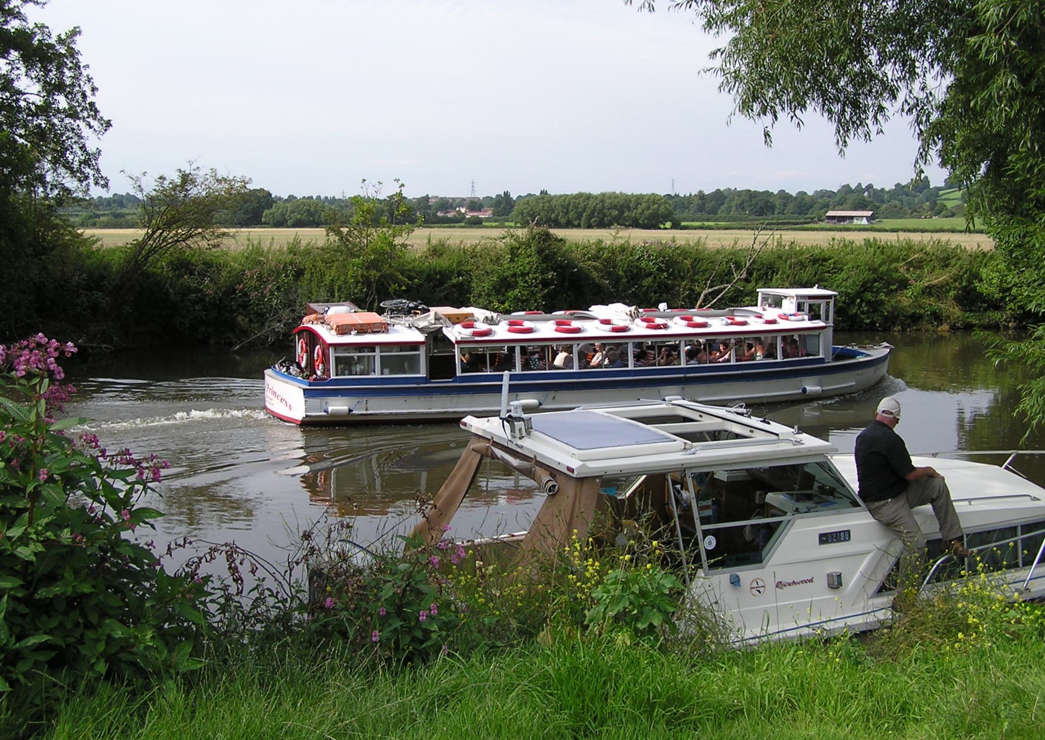
 Leisure activities on the River Avon at Avon Valley Country Park, Keynsham, United Kingdom. A boat giving trips to the public passes a moored private boat.
Rivers have been used as a source of water, for obtaining food, for transport, as a defensive measure, as a source of hydropower to drive machinery, for bathing, and as a means of disposing of waste.
Rivers have been used for navigation for thousands of years. The earliest evidence of navigation is found in the Indus Valley Civilization, which existed in northwestern Pakistan around 3300 BC.[10] Riverine navigation provides a cheap means of transport, and is still used extensively on most major rivers of the world like the Amazon, the Ganges, the Nile, the Mississippi, and the Indus. Since river boats are often not regulated, they contribute a large amount to global greenhouse gas emissions, and to local cancer due to inhaling of particulates emitted by the transports.[11][12]
In some heavily forested regions such as Scandinavia and Canada, lumberjacks use the river to float felled trees downstream to lumber camps for further processing, saving much effort and cost by transporting the huge heavy logs by natural means.
Rivers have been a source of food since pre-history.[13] They can provide a rich source of fish and other edible aquatic life, and are a major source of fresh water, which can be used for drinking and irrigation. It is therefore no surprise to find most of the major cities of the world situated on the banks of rivers. Rivers help to determine the urban form of cities and neighbourhoods and their corridors often present opportunities for urban renewal through the development of foreshoreways such as riverwalks. Rivers also provide an easy means of disposing of waste-water and, in much of the less developed world, other wastes.
Fast flowing rivers and waterfalls are widely used as sources of energy, via watermills and hydroelectric plants. Evidence of watermills shows them in use for many hundreds of years such as in Orkney at Dounby click mill. Prior to the invention of steam power, water-mills for grinding cereals and for processing wool and other textiles were common across Europe. In the 1890s the first machines to generate power from river water were established at places such as Cragside in Northumberland and in recent decades there has been a significant increase in the development of large scale power generation from water, especially in wet mountainous regions such as Norway
The coarse sediments, gravel and sand, generated and moved by rivers are extensively used in construction. In parts of the world this can generate extensive new lake habitats as gravel pits re-fill with water. In other circumstances it can destabilise the river bed and the course of the river and cause severe damage to spawning fish populations which rely on stable gravel formations for egg laying.
In upland rivers, rapids with whitewater or even waterfalls occur. Rapids are often used for recreation, such as whitewater kayaking.
Rivers have been important in determining political boundaries and defending countries. For example, the Danube was a long-standing border of the Roman Empire, and today it forms most of the border between Bulgaria and Romania. The Mississippi in North America and the Rhine in Europe are major east-west boundaries in those continents. The Orange and Limpopo Rivers in southern Africa form the boundaries between provinces and countries along their routes.
Ecosystem
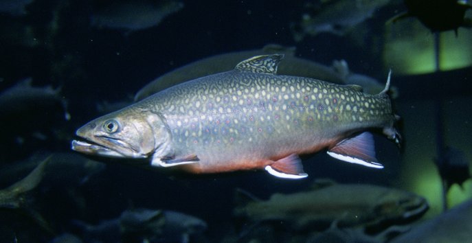
 The brook trout is native to small streams, creeks, lakes, and spring ponds.Main article: River ecosystem
The organisms in the riparian zone respond to changes in river channel location and patterns of flow. The ecosystem of rivers is generally described by the River continuum concept, which has some additions and refinements to allow for spatial (dams, waterfalls) and temporal (extensive flooding). The basic idea is that the river can be described as a system that is continuously changing along its length in the physical parameters, the availability of food particles and the composition of the ecosystem. The food (energy) that is the leftover of the upstream part is being utilized downstream.
The general pattern is that the first order streams contain particulate matter (decaying leaves from the surrounding forests), which is processed there by shredders like Plecoptera larvae. The leftovers of the shredders are utilized by collectors, such as Hydropsyche, and further downstream algae that create the primary production become the main foodsource of the organisms. All changes are gradual and the distribution of each species can be described as a normal curve with the highest density where the conditions are optimal. In rivers succession is virtually absent and the composition of the ecosystem stays fixed in time.
Chemistry
Main article: River chemistryThe chemistry of rivers is complex and depends on inputs from the atmosphere, the geology through which it travels and the inputs from man's activities. The chemistry of the water has a large impact on the ecology of that water for both plants and animals and it also affects the uses that may be made of the river water. Understanding and characterising river water chemistry requires a well designed and managed programme of sampling and analysis
Like many other Aquatic ecosystems, rivers too are under increasing threat of pollution. According to a study of the WWF's Global Freshwater Programme, the 10 most polluted rivers are: Ganges, Indus, Yangtze, Salween-Nu, Mekong-Lancang, Rio Grande/Rio Bravo, La Plata, Danube, Nile-Lake Victoria, and the Murray-Darling.[14]
Brackish water
Further information: Brackish waterSome rivers generate brackish water by having their river mouth in the ocean. This, in effect creates a unique environment in which certain species are found.
Flooding
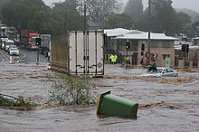 Flash flooding caused by heavy rain falling in a short amount of time
Flooding is a natural part of a river's cycle. The majority of the erosion of river channels and the erosion and deposition on the associated floodplains occur during flood stage. In many developed areas, human activity has changed river channel form, altering different magnitudes and frequencies of flooding. Some examples of this are the building of levees, the straightening of channels, and the draining of natural wetlands. In many cases human activities in rivers and floodplains have dramatically increased the risk of flooding. Straightening rivers allows water to flow more rapidly downstream increasing the risk of flooding places further downstream. Building on flood plains removes flood storage which again exacerbates downstream flooding. The building of levees may only protect the area behind the levees and not those further downstream. Levees and flood-banks can also increase flooding upstream because of back-water pressure as the upstream water has to squeeze between the levees.
Flow
Studying the flows of rivers is one aspect of hydrology.[15]
Direction
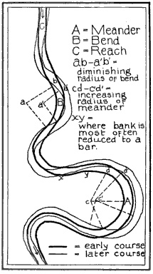
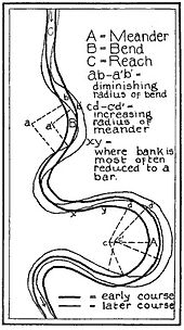 River meandering course
A common misconception is that most, or even all, rivers flow from north to south.[16][17][18] Rivers in fact flow downhill regardless of compass direction. Sometimes downhill is from north to south, but equally it can be from south to north, and usually is a complex meandering path involving all directions of the compass.[19][20][21] Three of the ten longest rivers in the world—the Nile, Yenisei, and Ob—flow north, as do other major rivers such as the Rhine, Mackenzie, and Nelson.
Rivers flowing downhill, from river source to river mouth, do not necessarily take the shortest path. For alluvial streams, straight and braided rivers have very low sinuosity and flow directly down hill, while meandering rivers flow from side to side across a valley. Bedrock rivers typically flow in either a fractal pattern, or a pattern that is determined by weaknesses in the bedrock, such as faults, fractures, or more erodible layers.
Rate
Volumetric flow rate, also called discharge, volume flow rate, and rate of water flow, is the volume of water which passes through a given cross-section of the river channel per unit time. It is typically measured in cubic meters per second (cumec) or cubic feet per second (cfs), where 1 m3/s = 35.51 ft3/s; it is sometimes also measured in litres or gallons per second.
Volumetric flow rate can be thought of as the mean velocity of the flow through a given cross-section, times that cross-sectional area. Mean velocity can be approximated through the use of the Law of the Wall. In general, velocity increases with the depth (or hydraulic radius) and slope of the river channel, while the cross-sectional area scales with the depth and the width: the double-counting of depth shows the importance of this variable in determining the discharge through the channel.
Management
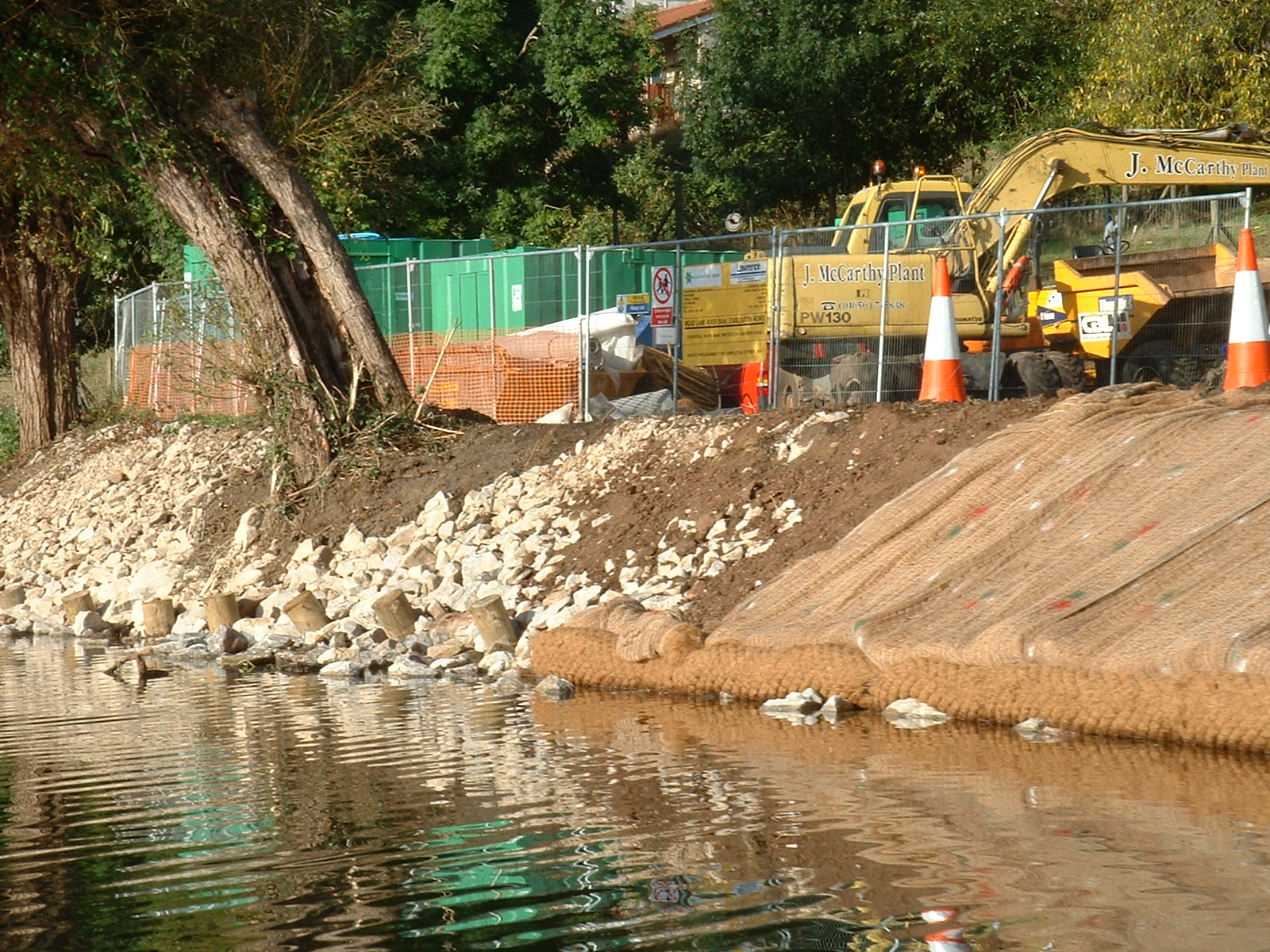
 River bank repairMain article: River engineering
Rivers are often managed or controlled to make them more useful, or less disruptive, to human activity.
- Dams or weirs may be built to control the flow, store water, or extract energy.
- Levees, known as dikes in Europe, may be built to prevent river water from flowing on floodplains or floodways.
- Canals connect rivers to one another for water transfer or navigation.
- River courses may be modified to improve navigation, or straightened to increase the flow rate.
River management is a continuous activity as rivers tend to 'undo' the modifications made by people. Dredged channels silt up, sluice mechanisms deteriorate with age, levees and dams may suffer seepage or catastrophic failure. The benefits sought through managing rivers may often be offset by the social and economic costs of mitigating the bad effects of such management. As an example, in parts of the developed world, rivers have been confined within channels to free up flat flood-plain land for development. Floods can inundate such development at high financial cost and often with loss of life.
Rivers are increasingly managed for habitat conservation, as they are critical for many aquatic and riparian plants, resident and migratory fishes, waterfowl, birds of prey, migrating birds, and many mammals.
See also
- Aqueduct
- Baer's law
- Blackwater river
- Canal
- Drought
- Estuary
- Hack's law
- Hydrology
- List of international border rivers
- List of rivers by discharge
- List of rivers by length
- List of rivers of Africa
- List of rivers of Asia
- List of rivers of Europe
- List of rivers of Oceania
- List of rivers of the Americas
- List of river name etymologies
- List of waterways
- Mainstem (hydrology)
- Playfair's Law
- River civilization
- River continuum concept
- River cruise
- The Riverkeepers (book)
- Rock-cut basin
- Salt tide
- Sediment transport
- Water dispute
- World Rivers Day
Crossings
Transport
References

 An unspecified river in Bangladesh
- ^ River {definition} from Merriam-Webster. Accessed February 2010.
- ^ "WordNet Search: River". The Trustees of Princeton University. http://wordnetweb.princeton.edu/perl/webwn?s=river&sub=Search+WordNet&o2=&o0=1&o7=&o5=&o1=1&o6=&o4=&o3=&h=. Retrieved 2009-10-02.
- ^ "Domestic Names: Frequently Asked Question (FAQs), #17". United States Geological Survey. http://geonames.usgs.gov/domestic/faqs.htm. Retrieved 2009-10-02.
- ^ Garde, R. J. (1995). History of fluvial hydraulics. New Age Publishers. pp. 19. ISBN 812240815X. OCLC 34628134.
- ^ SEPA – River Classification scheme
- ^ NZ’s River Environment Classification system (REC)
- ^ Compilation and harmonisation of fish species classification
- ^ J. Illies & L. Botosaneanu (1963). "Problémes et méthodes de la classification et de la zonation éologique des eaux courantes, considerées surtout du point de vue faunistique.". Mitt. int. Ver. theor. angew. Limnol. 12: 1–57.
- ^ Hawkes, H.A. (1975). River zonation and classification. Blackwell. pp. 312–374.
- ^ Panda.org
- ^ Michel Meybeck (1993). "Riverine transport of atmospheric carbon: Sources, global typology and budget". Water, Air, & Soil Pollution 70 (1–4): 443–463. doi:10.1007/BF01105015.
- ^ Achim Albrecht (2003). "Validating riverine transport and speciation models using nuclear reactor-derived radiocobalt". Journal of Environmental Radioactivity (Elsevier Science Ltd) 66 (3): 295–307. doi:10.1016/S0265-931X(02)00133-9. PMID 12600761.
- ^ NMP.org
- ^ Top 10 most polluted rivers
- ^ Cristi Cave. "How a River Flows". Stream Biology and Ecology. http://chamisa.freeshell.org/flow.htm.
- ^ "Children's Misconceptions about Science". Operation Physics, American Institute of Physics. September 1998. http://amasci.com/miscon/opphys.html.
- ^ William C. Philips (February 1991). "Earth Science Misconceptions". http://k12s.phast.umass.edu/~nasa/misconceptions.html.
- ^ Gregory Vogt (2007). The Lithosphere: Earth's Crust. Twenty-First Century Books. pp. 61. ISBN 9780761328384.
- ^ Matt Rosenberg (2006-06-08). "Do All Rivers Flow South?". About.com. http://geography.about.com/b/a/257582.htm.
- ^ Matt Rosenberg. "Rivers Flowing North: Rivers Only Flow Downhill; Rivers Do Not Prefer to Flow South". About.com. http://geography.about.com/od/learnabouttheearth/a/northrivers.htm.
- ^ Nezette Rydell (1997-03-16). "Re: What determines the direction of river flow? Elevation, Topography,Gravity??". Earth Sciences. http://www.madsci.org/posts/archives/mar97/858609276.Es.r.html.
Further reading
- Jeffrey W. Jacobs. "Rivers, Major World". Water Encyclopaedia. http://www.waterencyclopedia.com/Re-St/Rivers-Major-World.html.
- Luna B. Leopold (1994). A View of the River. Harvard University Press. ISBN 0674937325. OCLC 28889034. ISBN. — a non-technical primer on the geomorphology and hydraulics of water.
External links
- River Network - Connecting people, saving rivers (Environmental organization)
Categories:- Rivers
- Fluvial landforms
- Geomorphology
- Sedimentology
- Water streams


Wikimedia Foundation. 2010.