- Trinity River (California)
Geobox River
name = Trinity River
native_name =
other_name =
other_name1 =
image_size =
image_caption =
country =United States
country1 =
state =California
state1 =
region =
region1 =
district =
district1 =
city =
city1 =
length_imperial = 130
length_note =
watershed_imperial = 2853
watershed_note = [http://pubs.usgs.gov/wdr/2004/wdr-ca-04-2/ Water Resources Data - California, Water year 2004, Volume 2] ,USGS ; see pp. 414-415, gage 11530000 Trinity River at Hoopa, CA]
discharge_location = Hoopa, CA
discharge_imperial = 4858
discharge_max_imperial = 168000
discharge_min_imperial = 244
discharge_note =
discharge1_location =
discharge1_imperial =
source_name = Scott Mountains
source_location =
source_district =
source_region = Trinity County
source_state =
source_country =
source_lat_d = 41
source_lat_m = 19
source_lat_s = 53
source_lat_NS = N
source_long_d = 122
source_long_m = 33
source_long_s = 9
source_long_EW = W
source_coordinates_note =Gnis|236551|Trinity River,USGS GNIS ]
source_elevation_imperial = 5550
source_elevation_note =Google Earth elevation forGNIS coordinates. Retrieved on February 3, 2008.]
mouth_name = Klamath River
mouth_location = Weitchpec
mouth_district =
mouth_region =
mouth_state =
mouth_country =
mouth_lat_d = 41
mouth_lat_m = 11
mouth_lat_s = 5
mouth_lat_NS = N
mouth_long_d = 123
mouth_long_m = 42
mouth_long_s = 31
mouth_long_EW = W
mouth_coordinates_note =
mouth_elevation_imperial = 190
mouth_elevation_note =
tributary_left = South Fork Trinity River
tributary_left1 =
tributary_left2 =
tributary_right =New River
tributary_right1 =
free_name =
free_value =
map_size = 300
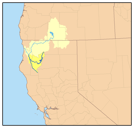
map_caption = Map of the Trinity River and Klamath River watersheds. The Trinity River is shown in dark blue, with its watershed highlighted in dark yellow. The South Fork Trinity River extends southward, while the main Trinity River curves east then north.The Trinity River is the longest tributary of theKlamath River , approximately convert|130|mi|km|0|lk=on long, in northwesternCalifornia in theUnited States . It drains an area of theCoast Ranges , including the southernKlamath Mountains , northwest of theSacramento Valley . Considered especially scenic, along most of its course it flows swiftly through tightcanyon s and mountain meadows.Description
It rises in northeastern Trinity County, in the
Shasta-Trinity National Forest along the east side of theScott Mountains , a subrange of the Klamath Mountains. It flows SSW along the west side of theTrinity Mountains intoTrinity Lake (convert|20|mi|km|0 long) formed on the river by theTrinity Dam , then immediately into the smallerLewiston Lake , formed by theLewiston Dam at Lewiston. From the reservoir it flows generally WNW past Weaverville and along the southern side of theTrinity Alps . It receives the New River from the north at Burnt Ranch and the South Fork Trinity River from the south along the Humboldt-Trinity county line. From the confluence with the South Fork it flows generally NNW through the Hoopa Valley Indian Reservation and joins the Klamath from the south in northern Humboldt County at Weitchpec, approximately convert|20|mi|km|0 from the Pacific coast. Both Trinity Lake and Lake Lewiston are withinWhiskeytown-Shasta-Trinity National Recreation Area .The river has been the scene of placer gold mining, including large-scale
hydraulic mining , since the days of theCalifornia Gold Rush . The river's swift current make it a popular destination forwhitewater rafting andkayak ing. The river is also known for its runs ofsalmon and steelhead maintained in part by hatcheries. In1981 theUnited States Congress designated the entire river downstream from the Lewiston Dam to its mouth on the Klamath, as well as portions of the river's tributaries, as theTrinity Wild and Scenic River .Jerry García 's father drowned in the river.References
External links
* [http://www.trrp.net/ BOR: Trinity River Restoration Program]
* [http://www.fws.gov/cno/arcata/fisheries/tamwg.html Trinity River Adaptive Management Working Group]
* [http://www.fotr.org/ Friends of the Trinity River]
* [http://www.nps.gov/rivers/wsr-trinity.html/ NPS: Trinity Wild and Scenic River]
* [http://www.hoopa-nsn.gov/ Hoopa Valley Tribe]
* [http://www.yuroktribe.org/ Yurok Tribe]
* [http://www.trinitycounty.org/Departments/Planning/natresources2.htm TrinityCounty Planning Department: Natural Resources Division]
* [http://cdec.water.ca.gov/river/trinityStages.html California Department of Water Resources: Trinity River and Tributaries Up-to-Date Flow Data]
* [http://www.usbr.gov/mp/cvo/ BOR: Central Valley Operations Office]
* [http://www.tcrcd.net/ Trinity County Resource Conservation District]
* [http://www.trinityriverrafting.com/ Trinity River Rafting]
Wikimedia Foundation. 2010.