- Nelson River
-
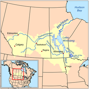
Nelson River River First Nations people on the Nelson River, 1878Country Canada Province Manitoba Source Lake Winnipeg Mouth Hudson Bay - coordinates 57°5′5″N 92°30′8″W / 57.08472°N 92.50222°W [1] Length 2,575 km (1,600 mi) [2] Basin 892,300 km2 (344,500 sq mi) [3] Discharge - average 2,370 m3/s (83,696 cu ft/s) [2] The Nelson River is a river of north-central North America, in the Canadian province of Manitoba. Its full length is 2,575 kilometres (1,600 mi), it has mean discharge of 2,370 cubic metres per second (84,000 cu ft/s), and has a drainage basin of 892,300 square kilometres (344,500 sq mi), of which 180,000 square kilometres (69,000 sq mi) is in the United States.[2] The river drains Lake Winnipeg and runs 644 kilometres (400 mi) before it ends in Hudson Bay.
The river flows through the Canadian Shield out of Playgreen Lake at the northern tip of Lake Winnipeg, and flows through Cross Lake, Sipiwesk Lake, Split Lake and Stephens Lake.
Since it drains Lake Winnipeg, it is the last part of the large Saskatchewan River system, as well as that of the Red River and Winnipeg River. Devils Lake unusual for a glacial lake in being presently closed, also has been known to overflow into the Red River for at least five separate periods since deglaciation[4].
Besides Lake Winnipeg, its primary tributaries include the Grass River, which drains a long area north of Lake Winnipeg, and the Burntwood River, which passes through Thompson, Manitoba.
The river flows into Hudson Bay at Port Nelson (now a ghost town), just north of the Hayes River and York Factory. Other communities upriver from there include Bird, Sundance, Long Spruce, Gillam, Split Lake, Arnot, Cross Lake, and Norway House.
The river was named by Sir Thomas Button, a Welsh explorer from St. Lythans, Glamorganshire, who wintered at its mouth in 1612, after Robert Nelson, a ship's master who died there. The area was fought over for the fur trade, though the Hayes River, whose mouth is near the Nelson's, became the main route inland.
Today, the Nelson River's huge volume and long drop make it useful for generating hydroelectricity. Flooding caused by damming of the river has provoked bitter disputes with First Nations in the past although the Northern Flood Agreement was created in the 1970s to help offset the damages caused by flooding.
Fort Nelson, an historic Hudson's Bay Company trading post, was located at the mouth of the Nelson River at Hudson Bay and was a key trading post in the early 18th century. After his pivotal role in establishing the Hudson's Bay Company, Pierre Esprit Radisson, noted French explorer, was chief director of trade at Port Nelson during one of his sustained periods of service to England. Today, Port Nelson no longer exists. Port Nelson, the abandoned shipping port remains on the opposite side of the river mouth on Hudson Bay.
Contents
See also
- List of longest rivers of Canada
- Nelson River Hydroelectric Project
- List of Manitoba rivers
- Manitoba Hydro
- Nelson River Bipole
References
- ^ "Nelson River". Geographical Names Data Base. Natural Resources Canada. http://geonames.nrcan.gc.ca/search/unique_e.php?id=GATAH&output=xml. Retrieved 2010-11-24.
- ^ a b c Atlas of Canada
- ^ "Canada Drainage Basins". The National Atlas of Canada, 5th edition. Natural Resources Canada. 1985. http://atlas.nrcan.gc.ca/site/english/maps/archives/5thedition/environment/water/mcr4055. Retrieved 24 November 2010.
- ^ Comments on Statements by North Dakotas Senator Kent Conrad in His Letters to the Great Lakes Commission Regarding the Commission’s January 23, 2003, Letter to Senators Urging Support of Senator McCain’s Amendment on the Devil’s Lake Outlet in the Omnibus Appropriations Bill for Fiscal Year 2003
External links
Weblinks
Categories:- Rivers of Manitoba
- Northern Region, Manitoba
- Tributaries of Hudson Bay
Wikimedia Foundation. 2010.


