- Red River of the North
Infobox River
river_name = Red River of the North
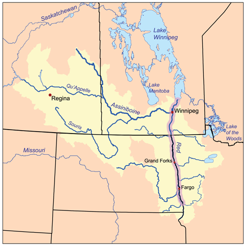
caption = The Red River drainage basin, with the Red River highlighted
origin = confluence of theBois de Sioux River andOtter Tail River
mouth =Lake Winnipeg
basin_countries =United States ,Canada
length = convert|550|mi|km|0|abbr=on
elevation =
mouth_elevation =
discharge =
watershed = km2 to mi2|287500|abbr=es|precision=0 [Cite web|url=http://atlas.nrcan.gc.ca/site/english/learningresources/facts/rivers.html|author=Atlas of Canada|title=Rivers of Canada|accessdate=2008-08-02] The Red River ( _fr. rivière Rouge) is aNorth America n river. Formed by the confluence of the Bois de Sioux and Otter Tail rivers in theUnited States , it flows northward through theRed River Valley and forms the border between theU.S. states ofMinnesota andNorth Dakota before continuing intoManitoba ,Canada . At its mouth the river flows intoLake Winnipeg . The Red River flows through several major urban areas along its path includingFargo-Moorhead andGreater Grand Forks in the United States andWinnipeg in Canada. The Red is about convert|550|mi|km|0 long. [ [http://www.dnr.state.mn.us/canoeing/redriver/index.html Red River of the North] , Minnsota DNR] The US portion is convert|395|mi|km|0 long and the Canadian portion is convert|155|mi|km|0. [ [http://files.dnr.state.mn.us/maps/canoe_routes/red_river_3.pdf Red River Map 3] , Minnesota DNR; map shows the international border atriver mile 155.] The river falls convert|70|m|ft|0 on its trip toLake Winnipeg where it spreads into the vast deltaic wetland known as Netley Marsh. In the United States, the Red River is sometimes called the Red River of the North which helps to distinguish it from the other Red River which is atributary of theMississippi River that forms part of the border betweenTexas andOklahoma . In Canada, the Red has been designated as aCanadian Heritage River .Geography
Along its course, the Red River flows across the flat, fertile flood plain of the ancient glacial
Lake Agassiz . The Red River forms atWahpeton, North Dakota andBreckenridge, Minnesota , passes throughFargo, North Dakota /Moorhead, Minnesota andGrand Forks, North Dakota /East Grand Forks, Minnesota , and then continues on to the province ofManitoba in Canada. Manitoba's capital —Winnipeg — is at the Red's confluence with theAssiniboine River , at a point commonly referred to as The Forks. The Red then flows further north before draining intoLake Winnipeg which is part of theHudson Bay watershed.History
Originally part of
Rupert's Land , the Red was a key river in the early settlement ofCanada , a centre of thefur trade and the Métis people, and the site of theRed River Colony — the primary settlement of which eventually becameWinnipeg ,Manitoba .The River is well known for flooding in spring due to snow runoff, and has been a topic of "paleoflood" study. [ [http://www.gov.mb.ca/iedm/mrd/geo/pflood/index.html Paleofloods in the Red River Basin] ] Although only three major floods are generally talked about since Europeans have settled in the area, in 1826, 1950 and 1997, there have been many other floods of equal size and even larger ones that can be studied due to their effects on the local landforms. [ [http://www.rrbdin.org/about/flood-tables.jsp Major Historical Floods in the Red River Basin] ]
1950 flood
On
May 8 ,1950 the Red River reached its highest level since 1861. Eight dikes protecting Winnipeg gave way and flooded much of the city, turning convert|600|sqmi|km2|0 of farmland into an enormous lake. The city turned to theCanadian Army and theRed Cross for help, and nearly 70,000 people were evacuated from their homes and businesses (which was one of the largest in Canadian history). Four of eleven bridges in the city were destroyed, and damage was estimated at between $600 million and $1 billion.As a result of the floods, a flood control project was started to ensure the same would never happen again. The
Red River Floodway was cause for some derision at the time, as it seemed massively overbuilt and was the largest earth-moving project in the world at the time. The project was completed under-budget, and has been used for at least some flood control twenty times in the thirty-seven years from its completion to 2006. The Floodway has saved an estimated $10 billion (CAD) in flood damages.1997 flood
In April 1997, the Red River rapidly swelled and eventually caused widespread flooding. Damages to the city of
Grand Forks, North Dakota totaledUS$ 2 billion and resulted in the largest civilian evacuation in the United States since the burning of Atlanta during the Civil War. [ [http://www.knightfoundation.com/default.asp?story=news_at_knight/newsletters/37_summer1998/index.html Information about 1997 evacutaion of Grand Forks] - Knight Foundation] In Winnipeg, the Floodway diverted most of the floodwaters around the city, although the surrounding area and some parts of the city were flooded, causingC$ 500 million in damage. In April 2006, another large flood caused theGretna, Manitoba border crossing to close as the water levels rose considerably.The Red River Floodway is now under expansion and is slated for late 2010 at a final cost of more than $665,000,000 CAD.
ee also
*
Red River Valley
*Red River Floodway
*Red River Settlement Notes
External links
* [http://www.ccge.org/ccge/english/Resources/rivers/tr_rivers_redRiver.asp Canadian Council for Geographic Education page with a series of articles on the history of the Red River] .
* [http://gsc.nrcan.gc.ca/floods/redriver/index_e.php Geological Survey of Canada page describing the nature and history of Red River floods] .
* [http://www.dnr.state.mn.us/canoeing/redriver/index.html Minnesota DNR Red River website]
Wikimedia Foundation. 2010.