- Drainage basin
-
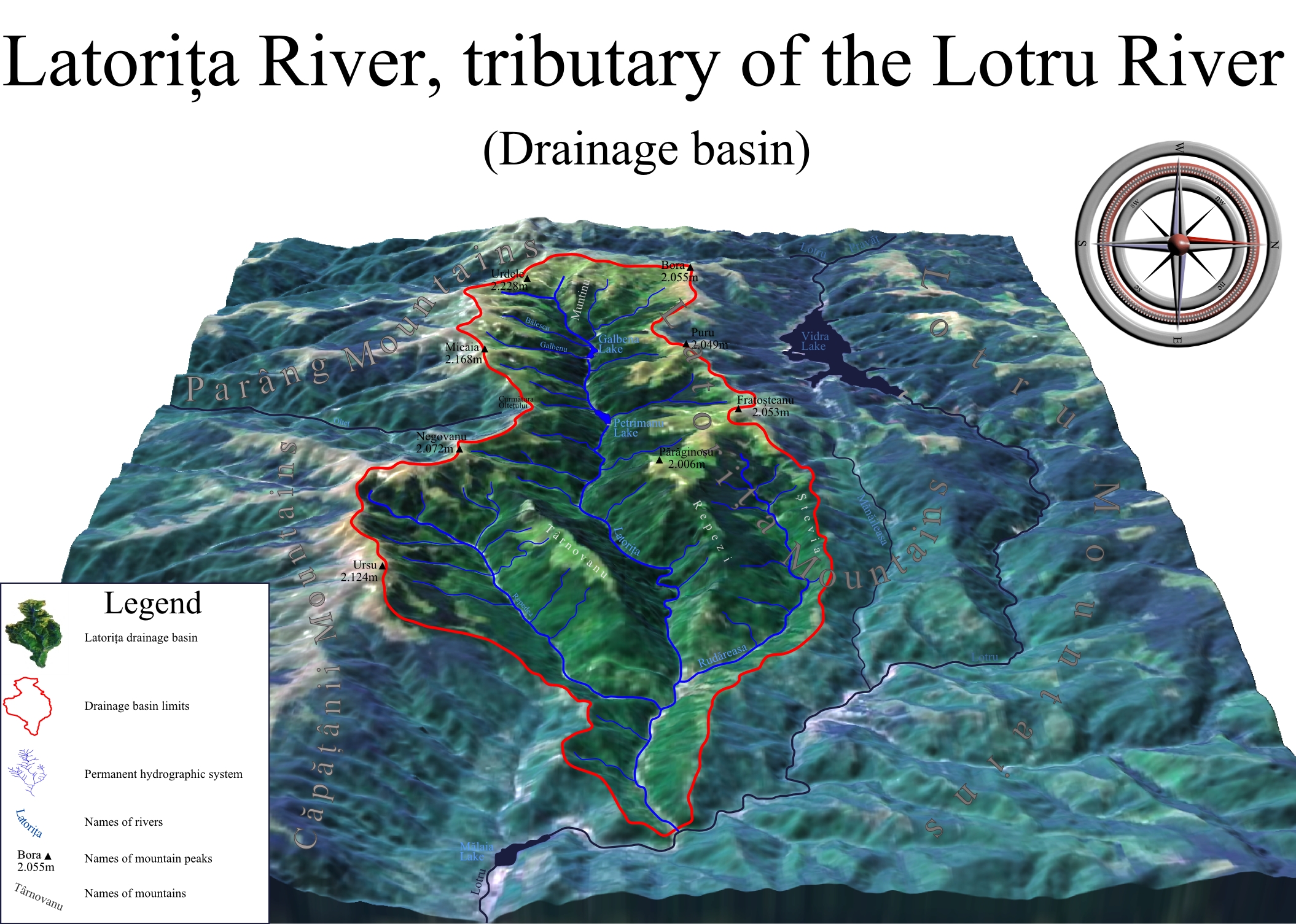
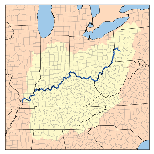
 Example of a drainage basin. The dashed line is the main water divide of the hydrographic basin
A drainage basin is an extent or an area of land where surface water from rain and melting snow or ice converges to a single point, usually the exit of the basin, where the waters join another waterbody, such as a river, lake, reservoir, estuary, wetland, sea, or ocean. In closed drainage basins the water converges to a single point inside the basin, known as a sink, which may be a permanent lake, dry lake, or a point where surface water is lost underground.[1] The drainage basin includes both the streams and rivers that convey the water as well as the land surfaces from which water drains into those channels, and is separated from adjacent basins by a drainage divide.[2]

The drainage basin acts as a funnel by collecting all the water within the area covered by the basin and channelling it to a single point. Each drainage basin is separated topographically from adjacent basins by a geographical barrier such as a ridge, hill or mountain.
Other terms that are used to describe a drainage basin are catchment, catchment area, catchment basin, drainage area, river basin, water basin and watershed.[3] In the technical sense, a watershed refers to a divide that separates one drainage area from another drainage area.[4] However, in the United States and Canada, the term is often used to mean a drainage basin or catchment area itself. Drainage basins drain into other drainage basins in a hierarchical pattern, with smaller sub-drainage basins combining into larger drainage basins.[5]
Drainage basins are similar but not identical to hydrologic units, which are drainage areas delineated so as to nest into a multi-level hierarchical drainage system. Hydrologic units are designed to allow multiple inlets, outlets, or sinks. In a strict sense, all drainage basins are hydrologic units but not all hydrologic units are drainage basins.[1]
The United States Environmental Protection Agency launched the website Watershed Central for the US public to exchange information and locate resources needed to restore local drainage basins in that country.
Contents
Major drainage basins of the world
See also: List of drainage basinsMap
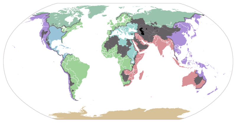
Drainage basins of the principal oceans and seas of the world. Grey areas are endorheic basins that do not drain to the ocean. Ocean basins
There are 354 drainage basins throughout the world[citation needed] in all sorts of places. The following is a list of some of the major ones:
- About 47% of all land in the world drains to the Atlantic Ocean. In North America, surface water drains to the Atlantic via the Saint Lawrence River and Great Lakes basins, the Eastern Seaboard of the United States, the Canadian Maritimes, and most of Newfoundland and Labrador. Nearly all of South America east of the Andes also drains to the Atlantic, as does most of Western and Central Europe, and the greatest portion of western Sub-Saharan Africa. The three major mediterranean seas of the world also flow to the Atlantic:
- The American Mediterranean Sea (the Caribbean Sea and Gulf of Mexico) basin includes most of the US interior between the Appalachian and Rocky Mountain ranges, a small part of the Canadian provinces of Alberta and Saskatchewan, eastern Central America, the islands of the Caribbean and the Gulf, and a small part of northern South America.
- The European Mediterranean Sea basin includes much of northern Africa, east-central Africa (through the Nile), Southern, central, and Eastern Europe, Turkey, and the coastal areas of Israel, Lebanon, and Syria.
- The Arctic Ocean basin drains most of Western and Northern Canada east of the Continental Divide, the north shore of Alaska and parts of North Dakota, South Dakota, Minnesota, and Montana in the United States, the north shore of the Scandinavian peninsula in Europe, and much of central and northern Russia.
- Just over 13% of the land in the world drains to the Pacific Ocean. Its basin includes much of China, southeastern Russia, Japan, Korea, most of Indonesia and Malaysia, the Philippines, all of the Pacific Islands, the northeast coast of Australia, and the western parts of Canada, the United States (including most of Alaska), Central America, and South America.
- The Indian Ocean's drainage basin also comprises about 13% of Earth's land. It drains the eastern coast of Africa, the coasts of the Red Sea and the Persian Gulf, the Indian subcontinent, Burma, and most of Australia.
- The Southern Ocean drains Antarctica. Antarctica comprises approximately eight percent of the Earth's land.
Largest river basins
The three largest river basins (by area), from largest to smallest, are the Amazon basin, the Congo basin, and the Mississippi basin.[6] The three rivers that drain the most water, from most to least, are the Amazon, Congo, and Ganges Rivers.[7]
Endorheic drainage basins
Main article: Endorheic basinEndorheic drainage basins are inland basins that do not drain to an ocean. Around 18% of all land drains to endorheic lakes or seas or sinks. The largest of these consists of much of the interior of Asia, and drains into the Caspian Sea and the Aral Sea. Other endorheic regions include the Great Basin in the United States, much of the Sahara Desert, the watershed of the Okavango River (Kalahari Basin), highlands near the African Great Lakes, the interiors of Australia and the Arabian Peninsula, and parts in Mexico and the Andes. Some of these, such as the Great Basin, are not single drainage basins but collections of separate, adjacent closed basins.
In endorheic bodies of standing water where evaporation is the primary means of water loss, the water is typically more saline than the oceans. An extreme example is the Dead Sea.
Importance of drainage basins
Geopolitical boundaries
Drainage basins have been historically important for determining territorial boundaries, particularly in regions where trade by water has been important. For example, the English crown gave the Hudson's Bay Company a monopoly on the fur trade in the entire Hudson Bay basin, an area called Rupert's Land. Today, bioregional democracy can include agreements of states in a particular drainage basin to defend it. One example of this is the Great Lakes Commission.
Hydrology

In hydrology, the drainage basin is a logical unit of focus for studying the movement of water within the hydrological cycle, because the majority of water that discharges from the basin outlet originated as precipitation falling on the basin. A portion of the water that enters the groundwater system beneath the drainage basin may flow towards the outlet of another drainage basin because groundwater flow directions do not always match those of their overlying drainage network. Measurement of the discharge of water from a basin may be made by a stream gauge located at the basin's outlet.
Rain gauge data is used to measure total precipitation over a drainage basin, and there are different ways to interpret that data. If the gauges are many and evenly distributed over an area of uniform precipitation, using the arithmetic mean method will give good results. In the Thiessen polygon method, the watershed is divided into polygons with the rain gauge in the middle of each polygon assumed to be representative for the rainfall on the area of land included in its polygon. These polygons are made by drawing lines between gauges, then making perpendicular bisectors of those lines form the polygons. The isohyetal method involves contours of equal precipitation are drawn over the gauges on a map. Calculating the area between these curves and adding up the volume of water is time consuming.
Geomorphology
Drainage basins are the principal hydrologic unit considered in fluvial geomorphology. A drainage basin is the source for water and sediment that moves through the river system and reshapes the channel.
Ecology
 The Mississippi River drains the largest area of any U.S. river, much of it agricultural regions. Agricultural runoff and other water pollution that flows to the outlet is the cause of the hypoxic, or dead zone in the Gulf of Mexico.
Drainage basins are important elements to consider also in ecology. As water flows over the ground and along rivers it can pick up nutrients, sediment, and pollutants. Like the water, they get transported towards the outlet of the basin, and can affect the ecological processes along the way as well as in the receiving water source.
Modern usage of artificial fertilizers, containing nitrogen, phosphorus, and potassium, has affected the mouths of watersheds. The minerals will be carried by the watershed to the mouth and accumulate there, disturbing the natural mineral balance. This can cause eutrophication where plant growth is accelerated by the additional material.
Resource management
Further information: Watershed managementBecause drainage basins are coherent entities in a hydrological sense, it has become common to manage water resources on the basis of individual basins. In the U.S. state of Minnesota, governmental entities that perform this function are called watershed districts. In New Zealand, they are called catchment boards. Comparable community groups based in Ontario, Canada, are called conservation authorities. In North America this function is referred to as watershed management. In Brazil, the National Policy of Water Resources, regulated by Act n° 9.433 of 1997, establishes the drainage basin as territorial division of Brazilian water management.
Catchment factors
The catchment is the most significant factor determining the amount or likelihood of flooding.
Catchment factors are: topography, shape, size, soil type and land use (paved or roofed areas). Catchment topography and shape determine the time taken for rain to reach the river, while catchment size, soil type and development determine the amount of water to reach the river.
Topography
Topography determines the speed with which the runoff will reach a river. Clearly rain that falls in steep mountainous areas will reach the river faster than flat or gently sloping areas.
Shape
Shape will contribute to the speed with which the runoff reaches a river. A long thin catchment will take longer to drain than a circular catchment.
Size
Size will help determine the amount of water reaching the river, as the larger the catchment the greater the potential for flooding.
Soil type
Soil type will help determine how much water reaches the river. Certain soil types such as sandy soils are very free draining and rainfall on sandy soil is likely to be absorbed by the ground. However, soils containing clay can be almost impermeable and therefore rainfall on clay soils will run off and contribute to flood volumes. After prolonged rainfall even free draining soils can become saturated, meaning that any further rainfall will reach the river rather than being absorbed by the ground.
Land use
Land use can contribute to the volume of water reaching the river, in a similar way to clay soils. For example, rainfall on roofs, pavements and roads will be collected by rivers with almost no absorption into the groundwater.
See also
- Integrated catchment management
- Interbasin transfer
- International Journal of River Basin Management (JRBM)
- Main stem
- River Basin Management Plans
- River bifurcation
- Time of concentration
Footnotes
- ^ a b "Hydrologic Unit Geography". Virginia Department of Conservation & Recreation. http://www.dcr.virginia.gov/soil_and_water/hu.shtml. Retrieved 21 November 2010.
- ^ "drainage basin". www.uwsp.edu. http://www.uwsp.edu/geo/faculty/ritter/glossary/a_d/drainage_basin.html. Retrieved 2008-02-21.
- ^ Lambert, David (1998). The Field Guide to Geology. Checkmark Books. pp. 130–13. ISBN 0-8160-3823-6.
- ^ "Recommended Watershed Terminology". watershed.org. http://www.watershed.org/?q=node/187. Retrieved 2011-08-26.
- ^ "What is a watershed and why should I care?". university of delaware. http://www.wr.udel.edu/cb/whatwhycare.html. Retrieved 2008-02-11.
- ^ Coupe Jr.; Goolsby, Richard; Donald; Donald A. Goolsby (June 7, 1999). "NASQAN Mississippi River Basin Fact Sheet". Geology. NASQAN. p. 1. http://water.usgs.gov/nasqan/progdocs/factsheets/missfacts/missfs.html. Retrieved 2008-06-24.[dead link]
- ^ Encarta Encyclopedia articles on Amazon River, Congo River, and Ganges Published by Microsoft in computers.
References
- DeBarry,Paul A. (2004). Watersheds: Processes, Assessment and Management. John Wiley & Sons.
External links
- Science week catchment factsheet
- Catchment Modelling Toolkit
- Water Evaluation And Planning System (WEAP) - modeling hydrologic processes in a drainage basin
- eWater CRC
- New Mexico State University - Water Task Force
- Recommended Watershed Terminology
- A detailed map of watersheds in North America
- Science in Your Watershed, USGS
- Studying Watersheds: A Confluence of Important Ideas
- Water Sustainability Project Sustainable water management through demand management and ecological governance, with the POLIS Project at the University of Victoria
- Map of the Earth's primary watersheds, WRI
- What is a watershed and why should I care?
- Cycleau - A project looking at approaches to managing catchments in North West Europe
- American Water Resources Association
- flash animation of how rain falling on to the landscape will drain into a river depending on the terrain
- StarHydro – software tool that covers concepts of fluvial geomorphology and watershed hydrology
- EPA Surf your watershed
- Florida Watersheds and River Basins - Florida DEP
River morphology Large-scale features Drainage basin • Drainage network • Strahler number (stream order) • River valley • River deltaAlluvial rivers Meander • Meander cutoff • Point bar • Cut bank • Riffle • Stream pool • Braided river • Bar (river morphology) • Anabranch • River bifurcation • River channel migration • Oxbow lake • Floodplain • Riparian corridor • Avulsion (river) • Mouth bar • Thalweg • Channel patternBedrock river Bedforms Regional processes Mechanics Playfair's Law • Hack's law • Sediment transport • Water erosion • Deposition (geology) • Exner equationCategory · Portal Categories:- Drainage basins
- Fluvial landforms
- Freshwater ecology
- Geomorphology
- Hydrology
- Rivers
- Water and the environment
- Water streams
- About 47% of all land in the world drains to the Atlantic Ocean. In North America, surface water drains to the Atlantic via the Saint Lawrence River and Great Lakes basins, the Eastern Seaboard of the United States, the Canadian Maritimes, and most of Newfoundland and Labrador. Nearly all of South America east of the Andes also drains to the Atlantic, as does most of Western and Central Europe, and the greatest portion of western Sub-Saharan Africa. The three major mediterranean seas of the world also flow to the Atlantic:


Wikimedia Foundation. 2010.