- Atlantic Ocean
-
"Atlantic", "North Atlantic", "South Atlantic", and "Atlantic Basin" redirect here. For other uses, see Atlantic (disambiguation), North Atlantic (disambiguation), South Atlantic (disambiguation), and Atlantic Basin (disambiguation).
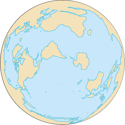
 The Atlantic Ocean, not including Arctic and Antarctic regions

Earth's oceans
(World Ocean)- Arctic Ocean
- Atlantic Ocean
- Indian Ocean
- Pacific Ocean
- Southern Ocean
This video was taken by the crew of Expedition 29 on board the ISS. The pass starts from just north-east of the Island of Newfoundland over the North Atlantic Ocean to central Africa, over South Sudan.The Atlantic Ocean is the second-largest of the world's oceanic divisions. With a total area of about 106,400,000 square kilometres (41,100,000 sq mi),[1] it covers approximately 20% of the Earth's surface and about 26% of its water surface area. The first part of its name refers to Atlas of Greek mythology, making the Atlantic the "Sea of Atlas".
The oldest known mention of "Atlantic" is in The Histories of Herodotus around 450 BC (Hdt. 1.202.4): Atlantis thalassa (Greek: Ἀτλαντὶς θάλασσα; English: Sea of Atlas); see also: Atlas Mountains. The term Ethiopic Ocean, derived from Ethiopia, was applied to the southern Atlantic ocean as late as the mid-19th century.[2] Before Europeans discovered other oceans, the term "ocean" itself was synonymous with the waters beyond the Strait of Gibraltar that we now know as the Atlantic. The early Greeks believed this ocean to be a gigantic river encircling the world.
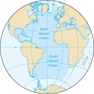
The Atlantic Ocean occupies an elongated, S-shaped basin extending longitudinally between Europe and Africa to the east, and the Americas to the west. As one component of the interconnected global ocean, it is connected in the north to the Arctic Ocean (which is sometimes considered a sea of the Atlantic), to the Pacific Ocean in the southwest, the Indian Ocean in the southeast, and the Southern Ocean in the south. (Other definitions describe the Atlantic as extending southward to Antarctica.) The equator subdivides it into the North Atlantic Ocean and South Atlantic Ocean.
Contents
Geography
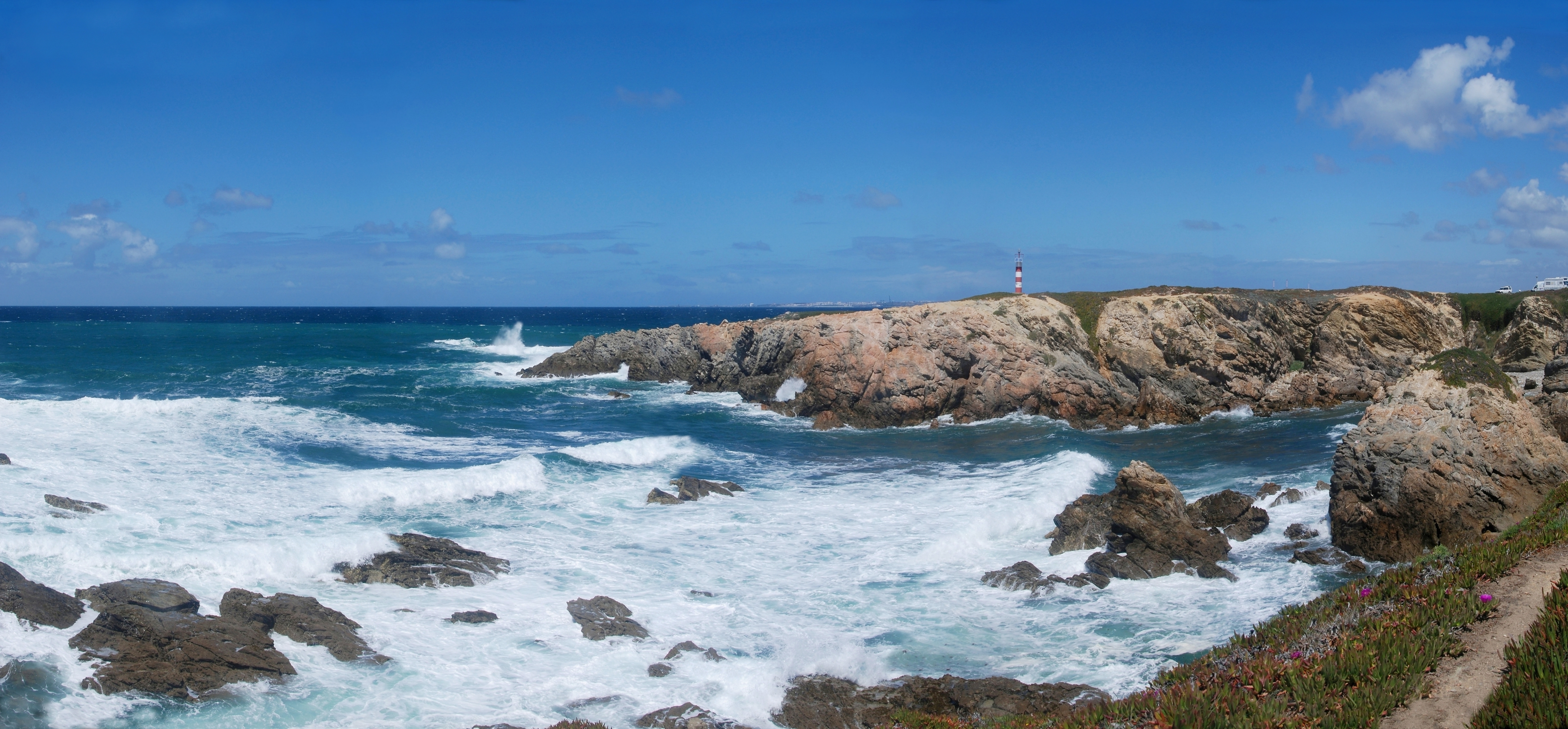
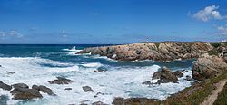 The Atlantic Ocean as seen from the western coast of Portugal
The Atlantic Ocean is bounded on the west by North and South America. It connects to the Arctic Ocean through the Denmark Strait, Greenland Sea, Norwegian Sea and Barents Sea. To the east, the boundaries of the ocean proper are Europe; the Strait of Gibraltar (where it connects with the Mediterranean Sea –one of its marginal seas– and, in turn, the Black Sea) and Africa.
In the southeast, the Atlantic merges into the Indian Ocean. The 20° East meridian, running south from Cape Agulhas to Antarctica defines its border. Some authorities show it extending south to Antarctica, while others show it bounded at the 60° parallel by the Southern Ocean.[3]
In the southwest, the Drake Passage connects it to the Pacific Ocean. The man-made Panama Canal links the Atlantic and Pacific. Besides those mentioned, other large bodies of water adjacent to the Atlantic are the Caribbean Sea; the Gulf of Mexico; Hudson Bay; the Arctic Ocean; the Mediterranean Sea; the North Sea; the Baltic Sea and the Celtic Sea.
Covering approximately 22% of Earth's surface, the Atlantic is second in size to the Pacific. With its adjacent seas, it occupies an area of about 106,400,000 square kilometres (41,100,000 sq mi);[1] without them, it has an area of 82,400,000 square kilometres (31,800,000 sq mi). The land that drains into the Atlantic covers four times that of either the Pacific or Indian oceans. The volume of the Atlantic with its adjacent seas is 354,700,000 cubic kilometers (85,100,000 cu mi) and without them 323,600,000 cubic kilometres (77,640,000 cu mi).
The average depth of the Atlantic, with its adjacent seas, is 3,339 metres (10,955 ft); without them it is 3,926 metres (12,881 ft). The greatest depth, Milwaukee Deep with 8,380 metres (27,490 ft), is in the Puerto Rico Trench. The Atlantic's width varies from 2,848 kilometres (1,770 mi) between Brazil and Sierra Leone to over 6,400 km (4,000 mi) in the south.[citation needed]
Cultural significance
Transatlantic travel played a major role in the expansion of Western civilization into the Americas. It is the Atlantic that separates the "Old World" from the "New World". In modern times, some idioms refer to the ocean in a humorously diminutive way as the Pond, describing both the geographical and cultural divide between North America and Europe, in particular between the English-speaking nations of both continents. Many British people refer to the USA and Canada as "across the pond", and vice versa.[4]
Ocean bottom
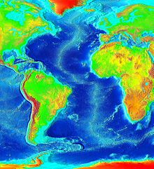 Map that uses color to show ocean depth
The principal feature of the bathymetry (bottom topography) is a submarine mountain range called the Mid-Atlantic Ridge.[5] It extends from Iceland in the north to approximately 58° South latitude, reaching a maximum width of about 1,600 kilometres (990 mi). A great rift valley also extends along the ridge over most of its length. The depth of water at the apex of the ridge is less than 2,700 metres (8,900 ft) in most places, the bottom of the ridge is three times as deep and of course several peaks rise above the water and form islands.[6] The South Atlantic Ocean has an additional submarine ridge, the Walvis Ridge.[7]
The Mid-Atlantic Ridge separates the Atlantic Ocean into two large troughs with depths from 3,700–5,500 metres (12,100–18,000 ft). Transverse ridges running between the continents and the Mid-Atlantic Ridge divide the ocean floor into numerous basins. Some of the larger basins are the Blake, Guiana, North American, Cape Verde, and Canaries basins in the North Atlantic. The largest South Atlantic basins are the Angola, Cape, Argentina, and Brazil basins.
The deep ocean floor is thought to be fairly flat with occasional deeps, abyssal plains, trenches, seamounts, basins, plateaus, canyons, and some guyots. Various shelves along the margins of the continents constitute about 11% of the bottom topography with few deep channels cut across the continental rise.
Ocean floor trenches and seamounts:
- Puerto Rico Trench, in the North Atlantic, is the deepest trench at 8,605 metres (28,232 ft)[8]
- Laurentian Abyss is found off the eastern coast of Canada
- South Sandwich Trench reaches a depth of 8,428 metres (27,651 ft)
- Romanche Trench is located near the equator and reaches a depth of about 7,454 metres (24,455 ft).
Ocean sediments are composed of:
- Terrigenous deposits with land origins, consisting of sand, mud, and rock particles formed by erosion, weathering, and volcanic activity on land washed to sea. These materials are found mostly on the continental shelves and are thickest near large river mouths or off desert coasts.
- Pelagic deposits, which contain the remains of organisms that sink to the ocean floor, include red clays and Globigerina, pteropod, and siliceous oozes. Covering most of the ocean floor and ranging in thickness from 60–3,300 metres (200–10,800 ft) they are thickest in the convergence belts, notably at the Hamilton Ridge and in upwelling zones.
- Authigenic deposits consist of such materials as manganese nodules. They occur where sedimentation proceeds slowly or where currents sort the deposits, such as in the Hewett Curve.
Water characteristics
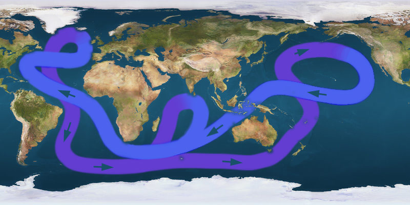
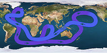 Path of the thermohaline circulation. Purple paths represent deep-water currents, while blue paths represent surface currents.
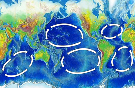
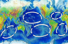 Map of the five major ocean gyres
On average, the Atlantic is the saltiest major ocean; surface water salinity in the open ocean ranges from 33 to 37 parts per thousand (3.3 – 3.7%) by mass and varies with latitude and season. Evaporation, precipitation, river inflow and sea ice melting influence surface salinity values. Although the lowest salinity values are just north of the equator (because of heavy tropical rainfall), in general the lowest values are in the high latitudes and along coasts where large rivers enter. Maximum salinity values occur at about 25° north and south, in subtropical regions with low rainfall and high evaporation.
Surface water temperatures, which vary with latitude, current systems, and season and reflect the latitudinal distribution of solar energy, range from below −2 °C (28 °F). Maximum temperatures occur north of the equator, and minimum values are found in the polar regions. In the middle latitudes, the area of maximum temperature variations, values may vary by 7–8 °C (12–15 °F).
The Atlantic Ocean consists of four major water masses. The North and South Atlantic central waters make up the surface. The sub-Antarctic intermediate water extends to depths of 1,000 metres (3,300 ft). The North Atlantic Deep Water reaches depths of as much as 4,000 metres (13,000 ft). The Antarctic Bottom Water occupies ocean basins at depths greater than 4,000 meters.
Within the North Atlantic, ocean currents isolate the Sargasso Sea, a large elongated body of water, with above average salinity. The Sargasso Sea contains large amounts of seaweed and is also the spawning ground for both the European eel and the American eel.
The Coriolis effect circulates North Atlantic water in a clockwise direction, whereas South Atlantic water circulates counter-clockwise. The south tides in the Atlantic Ocean are semi-diurnal; that is, two high tides occur during each 24 lunar hours. In latitudes above 40° North some east-west oscillation occurs.
Climate
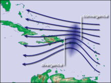 Waves in the trade winds in the Atlantic Ocean—areas of converging winds that move along the same track as the prevailing wind—create instabilities in the atmosphere that may lead to the formation of hurricanes.
Climate is influenced by the temperatures of the surface waters and water currents as well as winds. Because of the ocean's great capacity to store and release heat, maritime climates are more moderate and have less extreme seasonal variations than inland climates. Precipitation can be approximated from coastal weather data and air temperature from water temperatures.
The oceans are the major source of the atmospheric moisture that is obtained through evaporation. Climatic zones vary with latitude; the warmest zones stretch across the Atlantic north of the equator. The coldest zones are in high latitudes, with the coldest regions corresponding to the areas covered by sea ice. Ocean currents influence climate by transporting warm and cold waters to other regions. The winds that are cooled or warmed when blowing over these currents influence adjacent land areas.
The Gulf Stream and its northern extension towards Europe, the North Atlantic Drift, for example, warms the atmosphere of the British Isles and north-western Europe, and the cold water currents contribute to heavy fog off the coast of eastern Canada (the Grand Banks of Newfoundland area) and Africa's north-western coast. In general, winds transport moisture and air over land areas. Hurricanes develop in the southern part of the North Atlantic Ocean.
History
 Animation of showing the separation of Pangaea, which formed the Atlantic Ocean known today
The Atlantic Ocean appears to be the second youngest of the five oceans. It did not exist prior to 130 million years ago, when the continents that formed from the breakup of the ancestral super continent Pangaea were drifting apart from seafloor spreading. The Atlantic has been extensively explored since the earliest settlements along its shores.
The Vikings, the Portuguese, and the Spaniards were the most famous among early explorers. After Columbus, European exploration rapidly accelerated, and many new trade routes were established.
As a result, the Atlantic became and remains the major artery between Europe and the Americas (known as transatlantic trade). Scientific explorations include the Challenger expedition, the German Meteor expedition, Columbia University's Lamont-Doherty Earth Observatory and the United States Navy Hydrographic Office.
Notable crossings
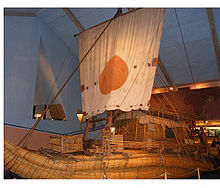 Ra II, a ship built from papyrus, was successfully sailed across the Atlantic by Thor Heyerdahl proving that it was possible to cross the Atlantic from Africa using such boats in early epochs of history.
- In 1000, the Icelander, Leif Ericson was the first European to discover North America's Atlantic coast, including Vinland. The Norse discovery was documented in the 13th century Icelandic Sagas and was corroborated by recent L'Anse aux Meadows archeological evidence.
- In 1003, Thorfinnr Karlsefni led an attempted Viking settlement in North America but was driven off by the natives.
- In 1004, Snorri Thorfinnsson was the first European born on the American continent.
- In 1419 and 1427, Portuguese navigators reached Madeira and Azores, respectively.
- From 1415 to 1488, Portuguese navigators sailed along the Western African coast, reaching the Cape of Good Hope.
- In 1492, Christopher Columbus landed on the island of San Salvador in The Bahamas.
- In 1500, Pedro Álvares Cabral reached Brazil.
- In 1524, Italian explorer Giovanni da Verrazzano discovered the United States of America's east coast.
- In 1764 William Harrison (the son of John Harrison) sailed aboard the HMS Tartar, with the H-4 time piece. The voyage became the basis for the invention of the global system of Longitude.
- In 1858, Cyrus West Field laid the first transatlantic telegraph cable (it quickly failed).
- In 1865 Brunel's ship the SS Great Eastern laid the first successful transatlantic telegraph cable .
- In 1896 Frank Samuelsen and George Harbo from Norway became the first people to ever row across the Atlantic Ocean.
- On April 15, 1912 the RMS Titanic sank after hitting an iceberg with a loss of more than 1,500 lives.[9]
- 1914–1918, the First Battle of the Atlantic took place.
- In 1919, the American NC-4 became the first fixed-wing aircraft (seaplane) to cross the Atlantic (though it made a couple of landings on islands and the sea along the way, and taxied several hundred miles).
- Later in 1919, a British aeroplane piloted by Alcock and Brown made the first non-stop transatlantic flight, from Newfoundland to Ireland.
- In 1921, the British were the first to cross the North Atlantic in an airship.
- In 1922, Sacadura Cabral and Gago Coutinho were the first to cross the South Atlantic in an airship.
- In 1927, Charles Lindbergh made the first solo non-stop transatlantic flight in an aircraft (between New York City and Paris).
- In 1932, Amelia Earhart became the first female to make a solo flight across the Atlantic
- 1939–1945, the Second Battle of the Atlantic. Nearly 3,700 Allied ships were sunk at a cost of 783 German U-boats.[10]
- In 1952, Ann Davison was the first woman to single-handedly sail the Atlantic Ocean.
- In 1969 and 1970 Thor Heyerdahl launched expeditions to cross the Atlantic in boats built from papyrus. He succeeded in crossing the Atlantic from Morocco to Barbados after a two-month voyage of 6,100 km with Ra II in 1970, thus conclusively proving that boats such as the Ra could have sailed with the Canary Current across the Atlantic in prehistoric times.[11]
- In 1975, Fons Oerlemans crossed the Atlantic in 82 days, starting from Safi (Morocco) to Trinidad and Tobago, on a selfmade raft.
- In 1980, Gérard d'Aboville was the first man to cross the Atlantic Ocean rowing.
- In 1984, Five Argentines sail in a 10-meter-long raft made from tree trunks named Atlantis from Canary Islands and after 52 days 3,000 miles (4,800 km) journey arrived to Venezuela in an attempt to prove travelers from Africa may have crossed the Atlantic before Christopher Columbus.[12][13]
- In 1994, Guy Delage was the first man to allegedly swim across the Atlantic Ocean (with the help of a kick board, from Cape Verde to Barbados).
- In 1998, Benoît Lecomte was the first man to swim across the northern Atlantic Ocean without a kick board, stopping for only one week in the Azores.
- In 1999, after rowing for 81 days and 4,767 kilometres (2,962 mi), Tori Murden became the first woman to cross the Atlantic Ocean by rowboat alone when she reached Guadeloupe from the Canary Islands.
Ethiopic Ocean
The Aethiopian Sea, Ethiopic Ocean or Ethiopian Ocean (Okeanos Aithiopos), is an old name for what is now called the South Atlantic Ocean, which is separated from the North Atlantic Ocean by a narrow region between Natal, Brazil and Monrovia, Liberia. The use of this term illustrates a past trend towards referring to the whole continent of Africa by the name Aethiopia. The modern nation of Ethiopia, in northeast Africa, is nowhere near the Ethiopic Ocean, which would be said to lie off the west coast of Africa. The term Ethiopian Ocean sometimes appeared until the mid-19th century.[citation needed]
Economy
The Atlantic has contributed significantly to the development and economy of surrounding countries. Besides major transatlantic transportation and communication routes, the Atlantic offers abundant petroleum deposits in the sedimentary rocks of the continental shelves. The Atlantic hosts the world's richest fishing resources, especially in the waters covering the shelves. The major fish are cod, haddock, hake, herring, and mackerel.
The most productive areas include Newfoundland's Grand Banks, the Nova Scotia shelf, Georges Bank off Cape Cod, the Bahama Banks, the waters around Iceland, the Irish Sea, the Dogger Bank of the North Sea, and the Falkland Banks. Eel, lobster, and whales appear in great quantities. Various international treaties attempt to reduce pollution caused by environmental threats such as oil spills, marine debris, and the incineration of toxic wastes at sea.
Terrain
From October to June the surface is usually covered with sea ice in the Labrador Sea, Denmark Strait, and Baltic Sea. A clockwise warm-water gyre occupies the northern Atlantic, and a counter-clockwise warm-water gyre appears in the southern Atlantic. The Mid-Atlantic Ridge, a rugged north-south centerline for the entire Atlantic basin, first discovered by the Challenger Expedition dominates the ocean floor. This was formed by the vulcanism that also formed the ocean floor and the islands rising from it.
The Atlantic has irregular coasts indented by numerous bays, gulfs, and seas. These include the Norwegian Sea, Baltic Sea, North Sea, Labrador Sea, Black Sea, Gulf of Saint Lawrence, Bay of Fundy, Gulf of Maine, Mediterranean Sea, Gulf of Mexico, and Caribbean Sea.
Islands include Greenland, Iceland, Faroe Islands, Great Britain (including numerous surrounding islands), Ireland, Rockall, Newfoundland, Sable Island, Azores, Madeira, Bermuda, Canary Islands, Caribbean, Cape Verde, São Tomé and Príncipe, Annobón Province, Fernando de Noronha, Rocas Atoll, Ascension Island, Saint Helena, The Islands of Trindad, Tristan da Cunha, Gough Island (Also known as Diego Alvarez), Falkland Islands, Tierra del Fuego, South Georgia Island, South Sandwich Islands, and Bouvet Island.
Natural resources
The Atlantic harbors petroleum and gas fields, fish, marine mammals (seals and whales), sand and gravel aggregates, placer deposits, polymetallic nodules, and precious stones.
Natural hazards
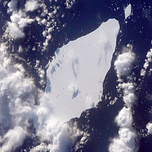 Iceberg A22A in the South Atlantic Ocean
Icebergs are common from February to August in the Davis Strait, Denmark Strait, and the northwestern Atlantic and have been spotted as far south as Bermuda and Madeira. Ships are subject to superstructure icing in the extreme north from October to May. Persistent fog can be a maritime hazard from May to September, as can hurricanes north of the equator (May to December).
The United States' southeast coast has a long history of shipwrecks due to its many shoals and reefs. The Virginia and North Carolina coasts were particularly dangerous.
The Bermuda Triangle is popularly believed to be the site of numerous aviation and shipping incidents because of unexplained and supposedly mysterious causes, but Coast Guard records do not support this belief.
Hurricanes are also a natural hazard in the Atlantic, but mainly in the northern part of the ocean, rarely tropical cyclones form in the southern parts. Hurricanes usually form between June 1 and November 30 of every year. The most notable hurricane in the Atlantic would be Hurricane Katrina in the 2005 season.
Current environmental issues
Endangered marine species include the manatee, seals, sea lions, turtles, and whales. Drift net fishing can kill dolphins, albatrosses and other seabirds (petrels, auks), hastening the fish stock decline and contributing to international disputes.[14] Municipal pollution comes from the eastern United States, southern Brazil, and eastern Argentina; oil pollution in the Caribbean Sea, Gulf of Mexico, Lake Maracaibo, Mediterranean Sea, and North Sea; and industrial waste and municipal sewage pollution in the Baltic Sea, North Sea, and Mediterranean Sea.
In 2005, there was some concern that warm northern European currents were slowing down, but no scientific consensus formed from that evidence.[15]
On June 7, 2006, Florida's wildlife commission voted to take the manatee off the state's endangered species list. Some environmentalists worry that this could erode safeguards for the popular sea creature.
Marine pollution
Main article: Marine pollutionSee also: Ship pollutionMarine pollution is a generic term for the entry into the ocean of potentially hazardous chemicals or particles. The biggest culprits are rivers and with them many agriculture fertilizer chemicals as well as livestock and human waste. The excess of oxygen-depleting chemicals leads to hypoxia and the creation of a dead zone.[16]
Marine debris, which is also known as marine litter, describes human-created waste floating in a body of water. Oceanic debris tends to accumulate at the center of gyres and coastlines, frequently washing aground where it is known as beach litter.
Bordering countries and territories
The states (territories in italics) with a coastline on the Atlantic Ocean (excluding the Baltic and Mediterranean Seas) are:
Europe
Africa
 Morocco
 Angola
 Benin
Benin Bouvet Island
 Côte d'Ivoire
 Cameroon
 Democratic Republic of the Congo
 Republic of the Congo
 Cape Verde
 Western Sahara (claimed by Morocco)
 Spain (Canary Islands)
 Gabon
Gabon Ghana
Ghana Guinea
 Gambia
 Guinea-Bissau
 Equatorial Guinea
 Liberia
 Mauritania
 Namibia
 Nigeria
 Senegal
 Saint Helena, Ascension and Tristan da Cunha
 Sierra Leone
 São Tomé and Príncipe
 Togo
Togo South Africa
South America
Caribbean
 Aruba
Aruba Anguilla
 Antigua and Barbuda
 Bahamas
 Saint Barthélemy
 Barbados
 Cuba
Cuba Curaçao
 Cayman Islands
 Dominica
 Dominican Republic
- France (Martinique and Guadeloupe)
 Grenada
 Haiti
Haiti Jamaica
 Saint Lucia
- Saint Martin
 Montserrat
 Netherlands (Caribbean Netherlands)
 Puerto Rico
 Saint Kitts and Nevis
 Sint Maarten
 Turks and Caicos Islands
 Trinidad and Tobago
 Saint Vincent and the Grenadines
 British Virgin Islands
 United States Virgin Islands
Central and North America
Major ports and harbours
Main article: List of ports and harbours of the Atlantic OceanSee also
- List of islands in the Atlantic Ocean
- Ocean Highway
- Seven Seas
- Aethiopian Sea
- Transatlantic crossing
- Battle of the Atlantic
- Borders of the oceans#Atlantic Ocean
- Gulf Stream shutdown
- History of the Atlantic Ocean articles
- Shipwrecks in the Atlantic Ocean
- Atlantic hurricanes
References
- ^ a b "The New Encyclopaedia Britannica", Volume 2, Encyclopaedia Britannica, 1974. p.294
- ^ George Ripley; Charles Anderson Dana (1873). The American cyclopaedia: a popular dictionary of general knowledge. Appleton. pp. 69–. http://books.google.com/books?id=ROQXAQAAIAAJ&pg=PA69. Retrieved 15 April 2011.
- ^ Limits of Oceans and Seas. International Hydrographic Organization Special Publication No. 23, 1953.
- ^ Example: BBC Click – Episode 04 April 2009
- ^ Kenneth Hsu (1992) Challenger at Sea, Princeton, Princeton University Press, ISBN 0691087350 p. 57
- ^ Kenneth Hsu The Mediterranean Was a Desert, ISBN 0691024065 illustration 13.
- ^ National Geographic Atlas of the World: Revised Sixth Edition, National Geographic Society, 1992
- ^ Milwaukee Deep. sea-seek.com
- ^ Jill Lawless Last Titanic survivor sells mementos. Associated Press. October 16, 2008
- ^ "Introduction" U-Boat Operations of the Second World War—Vol 1 by Wynn, Kenneth, 1998 p. 1
- ^ Ryne, Linn. Voyages into History. Retrieved 2008-01-13.
- ^ 5 cross Atlantic in tiny raft. News.google.com. 12 July 1984 Retrieved on 2011-10-27.
- ^ Expedicion Atlantis (Spanish)
- ^ Problems and Prospects for the Pelagic Driftnet. animallaw.info. Retrieved on 2011-10-27.
- ^ Atlantic Ocean's 'Heat Engine' Chills Down by Christopher Joyce. All Things Considered, National Public Radio, 30 Nov, 2005.
- ^ Sebastian A. Gerlach "Marine Pollution", Springer, Berlin (1975)
Bibliography
- Simon Winchester. Atlantic: A Vast Ocean of a Million Stories. HarperCollins, 2010. ISBN 9780007341375 [Alternative title: Atlantic: The Biography of an Ocean]
- Much of this article originated from the public domain site http://oceanographer.navy.mil/atlantic.html (dead link)
External links
- LA Times special Altered Oceans
- Oceanography Image of the Day, from the Woods Hole Oceanographic Institution
- National Oceanic and Atmospheric Administration
- NOAA In-situ Ocean Data Viewer Plot and download ocean observations
- Atlantic Ocean entry at The World Factbook
- 0°N 30°W / 0°N 30°WCoordinates: 0°N 30°W / 0°N 30°W
- Oceans at the Open Directory Project
- http://www.cartage.org.lb/en/themes/geoghist/histories/history/hiscountries/A/atlanticocean.html
- http://www.mnsu.edu/emuseum/information/oceans/atlantic.html
Regions of the world 
Africa Northern · Sub-Saharan (Central · Southern · Western · Eastern) 
Oceania Australasia (Australia) · Melanesia · Micronesia · Polynesia 
America North (Northern • Middle • Central • Caribbean) · South (Southern • Northern • Western) · Anglo · Latin 
Polar Arctic · Antarctic 
Asia Central · Eastern (Northeastern) · Northern · Southeastern · Southern (Indian subcontinent) · Western (Middle East) 
Oceans World · Arctic · Atlantic · Indian · Pacific · Southern 
Europe Central · Eastern · Northern · Southeastern · Southern · Western Seas List of seas Related Continents of the world · List of seas · Physical EarthCategories:- Atlantic Ocean
- History of the Atlantic Ocean


Wikimedia Foundation. 2010.