- Greenland Sea
-
Greenland Sea 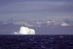
Basin countries Greenland, Iceland, Norway Surface area 1,205,000 km2 (465,300 sq mi) Average depth 1,444 m (4,738 ft) Max depth 4,846 m (15,899 ft) Water volume 1,747,250 km3 (419,000 cu mi) References [1][2] The Greenland Sea is a body of water that borders Greenland to the west, the Svalbard archipelago to the east, Fram Strait and the Arctic Ocean to the north, and the Norwegian Sea and Iceland to the south. The Greenland Sea is often defined as part of the Arctic Ocean,[1][2][3] sometimes as part of the Atlantic Ocean. [4] However, definitions of the Arctic Ocean and its seas tend to be imprecise or arbitrary. In general usage the term "Arctic Ocean" would exclude the Greenland Sea.[5] In oceanographic studies the Greenland Sea is considered part of the Nordic Seas, along with the Norwegian Sea and Iceland Sea. The Nordic Seas are the main connection between the Arctic and Atlantic oceans and, as such, could be of great significance in a possible shutdown of thermohaline circulation. In oceanography the Arctic Ocean and Nordic Seas are often referred to collectively as the "Arctic Mediterranean Sea", a marginal sea of the Atlantic.[6][7][8]
The sea has Arctic climate with regular northern winds and temperatures rarely rising above 0 °C. It previously contained the Odden ice tongue (or Odden) area, which extended eastward from the main East Greenland ice edge in the vicinity of 72–74°N during the winter and acted as a key winter ice formation area in the Arctic. The West Ice forms in winter in the Greenland Sea, north of Iceland, between Greenland and Jan Mayen island. It is a major breeding ground of harp seal and hooded seal that has been used for seal hunting for more than 200 years.
Contents
Extent
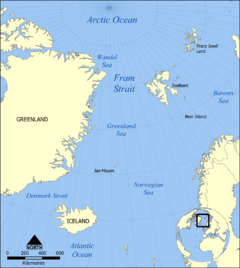
The International Hydrographic Organization defines the limits of the Greenland Sea as follows:[9]
On the North. A line joining the Northernmost point of Spitzbergen [sic] [Svalbard] to the Northernmost point of Greenland.
On the East. The West coast of West Spitzbergen [sic] [island of Spitsbergen].
On the Southeast. A line joining the Southernmost point of West Spitzbergen [sic] to the Northern point of Jan Mayen Island, down the West coast of that island to its Southern extreme, thence a Line to the Eastern extreme of Gerpir (67°05'N, 13°30'W) [NB Actually at 65°05′N 13°30′W / 65.083°N 13.5°W] in Iceland.
On the Southwest. A line joining Straumness (NW extreme of Iceland) to Cape Nansen (68°15′N 29°30′W / 68.25°N 29.5°W) in Greenland.
On the West. The East and Northeast coast of Greenland between Cape Nansen and the northernmost point.
History
While the sea is known for millennia, its first scientific investigations were carried out in 1876–1878 within the Norwegian North-Atlantic Expedition.[10] Since then, many countries, mostly Norway, Iceland and Russia have sent scientific expeditions to the area. The complex water current system was detailed in 1909 by the Fridtjof Nansen.[2]
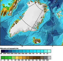 Sea topography
Geography and geology
The Greenland Sea is bounded to the west by the island of Greenland, and to the south by the Denmark Strait and Iceland. To the southeast, behind the Jan Mayen island (Norway) lies the vast expanse of the Norwegian Sea, of which Greenland Sea may be considered an extension. Across the Fram Strait to the northeast, the sea is delimited by the Svalbard archipelago (Norway).
The bottom of the Greenland Sea is a depression bounded to the south by the underwater Greenland-Iceland ridge and to the east by the Mohns Ridge and Knipovich Ridge (parts of the Mid-Atlantic Ridge). To the west, the bottom rises first slowly, but then rapidly toward the wide Greenland coastal strip.[1] Silts fill the submarine hollows and gorges; silty sands, gravel, boulders, and other products of erosion coat the shelves and ridges.[2]
Although the deepest point inside of the sea is 4846 meters, depths down to 5570 meters have been measured in the Molloy Deep of the Fram Strait which connects the sea to the Arctic Ocean on the north.[11]
Major islands of the Greenland Sea include Svalbard archipelago, Edvards, Eila, Godfred Hansens, Île-de-France, Jan Mayen Lynns, Norske and Schnauders. Of those, only the Svalbard islands are inhabited,[12] and Jan Mayen has only temporal military staff. After the League of Nations gave Norway jurisdiction over the island, in 1921 Norway opened the first meteorological station there, which was a subject of contention between Germany and United Kingdom during World War II.[13] Several radio and meteorological stations operate on the island nowadays.
Hydrology, climate and ice
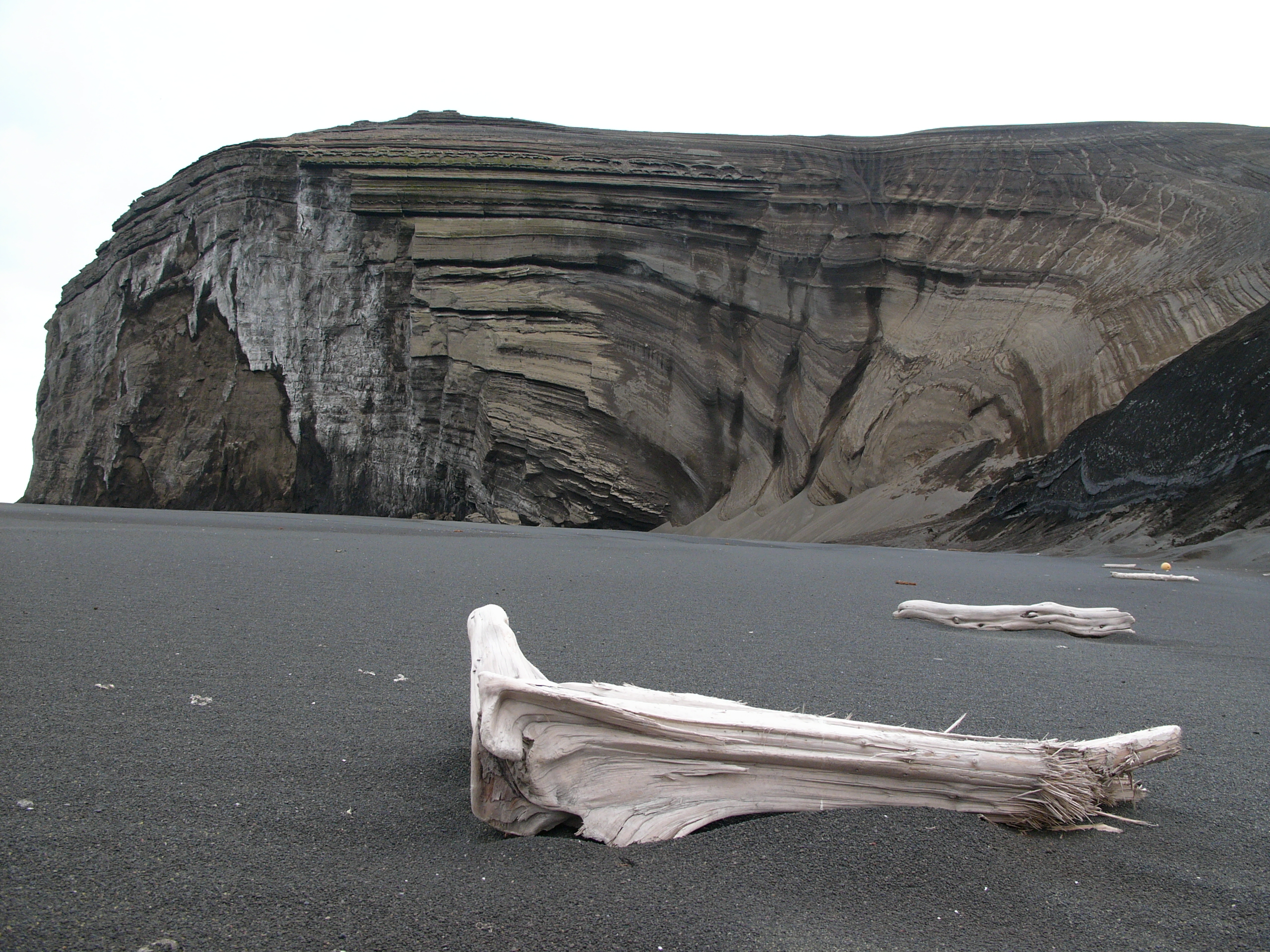
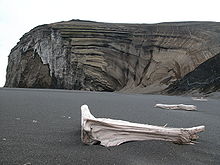 A beach on Jan Mayen island
The climate is Arctic and varies significantly across the vast sea area. Air temperatures fluctuate between –49 °C (–57 °F), near Spitsbergen in winter, and 25 °C (77 °F) off Greenland in summer. Averages are –10 °C (14 °F) in the south and –26 °C (–15 °F) in the north in February, which is the coldest month. The corresponding values for the warmest month, August, are 5 °C (41 °F) in the south and 0 °C (32 °F) in the north.[1][2] The summer is very short, as the number of days per year when the temperature rises above 0 °C varies between 225 on the south to 334 in the north. The annual precipitation is 250 mm (10 in) in the north, but is twice higher in the south.
Northern winds continue through the whole year, cooling the surface water and bringing ice to the south. The average surface water temperature is about –1 °С (30 °F) or lower in the north and 1–2 °C in the south; the corresponding summer temperatures are about 0 °C and 6 °C (43 °F).[2] The bottom water temperatures are below –1 °С. The surface water salinity is 33.0–34.5 parts per thousand (‰) in the eastern and below 32.0‰ in the western parts, increasing to 34.9‰ toward the bottom. The water color is green. Tides are semi-diurnal with the average height of 4.4 m. Together with the water currents, they break up the floating ice sheets and mix various water layers both laterally and along the depth.[1][2]
The progressively colder waters of North Atlantic Current sink in the Arctic Ocean, returning south in the form of cold East Greenland Current, an important part of the Atlantic conveyor belt, which flows along the western part of the sea. Along the eastern part flows the warm Spitsbergen Current, a part of Gulf Stream. Mixtures of cold, fresh water ice melt and the warm, salty Spitsbergen Current may experience cabbeling, and might contribute to thermohaline circulation. The combination of those currents creates a counter-clockwise water flow in the central part of the sea.[1][14][15]
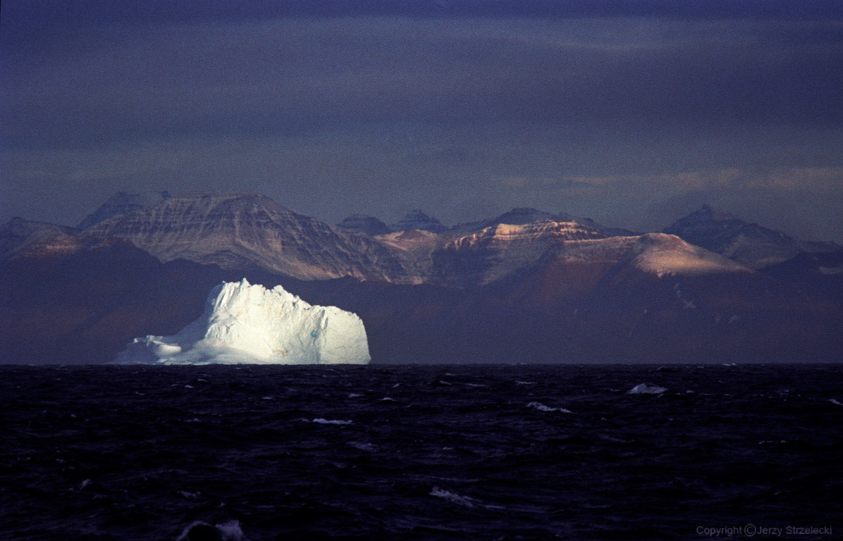
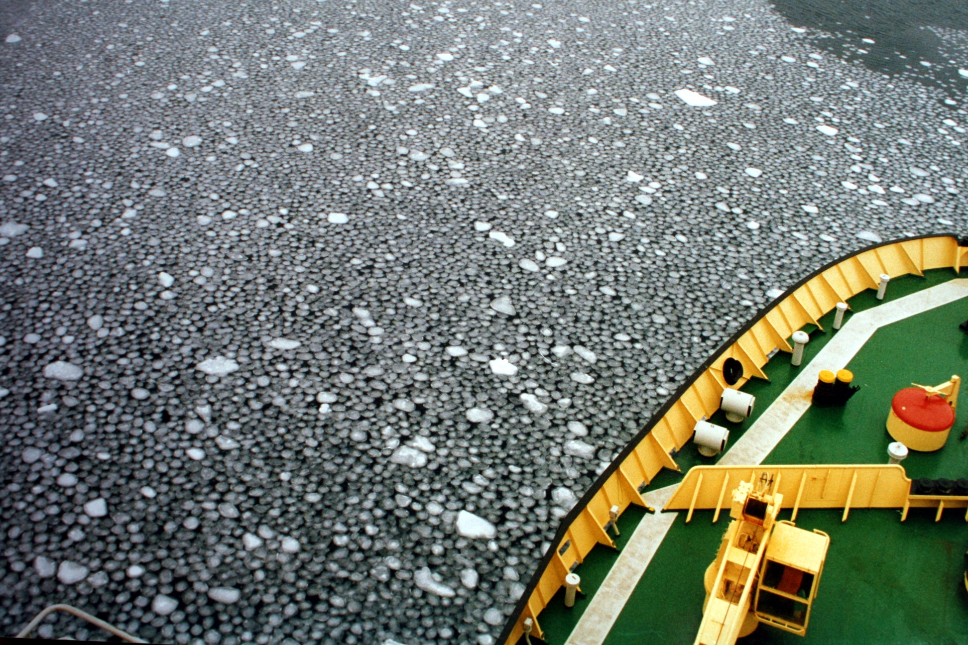
Because of frequent fogs and winds and currents, which continuously transport ice and icebergs through the Greenland Sea to the south, the Greenland Sea has a narrow window for commercial navigation - the ice season starts in October and ends in August. Three types of floating ice are distinguished: Arctic pack ice (several meters thick), sea ice (about a meter thick) and freshwater icebergs.[2]
West Ice
 Frazil ice
In winter, a large area north of Iceland, between Greenland and Jan Mayen, which is called West Ice is covered by continuous ice. It is a major breeding ground for seals, including harp seal, hooded seal and gray seal.[16][17] It was discovered in the early 18th century by British whalers and since late 1750s was used for seal hunting. The hunting was especially intensive in the 19th century, but declined in the 20th century due to hunting restrictions and then declined market demand.[18] Around 5 April 1952, a major storm resulted in disappearance of ships with 79 Norwegian seal hunters on board. Seven other Norwegian seal hunting vessels shipwrecked the same month.[19][20][21][22]
Odden ice tongue
 Pancake ice
The Odden ice tongue or simply the Odden (Odden is Norwegian word for headland) was a key winter ice formation area in the Arctic. It was known for a long time and was encountered by Fridtjof Nansen but was only fully understood with the advent of satellite imagery.[23]
The Odden had a length of about 1,300 km and covered an area of up to 330,000 km² in most years. It extended eastward from the main East Greenland ice edge in the vicinity of 72–74°N during the winter because of the presence of very cold polar surface water in the Jan Mayen Current, which diverts some water eastward from the East Greenland Current at that latitude. Most of the already formed ice continued floating south, driven by the wind, so a cold open water surface was exposed on which new ice formed as frazil ice and pancake ice in the rough seas, producing a giant tongue shape.[24] The salt rejected back into the ocean from this ice formation caused the surface water to become denser and sink, sometimes to great depths (2500 m or more), making this one of the few regions of the ocean where winter convection occurred, which helped drive the entire worldwide system of surface and deep currents known as the thermohaline circulation.[14][15] The Odden Ice Tongue has not been observed since 1997.[25]
Fauna
The Greenland Sea is densely inhabited by the organisms that form the base of the oceanic food chain. Large invertebrates, fish (such as cod, herring, redfish, halibut, and plaice), birds and mammals (including various species of seals, whales, and dolphins) all feed on the smaller invertebrates and small organisms. Mosses, lichens, and scanty bushes around the coasts serve as food to the deer and musk oxen, which in turn are hunted by the polar bear.[2]
References
- ^ a b c d e f "Greenland Sea" (in Russian). Great Soviet Encyclopedia. http://slovari.yandex.ru/%D0%93%D1%80%D0%B5%D0%BD%D0%BB%D0%B0%D0%BD%D0%B4%D1%81%D0%BA%D0%BE%D0%B5%20%D0%BC%D0%BE%D1%80%D0%B5/%D0%91%D0%A1%D0%AD/%D0%93%D1%80%D0%B5%D0%BD%D0%BB%D0%B0%D0%BD%D0%B4%D1%81%D0%BA%D0%BE%D0%B5%20%D0%BC%D0%BE%D1%80%D0%B5/.
- ^ a b c d e f g h i "Greenland Sea". Encyclopedia Britannica on-line. http://www.britannica.com/EBchecked/topic/245318/Greenland-Sea.
- ^ Greenland Sea, MarBEF Data System - European Marine Gazetteer
- ^ Reddy, M. P. M. (2001). Descriptive Physical Oceanography. Taylor & Francis. p. 8. ISBN 9789054107064. http://books.google.com/books?id=2NC3JmKI7mYC&pg=PA8. Retrieved 26 November 2010.
- ^ Serreze, Mark C.; Barry, Roger Graham (2005). The Arctic climate system. Cambridge University Press. p. 19. ISBN 9780521814188. http://books.google.com/books?id=k46foPS-JsIC&pg=PA19. Retrieved 27 November 2010.
- ^ Blindheim, Johan; Østerhus, Svein (2005). "The Nordic Seas, Main Oceanographic Features". In Drange, Helge. The Nordic seas: an integrated perspective : oceanography, climatology, biogeochemistry, and modeling. American Geophysical Union. pp. 11–38. ISBN 9780875904238. http://books.google.com/books?id=gXC09wPIL5MC&pg=PA11. Retrieved 27 November 2010.
- ^ Loeng, Harald (2005). "Chapter 9: Marine Systems". In Symon, Carolyn. Arctic Climate Impact Assessment. Cambridge University Press. pp. 453–493. ISBN 9780521865098. http://books.google.com/books?id=52zXIwAUVa8C&pg=PA493. Retrieved 27 November 2010.
- ^ Meincke, J.; B. Rudels (1997). "The Arctic Ocean–Nordic Seas thermohaline system". ICES Journal of Marine Science 54 (3): 283–299. doi:10.1006/jmsc.1997.0229. ISSN 1054-3139. http://icesjms.oxfordjournals.org/content/54/3/283.short. Retrieved 26 November 2010.
- ^ "Limits of Oceans and Seas, 3rd edition". International Hydrographic Organization. 1953. http://www.iho-ohi.net/iho_pubs/standard/S-23/S23_1953.pdf. Retrieved 6 February 2010.
- ^ Norwegian North-Atlantic Expedition (1876-1878), also [1]
- ^ Soltwedel, T., Miljutina, M., Mokievsky, V., Thistle, D., Vopel, K. (2003). "The meiobenthos of the Molloy Deep (5600 m), Fram Strait, Arctic Ocean". Vie et milieu-life and environment 53 (1): 1–13. http://epic.awi.de/epic/Main?static=yes&page=abstract&entry_dn=T.S2002a.
- ^ Islands of Greenland (Denmark), United Nations Environment Programme (UNEP)
- ^ Rigge, Simon (1980), War in the Outposts, pp. 24–25. Alexandria, Virginia: Time-Life Books.
- ^ a b Hendrik Mattheus van Aken (2007). The oceanic thermohaline circulation: an introduction. pp. 127–130. ISBN 0387366377. http://books.google.com/books?id=dGydMj2madMC&pg=PA127.
- ^ a b Paola Malanotte-Rizzoli, Allan R. Robinson (1994). Ocean processes in climate dynamics: global and mediterranean examples. Springer. pp. 216–217. ISBN 0792326245. http://books.google.com/books?id=UpyuBF4qyJ0C&pg=PA217.
- ^ Geir Johnsen, Egil Sakshaug, Kit Kovacs (2009). Ecosystem Barents Sea. Tapir Academic Press. ISBN 8251924618. http://books.google.com/books?id=2ckz1IGcp-0C&pg=PA456.
- ^ George A. Feldhamer, Bruce Carlyle Thompson, Joseph A. Chapman (2003). Wild mammals of North America: biology, management, and conservation. JHU Press. p. 812. ISBN 0801874165. http://books.google.com/books?id=-xQalfqP7BcC&pg=PA812.
- ^ Farley Mowat (2004). Sea of slaughter. Stackpole Books. p. 341. ISBN 0811731693. http://books.google.com/books?id=Hg9mIvtdxm8C&pg=PA341.
- ^ Fra meteorologihistorien: Orkanen i Vestisen, april 1952 (From meteorology story: Hurricane, West Ice, April 1952), The Norwegian Meteorological Institute, 4 April 2008 (in Norwegian)
- ^ Orkanen i Vestisen april 1952 (in Norwegian)
- ^ Av Bjørn Davidsen Da alarmen gikk i Vestisen, FiskeribladetFiskaren 8 April 2008 (in Norwegian)
- ^ Arnold Farstad: Mysteriet i Vestisen: selfangsttragedien som lamslo nasjonen, ("The West Ice Mystery: The Seal Hunting Tragedy that Stunned the Nation") Samlaget, 2001, ISBN 82-521-5849-8
- ^ Josefino Comiso (2010). Polar Oceans from Space. Springer. pp. 366, 383. ISBN 0387366288. http://books.google.com/books?id=xQyucndLIegC&pg=PA366.
- ^ Carbon Cycling in Arctic Marine Ecosystems: Case Study Young Sound. Museum Tusculanum Press. pp. 20–21. ISBN 8763512785. http://books.google.com/books?id=g-rfPlB-Br8C&pg=PA20.
- ^ "Meltdown: Arctic Wildlife is On the Brink of Catastrophe". http://www.commondreams.org/headlines04/1111-01.htm.
Further reading
- IARC
- Measurements of the Greenland Sea ice extent - University of Illinois Urbana-Champaign
- Greenland Sea ice cover, data animations 1979-1998 - Technical University of Denmark (DTU)
Categories:- Seas of the Arctic Ocean
- Seas of the Atlantic Ocean
- Seas of Greenland
- Seas of Norway


Wikimedia Foundation. 2010.