- Gulf of California
-
For the book by John Steinbeck, see The Log from the Sea of Cortez.
Coordinates: 28°0′N 112°0′W / 28°N 112°W
Islands and Protected Areas of the Gulf of California * UNESCO World Heritage Site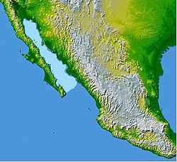
The Gulf of California (highlighted)Country Mexico Type Natural Criteria vii, ix, x Reference 1182 Region ** Latin America and the Caribbean Inscription history Inscription 2005 (29th Session) * Name as inscribed on World Heritage List
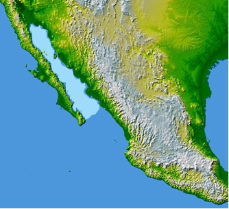
** Region as classified by UNESCOThe Gulf of California (also known as the Sea of Cortez or Sea of Cortés or Vermilion Sea; locally known in the Spanish language as Mar de Cortés or Mar Bermejo or Golfo de California) is a body of water that separates the Baja California Peninsula from the Mexican mainland. It is bordered by the states of Baja California, Baja California Sur, Sonora, and Sinaloa with a coastline of approximately 2,500 mi (4,000 km). Rivers which flow into the Gulf of California include the Colorado, Fuerte, Mayo, Sinaloa, Sonora, and the Yaqui. The gulf's surface area is about 62,000 sq mi (160,000 km2). The name "Gulf of California" predominates on most maps in English today. The name "Sea of Cortés" or Mar de Cortés is the one preferred by most local residents.[citation needed]
The Gulf is thought to be one of the most diverse seas on the planet, and is home to more than 5,000 species of macro-invertebrates.[1] Baja California itself is actually one of the longest, most isolated peninsulas in the world, second only to the Malay Peninsula in Southeast Asia.[2] The Gulf of California is a UNESCO World Heritage Site.
Contents
Geography
The International Hydrographic Organization defines the southern limit of the Gulf of California as: "A line joining Piastla Point (23°38'N) in Mexico, and the Southern extreme of Lower California".[3]
The Gulf of California is 1,126 kilometers (700 mi) long and 48–241 kilometers (30–150 mi) wide, with an area of 177,000 square kilometers (68,000 sq mi), a mean depth of 818.08 meters (2,684.0 ft), and a volume of 145,000 cubic kilometers (34,985 cubic miles).[4]
The Gulf of California includes three faunal regions:
- the Northern Gulf of California
- the Central Gulf of California
- the Southern Gulf of California
One recognized transition zone is termed the Southwestern Baja California peninsula. Transition zones exist between faunal regions, and they usually vary for each individual species. (Faunal regions are distinguishable based on the specific types of animals that are found there.[5])
Geology
Geologic evidence is widely interpreted by geologists as indicating that the Gulf of California came into being around 5.3 million years ago as tectonic forces rifted the Baja California Peninsula off the North American Plate. As part of this process, the East Pacific Rise propagated up the middle of the Gulf along the seabed. This extension of the East Pacific Rise is often referred to as the Gulf of California Rift Zone. The Gulf would extend as far as Indio, California, except for the tremendous delta created by the Colorado River. This delta blocks the sea from flooding the Mexicali and Imperial Valleys. Volcanism dominates the East Pacific Rise. The island of Isla Tortuga is one example of this ongoing volcanic activity.[6]
Weather
The average temperature of the Pacific coast of Baja California is 16–24 °C (61–75 °F).[4] Even though the shores of the Gulf of California are generally sheltered from the continuous wave shock that is experienced by most other North American shores, storms known as a “chubasco” can cause significant damage to shorelines, despite their brevity.[2] Occasionally, the Northern Gulf of California will go through significantly cold winters. The water in the Northern Gulf can sometimes drop below 8 °C, which can lead to a large die-off of marine organisms. The animals that are most susceptible to the large decrease in water temperature include macroscopic algae and plankton.[2]
Fishery
 Giant Pacific Manta Ray
The narrow sea is home to a unique and rich ecosystem. In addition to a wide range of endemic creatures, like the critically endangered Vaquita Marina, it hosts many migratory species, such as the Humpback Whale, California Gray Whale, Killer Whale, Manta Ray and Leatherback Sea Turtle, and the world's largest animal, the Blue Whale. There are unusual resident populations of Fin Whales and Sperm Whales that do not migrate annually. This region has historically been a magnet for world class sport fishing activities, with a rich history of sporting world records.
The region also has a rich history as a commercial fishery. However, the data varies wildly according to the species being studied, and the Gulf's ability to recuperate after years of over fishing remains uncertain. Moreover, changes in terrestrial ecology, such as the vast reduction in flow from the Colorado River into the Gulf, have negatively affected fisheries, particularly in the northern region.
The Gulf of California sustains a large number of marine mammals, many of which are rare, and endangered. Its more than 900 islands are important nesting sites for thousands of seabirds and its waters are a primary breeding, feeding, and nursing grounds for myriad migratory and resident fish species. For decades, the gulf has been a primary source of two of Mexico's leading marine resources, sardines and anchovies. Water pollution is a problem in the Gulf of California, but the more immediate concerns are overfishing and bottom trawling, which destroys eelgrass beds and shellfish.
Efforts by the Mexican government to create conservation zones and Nature reserves have been hampered by lack of enforcement resources as well as a lack of a political consensus on this issue of conservation of the Gulf. This even though significant areas are a UNESCO World Heritage Site. The thousands of miles of coastline are remote and difficult to police, and the politically powerful commercial fishing industry has been slow to embrace even economically viable conservation measures, much less strict measures of conservation. Conservation of the Gulf's fisheries and coastlines is also complicated by a long history of over-capitalization in the sector, and the direct, often negative impacts that conservation measures have on the livelihoods of Mexico's coastal inhabitants. At present, the Mexican government and business interests have promoted a macro-level, tourist development vision for the Gulf, whose impacts on local ecology and society are uncertain.
Coastal communities that are highly reliant on both commercial and sport fishing include San Felipe, San Carlos, Sonora, Cabo San Lucas, La Paz, Loreto, Guaymas, Bahia de Kino, Puerto Penasco, Topolobampo and Mulegé. The well-developed shrimp and sardine fleets of Mazatlán, on the Mexican mainland's Pacific coast, heavily exploit the commercial fisheries of the southern Gulf.
Many marine organisms can only survive within a particular salinity range, which makes salinity a notable factor in determining the types of potentially-commercial organisms found in the Gulf of California. The mean annual ranges of salinity of the Sea of Cortez are between 35 to 35.8 ‰ at the surface.[4] Furthermore, the salinity of the water of the Northern Gulf of California is generally higher than the Central and Southern faunal regions due to the increased amount of evaporation that occurs in that region.[2]
Shores and tides
Three general types of shores found in the Gulf of California include rocky shore, sandy beach, and tidal flat. Some of the rich biodiversity and high endemism that characterizes the Gulf of California and makes it such a hotspot for fishing can be attributed to seemingly insignificant factors, such as the types of rocks that make up a shore. Beaches with softer, more porous rocks (such as Coquina limestone, rhyolites, granite, or diorite) generally have a higher species richness than those with harder, smoother rocks (such as basalt or diabase). Porous rocks will naturally have more cracks and crevices in them, making them ideal living spaces for many animals. The rocks themselves, however, generally need to be stable on the shore in order for a habitat to be stable. Additionally, the color of the rocks can affect the organisms living on a shore. For example, darker rocks will be significantly warmer than lighter ones, and can deter animals that do not have a high tolerance for heat.[2] The northern Gulf of California experiences tidal ranges of up to 5 meters (16 ft). Mixed semidiurnal tides are the norm throughout most of the Gulf.
Estuaries
An estuary is an inlet, or bay at the mouth of a river or stream, where the salt water from the ocean mixes with fresh water. A positive estuary is one in which the seawater component is diluted; therefore, the water is brackish, with salinity less than that of the ocean. In contrast, a negative estuary is an estuary in which the evaporation of seawater is relatively greater than that of the fresh water input. The salinities of these inlets are higher than that of the ocean. The temperatures, poikilothermal, of these negative estuaries also are higher than the general temperature of the Gulf. In the Gulf of California, there are a number of negative estuaries, which possibly were previously positive. However, due to human modification of the land use around the Gulf of California and water diversion for municipal and agricultural use, there are no longer many rivers that freely empty into the Gulf of California. The upper Colorado River Delta is one example of a historically major estuary and wetlands ecosystem, that since the 20th century construction of upriver dams and diversion aqueducts on the Colorado River, is now a small ephemeral remnant estuary. It is included in the UNESCO World Heritage Site. The remaining Gulf inlets still are important to several species of fishes, crustaceans, and shellfish that are commercially harvested.[2]
Islands
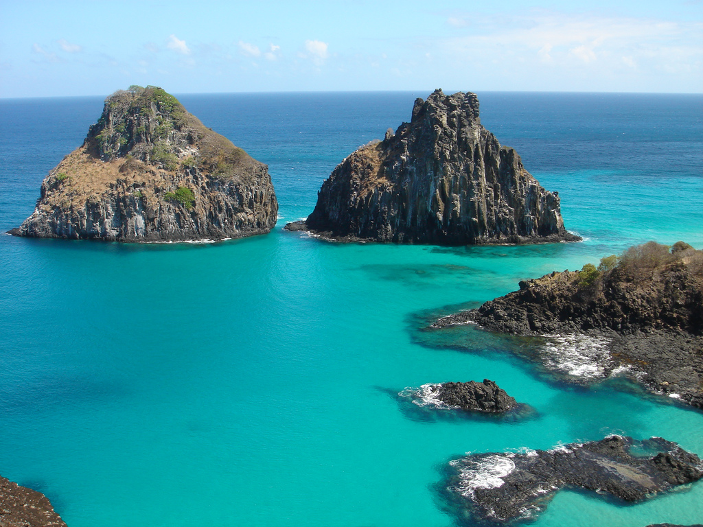
The Gulf of California contains 37 islands – the two largest being Isla Ángel de la Guarda and Tiburón Island. Most of the islands are found on the peninsular side of the gulf. In fact, many of the islands of the Sea of Cortez are the result of volcanic explosions that occurred during the early history of Baja California. The islands of Islas Marías, Islas San Francisco, and Isla Partida are thought to be the result of such explosions. The formations of the islands, however, are not dependent on each other. They were each formed as a result of an individual structural occurrence.[2] Several islands, including Isla Coronado, are home to volcanoes.
Bathymetry
Depth soundings in the gulf have ranged from fording depth at the estuary near Yuma, Arizona to in excess of 3,000 meters (9,800 ft) in the deepest parts. The depth of the water helps to determine its temperature. For example, shallow depths are directly influenced by the local temperature of the air, while deeper waters are less susceptible to changes in air temperature.[2]
Further reading
- Richard C. Brusca, ed. The Gulf of California: Biodiversity and Conservation (University of Arizona Press; 2010) 354 pages; studies by researchers on both sides of the border on the threats to the diversity of species in the gulf's waters.
References
- ^ Ernesto Campos, Alma Rosa de Campos & Jesús Angel de León-González (2009). "Diversity and ecological remarks of ectocommensals and ectoparasites (Annelida, Crustacea, Mollusca) of echinoids (Echinoidea: Mellitidae) in the Sea of Cortez, Mexico". Parasitology Research 105 (2): 479–487. doi:10.1007/s00436-009-1419-8.
- ^ a b c d e f g h Richard C. Brusca (1973). A Handbook to the Common Intertidal Invertebrates of the Gulf of California. Tucson, Arizona: University of Arizona Press. pp. 10–15. ISBN 0816503567.
- ^ "Limits of Oceans and Seas, 3rd edition". International Hydrographic Organization. 1953. http://www.iho-ohi.net/iho_pubs/standard/S-23/S23_1953.pdf. Retrieved February 7, 2010.
- ^ a b c Rebekah K. Nix. "The Gulf of California: A Physical, Geological, and Biological Study" (PDF). University of Texas at Dallas. http://www.utdallas.edu/~rnix/MAT-SE_Units/gulf_cal.pdf. Retrieved April 10, 2010.
- ^ "The Gulf of California Invertebrate Database: The Invertebrate Portion of the Macrofauna Golfo Database". Arizona-Sonora Desert Museum: Center for Sonoran Desert Studies. http://www.desertmuseum.org/center/seaofcortez/database.php.
- ^ "Science Plans RCL". review.nsf-margins.org. http://review.nsf-margins.org/SPRCL.html. Retrieved May 27, 2008.
External links
- All About Baja - Learn all about the Sea of Cortez and the entire Baja peninsula.
- Sea of Cortez Expedition and Education Project
- Desert Museum
- CEDO Intercultural
- PANGAS project
- Kino Bay Center for Cultural and Ecological Studies
World Heritage Sites in Mexico North West Archaeological Zone of Paquimé, Casas Grandes · Islands and Protected Areas of the Gulf of California1 · Rock Paintings of Sierra de San Francisco · Whale Sanctuary of El Vizcaino

North Central Franciscan Missions in the Sierra Gorda of Querétaro · Historic Centre of Zacatecas · Historic Monuments Zone of Querétaro · Historic Town of Guanajuato and Adjacent Mines · Protected town of San Miguel and the Sanctuary of Jesús Nazareno de Atotonilco
West Agave Landscape and Ancient Industrial Facilities of Tequila · Historic Centre of Morelia · Hospicio Cabañas, Guadalajara · Islands and Protected Areas of the Gulf of California1 · Monarch Butterfly Biosphere Reserve1 ·
East Earliest 16th-Century Monasteries on the slopes of Popocatépetl1 · Pre-Hispanic City of El Tajín · Historic Centre of Puebla · Historic Monuments Zone of Tlacotalpan
South West Historic Centre of Oaxaca and Archaeological Site of Monte Albán · Pre-Hispanic City and National Park of Palenque ·
South Central Archaeological Monuments Zone of Xochicalco · Central University City Campus of the UNAM · Earliest 16th-Century Monasteries on the slopes of Popocatépetl1 · Historic Centres of Mexico City and Xochimilco · Luis Barragán House and Studio · Monarch Butterfly Biosphere Reserve1 · Pre-Hispanic City of Teotihuacán
South East Ancient Maya City of Calakmul, Campeche · Historic Fortified Town of Campeche · Pre-Hispanic City of Chichén Itzá · Sian Ka'an · Pre-Hispanic Town of Uxmal
1 Shared with other region/sEarth's oceans and seas Arctic Ocean - Amundsen Gulf
- Barents Sea
- Beaufort Sea
- Bering Strait
- Chukchi Sea
- East Siberian Sea
- Fram Strait
- Greenland Sea
- Gulf of Boothia
- Kara Sea
- Kara Strait
- Laptev Sea
- Lincoln Sea
- Prince Gustav Adolf Sea
- Pechora Sea
- Wandel Sea
- White Sea
Atlantic Ocean - Adriatic Sea
- Aegean Sea
- Alboran Sea
- Archipelago Sea
- Argentine Sea
- Baffin Bay
- Balearic Sea
- Baltic Sea
- Bay of Biscay
- Bay of Bothnia
- Bay of Campeche
- Bay of Fundy
- Black Sea
- Bothnian Sea
- Caribbean Sea
- Celtic Sea
- Davis Strait
- Denmark Strait
- English Channel
- Foxe Basin
- Greenland Sea
- Gulf of Bothnia
- Gulf of Finland
- Gulf of Lion
- Gulf of Guinea
- Gulf of Mexico
- Gulf of St. Lawrence
- Gulf of Venezuela
- Great Lakes
- Hudson Bay
- James Bay
- Ionian Sea
- Irish Sea
- Irminger Sea
- Labrador Sea
- Levantine Sea
- Libyan Sea
- Ligurian Sea
- Marmara Sea
- Mediterranean Sea
- Myrtoan Sea
- North Sea
- Norwegian Sea
- Saint Lawrence Seaway
- Sargasso Sea
- Sea of Åland
- Sea of Azov
- Sea of Crete
- Sea of the Hebrides
- Thracian Sea
- Tyrrhenian Sea
Indian Ocean Pacific Ocean - Arafura Sea
- Bali Sea
- Banda Sea
- Bering Sea
- Bismarck Sea
- Bohai Sea
- Bohol Sea
- Camotes Sea
- Celebes Sea
- Ceram Sea
- Chilean Sea
- Coral Sea
- East China Sea
- Flores Sea
- Gulf of Alaska
- Gulf of California
- Gulf of Carpentaria
- Gulf of Thailand
- Gulf of Tonkin
- Halmahera Sea
- Java Sea
- Koro Sea
- Makassar Strait
- Molucca Sea
- Moro Gulf
- Philippine Sea
- Salish Sea
- Savu Sea
- Sea of Japan
- Sea of Okhotsk
- Seto Inland Sea
- Sibuyan Sea
- Solomon Sea
- South China Sea
- Sulu Sea
- Tasman Sea
- Visayan Sea
- Yellow Sea
Southern Ocean - Amundsen Sea
- Bellingshausen Sea
- Cooperation Sea
- Cosmonauts Sea
- Davis Sea
- D'Urville Sea
- King Haakon VII Sea
- Lazarev Sea
- Riiser-Larsen Sea
- Mawson Sea
- Ross Sea
- Scotia Sea
- Somov Sea
- Weddell Sea
Landlocked seas Categories:- Gulf of California
- Landforms of Mexico
- Colorado River
- Gulfs of the Pacific Ocean
- Regions of Northern Mexico
- World Heritage Sites in Mexico

Wikimedia Foundation. 2010.