- Mulegé
-
Mulegé
Heroica MulegéStreet in town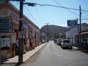 Location in Mexico
 Mulegé
Coordinates: 26°53′30″N 111°58′51″W / 26.89167°N 111.98083°WCoordinates: 26°53′30″N 111°58′51″W / 26.89167°N 111.98083°W Country  Mexico
State Baja California Sur Municipality Mulegé Elevation 52 ft (16 m) Population (2010) - City 3,821 - Urban 3,821 Time zone Pacific (US Mountain) (UTC-7) - Summer (DST) Pacific (UTC-6) Mulegé is an oasis town in the Mexican state of Baja California Sur, situated at the mouth of the Río de Santa Rosalía. It is the fourth-largest community in Mulegé Municipality. It had a population of 3,821 according to the Mexican federal census of 2010.
Contents
History
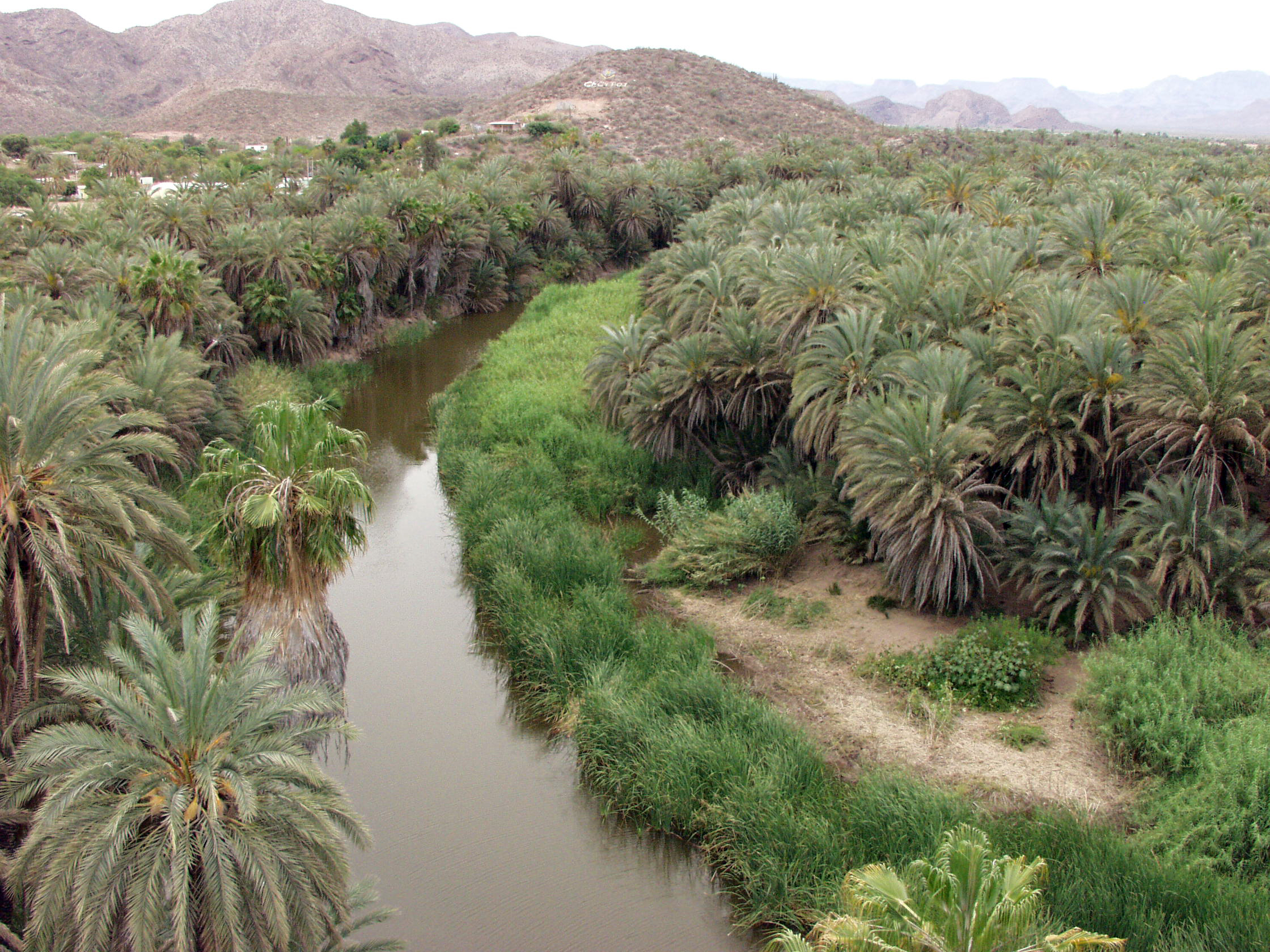
 Photo taken from the Mulegé Mission
The river valley of today's Mulegé was discovered in 1702 by the Jesuit Father Juan Maria de Salvatierra as a place for a mission and consequently for a settlement. Like everywhere in Central and South America, it was the Spanish Conquistadores and behind them, the Spanish Church, who established missions and settlements, with the intention of conquering the entire area for the Church and the Crown. The valley of the then-unnamed river was ideal for a mission and a settlement, because of its abundance of water.
In 1754 Father Francisco Escalante started the construction of the mission. Years later many other Jesuit fathers came into today's area of Mulegé to bring the Catholic faith and convert the natives to Catholicism.
Heroica Mulegé
The official name of the town is "Heroica Mulegé." This title is based on incidents during the American-Mexican war 1846-1848. The 'Americanos' tried to occupy long stretches of the Pacific coast like California, Baja California and New Mexico which belonged to Mexico at that time. The effort was made as a blockade and to battle Mexican General Santa Ana who was fighting a war in Texas (the Battle of the Alamo, Battle of San Antonio, Battle of San Jacinto, and so on.) The people of Mulegé and surrounding settlements along the Pacific coastline defeated the 'Gringos.' As a result Mulegé was not occupied and was rewarded the official title "Heroica Mulegé." Even today, on any official letters of the Government of Baja California Sur you will find the title "Heroica Mulegé."
Tourist Spots / Attractions
- The Mission, founded in 1705, is one of the most famous attractions in Mulegé. It is located high above the river, overlooking the entire river valley.
- The caves in the 'Sierra de Guadalupe' near Mulegé with extensive cave paintings are worth a visit, as are the caves in the 'Sierra de San Borjita' and La Trinidad.
- A special feature of the town is the old prison. It was erected completely without bars. The prisoners could freely walk around town and even go as far as to establish and maintain families. They just had to return to the prison in the evening. Escapes were rare because of the remoteness of Mulegé and until Mex 1 was paved there was nothing but empty desert to which to flee. Also, all prisoners had to agree to assist in tracking any escapist and assist in their capture. Today, the old prison is a museum suggesting a nominal (M$15) fee for entry.
Economy
All over the world Mulegé is famous for its rich fishing grounds in the Sea of Cortez. A warm current from the southern and a cold current from the northern Pacific come together in the Mulegé area of the Sea of Cortez and creates a great variety of different fish species. The Sea of Cortez is named after the Spanish explorer Hernán Cortés. In the past Mulegé made its living mostly from fishing and from farming produce. Today tourism is a major income source for Mulegé. Deep sea fishing is one of Mulegé's tourist attractions. Kayaking, cave tours and bird watching, fishing with or without charters to catch a big game fish are popular attractions. Today's tourism industry in Mulegé is based on the fact that in 1976 the Highway MX1 - a paved road - was constructed and Mulegé was easily accessible by land. A trip from the US border to Mulegé which takes no more than 12 hours today, could last four or more days before the construction of today's highway. A major setback to the tourist industry in Mulege was hurricane 'John' in 2006. Hurricane "Julio" in 2008 and hurricane "Jimena" in 2009 All three hurricanes created major precipitation followed by high floods. All over the Mulege area from the Pacific to the Sea of Cortez rainfall and floods where devastating. Mulege was flooded by over 20 feet of waters at the highway bridge and still by 6 feet in upper regions of town. Many homes located in the river valley where washed into the Sea of Cortez. Clean-Up is still not completed at this time, end of 2011.
Climate and Agriculture
The entire peninsula of Baja California is an area with one of the lowest precipitation rates in the world. Rain is rare but usually occurs between December and March, and hurricanes are occasionally a major threat to the Mulegé area. There is a saying in Baja California: "It never rains in Baja, but if it rains, it pours." Due to fertile soil and a rich water supply in the Mulegé river valley, irrigation is possible like nowhere else in Baja California, making agriculture a booming industry. Farming is focused on all sorts of produce. Oranges, bananas, limes and mangoes, to name a few, are found in Mulegé and the surrounding area.
Transportation
By land, Mulegé is accessible by Federal Highway 1, which runs from Tijuana at the US-MX border to Cabo San Lucas. The highway was built in 1975/76. Before that, Mulegé was only accessible via dirt road leading from Tijuana at the U.S. border to Cabo San Lucas at the southern-most point of Baja California Sur. The trip took about four days by car or truck. Considering that the 'old road' was just a dirt road leading through big lava fields with lava rocks, blown tires were very common those days and a breakdown was always blocking the road in one direction. Mulegé was also accessible by private aircraft, and of course by sea. Mulegé, as well as other towns of the entire peninsula, has been a destination for private air travel since the mid 1950s. Celebrities like John Wayne, to name just one, have visited Mulegé, mostly because Mexico had no regulation on alcohol. Even today the non-existence of any 'Open Can Law' attracts many Americans. The northern part of the Baja peninsula consists mostly of lava rocks and many streets even today are covered with those rocks. In the southern part - South of 'CD Constitucion' - the land consists more of sand and gravel. NOTE: The northern part of the peninsular is named officially 'Baja California' while the southern part is named 'Baja California Sur'. Both parts are separate Mexican states. Mulegé is served by three airstrips in the area which have no importance for public travel but are more for private air travel: a graded dirt & hoof strip that is somehow maintained at the Serenidad Hotel. Extra caution is advised when using this airstrip as dogs and other animals as well as Mexican citizens are frequently crossing the strip. Also at high tide, the strip can be very muddy or even submerged. The strip is located only a very short distance from the Sea of Cortez, more or less at sea level Mulegé Municipal, and the farthest Punta San Pedro (at Concepcion Bay). Regional flights are available at the Palo Verde Airport (to the north of town), and international flights are available at the Loreto Airport (123 km to the south).
The Municipality
Mulegé Municipality reaches from Guerrero Negro about 250 KM (156 mls) north of Mulegé to about 60 KM (40mls) south of Mulegé. But Mulegé is not the municipal seat. That is Santa Rosalia.
The mission in Mulegé is named 'Misión de Santa Rosalía'. The mission in Santa Rosalia is named 'Santa Bárbara'.
The river is officially named 'Río de Santa Rosalía, but usually called 'Río Mulegé' There is no river in Santa Rosalia
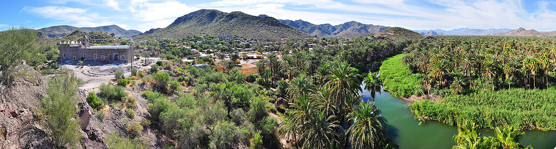 180° Panorama of the Misión Santa Rosalía de Mulegé backed by mountains: La Misión and Santa Clara. The meandering Mulegé River appears on the right lined with palm trees as seen on a sunny December afternoon.
References
- 2010 census tables: INEGI: Instituto Nacional de Estadística, Geografia e Informática
External links
- Global Positioning System 26°53′30″N 111°58′51″W / 26.89167°N 111.98083°W
- Baja Travel Guide Online trip planner for your next vacation in Mulegé.
- www.AllAboutBaja.com Learn all about Mulegé and the magnificent Baja peninsula.
Categories:- Populated places in Baja California Sur


Wikimedia Foundation. 2010.