- Mexican Federal Highway 1
-
Federal Highway 1
Carretera Federal 1 Carretera Transpeninsular Route information Length: 1,711 km (1,063 mi) Major junctions South end: Cabo San Lucas North end:  I-5 at U.S.–Mexico border near Tijuana
Highway system ←  Fed. 307
Fed. 1D  →
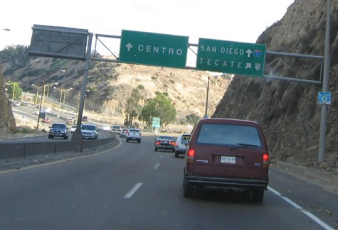
→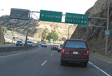 A sign of the highway displaying how to get to San Diego.
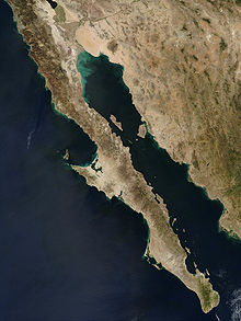 The road runs the entire length of the Baja California Peninsula
Mexican Federal Highway (carretera federal) No. 1 follows the length of the Baja California Peninsula from Cabo San Lucas (BCS), at the southern end to Tijuana (BC) in the north. The road turns into Interstate 5 at the international border with the United States south of San Ysidro, California.
Highway 1 is often called the Carretera Transpeninsular or Transpeninsular Highway and runs a length of 1,711 km (1,063 mi) from Tijuana to Cabo San Lucas. Most of its length is two lanes. Construction was completed in 1973.
Route description
The road begins in the border city of Tijuana. It is bypassed from here to Ensenada by Mexican Federal Highway 1D, a toll road. Then, the road continues south past Maneadero. Much of it follows or passes near the route of Portola's march from Loreto to San Diego during the foundation of Spanish missions in Baja California.
Federal highways in Mexico are generally designated with even numbers for east–west routes and odd numbers for north–south routes. Numerical designations usually ascend southward away from the U.S. border for east–west routes, and usually ascend eastward away from the Pacific Ocean for North-South routes. Therefore, Federal Highway 1, due to its proximity to the Pacific Ocean, has the lowest possible odd number designation, and intersecting East-West federal routes usually conform to this pattern.
Kilometer markers track the distance along Mex 1 through Baja California Norte in four segments. The first of these is the 109 km length from Tijuana to Ensenada, which is known informally as Mex 1 Libre to distinguish it from the parallel toll road. The second portion of signed road runs 196 km from Ensenada to San Quintín. The third segment comprises 128 km from San Quintín to Bahía de los Ángeles. A final segment stretches 128 km from Bahía de los Ángeles to the border of Baja California Sur. The total length of Mexican Federal Highway 1 in Baja California Norte is 713 km (443 mi).
Continuing into the southern of the two Mexican states that comprise the Baja California peninsula, Guerrero Negro is the nearest community to the point where Mex 1 meets the 28th parallel north. Afterward Mex 1 leaves the western coast and crosses to the eastern coast at Santa Rosalía. The route continues southward past Puerto Escondido and gains altitude at Sierra de la Giganta, then veers southwest and through agricultural lands and Ciudad Constitución. After crossing a desert the route encounters La Paz on the eastern coast. The route continues along the gulf side of the peninsula through San José del Cabo to its terminus at Cabo San Lucas.
After crossing state lines the kilometer markers progress in the opposite direction. Baja California Norte markers count from north to south, but Baja California Sur markers count from south to north. So in opposite order from the road signage, a progressive route southward would span 221 km from Guerrero Negro to Santa Rosalía, 197 km from Santa Rosalía to Loreto, 120 km from Loreto to Ciudad Insurgentes, 240 km from Ciudad Insurgentes to La Paz, and 224 km from La Paz to Cabo San Lucas.
Baja California
- 32°32′34.09″N 117°01′47.57″W / 32.5428028°N 117.0298806°W United States–Mexico border (Tijuana)
- 32°22′18.57″N 117°03′36.24″W / 32.371825°N 117.0600667°W Playas de Rosarito
- 31°52′12.01″N 116°37′12.00″W / 31.8700028°N 116.62°W Ensenada
- 30°31′26.78″N 115°55′51.78″W / 30.5241056°N 115.93105°W San Quintín
- 30°03′13.01″N 115°44′08.72″W / 30.0536139°N 115.7357556°W El Rosario
- 29°43′42.71″N 114°43′06.83″W / 29.7285306°N 114.7185639°W Cataviña
- 29°02′43.12″N 114°09′10.24″W / 29.0453111°N 114.1528444°W Highway 12 to Bahía de los Ángeles
- 28°55′43.08″N 114°09′24.96″W / 28.9286333°N 114.1569333°W Punta Prieta
- 28°38′19.04″N 114°01′16.34″W / 28.6386222°N 114.0212056°W El Rosarito
- 28°16′51.93″N 113°59′58.58″W / 28.2810917°N 113.9996056°W Villa Jesús María and road to Sebastián Vizcaíno Bay
- 28°00′00.00″N 114°00′43.88″W / 28°N 114.0121889°W State Line (28th parallel north)
Baja California Sur
- 27°58′02.14″N 114°00′51.85″W / 27.9672611°N 114.0144028°W Guerrero Negro
- 27°18′05.50″N 112°52′44.30″W / 27.301528°N 112.878972°W San Ignacio, road to San Ignacio Lagoon
- 27°20′04.64″N 112°15′55.38″W / 27.3346222°N 112.2653833°W Santa Rosalía
- 26°53′33.27″N 111°58′38.71″W / 26.892575°N 111.9774194°W Mulegé
- 26°00′27.09″N 111°21′02.07″W / 26.007525°N 111.350575°W Loreto
- 25°15′13.98″N 111°46′31.60″W / 25.2538833°N 111.775444°W Ciudad Insurgentes
- 25°01′30.66″N 111°40′11.23″W / 25.0251833°N 111.6697861°W Ciudad Constitución
- 24°08′26.60″N 110°18′42.46″W / 24.140722°N 110.3117944°W La Paz
- 23°55′28.89″N 110°15′53.21″W / 23.9246917°N 110.2647806°W San Pedro
- 23°53′57.76″N 110°15′29.31″W / 23.8993778°N 110.2581417°W Highway 19 to Todos Santos & El Pescadero; shortcut to Cabo San Lucas
- 23°48′33.82″N 110°03′26.66″W / 23.8093944°N 110.0574056°W San Antonio
- 23°32′30.37″N 109°40′40.49″W / 23.5417694°N 109.6779139°W Santiago
- 23°09′21.30″N 109°42′29.64″W / 23.155917°N 109.7082333°W Los Cabos International Airport (at airport exit)
- 23°02′40.35″N 109°42′21.06″W / 23.0445417°N 109.70585°W San José del Cabo - as Boulevard Mauricio Castro
- 22°57′54.44″N 109°47′55.31″W / 22.9651222°N 109.7986972°W Los Cabos Corridor (at transpeninsular monument)
- 22°52′58.15″N 109°54′52.77″W / 22.8828194°N 109.9146583°W Cabo San Lucas - as Boulevard Lázaro Cárdenas
 Mexican Federal Highways
Highways 1 • 2 • 3 • 5 • 8 • 9 • 10 • 11 • 12 • 14 • 15 • 16 • 17 • 18 • 19 • 20 • 22 • 23 • 24 • 25 • 26 • 28 • 29 • 30 • 31 • 34 • 35 • 36 • 37 • 38 • 40 • 41 • 43 • 44 • 45 • 47 • 49 • 51 • 52 • 53 • 54 • 55 • 57 • 58 • 61 • 62 • 63 • 64 • 66 • 68 • 69 • 70 • 71 • 72 • 74 • 76 • 78 • 80 • 81 • 82 • 84 • 85 • 87 • 90 • 93 • 95 • 97 • 98 • 100 • 101 • 102 • 103 • 105 • 106 • 107 • 110 • 111 • 113 • 114 • 115 • 116 • 117 • 119 • 120 • 121 • 123 • 125 • 126 • 127 • 128 • 129 • 130 • 131 • 132 • 134 • 135 • 136 • 138 • 140 • 142 • 143 • 144 • 145 • 147 • 150 • 160 • 162 • 166 • 172 • 175 • 176 • 178 • 179 • 180 • 182 • 184 • 185 • 186 • 187 • 188 • 190 • 193 • 195 • 196 • 198 • 199 • 200 • 202 • 203 • 211 • 217 • 220 • 221 • 225 • 247 • 254 • 259 • 261 • 263 • 265 • 281 • 293 • 295 • 307Categories:- Mexican Federal Highways


Wikimedia Foundation. 2010.