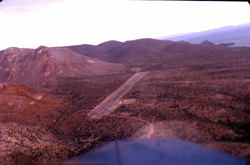
Mulegé Airstrip

Mulegé Airstrip
Mulegé Airstrip
IATA: MUGICAO: MMMG
Summary
Airport type Public
Location Mulegé
Elevation AMSL 124 ft / 38 m
Coordinates 26°54′21″N 111°58′14″W / 26.90583°N 111.97056°W / 26.90583; -111.97056Coordinates: 26°54′21″N 111°58′14″W / 26.90583°N 111.97056°W / 26.90583; -111.97056
Runways
Direction Length Surface
ft m
17/35 2,318 706 Soil


Mulegé Airstrip or Mulegé Municipal Airstrip (IATA: MUGICAO: MMMG) is a public dirt airstrip located 3 km North East of Mulegé, Municipality of Mulegé, Baja California Sur, Mexico, on the North bank of the Mulegé River, 3 km from the Gulf of California coast. The airstrip is used solely for general aviation purposes, secondary to the El Gallito Airstrip, which is the most used, due to better quality of installations and the safety conditions. [1]

External links


Wikimedia Foundation. 2010.

Игры ⚽ Поможем написать реферат

Look at other dictionaries:

  • Mulegé — Heroica Mulegé Street in town …   Wikipedia

  • El Gallito Airstrip — Infobox Airport name = El Gallito Airstrip nativename = nativename a = nativename r = image width = caption = IATA = ICAO = type = Private owner = operator = Hotel Serenidad city served = location = Mulegé elevation f = 33 elevation m = 10… …   Wikipedia

  • Rancho Chávez Airstrip — Infobox Airport name = Rancho Chávez Airstrip nativename = nativename a = nativename r = image width = caption = IATA = ICAO = type = Private owner = operator = city served = location = Mulegé elevation f = 68 elevation m = 20 coordinates =… …   Wikipedia

  • Punta San Pedro Airstrip — Infobox Airport name = Punta San Pedro Airstrip nativename = nativename a = nativename r = image width = caption = IATA = ICAO = type = Public owner = operator = city served = location = Mulegé elevation f = 75 elevation m = 23 coordinates =… …   Wikipedia

  • Santa María de Mulegé Airport — Infobox Airport name = Santa María de Mulegé Airport nativename = nativename a = nativename r = image width = caption = IATA = ICAO = type = Public owner = operator = Municipality of Mulegé Government city served = location = Santa Rosalía, Baja… …   Wikipedia

  • Isla San Marcos Airstrip — Infobox Airport name = Isla San Marcos Airstrip nativename = nativename a = nativename r = image width = caption = IATA = ICAO = type = Private owner = operator = Compañía Occidental Mexicana SA de CV city served = location = San Marcos, Baja… …   Wikipedia

  • Isla Natividad Airstrip — Infobox Airport name = Isla Natividad Airstrip nativename = nativename a = nativename r = image width = caption = IATA = ICAO = type = Private owner = operator = SCPP Buzos y Pescadores de la Baja California , SCL city served = location =… …   Wikipedia

  • Bahía Ballenas Airstrip — Infobox Airport name = Bahía Ballenas Airstrip nativename = nativename a = nativename r = image width = caption = IATA = ICAO = type = owner = operator = city served = location = elevation f = elevation m = coordinates =… …   Wikipedia

  • San Lucas Military Airstrip — Infobox Airport name = San Lucas Military Airstrip nativename = nativename a = nativename r = image width = caption = IATA = ICAO = type = Military owner = operator = Secretaría de la Defensa Nacional city served = location = Santa Rosalía, Baja… …   Wikipedia

  • Bahía Asunción Airstrip — Infobox Airport name = Bahía Asunción Airstrip nativename = nativename a = nativename r = image width = caption = IATA = ICAO = type = Public owner = operator = N/A city served = location = Bahía Asunción elevation f = 130 elevation m = 39… …   Wikipedia

Share the article and excerpts

Direct link
Do a right-click on the link above
and select “Copy Link”