- Yuma, Arizona
Infobox Settlement
official_name = City of Yuma, Arizona
other_name =
native_name =
nickname =
motto =
imagesize = 250px
image_caption = Old Yuma Post Office
flag_size =
image_
seal_size =
image_shield =
shield_size =
image_blank_emblem =
blank_emblem_size =
flag_size =
image_
seal_size =
image_shield =
shield_size =
image_blank_emblem =
blank_emblem_size =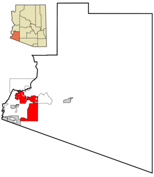
mapsize = 250px
map_caption = Location of Yuma, Arizona
mapsize1 =
map_caption1 =
pushpin_
pushpin_label_position =
subdivision_type = Country
subdivision_name =United States
subdivision_type1 = State
subdivision_name1 =Arizona
subdivision_type2 = County
subdivision_name2 = Yuma
government_type =
leader_title =Mayor
leader_name =Lawrence K. Nelson (R)
leader_title1 =
leader_name1 =
leader_title2 =
leader_name2 =
leader_title3 =
leader_name3 =
leader_title4 =
leader_name4 =
established_title =
established_date =
established_title2 = Incorporated
established_date2 = 1914
established_title3 =
established_date3 =
area_magnitude =
unit_pref =
area_footnotes =
area_total_km2 = 276.4
area_land_km2 = 276.2
area_water_km2 = 0.2
area_total_sq_mi = 106.7
area_land_sq_mi = 106.7
area_water_sq_mi = 0.1
area_water_percent = 0.07
area_urban_km2 =
area_urban_sq_mi =
area_metro_km2 =
area_metro_sq_mi =
population_as_of = 2007
population_footnotes =cite web|url=http://www.census.gov/popest/cities/tables/SUB-EST2007-04-04.csv|title=Annual Estimates of the Population for Incorporated Places in Arizona|publisher=United States Census Bureau |date=2008-07-10|accessdate=2008-07-14]
population_note =
settlement_type =City
population_total = 88687
population_density_km2 = 280.6
population_density_sq_mi = 726.8
population_metro =
population_density_metro_km2 =
population_density_metro_sq_mi =
population_urban =
population_density_urban_km2 =
population_density_urban_sq_mi =
timezone = MST (no DST)
utc_offset = -7
timezone_DST =
utc_offset_DST =
area_code = 928 928
GNIS_id = 14111
latd = 32 |latm = 41 |lats = 32 |latNS = N
longd = 114 |longm = 36 |longs = 55 |longEW = W
elevation_footnotes =
elevation_m = 43
elevation_ft = 138
postal_code_type =
postal_code =
area_code = 928
GNIS_id = 14111
website = http://www.YumaAZ.gov/
blank_name = FIPS code
blank_info = 04-85540
blank1_name =
blank1_info =
footnotes =Yuma is a city in and the
county seat GR|6 of Yuma County,Arizona ,United States . The population of the city was 77,515 at the 2000 census, with a 2006 Census Bureau estimated population of 87,423.cite web | date =June 21 2006 | url = http://www.census.gov/popest/cities/tables/SUB-EST2005-04-04.csv | title = Annual Estimates of the Population for All Incorporated Places in Arizona|format = CSV | work = 2005 Population Estimates | publisher = U.S. Census Bureau, Population Division | accessmonthday = November 14 | accessyear = 2006]Geography
Yuma is located at coor dms|32|41|32|N|114|36|55|W|city (32.692148, -114.615389)GR|1, close to the border, with
California to the west and withMexico to the south. Yuma is just west of the Gila and Colorado River confluence.According to the
United States Census Bureau , the city has a total area of 106.7 square miles (276.4 km²), of which, 106.7 square miles (276.2 km²) of it is land and 0.1 square miles (0.2 km²) of it (0.07%) is water.History
The area's first settlers were Native American Tribes, whose descendants occupy the
Cocopah andQuechan reservations near the city. In 1540, expeditions underHernando de Alarcon andMelchior Diaz visited here and immediately saw the natural crossing of the Colorado River was an ideal spot for a city.was born and spent much of his life in Yuma.
Demographics
USCensusPop
1870=1144
1880=1200
1890=1773
1900=1519
1910=2914
1920=4237
1930=4892
1940=5325
1950=9145
1960=23974
1970=29007
1980=42481
1990=56966
2000=77515
estimate=88687
estyear=2007
footnote= [Gibson, Campbell. " [http://www.census.gov/population/www/documentation/twps0027.html Population of the 100 Largest Cities and Other Urban Places in the United States: 1790 to 1990] ." "United States Census Bureau ." June, 1998. Retrieved onOctober 7 2006 .] Yuma is the central city of the Yuma, AZ MSA (Metropolitan Statistical Area ), which consists of Yuma County. According to theUnited States Census Bureau , the 2007 estimated population of the Yuma MSA is 190,557, [ [http://www.census.gov/population/www/estimates/metrodef.html Current Lists of Metropolitan and Micropolitan Statistical Areas and Definitions ] ] though more than 85,000 winter visitors make Yuma their winter residence. [ cite web|url=http://www.greateryuma.org/cityofyuma.html?GCCID=e6a74205f313379e0e0fee06668ddc4a |title=City of Yuma |accessdate=2007-06-23 |publisher=Greater Yuma Economic Development Corporation ]As of the
census GR|2 of 2000, there were 77,515 people, 26,649 households, and 19,613 families residing in the city. Thepopulation density was 726.8 people per square mile (280.6/km²). There were 34,475 housing units at an average density of 323.3/sq mi (124.8/km²). The racial makeup of the city was 68.33% White, 3.21% Black or African American, 1.51% Native American, 1.50% Asian, 0.19% Pacific Islander, 21.36% from other races, and 3.90% from two or more races. 45.67% of the population were Hispanic or Latino of any race.There were 26,649 households out of which 38.8% had children under the age of 18 living with them, 56.6% were married couples living together, 13.1% had a female householder with no husband present, and 26.4% were non-families. 21.7% of all households were made up of individuals and 9.8% had someone living alone who was 65 years of age or older. The average household size was 2.79 and the average family size was 3.27.
In the city the population was spread out with 29.6% under the age of 18, 11.9% from 18 to 24, 27.1% from 25 to 44, 17.5% from 45 to 64, and 13.9% who were 65 years of age or older. The median age was 31 years. For every 100 females there were 99.1 males. For every 100 females age 18 and over, there were 97.2 males.
According to the 2006 American Community Survey estimate, the median income for a household in the city was $39,885, and the median income for a family was $41,588. Males had a median income of $35,440 versus $27,035 for females. The
per capita income for the city was $18,393. About 14.1% of families and 16.9% of the population were below thepoverty line , including 23.4% of those under age 18 and 13.9% of those age 65 or over. The high poverty rate may be due to unemployment, as Yuma tops CareerBuilder.com's list of 20 U.S. cities with the highest unemployment rates. [ [http://msn.careerbuilder.com/custom/msn/careeradvice/viewarticle.aspx?articleid=834&SiteId=cbmsnhp4834&sc_extcmp=JS_834_home1&cbRecursionCnt=2&cbsid=9993d2fb3f4747d195c6366fd1466500-212781996-WB-2>1=8522|¹ CareerBuilder.com Article] ]Climate
Yuma is one of the hottest cities of any size in the United States, with average July high temperatures of 107 degrees
Fahrenheit . (By way of comparison, the corresponding figure forDeath Valley is 115 degrees.) Average January highs are around 69 degrees. According to theGuinness Book of World Records , Yuma is the sunniest place on earth. Of the possible 4,456 hours of daylight each year, the sun shines in Yuma for roughly 4,050 hours, or about 90% of the time. The near perfect flying weather year round attracts military interest in training their pilots here. On average Yuma receives about 3 inches of rain annually.On
July 28 1995 Yuma reached its all-time high at 124 degrees. The lowest temperature for Yuma to fall to was 13 degrees on the Yuma mesa in January 2007. The temperature fell to 13 degrees for approximately 2 hours and was detrimental to the many crops grown in and around Yuma. The crop that suffered the most damage was the citrus on the Yuma mesa, most notably the Lemon crop which suffered a 75 to 95% loss of not only crop, but trees and stated by the Arizona Department of Agriculture in a February 2007 report.In 1997, the desert city sustained a full
tropical storm after Hurricane Nora madelandfall at the mouth of the Colorado River and quickly moved due north along it. The extraordinarily rare event cut power to 12,000 customers in Yuma, and dropped 3.59inch es or over 90mm ofrain atMarine Corps Air Station Yuma .Infobox Weather
metric_first= Yes
single_line= Yes
location = Yuma
Jan_Hi_°C = 21 |Jan_REC_Hi_°C = 31
Feb_Hi_°C = 24 |Feb_REC_Hi_°C = 36
Mar_Hi_°C = 27 |Mar_REC_Hi_°C = 38
Apr_Hi_°C = 31 |Apr_REC_Hi_°C = 42
May_Hi_°C = 35 |May_REC_Hi_°C = 47
Jun_Hi_°C = 40 |Jun_REC_Hi_°C = 50
Jul_Hi_°C = 42 |Jul_REC_Hi_°C = 51
Aug_Hi_°C = 41 |Aug_REC_Hi_°C = 49
Sep_Hi_°C = 38 |Sep_REC_Hi_°C = 47
Oct_Hi_°C = 32 |Oct_REC_Hi_°C = 44
Nov_Hi_°C = 25 |Nov_REC_Hi_°C = 37
Dec_Hi_°C = 21 |Dec_REC_Hi_°C = 30
Year_Hi_°C = 31 |Year_REC_Hi_°C = 51
Jan_Lo_°C = 8 |Jan_REC_Lo_°C = -11
Feb_Lo_°C = 9 |Feb_REC_Lo_°C = -2
Mar_Lo_°C = 12 |Mar_REC_Lo_°C = 0
Apr_Lo_°C = 14 |Apr_REC_Lo_°C = 5
May_Lo_°C = 18 |May_REC_Lo_°C = 8
Jun_Lo_°C = 23 |Jun_REC_Lo_°C = 12
Jul_Lo_°C = 27 |Jul_REC_Lo_°C = 17
Aug_Lo_°C = 27 |Aug_REC_Lo_°C = 17
Sep_Lo_°C = 24 |Sep_REC_Lo_°C = 12
Oct_Lo_°C = 18 |Oct_REC_Lo_°C = 2
Nov_Lo_°C = 11 |Nov_REC_Lo_°C = -1
Dec_Lo_°C = 8 |Dec_REC_Lo_°C = -3
Year_Lo_°C = 17 |Year_REC_Lo_°C = -11
Jan_Precip_cm = |Jan_Precip_mm = 10
Feb_Precip_cm = |Feb_Precip_mm = 7
Mar_Precip_cm = |Mar_Precip_mm = 7
Apr_Precip_cm = |Apr_Precip_mm = 2
May_Precip_cm = |May_Precip_mm = 1
Jun_Precip_cm = |Jun_Precip_mm = 1
Jul_Precip_cm = |Jul_Precip_mm = 6
Aug_Precip_cm = |Aug_Precip_mm = 16
Sep_Precip_cm = |Sep_Precip_mm = 7
Oct_Precip_cm = |Oct_Precip_mm = 7
Nov_Precip_cm = |Nov_Precip_mm = 4
Dec_Precip_cm = |Dec_Precip_mm = 7
Year_Precip_cm = |Year_Precip_mm = 75
source =ites of interest
Yuma contains the historical
Yuma Territorial Prison , the Yuma Quartermasters Depot State Historic Park (formerly known as the Yuma Crossing Historic Park), and a historic downtown area. Yuma is an "Arizona Main Street City".Near Yuma are the Kofa Mountain Range and wildlife refuge, Martinez and Mittry Lakes, and the
Algodones Dunes .The city is also the location of the
Marine Corps Air Station Yuma , which conducts an annual air show and many large-scale military exercises. There is also theYuma Proving Ground , an Army base which tests new military equipment.Another point of interest in Yuma is the
Colorado River which runs along the north and west side of town dividing Arizona and California. Yuma is an important station for trucking industry movement of goods between California, Arizona, and Mexico.ports
Yuma has a minor league ballpark,
Desert Sun Stadium home to theYuma Scorpions of theGolden Baseball League and site of home games of two (was four) teams for theArizona Winter League . [ [http://www.goldenbaseball.com/Yuma] ] TheSan Diego Padres used the field as a spring training facility from 1969 until 2000. [ [http://mlb.mlb.com/news/article.jsp?ymd=20070324&content_id=1858369&vkey=spt2007news&fext=.jsp&c_id=sd] ] and aJapanese baseball team, theYakult Swallows used the field for spring training for 20 years. [ [http://www.caballeros.org/spring.htm] ]Famous residents
*
Cesar Chavez
*J. Oliver Johnson - writer
*Bengie Molina [ [http://senorboriqua.net/baseball/Molina.html] Molina attended Arizona Western Community College in Yuma, AZ and graduated with AA degree in 1992]
*Tyler Bingham - Enrollment CounselorTransportation
*
Yuma International Airport
*Yuma (Amtrak station)
*Greyhound Lines ee also
*
Winterhaven, California
*Imperial Sand Dunes References
External links
* [http://www.ci.yuma.az.us City of Yuma Website]
* [http://www.visityuma.com Yuma Convention and Visitors Bureau Website]
* [http://www.yuma.usmc.mil MCAS Yuma Official Website]
* [http://www.city-data.com/city/Yuma-Arizona.html Yuma Stats]
* [http://www.yuma.nau.edu Northern Arizona University, Yuma Campus]
Wikimedia Foundation. 2010.