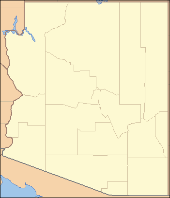
- List of counties in Arizona
-
There are 15 counties in the U.S. state of Arizona. There is also one defunct county: Pah-Ute County was formed in 1865 from Mohave County and returned in 1871. Four counties (Mohave, Pima, Yavapai and Yuma) were created in 1864 following the organization of the Arizona Territory in 1862. All but La Paz County were created by the time Arizona was granted statehood in 1912.[1]
The names of many of the counties pay tribute to the state's Native American heritage. Fully nine of the fifteen counties are named after various native groups that are resident in parts of what is now Arizona. Three of the other counties have Spanish names from the language of the early Hispanic explorers of Arizona: La Paz County, Santa Cruz County, and Pinal County. Another county, Graham County, is named for a physical feature, Mount Graham, with the final county, Greenlee County, being named after one of the state's early pioneers.[2]
Arizona's postal abbreviation is AZ and its FIPS code is 04.
Alphabetical listing
County FIPS code
[3]County seat
[4]Established
[4]Formed from
[1]Etymology
[2]Population
[4][5]Area
[4][5]Map Apache County 001 St. Johns 1879 Part of Yavapai County. The Apache Native American people, who are resident in northeastern Arizona. 69,980 11,218 sq mi
(29,054 km2)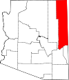
Cochise County 003 Bisbee 1881 Part of Pima County. Cochise, the Apache Native American leader. 127,866 6,219 sq mi
(16,107 km2)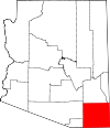
Coconino County 005 Flagstaff 1891 Part of Yavapai County. Coconino Native American people, a Hopi designation for Havasupai and Yavapai people. 127,450 18,661 sq mi
(48,332 km2)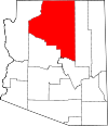
Gila County 007 Globe 1881 Parts of Maricopa County and Pinal County. Gila River, a river that flows through Arizona, whose name comes from a Pima Indian word. 51,994 4,796 sq mi
(12,422 km2)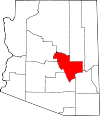
Graham County 009 Safford 1881 Parts of Apache County and Pima County. Mount Graham, a mountain located in Arizona's Pinaleno Mountains. 34,769 4,641 sq mi
(12,020 km2)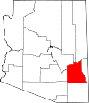
Greenlee County 011 Clifton 1909 Part of Graham County. Mason Greenlee, a pioneer prospector in the area who died in 1903.[6] 7,754 1,848 sq mi
(4,786 km2)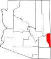
La Paz County 012 Parker 1983 Part of Yuma County. La Paz, Arizona, a historic boomtown on the Colorado River. La paz means the peace in Spanish. 20,172 4,513 sq mi
(11,689 km2)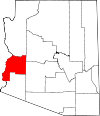
Maricopa County 013 Phoenix 1871 Parts of Pima County and Yavapai County. Maricopa Native American people. 3,990,181 9,224 sq mi
(23,890 km2)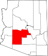
Mohave County 015 Kingman 1864 One of the original 4 counties. Mohave Indians, one of the Yuma tribes. 194,944 13,470 sq mi
(34,887 km2)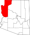
Navajo County 017 Holbrook 1895 Part of Apache County. Navajo Native American people. 111,273 9,959 sq mi
(25,794 km2)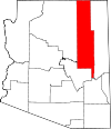
Pima County 019 Tucson 1864 One of the original 4 counties. Pima Native American people, called in their own language Akimel O'odham (river people). 1,003,235 9,189 sq mi
(23,799 km2)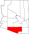
Pinal County 021 Florence 1875 Parts of Maricopa and Pima counties. Pinal Mountains (named from the Spanish for stand of pines) and the Pinal Indian people (a band of Coyotero Apaches) who lived there. 324,962 5,374 sq mi
(13,919 km2)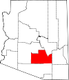
Santa Cruz County 023 Nogales 1899 Parts of Cochise and Pima counties. Santa Cruz River, a small river that flows through Arizona. 42,845 1,238 sq mi
(3,206 km2)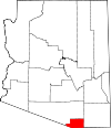
Yavapai County 025 Prescott 1864 One of the original 4 counties. Yavapai Native American people, who are from central Arizona 212,635 8,128 sq mi
(21,051 km2)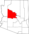
Yuma County 027 Yuma 1864 One of the original 4 counties. Yuma Indians, today called the Quechan. 190,557 5,519 sq mi
(14,294 km2)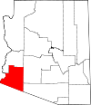
References
- ^ a b Adams, Ward R. (1997). History of Arizona. Higginson Book Company. ISBN 0832870447.
- ^ a b Kane, Joseph and Aiken, Charles (2004). The American Counties: Origins of County Names, Dates of Creation, and Population Data, 1950-2000. Scarecrow Press. ISBN 0810850362. http://books.google.com/books?id=yC9vFvCuW84C&pg=PA333&dq=arizona+county+origins.
- ^ "EPA County FIPS Code Listing". EPA. http://www.epa.gov/enviro/html/codes/az.html. Retrieved 2007-04-09.
- ^ a b c d National Association of Counties. "NACo - Find a county". http://www.naco.org/Template.cfm?Section=Find_a_County&Template=/cffiles/counties/state.cfm&state.cfm&statecode=AZ. Retrieved 2008-04-30.
- ^ a b "Arizona QuickFacts". U.S. Census Bureau. http://www.census.gov/popest/counties/tables/CO-EST2007-01-04.xls. Retrieved 2007-07-17. (2000 Census)
- ^ "History of Greenlee County: Mason Greenlee". Greenlee County Government. Archived from the original on 2007-05-02. http://web.archive.org/web/20070502215800/http://www.co.greenlee.az.us/History/MasonGreenlee.aspx. Retrieved 2007-07-20.
 State of Arizona
Topics - Index
- Climate
- Delegations
- Geography
- History
- Museums
- Music
- People
- Transportation
- Visitor Attractions
Society - Culture
- Demographics
- Economy
- Education
- Politics
Regions - Arizona Strip
- Arizona Sun Corridor
- Coconino Plateau
- Colorado Plateau
- Grand Canyon
- Kaibab Plateau
- Mogollon Plateau
- Mogollon Rim
- Mojave Desert
- Monument Valley
- North Central Arizona
- Northeast Arizona
- Northern Arizona
- Oak Creek Canyon
- Phoenix Metropolitan Area
- Safford area
- San Francisco Volcanic Field
- Sonoran Desert
- Southern Arizona
- Verde Valley
- White Mountains
Counties Cities Categories:- Lists of U.S. counties by state
- Arizona counties
- Arizona-related lists


Wikimedia Foundation. 2010.