- List of counties in North Dakota
-

This is a list of counties in North Dakota. There are 53 counties in the U.S. state of North Dakota.
The Federal Information Processing Standard (FIPS) code, which is used by the United States government to uniquely identify states and counties, is provided with each entry.[1] North Dakota's code is 38, which when combined with any county code would be written as 38XXX. The FIPS code for each county links to census data for that county.[2]
List
County FIPS Code
[2]County seat
[3]Created
[3]Etymology
[4]Population
[3][5]Area
[3][5]Map Adams County 001 Hettinger 1885 John Quincy Adams, a railroad agent and cousin of the former president who was instrumental in having the Chicago, Milwaukee and St. Paul Railway built through North Dakota 2,593 988 sq mi
(2,559 km2)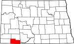
Barnes County 003 Valley City 1875 Dakota Territory judge Alanson H. Barnes 11,775 1,492 sq mi
(3,864 km2)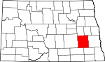
Benson County 005 Minnewaukan 1883 Dakota territorial legislator Bertil W. Benson 6,964 1,389 sq mi
(3,597 km2)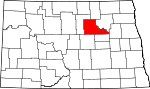
Billings County 007 Medora 1879 Frederick H. Billings, who was president of the Northern Pacific Railroad 888 1,152 sq mi
(2,984 km2)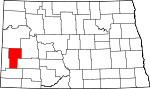
Bottineau County 009 Bottineau 1873 Named for frontiersman Pierre Bottineau 7,149 1,669 sq mi
(4,323 km2)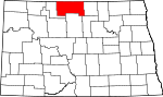
Bowman County 011 Bowman 1883 Dakota territorial legislator Edward M. Bowman 3,242 1,162 sq mi
(3,010 km2)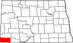
Burke County 013 Bowbells 1910 John Burke, tenth Governor of North Dakota 2,242 1,104 sq mi
(2,859 km2)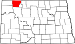
Burleigh County 015 Bismarck 1873 Walter A. Burleigh, territorial delegate to Congress 69,416 1,633 sq mi
(4,229 km2)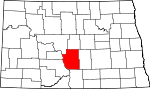
Cass County 017 Fargo 1873 George Washington Cass, who was the president of the Northern Pacific Railroad 123,138 1,766 sq mi
(4,574 km2)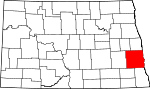
Cavalier County 019 Langdon 1873 Charles Cavalier, French fur trapper and one of the area's original settlers 4,831 1,489 sq mi
(3,856 km2)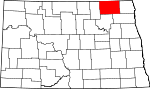
Dickey County 021 Ellendale 1881 Dakota territorial legislator George H. Dickey 5,757 1,131 sq mi
(2,929 km2)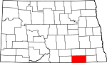
Divide County 023 Crosby 1910 Named because it was created upon the division of Williams County 2,283 1,259 sq mi
(3,261 km2)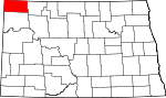
Dunn County 025 Manning 1883 John P. Dunn, an early civic leader of Bismarck, who opened the first drugstore in North Dakota 3,600 2,010 sq mi
(5,206 km2)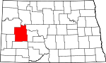
Eddy County 027 New Rockford 1885 Ezra B. Eddy, a Fargo banker and one of the territory's wealthiest citizens 2,757 632 sq mi
(1,637 km2)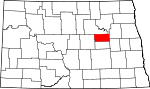
Emmons County 029 Linton 1879 James Emmons, an early entrepreneur and businessman who operated the first steamboat across the Missouri River in Bismarck 4,331 1,510 sq mi
(3,911 km2)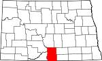
Foster County 031 Carrington 1873 Either James S. Foster and George I. Foster, brother, and prominent farmers during the territorial days 3,759 635 sq mi
(1,645 km2)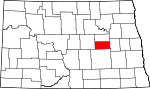
Golden Valley County 033 Beach 1912 Named for either promotional reasons or for the Golden Valley Land and Cattle Company 1,924 1,002 sq mi
(2,595 km2)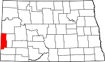
Grand Forks County 035 Grand Forks 1873 Named for Grand Forks, North Dakota, which in turn was named for its location at the intersection of the Red Lake River and the Red River of the North 66,109 1,438 sq mi
(3,724 km2)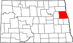
Grant County 037 Carson 1916 Ulysses S. Grant, eighteenth U.S. President 2,841 1,660 sq mi
(4,299 km2)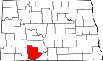
Griggs County 039 Cooperstown 1881 Alexander Griggs, a steamboat captain and founder of Grand Forks, North Dakota 2,754 708 sq mi
(1,834 km2)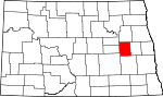
Hettinger County 041 Mott 1883 Mathias K. Hettinger, the father-in-law of Erastus A. Williams, the North Dakota Speaker of the House during that session 2,715 1,132 sq mi
(2,932 km2)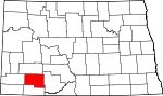
Kidder County 043 Steele 1873 Jefferson Parrish Kidder, territorial delegate to the 44th Congress and 45th Congresses 2,753 1,352 sq mi
(3,502 km2)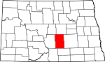
LaMoure County 045 LaMoure 1873 Dakota territorial legislator and North Dakota state legislator Judson LaMoure 4,701 1,147 sq mi
(2,971 km2)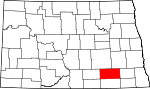
Logan County 047 Napoleon 1873 Illinois U.S. Senator John A. Logan 2,308 993 sq mi
(2,572 km2)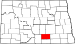
McHenry County 049 Towner 1873 James McHenry, one of the area's original settlers 5,987 1,874 sq mi
(4,854 km2)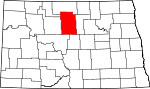
McIntosh County 051 Ashley 1883 Edward H. McIntosh, a member of the Territorial Legislature 3,390 975 sq mi
(2,525 km2)
McKenzie County 053 Watford City 1905 Alexander McKenzie, party boss known in the state as "the senator-maker" 5,737 2,742 sq mi
(7,102 km2)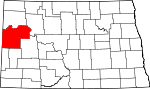
McLean County 055 Washburn 1883 John A. McLean, first mayor of Bismarck, North Dakota 9,311 2,110 sq mi
(5,465 km2)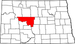
Mercer County 057 Stanton 1875 William Henry Harrison Mercer, an early settler 8,644 1,045 sq mi
(2,707 km2)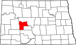
Morton County 059 Mandan 1873 Governor of Indiana Oliver Hazard Perry Throck Morton 25,303 1,926 sq mi
(4,988 km2)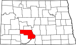
Mountrail County 061 Stanley 1873 Joseph Mountraille, Metis voyageur and early explorer 6,631 1,824 sq mi
(4,724 km2)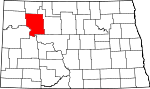
Nelson County 063 Lakota 1883 Dakota territorial legislator Nelson E. Nelson 3,715 982 sq mi
(2,543 km2)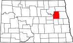
Oliver County 065 Center 1885 Dakota territorial legislator Harry S. Oliver 2,065 724 sq mi
(1,875 km2)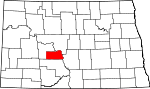
Pembina County 067 Cavalier 1867 Named for the high-bush cranberries which grew wild in the area. Pembina may be from an Ojibwa phrase, anepeminan sipi, referring to the berries, as they grew in abundance around the Redberry River; it may also be from an Ojibwa word meaning meeting place. The name originally applied to the old Pembina Territory 8,585 1,119 sq mi
(2,898 km2)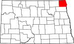
Pierce County 069 Rugby 1887 Gilbert Ashville Pierce, a Governor of Dakota Territory and later a U.S. Senator from North Dakota 4,675 1,018 sq mi
(2,637 km2)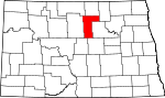
Ramsey County 071 Devils Lake 1873 Minnesota U.S. Senator Alexander Ramsey 12,066 1,186 sq mi
(3,072 km2)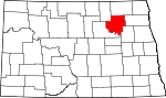
Ransom County 073 Lisbon 1873 Named for locally situated Fort Ransom 5,890 863 sq mi
(2,235 km2)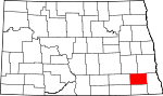
Renville County 075 Mohall 1873 Joseph Renville, missionary and interpreter for Dakota Native Americans 2,610 875 sq mi
(2,266 km2)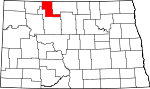
Richland County 077 Wahpeton 1873 Morgan T. Rich, early settler 17,998 1,437 sq mi
(3,722 km2)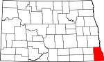
Rolette County 079 Rolla 1873 Joseph Rolette, Jr., a prominent fur trapper and local political organizer 13,674 902 sq mi
(2,336 km2)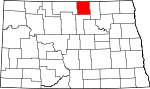
Sargent County 081 Forman 1883 Homer E. Sargent, a general manager of the Northern Pacific Railroad 4,366 859 sq mi
(2,225 km2)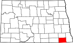
Sheridan County 083 McClusky 1873 American Civil War officer Philip Henry Sheridan 1,710 972 sq mi
(2,517 km2)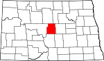
Sioux County 085 Fort Yates 1915 The Native American Sioux people 4,044 1,094 sq mi
(2,833 km2)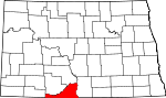
Slope County 087 Amidon 1915 Topographical feature within the county known as the Missouri Slope 767 1,218 sq mi
(3,155 km2)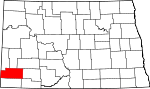
Stark County 089 Dickinson 1879 George Stark, a vice president of the Northern Pacific Railroad 22,636 1,338 sq mi
(3,465 km2)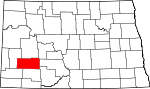
Steele County 091 Finley 1883 Edward H. Steele, secretary-treasurer of the Red River Land Company 2,258 712 sq mi
(1,844 km2)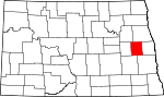
Stutsman County 093 Jamestown 1873 Dakota Territorial Legislator Enos Stutsman 21,908 2,222 sq mi
(5,755 km2)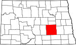
Towner County 095 Cando 1883 Dakota territorial legislator Oscar M. Towner 2,876 1,025 sq mi
(2,655 km2)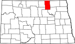
Traill County 097 Hillsboro 1875 Walter John Strickland Traill, early settler 8,477 862 sq mi
(2,233 km2)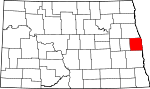
Walsh County 099 Grafton 1881 George H. Walsh, early settler and one of the founders of the University of North Dakota 12,389 1,282 sq mi
(3,320 km2)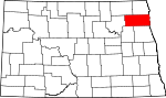
Ward County 101 Minot 1888 Dakota territorial legislator Mark Ward 58,795 2,013 sq mi
(5,214 km2)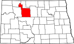
Wells County 103 Fessenden 1873 Dakota territorial legislator Edward Payson Wells 5,102 1,271 sq mi
(3,292 km2)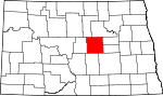
Williams County 105 Williston 1890 Dakota territorial legislator Erastus Appelman Williams 19,761 2,071 sq mi
(5,364 km2)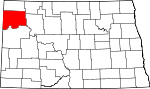
See also
References
- ^ "FIPS Publish 6-4". National Institute of Standards and Technology. http://www.itl.nist.gov/fipspubs/fip6-4.htm. Retrieved 2008-02-03.
- ^ a b "EPA County FIPS Code Listing". US Environmental Protection Agency. http://www.epa.gov/enviro/html/codes/nd.html. Retrieved 2008-02-03.
- ^ a b c d "NACo - Find a county". National Association of Counties. Archived from the original on 2007-10-25. http://web.archive.org/web/20071025113107/http://www.naco.org/Template.cfm?Section=Find_a_County&Template=/cffiles/counties/state.cfm&state.cfm&statecode=ND. Retrieved 2008-02-06.
- ^ ND Cos. Histories
- ^ a b "North Dakota QuickFacts". U.S. Census Bureau. http://quickfacts.census.gov/qfd/maps/north_dakota_map.html. Retrieved 2008-02-06. (2000 Census)
 State of North Dakota
Topics - Climate
- Colleges and universities
- Cuisine
- Delegations
- Geography
- Governors
- History
- Music
- People
- Visitor Attractions
Society Regions - Badlands
- Missouri Plateau
- Drift Prairie
- Red River Valley
- Turtle Mountains
Larger cities
pop. over 5,000Smaller cities
pop. 1,000 - 5,000- Beach
- Beulah
- Bottineau
- Bowman
- Burlington
- Cando
- Carrington
- Casselton
- Cavalier
- Cooperstown
- Crosby
- Ellendale
- Garrison
- Grafton
- Hankinson
- Harvey
- Hazen
- Hettinger
- Hillsboro
- Horace
- Kenmare
- Langdon
- Larimore
- Lincoln
- Linton
- Lisbon
- Mayville
- New Rockford
- New Town
- Oakes
- Park River
- Rolla
- Rugby
- Stanley
- Thompson
- Tioga
- Velva
- Walhalla
- Washburn
- Watford City
- Wishek
Counties - Adams
- Barnes
- Benson
- Billings
- Bottineau
- Bowman
- Burke
- Burleigh
- Cass
- Cavalier
- Dickey
- Divide
- Dunn
- Eddy
- Emmons
- Foster
- Golden Valley
- Grand Forks
- Grant
- Griggs
- Hettinger
- Kidder
- LaMoure
- Logan
- McHenry
- McIntosh
- McKenzie
- McLean
- Mercer
- Morton
- Mountrail
- Nelson
- Oliver
- Pembina
- Pierce
- Ramsey
- Ransom
- Renville
- Richland
- Rolette
- Sargent
- Sheridan
- Sioux
- Slope
- Stark
- Steele
- Stutsman
- Towner
- Traill
- Walsh
- Ward
- Wells
- Williams
Categories:- Lists of U.S. counties by state
- North Dakota counties
- North Dakota-related lists


Wikimedia Foundation. 2010.