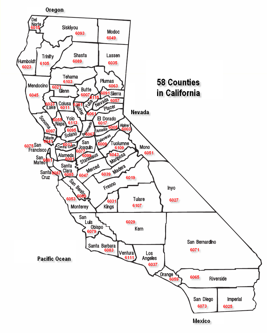
- List of counties in California
-
The U.S. state of California is divided into 58 counties. Counties are responsible for all elections, property-tax collection, maintenance of public records such as deeds, and local-level courts within their borders, as well as providing law enforcement (through the county sheriff and sheriff's deputies) to areas that do not lie within incorporated cities.
- The county is the default unit of local government (all parts of the state's land are allocated to one of the state's 58 counties). Each county has a Board of Supervisors and is subject to mandatory duties under state law to provide its residents with services like law enforcement, healthcare, road maintenance, and so on. Balancing a county's mandatory and discretionary duties is a very difficult task; any sufficiently injured county taxpayer has standing to sue the county to enforce certain duties where financial distress is no excuse, such as healthcare.
- Residents of a sufficiently large piece of unincorporated county land can incorporate a city. The city government then takes some of the tax revenue that would have gone to the county, and can impose additional taxes on its residents. It can then choose to provide almost all the services usually provided by the county (and more), or provide only a few and pay the county to do the rest. A city in this last arrangement is called a contract city; this type of contract is generally known among lawyers as the "Lakewood Plan", because it was pioneered by the city of Lakewood in 1954.[1]
- The idea of "opting out" of county control in California has been taken to its logical extremes. Almost all of the city of Vernon is one large industrial zone, while almost all of the town of Los Altos Hills is zoned as residential.
- Due to geographical variations in property tax and sales tax revenue (the primary revenue source for cities and counties) and differing attitudes towards priorities, there are variations in the levels of various services from one city to the next. For example, the city of Santa Monica is far more generous when it comes to helping the homeless than other cities in Los Angeles County or the county government.
- Also, county ordinances do not apply to cities unless they are ratified by each individual city. Thus, for instance, in Los Angeles County, a few cities have not ratified the ordinance requiring the posting of restaurant inspection ratings—even though it was passed many years ago—and in those cities, ratings need not be posted.
- One consolidated city–county is located in the state, San Francisco. The city's board of supervisors govern both aspects, and there is both a city police department and a county sheriff, the latter mostly responsible for operating the county jail.
Contents
First establishment of California counties
 County FIPS code of California
On January 4, 1850, the California constitutional committee recommended the formation of 18 counties. They were Benicia, Butte, Fremont, Los Angeles, Mariposa, Monterey, Mount Diablo, Oro, Redding, Sacramento, San Diego, San Francisco, San Joaquin, San Jose, San Luis Obispo, Santa Barbara, Sonoma, and Sutter. On April 22, the counties of Branciforte, Calaveras, Coloma, Colusi, Marin, Mendocino, Napa, Trinity, and Yuba were added. Benicia was renamed Solano, Coloma to El Dorado, Fremont to Yolo, Mt. Diablo to Contra Costa, San Jose to Santa Clara, Oro to Tuolumne, and Redding to Shasta. One of the first state legislative acts regarding counties was to rename Branciforte County to Santa Cruz, Colusi to Colusa, and Yola to Yolo.
The last county in California to be established is Imperial County on August 7, 1907.
California's postal abbreviation is CA and its FIPS state code is 06.
List
County FIPS code
[2]County seat
[3]Established
[3]Formed from Etymology
[4]Population Area
[3]Map Alameda County 001 Oakland 1853 Contra Costa and Santa Clara Spanish for "avenue shaded by trees" or "cottonwood grove." 1,510,271 738 sq mi
(1,911 km2)
Alpine County 003 Markleeville 1864 Amador, El Dorado, Calaveras, Mono and Tuolumne Location high in the Sierra Nevada. 1,175 739 sq mi
(1,914 km2)
Amador County 005 Jackson 1854 Calaveras Jose Maria Amador (1794-1883), a soldier, rancher, and miner who, along with several Native Americans, established a successful gold mining camp near present-day Amador City in 1848. 38,091 593 sq mi
(1,536 km2)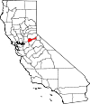
Butte County 007 Oroville 1850 Original Sutter Buttes, mistakenly thought to be in the county during the county's establishment. 220,000 1,640 sq mi
(4,248 km2)
Calaveras County 009 San Andreas 1850 Original Calaveras River; calaveras is Spanish for "skulls." 45,578 1,020 sq mi
(2,642 km2)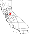
Colusa County 011 Colusa 1850 Original Rancho Colus land grant from Mexico. 21,419 1,151 sq mi
(2,981 km2)
Contra Costa County 013 Martinez 1850 Original Spanish for "opposite coast," from its location across San Francisco Bay from San Francisco. 1,049,025 720 sq mi
(1,865 km2)
Del Norte County 015 Crescent City 1857 Klamath Spanish for "northern," from its far northern location. 28,610 1,008 sq mi
(2,611 km2)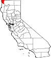
El Dorado County 017 Placerville 1850 Original El Dorado, a mythical city of gold, owing to the area's importance in the California Gold Rush. 181,058 1,712 sq mi
(4,434 km2)
Fresno County 019 Fresno 1856 Mariposa, Merced and Tulare Fresno Creek; fresno is Spanish for "ash tree." 930,450 5,963 sq mi
(15,444 km2)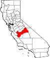
Glenn County 021 Willows 1891 Colusa Dr. Hugh J. Glenn, a California businessman and politician. 28,122 1,315 sq mi
(3,406 km2)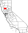
Humboldt County 023 Eureka 1853 Trinity Humboldt Bay, named after Alexander von Humboldt, a German naturalist and explorer. 134,623 3,573 sq mi
(9,254 km2)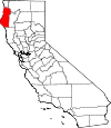
Imperial County 025 El Centro 1907 San Diego Imperial Valley, named for the Imperial Land Company. 174,528 4,175 sq mi
(10,813 km2)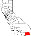
Inyo County 027 Independence 1866 Mono and Tulare Disputed original; early settlers believed Inyo to be the native name for area mountains, but this term may be the name of a Mono Indian leader 18,546 10,192 sq mi
(26,397 km2)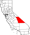
Kern County 029 Bakersfield 1866 Los Angeles and Tulare Kern River, named for Edward Kern, cartographer for John C. Fremont's 1845 expedition. 839,631 8,142 sq mi
(21,088 km2)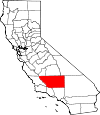
Kings County 031 Hanford 1893 Tulare Kings River, original Spanish name Rio de los Santos Reyes ("River of the Holy Kings"). 152,982 1,390 sq mi
(3,600 km2)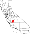
Lake County 033 Lakeport 1861 Napa Clear Lake 64,665 1,258 sq mi
(3,258 km2)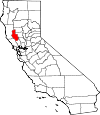
Lassen County 035 Susanville 1864 Plumas and Shasta, and now defunct Lake County, Nevada Peter Lassen, a Danish naturalist and explorer. 34,895 4,558 sq mi
(11,805 km2)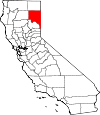
Los Angeles County 037 Los Angeles 1850 Original Spanish for "The Angels," abbreviated from El Pueblo de Nuestra Señora la Reina de los Angeles del Río de Porciúncula (The Village of Our Lady, the Queen of the Angels of the river of Porziuncola). 9,818,605 4,060 sq mi
(10,515 km2)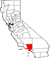
Madera County 039 Madera 1893 Mariposa Spanish for "wood", in reference to the forested area of the landscape 150,865 2,138 sq mi
(5,537 km2)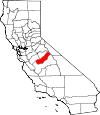
Marin County 041 San Rafael 1850 Original Disputed, but could be a corrupted abbreviation of Bahía de Nuestra Señora del Rosario la Marina, the Spanish name for area headlands along San Francisco Bay. 252,409 520 sq mi
(1,347 km2)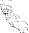
Mariposa County 043 Mariposa 1850 Original Spanish for "butterfly." 18,251 1,451 sq mi
(3,758 km2)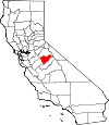
Mendocino County 045 Ukiah 1850 Original Antonio de Mendoza, first viceroy of New Spain. 87,841 3,509 sq mi
(9,088 km2)
Merced County 047 Merced 1855 Mariposa Merced River; original Spanish name El Río de Nuestra Señora de la Merced ("River of Our Lady of Mercy"). 255,793 1,929 sq mi
(4,996 km2)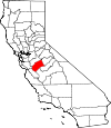
Modoc County 049 Alturas 1874 Siskiyou The Modoc people 9,686 3,944 sq mi
(10,215 km2)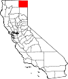
Mono County 051 Bridgeport 1861 Calaveras, Fresno and Mariposa Mono Lake; name derived from Monachi, a Yokut name for native peoples of the Sierra Nevada. 14,202 3,044 sq mi
(7,884 km2)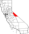
Monterey County 053 Salinas 1850 Original Monterey Bay, Spanish portmanteau of monte ("hill") and rey ("king"). 415,057 3,322 sq mi
(8,604 km2)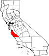
Napa County 055 Napa 1850 Original Disputed origin; possibly derived from the Patwin word napo, meaning home. 136,484 754 sq mi
(1,953 km2)
Nevada County 057 Nevada City 1851 Yuba Spanish for "snow-covered," referrencing the area's high elevation 98,764 958 sq mi
(2,481 km2)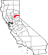
Orange County 059 Santa Ana 1889 Los Angeles The orange, which was widely grown in the area at the time the county was established. 3,010,232 790 sq mi
(2,046 km2)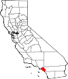
Placer County 061 Auburn 1851 Sutter and Yuba Spanish term for gravel deposits that contain gold; references the California Gold Rush, which was centered in the area. 348,432 1,503 sq mi
(3,893 km2)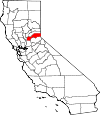
Plumas County 063 Quincy 1854 Butte Feather River; Spanish name El Rio de las Plumas. 20,007 2,554 sq mi
(6,615 km2)
Riverside County 065 Riverside 1893 San Bernardino and San Diego The city of Riverside, named for its location on the Santa Ana River. 2,189,641 7,208 sq mi
(18,669 km2)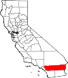
Sacramento County 067 Sacramento 1850 Original Sacramento River, named for the Santisimo Sacramento (Spanish for "Most Holy Sacrament"). 1,418,788 966 sq mi
(2,502 km2)
San Benito County 069 Hollister 1874 Monterey Saint Benedict (San Benedicto in Spanish; Benito is the diminutive of Benedicto). 55,269 1,389 sq mi
(3,597 km2)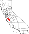
San Bernardino County 071 San Bernardino 1853 Los Angeles City of San Bernardino, named for Saint Bernardino of Siena (San Bernardino de Siena in Spanish) 2,035,210 20,062 sq mi
(51,960 km2)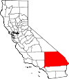
San Diego County 073 San Diego 1850 Original Spanish for Saint Didacus 3,095,313 4,204 sq mi
(10,888 km2)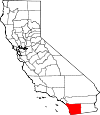
San Francisco County 075 San Francisco 1850 Original Spanish for Saint Francis. 805,235 47 sq mi
(122 km2)
San Joaquin County 077 Stockton 1850 Original Spanish for Saint Joachim. 685,306 1,399 sq mi
(3,623 km2)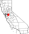
San Luis Obispo County 079 San Luis Obispo 1850 Original Spanish for Saint Louis, the Bishop. 269,637 3,304 sq mi
(8,557 km2)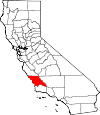
San Mateo County 081 Redwood City 1856 San Francisco Spanish for Saint Matthew. 718,451 449 sq mi
(1,163 km2)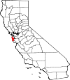
Santa Barbara County 083 Santa Barbara 1850 Original Spanish for Saint Barbara. 423,895 2,738 sq mi
(7,091 km2)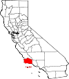
Santa Clara County 085 San Jose 1850 Original Spanish for Saint Clare. 1,781,642 1,291 sq mi
(3,344 km2)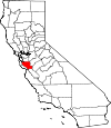
Santa Cruz County 087 Santa Cruz 1850 Original Mission Santa Cruz 262,382 446 sq mi
(1,155 km2)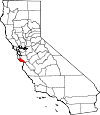
Shasta County 089 Redding 1850 Original Mount Shasta 177,223 3,786 sq mi
(9,806 km2)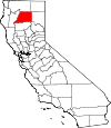
Sierra County 091 Downieville 1852 Yuba Spanish for "mountain range," referencing the area's topography 3,240 953 sq mi
(2,468 km2)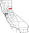
Siskiyou County 093 Yreka 1852 Shasta and Klamath Siskiyou Mountains; etymology of Siskiyou is disputed. 44,900 6,287 sq mi
(16,283 km2)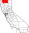
Solano County 095 Fairfield 1850 Original Chief Solano of the Suisunes 413,344 828 sq mi
(2,145 km2)
Sonoma County 097 Santa Rosa 1850 Original Disputed origin; possibly a Pomo term meaning "valley of the moon," which references a native legend about spiritual activity in the area. 483,878 1,576 sq mi
(4,082 km2)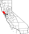
Stanislaus County 099 Modesto 1854 Tuolumne Stanislaus River, named for Estanislao. 514,453 1,495 sq mi
(3,872 km2)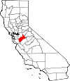
Sutter County 101 Yuba City 1850 Original John Sutter, a Swiss pioneer of California associated with the California Gold Rush. 94,737 603 sq mi
(1,562 km2)
Tehama County 103 Red Bluff 1856 Butte, Colusa and Shasta The Tehama people, a local Native American tribe. 63,463 2,951 sq mi
(7,643 km2)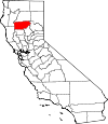
Trinity County 105 Weaverville 1850 Original The Trinity River, named for the town of Trinidad (Spanish for "Trinity"). 13,786 3,179 sq mi
(8,234 km2)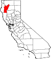
Tulare County 107 Visalia 1852 Mariposa Tulare Lake 442,179 4,824 sq mi
(12,494 km2)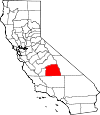
Tuolumne County 109 Sonora 1850 Original Disputed origin; possibly a corruption of the native term talmalamne, which means cluster of stone wigwams and references local cave dwelling tribes 55,365 2,236 sq mi
(5,791 km2)
Ventura County 111 Ventura 1872 Santa Barbara Abbreviation of San Buenaventura, Spanish for St. Bonaventure. 823,318 1,846 sq mi
(4,781 km2)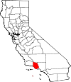
Yolo County 113 Woodland 1850 Original The Yolan people, a local Native American tribe. 200,849 1,012 sq mi
(2,621 km2)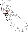
Yuba County 115 Marysville 1850 Original The Yuba family, who owned ranches in the Sacramento River Valley. 72,155 630 sq mi
(1,632 km2)
Defunct counties
- Klamath County was created in 1851 from the northern half of Trinity County. Part of the county's territory went to Del Norte County in 1857, and in 1874 the remainder was divided between Humboldt and Siskiyou counties.
- Pautah County was created in 1852 out of territory which, the state of California assumed, was to be ceded to it by the United States Congress from territory in what is now the state of Nevada. When the cession never occurred, the California State Legislature officially abolished the never-created county in 1859.
Failed attempts to organize Counties
- Buena Visa County 1855-1859 (later Kern County).
- Coso County 1864 (later Inyo County).
- San Antonio County in the late 1870s/early 1880s of eastern Los Angeles and southwest San Bernardino counties.
- Desert County in 1943-1946 of eastern Riverside county. See also Cahuilla County, California attempt in the late 1980s.
- High Desert County in 2003-2006 period to encompass northern Los Angeles, western San Bernardino and eastern Kern counties.
County Secession proposals
- Corona County in southwest Riverside County.
- Mission County in northern Santa Barbara County.
- Northern or Del Sur County in San Diego County.
- Ocean County in western Mendocino County.
- Redwood County in western Sonoma County.
- Southern or San Juan/Capristrano County in Orange County.
- Tahoe County would encompass the Lake Tahoe area made up of eastern parts of El Dorado, Placer, Sierra and Nevada counties.
City-County-Borough proposals
- Los Angeles with city secessionism and county secessionism, or to consolidate the city and county governments, then modeled them after the Borough system of New York City, and create 5 or 6 city-county governments: San Fernando Valley; San Gabriel Valley; Long Beach with southeast Los Angeles County; South Bay, Los Angeles; West Los Angeles; and Hollywood, California separately from Downtown; and the inner core of Los Angeles.
See also
Notes
- ^ Reynolds, 48-49.
- ^ "EPA County FIPS Code Listing". EPA.gov. http://www.epa.gov/enviro/html/codes/ca.html. Retrieved February 23, 2008.
- ^ a b c National Association of Counties. "NACo - Find a county". http://www.naco.org/Template.cfm?Section=Find_a_County&Template=/cffiles/counties/state.cfm&state.cfm&statecode=CA. Retrieved April 30, 2008.
- ^ Sanchez, Nellie Van de Grift (1914). Spanish and Indian Place Names of California: Their Meaning and Their Romance. San Francisco: A. M. Robertson. OCLC 4268886. http://books.google.com/books?id=gKgYAAAAIAAJ.
External links
- California State Association of Counties
- State map showing the county names and linking to county data
- California County Formation Maps; n2genealogy.com Shows the changing boundaries of the Counties from 1850 to 1925.
- California State Association of Counties, Map of California Counties: circa 1850
- California State Association of Counties, Map of California Counties: circa 1860
- California State Association of Counties, Map of California Counties: circa 1870
- California State Association of Counties, Map of California Counties: circa 1880
- California State Association of Counties, Map of California Counties: circa 1900
- California State Association of Counties, Map of California Counties: circa 1907-Present
 State of California
Sacramento (capital) Topics Climate · Delegations · Deserts · Districts · Ecology · Elections · Environment · Geography · Government · History · Protected areas · Sports · Symbols · Transportation · Visitor attractions · Index of California-related articles
Society Californians · Culture · Crime · Demographics · Economy · Education · Politics
Regions Antelope Valley · Big Sur · Cascade Range · Central California · Central Coast · Central Valley · Channel Islands · Coachella Valley · Conejo Valley · Cucamonga Valley · Death Valley · East Bay (SF) · East County (SD) · Eastern California · Emerald Triangle · Gold Country · Great Basin · Greater Los Angeles · Greater Sacramento · Inland Empire · Lake Tahoe · Los Angeles Basin · Lost Coast · Metropolitan Fresno · Mojave · Mountain Empire · North Bay (SF) · North Coast · North County (SD) · Northern California · Owens Valley · Oxnard Plain · San Francisco Peninsula · Pomona Valley · Sacramento Valley · San Bernardino Valley · San Diego–Tijuana · San Fernando Valley · San Francisco Bay Area · San Gabriel Valley · San Joaquin Valley · Santa Clara Valley · Santa Clara River Valley · Santa Clarita Valley · Shasta Cascade · Sierra Nevada · Silicon Valley · South Bay (LA) · South Bay (SF) · South Bay (SD) · South Coast · Southern California · Southern Border Region · Tri-Valley · Upstate California · Victor Valley · Wine Country · Yosemite
Metro areas Bakersfield · Chico · El Centro · Fresno · Hanford–Corcoran · Los Angeles–Long Beach–Glendale · Madera · Modesto · Merced · Napa · Oakland–Fremont–Hayward · Oxnard–Thousand Oaks–Ventura · Redding · Riverside–San Bernardino–Ontario · Sacramento–Arden Arcade–Roseville · Salinas · San Diego–Carlsbad–San Marcos · San Francisco–San Mateo–Redwood City · San Jose–Sunnyvale–Santa Clara · San Luis Obispo–Paso Robles · Santa Ana–Anaheim–Irvine · Santa Barbara–Santa Maria–Goleta · Santa Cruz–Watsonville · Santa Rosa–Petaluma · Stockton · Vallejo–Fairfield · Visalia–Porterville · Yuba City
Micro areas Counties Alameda · Alpine · Amador · Butte · Calaveras · Colusa · Contra Costa · Del Norte · El Dorado · Fresno · Glenn · Humboldt · Imperial · Inyo · Kern · Kings · Lake · Lassen · Los Angeles · Madera · Marin · Mariposa · Mendocino · Merced · Modoc · Mono · Monterey · Napa · Nevada · Orange · Placer · Plumas · Riverside · Sacramento · San Benito · San Bernardino · San Diego · San Francisco · San Joaquin · San Luis Obispo · San Mateo · Santa Barbara · Santa Clara · Santa Cruz · Shasta · Sierra · Siskiyou · Solano · Sonoma · Stanislaus · Sutter · Tehama · Trinity · Tulare · Tuolumne · Ventura · Yolo · Yuba
Categories:- Lists of U.S. counties by state
- California counties
- California-related lists


Wikimedia Foundation. 2010.