- List of counties in Idaho
-

This is a list of 44 counties in the U.S. state of Idaho.
Each county in Idaho has a license plate prefix, according to the first letter of the county name. The first county for a given letter is given #1, the second county #2, etc. For example, Ada and Adams are the only two counties with the letter 'A'. Since Ada comes before Adams alphabetically, Ada is '1A' while Adams is '2A.' There are four counties that start with the letter 'L': Latah, Lemhi, Lewis, and Lincoln; the license plate prefixes for these counties are 1L, 2L, 3L, and 4L, respectively.
Elmore, Idaho, Kootenai, Nez Perce, Shoshone, Valley, and Washington counties are the only ones in the state with those beginning letters. Therefore, the license plate prefix would be the first letter of the county name, without a number. The letter 'B' has ten counties, 'C' has seven, and 'L' has four; the remaining letters have two or fewer.
Alphabetical list
County FIPS code
[1]County seat
[2]Established
[2]Origin
[3]Etymology
[4]Population
[2][5]Area
[2][5]Map Ada County 001 Boise 1864 Boise County Ada Riggs, daughter of H. C. Riggs, a member of the Idaho Territorial Legislature. 300,904 1,055 sq mi
(2,732 km2)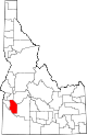
Adams County 003 Council 1911 Washington County John Adams (1735-1826), second President of the United States (1797-1801). 3,476 1,365 sq mi
(3,535 km2)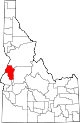
Bannock County 005 Pocatello 1893 Bingham County Bannock Native American tribe. 75,565 1,113 sq mi
(2,883 km2)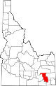
Bear Lake County 007 Paris 1893 Oneida County Bear Lake on the Utah/Idaho border. 6,411 971 sq mi
(2,515 km2)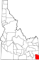
Benewah County 009 St. Maries 1915 Kootenai County Benewah, chief of the Coeur d'Alene Tribe 9,171 776 sq mi
(2,010 km2)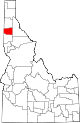
Bingham County 011 Blackfoot 1885 Oneida County Henry H. Bingham (1841-1912), American Civil War general and Congressman from Pennsylvania. 41,735 2,095 sq mi
(5,426 km2)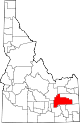
Blaine County 013 Hailey 1895 Alturas County James G. Blaine (1830-1893), United States Secretary of State (1881, 1889-1892). 18,991 2,645 sq mi
(6,851 km2)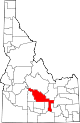
Boise County 015 Idaho City 1864 Original county Boise River 6,670 1,902 sq mi
(4,926 km2)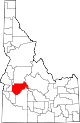
Bonner County 017 Sandpoint 1907 Kootenai County Edwin L. Bonner, originator of a 1864 ferry service on the Kootenai River. 36,835 1,738 sq mi
(4,501 km2)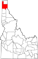
Bonneville County 019 Idaho Falls 1911 Bingham County Benjamin Bonneville (1796-1878), French-born explorer of the American West. 82,522 1,869 sq mi
(4,841 km2)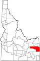
Boundary County 021 Bonners Ferry 1915 Bonner Borders Canada on the north. 9,871 1,269 sq mi
(3,287 km2)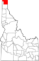
Butte County 023 Arco 1917 Bingham, Blaine, and Jefferson counties Buttes rising from the Snake River Plain. 2,899 2,233 sq mi
(5,783 km2)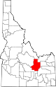
Camas County 025 Fairfield 1917 Blaine County Camassia, a plant species important as a food source among Native Americans and early settlers. 991 1,075 sq mi
(2,784 km2)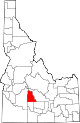
Canyon County 027 Caldwell 1892 Ada County Disputed, either a canyon of the Boise River near Caldwell or a canyon of the Snake River which forms part of the county's boundary. 131,441 590 sq mi
(1,528 km2)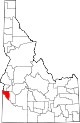
Caribou County 029 Soda Springs 1919 Bannock County Caribou Mountains 7,304 1,766 sq mi
(4,574 km2)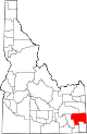
Cassia County 031 Burley 1879 Owyhee County Disputed, either Cassia Creek or Mormon Battalion member James John Cazier. 21,416 2,567 sq mi
(6,648 km2)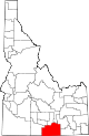
Clark County 033 Dubois 1919 Fremont County Sam K. Clark, early settler and member of the Idaho Senate. 1,022 1,765 sq mi
(4,571 km2)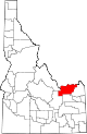
Clearwater County 035 Orofino 1911 Nez Perce County Clearwater River 8,930 2,462 sq mi
(6,377 km2)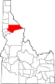
Custer County 037 Challis 1881 Alturas and Lemhi counties General Custer mine, named after George Armstrong Custer (1839-1876), United States Army general. 4,342 4,926 sq mi
(12,758 km2)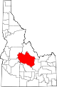
Elmore County 039 Mountain Home 1889 Alturas County Ida Elmore mines, locally noted for gold and silver production in the 1860s. 29,130 3,078 sq mi
(7,972 km2)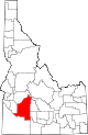
Franklin County 041 Preston 1913 Oneida County Franklin D. Richards (1821-1899), early LDS Church apostle. 11,329 666 sq mi
(1,725 km2)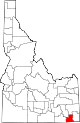
Fremont County 043 Saint Anthony 1893 Bingham County John C. Frémont (1813-1890), American West explorer. 11,819 1,867 sq mi
(4,836 km2)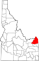
Gem County 045 Emmett 1915 Boise and Canyon counties State nickname of "Gem State." 15,181 563 sq mi
(1,458 km2)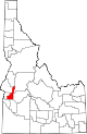
Gooding County 047 Gooding 1913 Lincoln County Frank R. Gooding (1859-1928), seventh Governor of Idaho (1905-1909), U.S. Senator (1921-1928). 14,155 731 sq mi
(1,893 km2)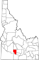
Idaho County 049 Grangeville 1864 Original county Columbia River steamship Idaho launched in 1860. Name predates both Idaho Territory and the State of Idaho. 15,511 8,485 sq mi
(21,976 km2)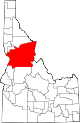
Jefferson County 051 Rigby 1913 Fremont County Thomas Jefferson (1743-1826), third President of the United States (1801-1809). 19,155 1,095 sq mi
(2,836 km2)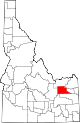
Jerome County 053 Jerome 1919 Gooding and Lincoln counties Disputed, either North Side Irrigation Project developer Jerome Hill, his son-in-law Jerome Kuhn, or his grandson Jerome Kuhn, Jr. 18,342 600 sq mi
(1,554 km2)
Kootenai County 055 Coeur d'Alene 1864 Nez Perce County Kootenai Native American tribe. 108,685 1,245 sq mi
(3,225 km2)
Latah County 057 Moscow 1888 Nez Perce County Latah Creek, Nez Perce for "the place of pine trees and sestle." 34,935 1,077 sq mi
(2,789 km2)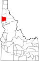
Lemhi County 059 Salmon 1869 Idaho County Limhi, king of the Nephites according to the Book of Mormon. 7,806 4,564 sq mi
(11,821 km2)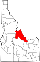
Lewis County 061 Nezperce 1911 Nez Perce County Meriwether Lewis (1774-1809), leader of the Lewis and Clark Expedition. 3,747 479 sq mi
(1,241 km2)
Lincoln County 063 Shoshone 1895 Logan County Abraham Lincoln (1809-1865), sixteenth President of the United States (1861-1865). Idaho Territory was founded under Lincoln's administration. 4,044 1,206 sq mi
(3,124 km2)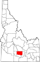
Madison County 065 Rexburg 1913 Fremont County James Madison (1751-1836), fourth President of the United States (1809-1817). 27,467 472 sq mi
(1,222 km2)
Minidoka County 067 Rupert 1913 Lincoln County Disputed Native American origin, either Lakota for "a fountain or spring of water" or Shoshoni for "broad expanse." 20,174 760 sq mi
(1,968 km2)
Nez Perce County 069 Lewiston 1864 Original county Nez Perce Native American tribe. 37,410 849 sq mi
(2,199 km2)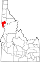
Oneida County 071 Malad City 1864 Original County Oneida Lake in New York state, where many early settlers were from. 4,125 1,200 sq mi
(3,108 km2)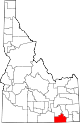
Owyhee County 073 Murphy 1863 Original county Corruption of Hawaii. Hawaiian fur trappers explored the area in 1819 and 1820. 10,644 7,678 sq mi
(19,886 km2)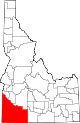
Payette County 075 Payette 1917 Canyon County Francois Payette (1793-1844?), Canadian-born fur trader and early settler. 20,578 408 sq mi
(1,057 km2)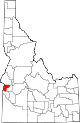
Power County 077 American Falls 1913 Bingham, Blaine, and Oneida counties American Falls Power Plant 7,538 1,406 sq mi
(3,642 km2)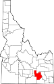
Shoshone County 079 Wallace 1864 Original county Shoshoni Native American tribe. 13,771 2,634 sq mi
(6,822 km2)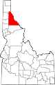
Teton County 081 Driggs 1915 Bingham, Fremont, and Madison counties Teton Range and valley. 5,999 450 sq mi
(1,165 km2)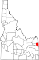
Twin Falls County 083 Twin Falls 1907 Cassia County Twin Falls waterfall on the Snake River. 64,284 1,925 sq mi
(4,986 km2)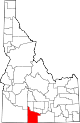
Valley County 085 Cascade 1917 Boise and Idaho counties Long Valley located in the county. 7,651 3,678 sq mi
(9,526 km2)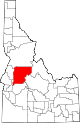
Washington County 087 Weiser 1879 Ada County George Washington (1732-1799), first President of the United States (1789-1797). 9,977 1,456 sq mi
(3,771 km2)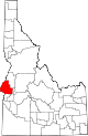
Defunct Idaho counties
- Alturas County: A huge south-central Idaho county formed in 1864. Abolished in 1895.
- Lah-Toh County: North Idaho county formed in 1864. Abolished in 1867.
- Logan County: Formed by an 1889 partition of Alturas County. Abolished in 1895.
References
- ^ "EPA County FIPS Code Listing". EPA.gov. http://www.epa.gov/enviro/html/codes/id.html. Retrieved 2008-02-23.
- ^ a b c d National Association of Counties. "NACo - Find a county". http://www.naco.org/Template.cfm?Section=Find_a_County&Template=/cffiles/counties/state.cfm&state.cfm&statecode=ID. Retrieved 2008-04-26.
- ^ Hailey, John (1910). The History of Idaho. Press of Syms-York company. pp. 305–307. OCLC 5793481. http://books.google.com/books?id=2jvsOU6DSO4C. Retrieved 2008-04-26.
- ^ "List of Idaho Counties - Idaho.gov". State of Idaho. http://www.idaho.gov/aboutidaho/county/index.html. Retrieved 2008-07-30.
- ^ a b "Idaho QuickFacts". U.S. Census Bureau. http://quickfacts.census.gov/qfd/maps/idaho_map.html. Retrieved 2008-04-23. (2000 Census)
 State of Idaho
Topics - Index
- Geography
- Government
- Delegations
- Governors
- History
- Symbols
- Images
- People
- Visitor Attractions
Society Regions Larger
citiesSmaller
citiesCounties - Ada
- Adams
- Bannock
- Bear Lake
- Benewah
- Bingham
- Blaine
- Boise
- Bonner
- Bonneville
- Boundary
- Butte
- Camas
- Canyon
- Caribou
- Cassia
- Clark
- Clearwater
- Custer
- Elmore
- Franklin
- Fremont
- Gem
- Gooding
- Idaho
- Jefferson
- Jerome
- Kootenai
- Latah
- Lemhi
- Lewis
- Lincoln
- Madison
- Minidoka
- Nez Perce
- Oneida
- Owyhee
- Payette
- Power
- Shoshone
- Teton
- Twin Falls
- Valley
- Washington
Categories:- Idaho counties
- Lists of U.S. counties by state


Wikimedia Foundation. 2010.