- Latah County, Idaho
-
Latah County, Idaho 
Seal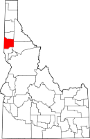
Location in the state of Idaho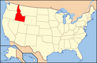
Idaho's location in the U.S.Founded May 14, 1888 Named for Latah Creek Seat Moscow Largest city Moscow Area
- Total
- Land
- Water
1,076.89 sq mi (2,789 km²)
1,076.65 sq mi (2,789 km²)
0.24 sq mi (1 km²), .02%Population
- (2010)
- Density
37,244
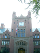
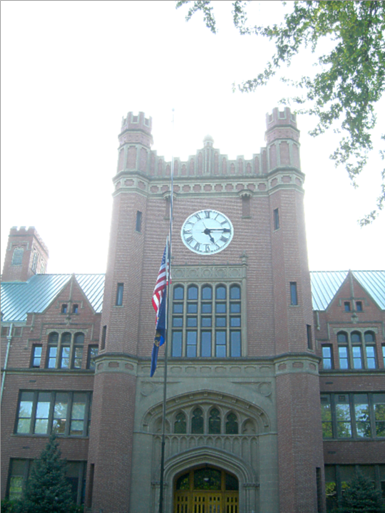
34.6/sq mi (14.0/km²)Time zone Pacific: UTC-8/-7 Website latah.id.us Latah County is a county located in the north central region of the U.S. state of Idaho. The population was 37,244 at the 2010 census.[1] The county seat and largest city is Moscow,[2] which is the home of the University of Idaho, the state's flagship and land-grant university. The county comprises the majority of the eastern portion of the Palouse, famous for its rolling hills and rich agriculture. Latah County is the only county in the U.S. established by an act of Congress.[3]
Latah County (pron. /ˈleɪtə/ lay-tə) was created in 1888 and named for Latah Creek in its northwest corner. The name is Nez Perce and means "the place of pine trees and pestle", because the tribe found stones here suitable for pulverizing camas roots and shade under the white pine trees in which to work.[4]
Latah County comprises the Moscow, ID, Micropolitan Statistical Area.
Contents
Geography
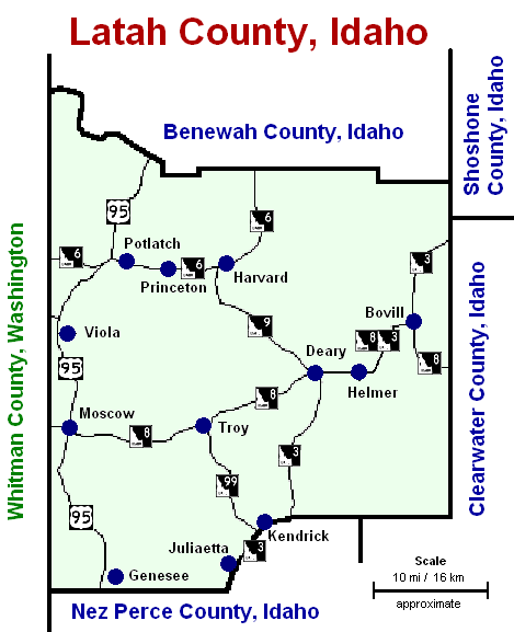
According to the 2000 census, the county has a total area of 1,076.89 square miles (2,789.1 km2), of which 1,076.65 square miles (2,788.5 km2) (or 99.98%) is land and 0.24 square miles (0.62 km2) (or 0.02%) is water.[5] It is part of the Palouse, a wide and rolling portion of the middle Columbia basin.
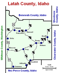
Adjacent counties
- Benewah County - north
- Shoshone County - northeast
- Clearwater County - east
- Nez Perce County - south
- Whitman County, Washington - west

National protected area
- St. Joe National Forest (part)
Highways
Demographics
Historical populations Census Pop. %± 1900 13,451 — 1910 18,818 39.9% 1920 18,092 −3.9% 1930 17,798 −1.6% 1940 18,804 5.7% 1950 20,971 11.5% 1960 21,170 0.9% 1970 24,891 17.6% 1980 28,749 15.5% 1990 30,617 6.5% 2000 34,935 14.1% 2010 37,244 6.6% sources:[1][6] As of the census[7] of 2000, there were 34,935 people, 13,059 households, and 7,770 families residing in the county. The population density was 32 people per square mile (13/km²). There were 13,838 housing units at an average density of 13 per square mile (5/km²). The racial makeup of the county was 93.94% White, 0.59% Black or African American, 0.75% Native American, 2.10% Asian, 0.09% Pacific Islander, 0.77% from other races, and 1.76% from two or more races. 2.12% of the population were Hispanic or Latino of any race. 20.4% were of German, 13.5% English, 8.7% Irish, 7.8% American and 5.9% Norwegian ancestry according to Census 2000.
There were 13,059 households out of which 27.90% had children under the age of 18 living with them, 50.50% were married couples living together, 6.10% had a female householder with no husband present, and 40.50% were non-families. 26.30% of all households were made up of individuals and 6.30% had someone living alone who was 65 years of age or older. The average household size was 2.38 and the average family size was 2.93.
In the county the population was spread out with 20.30% under the age of 18, 24.50% from 18 to 24, 26.90% from 25 to 44, 18.90% from 45 to 64, and 9.50% who were 65 years of age or older. The median age was 28 years. For every 100 females there were 107.50 males. For every 100 females age 18 and over, there were 108.10 males.
The median income for a household in the county was $32,524, and the median income for a family was $46,303. Males had a median income of $34,734 versus $24,886 for females. The per capita income for the county was $16,690. About 7.90% of families and 16.70% of the population were below the poverty line, including 10.20% of those under age 18 and 5.40% of those age 65 or over. Forty percent of all workers in Latah County work for the University of Idaho or Washington State University in nearby Pullman.
Flora and fauna
There are numerous species of plants and animals within Latah County. There are a variety of tree species within the county including Western White Pine.[8] Faunal species include the Clay-colored sparrow[9] and Rough-Skinned Newt.[10]
Government and politics
Latah County has long been one of the most politically competitive counties in Idaho, while the state as a whole is strongly Republican.
Latah County residents voted in the 2000 and 2004 presidential elections for the Republican candidate at a lower rate than the rest of the state. In 2000, George W. Bush carried Latah County with 53.3% of the vote; in 2004, this fell to 49.5% of the vote as the Democratic vote share increased from 37.0% to 48.0%. Ralph Nader, who received 6.5% of the vote in 2000, was not on the ballot in 2004. In 2008, Barack Obama carried the county over John McCain 51.9%-45.1%. In 2006, Latah County voted 55.05% against HJR 2, which amended the Idaho Constitution to outlaw same-sex marriage; the measure passed with 63.35% of the statewide vote. Blaine County, a very popular ski resort area and Idaho's one Democratic stronghold, was the one other county to reject HJR 2.[11]
On the precinct level, Democrats generally carry the university city of Moscow by moderate margins,
and the rural remainder of the county is strongly Republican.[12]Communities
Cities
Name Population
(2000)Elevation Zip Code Coordinates Notes Bovill 305 2874 ft - (876 m) 83806 46°51′33″N 116°23′40″W / 46.85917°N 116.39444°W Deary 552 2874 ft - (876 m) 83823 46°48′0″N 116°33′31″W / 46.8°N 116.55861°W Genesee 946 2680 ft - (817 m) 83832 46°33′4″N 116°55′39″W / 46.55111°N 116.9275°W Juliaetta 609 1171 ft - (357 m) 83535 46°34′40″N 116°42′28″W / 46.57778°N 116.70778°W Kendrick 369 1240 ft - (378 m) 83537 46°36′52″N 116°39′1″W / 46.61444°N 116.65028°W Moscow 21,291 2579 ft - (786 m) 83843 46°43′54″N 116°59′50″W / 46.73167°N 116.99722°W county seat Onaway 230 2621 ft - (799 m) 83855 46°55′43″N 116°53′21″W / 46.92861°N 116.88917°W Potlatch 791 2546 ft - (776 m) 83855 46°55′20″N 116°53′52″W / 46.92222°N 116.89778°W Troy 798 2487 ft - (758 m) 83871 46°44′19″N 116°46′15″W / 46.73861°N 116.77083°W TOTAL 25,891 Unincorporated community
According to the 2000 census, the population in the unincorporated areas of Latah County was 9,044,
which was 25.9% of the county's population.See also
Notes
- ^ a b Quickfacts.census.gov - Latah County - accessed 2011-10-08.
- ^ "Find a County". National Association of Counties. http://www.naco.org/Counties/Pages/FindACounty.aspx. Retrieved 2011-06-07.
- ^ Latah County - history
- ^ Idaho.gov - Latah County - accessed 2009-06-06
- ^ "Census 2000 U.S. Gazetteer Files: Counties". United States Census. http://www.census.gov/tiger/tms/gazetteer/county2k.txt. Retrieved 2011-02-13.
- ^ census.gov Idaho population by county, 1900-90 - accessed 2009-06-06
- ^ "American FactFinder". United States Census Bureau. http://factfinder.census.gov. Retrieved 2008-01-31.
- ^ Julie R. Monroe (2006) Latah County, Arcadia Publishing, 127 pages ISBN 0-7385-3133-2
- ^ Shirley Shurts, 2006, A Comprehensive List of Review Species Reports in Idaho
- ^ C. Michael Hogan (2008) Rough-skinned Newt ("Taricha granulosa"), GlobalTwitcher, ed. N. Stromberg [1]
- ^ Idaho HJR 2 Results by County
- ^ "Idaho Election Results". Idaho Secretary Of State: Elections, Campaign Disclosure and Lobbyists. Idaho Secretary of State. http://www.idsos.state.id.us/ELECT/results.htm. Retrieved 2007-05-02.
External links
- Latah County - official site
- Access Idaho - Latah County
- Latah County Historical Society
- Latah Trail Project
- National Register of Historic Places - Latah County

Benewah County Shoshone County Whitman County, Washington 
Clearwater County  Latah County, Idaho

Nez Perce County Municipalities and communities of Latah County, Idaho Cities 
CDP Princeton
Unincorporated
communitiesHarvard | Viola
 State of Idaho
Topics - Index
- Geography
- Government
- Delegations
- Governors
- History
- Symbols
- Images
- People
- Visitor Attractions
Society Regions Larger
citiesSmaller
citiesCounties - Ada
- Adams
- Bannock
- Bear Lake
- Benewah
- Bingham
- Blaine
- Boise
- Bonner
- Bonneville
- Boundary
- Butte
- Camas
- Canyon
- Caribou
- Cassia
- Clark
- Clearwater
- Custer
- Elmore
- Franklin
- Fremont
- Gem
- Gooding
- Idaho
- Jefferson
- Jerome
- Kootenai
- Latah
- Lemhi
- Lewis
- Lincoln
- Madison
- Minidoka
- Nez Perce
- Oneida
- Owyhee
- Payette
- Power
- Shoshone
- Teton
- Twin Falls
- Valley
- Washington
Categories:- Idaho counties
- Latah County, Idaho
- 1888 establishments
- Chinook Jargon placenames


Wikimedia Foundation. 2010.