- Kootenai County, Idaho
-
Kootenai County, Idaho 
Seal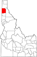
Location in the state of Idaho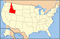
Idaho's location in the U.S.Founded December 22, 1864 Named for Kootenai tribe Seat Coeur d'Alene Largest city Coeur d'Alene Area
- Total
- Land
- Water
1,315.69 sq mi (3,408 km²)
1,245.12 sq mi (3,225 km²)
70.57 sq mi (183 km²), 5.36%Population
- (2010)
- Density
138,494
111/sq mi (45/km²)Time zone Pacific: UTC-8/-7 Website kcgov.us Kootenai County is a county located in the U.S. state of Idaho. The county was established in 1864, named after Kootenai tribe. The entire county comprises the Coeur d'Alene, Idaho Metropolitan Statistical Area. The population was 138,494 at the 2010 census.[1] The county seat and largest city is Coeur d'Alene.[2]
Directly west across the state border is the Spokane, Washington Metropolitan Statistical Area, comprising Spokane County, Washington; the combined population of the two counties was estimated at 608,074 in 2009.[3]
Contents
Geography
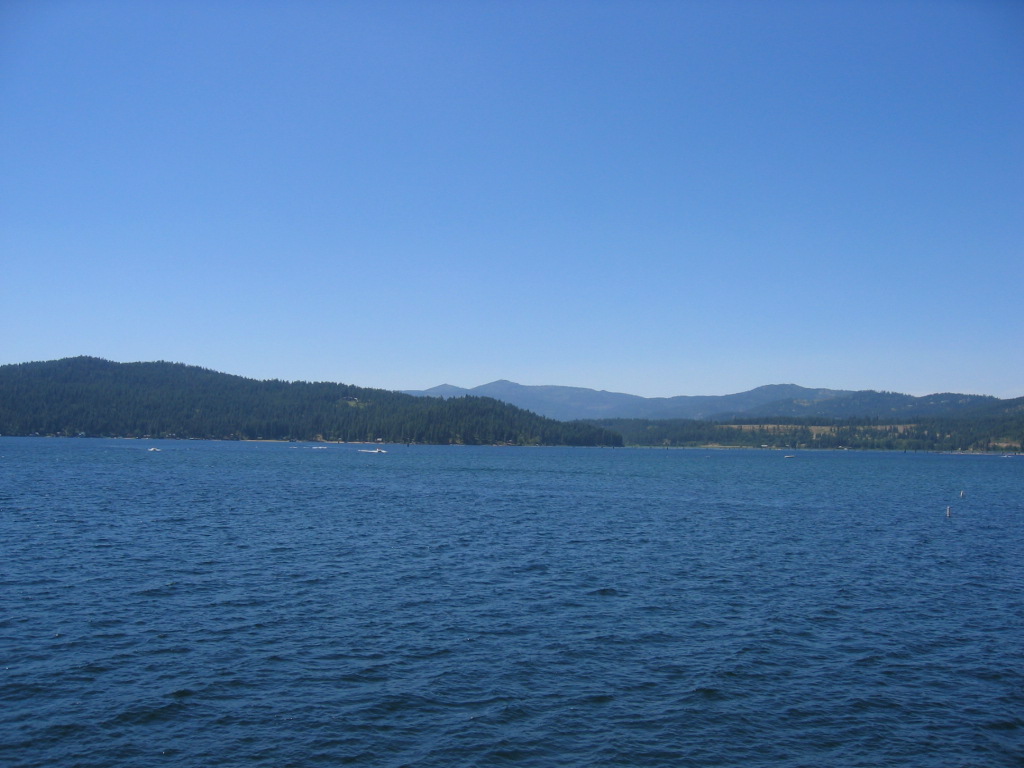
According to the 2000 census, the county has a total area of 1,315.69 square miles (3,407.6 km2), of which 1,245.12 square miles (3,224.8 km2) (or 94.64%) is land and 70.57 square miles (182.8 km2) (or 5.36%) is water.[4] The vast majority of the water area is the county's primary attraction, Lake Coeur d'Alene. Kootenai County is part of the Inland Empire in the Idaho Panhandle.
Adjacent counties
- Bonner County - north
- Shoshone County - east
- Benewah County - south
- Spokane County, Washington - west
National protected areas
- Coeur d'Alene National Forest (part)
- Kaniksu National Forest (part)
 Lake Coeur d'Alene in Kootenai County
Highways
 - Interstate 90
 - US 95
 - SH-3
 - SH-41
 - SH-53
 - SH-54
 - SH-97
History
Kootenai County was formed on December 22, 1864, from the northern section of Nez Perce County. It was named after the Kootenai, because it lies in the traditional area of settlement of the tribe.[5]
Once comprising most of the western Panhandle, the county's present boundaries were established in 1915, following the formation of Benewah County to the south.
Directly east of Kootenai County is Shoshone County and the Silver Valley, which has had a history of disputes between miners and mine owners.
Demographics
Historical populations Census Pop. %± 1890 4,108 — 1900 10,216 148.7% 1910 22,747 122.7% 1920 17,878 −21.4% 1930 19,469 8.9% 1940 22,283 14.5% 1950 24,947 12.0% 1960 29,556 18.5% 1970 35,332 19.5% 1980 59,770 69.2% 1990 69,795 16.8% 2000 108,685 55.7% 2010 138,494 27.4% sources:[1][6] As of the census[7] of 2000, there were 108,685 people, 41,308 households, and 29,659 families residing in the county. The population density was 87 people per square mile (34/km²). There were 46,607 housing units at an average density of 37 per square mile (14/km²). The racial makeup of the county was 95.84% White, 0.17% Black or African American, 1.23% Native American, 0.50% Asian, 0.07% Pacific Islander, 0.59% from other races, and 1.60% from two or more races. 2.33% of the population were Hispanic or Latino of any race. 23.2% were of German, 11.9% English, 10.9% Irish, 9.4% American and 6.1% Norwegian ancestry according to Census 2000. 96.6% spoke English and 1.7% Spanish as their first language.
There were 41,308 households out of which 34.90% had children under the age of 18 living with them, 58.60% were married couples living together, 9.20% had a female householder with no husband present, and 28.20% were non-families. 21.90% of all households were made up of individuals and 8.30% had someone living alone who was 65 years of age or older. The average household size was 2.60 and the average family size was 3.03.
In the county the population was spread out with 27.10% under the age of 18, 8.70% from 18 to 24, 28.00% from 25 to 44, 23.90% from 45 to 64, and 12.30% who were 65 years of age or older. The median age was 36 years. For every 100 females there were 98.10 males. For every 100 females age 18 and over, there were 94.90 males.
The median income for a household in the county was $37,754, and the median income for a family was $42,905. Males had a median income of $33,661 versus $22,113 for females. The per capita income for the county was $18,430. About 7.70% of families and 10.50% of the population were below the poverty line, including 12.90% of those under age 18 and 7.30% of those age 65 or over.
Communities
Cities
Unincorporated communities
See also
References
- ^ a b QuickFacts - Kootenai County, Idaho, U.S. Census Bureau, 2009-02-20. Accessed 2009-05-26.
- ^ "Find a County". National Association of Counties. http://www.naco.org/Counties/Pages/FindACounty.aspx. Retrieved 2011-06-07.
- ^ QuickFacts - Spokane County, Washington, United States Census Bureau, 2009-02-20. Accessed 2009-05-26.
- ^ "Census 2000 U.S. Gazetteer Files: Counties". United States Census. http://www.census.gov/tiger/tms/gazetteer/county2k.txt. Retrieved 2011-02-13.
- ^ Kootenai County - Idaho.gov
- ^ census.gov Idaho population by county, 1900-90 - accessed on 2009-05-25
- ^ "American FactFinder". United States Census Bureau. http://factfinder.census.gov. Retrieved 2008-01-31.
External links

Bonner County Spokane County, Washington 
Shoshone County  Kootenai County, Idaho

Benewah County Municipalities and communities of Kootenai County, Idaho Cities Athol | Coeur d'Alene | Dalton Gardens | Fernan Lake Village | Harrison | Hauser | Hayden | Hayden Lake | Huetter | Post Falls | Rathdrum | Spirit Lake | State Line | Worley

CDPs Conkling Park | Rockford Bay
Unincorporated
communitiesBayview | Cataldo‡ | Clarksville | Garwood | Lane | Medimont | North Pole
Indian reservation Footnotes ‡This populated place also has portions in an adjacent county or counties
 State of Idaho
Topics - Index
- Geography
- Government
- Delegations
- Governors
- History
- Symbols
- Images
- People
- Visitor Attractions
Society Regions Larger
citiesSmaller
citiesCounties - Ada
- Adams
- Bannock
- Bear Lake
- Benewah
- Bingham
- Blaine
- Boise
- Bonner
- Bonneville
- Boundary
- Butte
- Camas
- Canyon
- Caribou
- Cassia
- Clark
- Clearwater
- Custer
- Elmore
- Franklin
- Fremont
- Gem
- Gooding
- Idaho
- Jefferson
- Jerome
- Kootenai
- Latah
- Lemhi
- Lewis
- Lincoln
- Madison
- Minidoka
- Nez Perce
- Oneida
- Owyhee
- Payette
- Power
- Shoshone
- Teton
- Twin Falls
- Valley
- Washington
Categories:- Idaho counties
- Kootenai County, Idaho
- 1864 establishments


Wikimedia Foundation. 2010.