- List of counties in New York
-

There are 62 counties in the State of New York. The first twelve counties in New York were created immediately after the British takeover of the Dutch colony of New Amsterdam, although two of these counties have since been abolished. The most recent county formation in New York was in 1914, when Bronx County was created from the portions of New York City that had been annexed from Westchester County in the late 19th century and added to New York County.[1] New York's counties are named for a variety of Native American words, British provinces, counties, cities, and royalty, early American statesmen and military, and New York State politicians.[2]
Five of New York's counties are coterminous with the five boroughs of New York City and do not have functioning county governments, except for a few borough officials. New York City is considered the county seat of these five counties: New York County (Manhattan), Kings County (Brooklyn), Bronx County (The Bronx), Richmond County (Staten Island), and Queens County (Queens). Because each borough has a separate main Post Office (and Queens has four of them), the county seats of the five boroughs are often stated in terms of those main post offices: New York (Manhattan), Brooklyn, Bronx, Staten Island, and Jamaica (Queens). However, the communities served by those main post offices are all within the city limits of New York. In contrast to other counties of New York state, the powers of the five boroughs of New York City are very limited, and in nearly all respects are subordinate to the city's.[3]
The FIPS county code is the five-digit Federal Information Processing Standard (FIPS) code which uniquely identifies counties and county equivalents in the United States. The three-digit number is unique to each individual county within a state, but to be unique within the entire United States, it must be prefixed by the state code. This means that, for example, while Albany County, New York, is 001, Addison County, Vermont, and Alachua County, Florida, are also 001. To uniquely identify Albany County, New York, one must use the state code of 36 plus the county code of 001; therefore, the unique nationwide identifier for Albany County, New York, is 36001. The links in the column FIPS County Code are to the Census Bureau Info page for that county.[4]
Contents
Alphabetical list
County FIPS Code
[4]County Seat
[5]Created
[5]Formed from
[1]Named for
[2]Population
[5]Area
[5]Map
Albany County 001 Albany 1683 One of 12 original counties created in the New York colony James II of England (James VII of Scotland) (1633–1701), who was Duke of York (English title) and Duke of Albany (Scottish title) before becoming King of England, Ireland, and Scotland. 304,204 533 sq mi
(1,380 km2)
Allegany County 003 Belmont 1806 Genesee County A variant spelling of the Allegheny River 48,946 1,034 sq mi
(2,678 km2)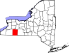
Bronx County 005 New York City (coextensive with
The Bronx)1914[6] New York County Jonas Bronck (1600?–1643), an early settler of the Dutch colony of New Amsterdam 1,385,108 57.43 sq mi
(149 km2)
Broome County 007 Binghamton 1806 Tioga County John Broome (1738–1810), fourth Lieutenant Governor of New York 200,600 715 sq mi
(1,852 km2)
Cattaraugus County 009 Little Valley 1808 Genesee County A Seneca word meaning "bad smelling banks", referring to the odor of natural gas which leaked from local rock formations 80,317 1,310 sq mi
(3,393 km2)
Cayuga County 011 Auburn 1799 Onondaga County The Cayuga tribe of Native Americans 80,026 864 sq mi
(2,238 km2)
Chautauqua County 013 Mayville 1808 Genesee County A Seneca word of uncertain meaning 134,905 1,500 sq mi
(3,885 km2)
Chemung County 015 Elmira 1836 Tioga County A Lenape word meaning "big horn", which was the name of a local Native American village 88,830 410.81 sq mi
(1,064 km2)
Chenango County 017 Norwich 1798 Tioga County and Herkimer County An Onondaga word meaning "large bull-thistle" 50,477 898.85 sq mi
(2,328 km2)
Clinton County 019 Plattsburgh 1788 Washington County George Clinton (1739–1812), fourth Vice President of the United States and first and third Governor of New York 82,128 1,118 sq mi
(2,896 km2)
Columbia County 021 Hudson 1786 Albany County Christopher Columbus (1451–1506), the European explorer 63,096 648 sq mi
(1,678 km2)
Cortland County 023 Cortland 1808 Onondaga County Pierre Van Cortlandt (1721–1814), first Lieutenant Governor of New York 49,336 502 sq mi
(1,300 km2)
Delaware County 025 Delhi 1797 Otsego County and Ulster County Thomas West, 3rd Baron De La Warr (1577–1618), an early colonial leader in Virginia 47,980 1,468 sq mi
(3,802 km2)
Dutchess County 027 Poughkeepsie 1683 One of 12 original counties created in the New York colony Lady Anne Hyde (1637–1671), Duchess of York and wife of King James II of England 297,488 825 sq mi
(2,137 km2)
Erie County 029 Buffalo 1821 Niagara County The Erie tribe of Native Americans 919,040 1,227 sq mi
(3,178 km2)
Essex County 031 Elizabethtown 1799 Clinton County The county of Essex in England 39,370 1,916 sq mi
(4,962 km2)
Franklin County 033 Malone 1808 Clinton County Benjamin Franklin (1706–1790), the early American printer, scientist, and statesman 51,599 1,697 sq mi
(4,395 km2)
Fulton County 035 Johnstown 1838 Montgomery County Robert Fulton (1765–1815), inventor of the steamship 55,531 533 sq mi
(1,380 km2)
Genesee County 037 Batavia 1802 Ontario County A Seneca phrase meaning "good valley" 60,079 495 sq mi
(1,282 km2)
Greene County 039 Catskill 1800 Albany County and Ulster County Nathanael Greene (1742–1786), the American Revolutionary War general 49,221 658 sq mi
(1,704 km2)
Hamilton County 041 Lake Pleasant 1816 Montgomery County Alexander Hamilton (1755–1804), the early American political theorist and first Secretary of the Treasury 4,836 1,808 sq mi
(4,683 km2)
Herkimer County 043 Herkimer 1791 Montgomery County Nicholas Herkimer (1728–1777), the American Revolutionary War general 64,519 1,458 sq mi
(3,776 km2)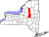
Jefferson County 045 Watertown 1805 Oneida County Thomas Jefferson (1743–1826), the early American statesman, author of the Declaration of Independence, and third President of the United States 116,229 1,857 sq mi
(4,810 km2)
Kings County 047 New York City (coextensive with
Brooklyn)1683 One of 12 original counties created in the New York colony King Charles II of England (1630–1685) 2,504,700 96.9 sq mi
(251 km2)
Lewis County 049 Lowville 1805 Oneida County Morgan Lewis (1754–1844), the fourth Governor of New York 27,087 1,290 sq mi
(3,341 km2)
Livingston County 051 Geneseo 1821 Genesee County and Ontario County Robert Livingston (1746–1813), the early American statesman and New York delegate to the Continental Congress 65,393 640 sq mi
(1,658 km2)
Madison County 053 Wampsville 1806 Chenango County James Madison (1751–1836), the early American statesman, principal author of the Constitution of the United States, and fourth President of the United States 73,442 662 sq mi
(1,715 km2)
Monroe County 055 Rochester 1821 Genesee County and Ontario County James Monroe (1758–1831), the early American statesman and fifth President of the United States 744,344 1,366 sq mi
(3,538 km2)
Montgomery County 057 Fonda 1772 Albany County Originally Tryon County after colonial governor William Tryon (1729–1788), renamed after the American Revolutionary War general Richard Montgomery (1738–1775) in 1784 50,219 410 sq mi
(1,062 km2)
Nassau County 059 Mineola 1899 Queens County William of Orange-Nassau (1650–1702), who became King William III of England 1,339,532 453 sq mi
(1,173 km2)
New York County 061 New York City (coextensive with
Manhattan)1683 One of 12 original counties created in the New York colony King James II of England (1633–1701), who was Duke of York and Albany before he ascended the throne of England, Duke of York being his English title 1,585,873 33.77 sq mi
(87 km2)
Niagara County 063 Lockport 1808 Genesee County An Iroquoian word perhaps meaning "a neck" between two bodies of water, "thunder of waters", or "bisected bottom land" 216,469 1,140 sq mi
(2,953 km2)
Oneida County 065 Utica 1798 Herkimer County The Oneida tribe of Native Americans 234,878 1,213 sq mi
(3,142 km2)
Onondaga County 067 Syracuse 1792 Herkimer County The Onondaga tribe of Native Americans 467,026 806 sq mi
(2,088 km2)
Ontario County 069 Canandaigua 1789 Montgomery County An Iroquoian word meaning "beautiful lake" 107,931 662 sq mi
(1,715 km2)
Orange County 071 Goshen 1683 One of 12 original counties created in the New York colony William of Orange-Nassau (1650–1702), who became King William III of England 372,813 839 sq mi
(2,173 km2)
Orleans County 073 Albion 1824 Genesee County The French Royal House of Orléans 42,883 817 sq mi
(2,116 km2)
Oswego County 075 Oswego 1816 Oneida County and Onondaga County The Oswego River, from an Iroquoian word meaning "the outpouring", referring to the mouth of the river 122,109 1,312 sq mi
(3,398 km2)
Otsego County 077 Cooperstown 1791 Montgomery County A Native American word meaning "place of the rock" 62,259 1,003 sq mi
(2,598 km2)
Putnam County 079 Carmel 1812 Dutchess County Israel Putnam (1718–1790), an American Revolutionary War general 99,710 246 sq mi
(637 km2)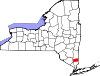
Queens County 081 New York City (coextensive with
Queens)1683 One of 12 original counties created in the New York colony Catherine of Braganza (1638–1705), Queen of England and wife of King Charles II of England 2,230,722 178.28 sq mi
(462 km2)
Rensselaer County 083 Troy 1791 Albany County In honor of the family of Kiliaen van Rensselaer (before 1596 – after 1643), the early landholder in the Dutch New Amsterdam colony 159,429 665 sq mi
(1,722 km2)
Richmond County 085 New York City (coextensive with
Staten Island)1683 One of 12 original counties created in the New York colony Charles Lennox, 1st Duke of Richmond (1672–1723), the illegitimate son of King Charles II of England 468,730 102.5 sq mi
(265 km2)
Rockland County 087 New City 1798 Orange County Early settlers' description of terrain as "rocky land" 311,687 199 sq mi
(515 km2)
St. Lawrence County 089 Canton 1802 Clinton County, Herkimer County, and Montgomery County The St Lawrence River, which forms the northern border of the county and New York State 111,944 2,821 sq mi
(7,306 km2)
Saratoga County 091 Ballston Spa 1791 Albany County A corruption of a Native American word meaning "the hill beside the river" 219,607 844 sq mi
(2,186 km2)
Schenectady County 093 Schenectady 1809 Albany County A Mohawk word meaning "on the other side of the pine lands" 154,727 210 sq mi
(544 km2)
Schoharie County 095 Schoharie 1795 Albany County and Otsego County A Mohawk word meaning "floating driftwood" 32,749 626 sq mi
(1,621 km2)
Schuyler County 097 Watkins Glen 1854 Chemung County, Steuben County, and Tompkins County Philip Schuyler (1733–1804), the American Revolutionary War general and Senator from New York 18,343 342 sq mi
(886 km2)
Seneca County 099 Ovid / Waterloo 1804 Cayuga County The Seneca tribe of Native Americans 35,251 325 sq mi
(842 km2)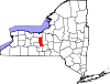
Steuben County 101 Bath 1796 Ontario County Friedrich Wilhelm von Steuben (1730–1794), the Prussian general who assisted the Continental Army during the American Revolutionary War 98,990 1,404 sq mi
(3,636 km2)
Suffolk County 103 Riverhead 1683 One of 12 original counties created in the New York colony The county of Suffolk in England 1,493,350 2,373 sq mi
(6,146 km2)
Sullivan County 105 Monticello 1809 Ulster County John Sullivan (1740–1795), an American Revolutionary War general 77,547 997 sq mi
(2,582 km2)
Tioga County 107 Owego 1791 Montgomery County A Native American word meaning "at the forks", describing a meeting place 51,125 523 sq mi
(1,355 km2)
Tompkins County 109 Ithaca 1817 Cayuga County and Seneca County Daniel D. Tompkins (1774–1825), the 6th Vice President of the United States 101,564 476 sq mi
(1,233 km2)
Ulster County 111 Kingston 1683 One of 12 original counties created in the New York colony The Irish province of Ulster, then an earldom of the Duke of York, later King James II of England 182,493 1,161 sq mi
(3,007 km2)
Warren County 113 Queensbury 1813 Washington County Joseph Warren (1741–1775), the early American patriot and American Revolutionary War general 65,707 870 sq mi
(2,253 km2)
Washington County 115 Fort Edward 1772 Albany County Originally Charlotte County, renamed in 1784 after George Washington (1732–1799), the American Revolutionary War general and first President of the United States 63,216 846 sq mi
(2,191 km2)
Wayne County 117 Lyons 1823 Ontario County and Seneca County General Anthony Wayne (1745–1796), the American Revolutionary War general 93,772 1,384 sq mi
(3,585 km2)
Westchester County 119 White Plains 1683 One of 12 original counties created in the New York colony The city of Chester in England 949,113 500 sq mi
(1,295 km2)
Wyoming County 121 Warsaw 1841 Genesee County A modification of a word from the Lenape language meaning "broad bottom lands" 42,155 596 sq mi
(1,544 km2)
Yates County 123 Penn Yan 1823 Ontario County and Steuben County Joseph C. Yates (1768–1837), eighth Governor of New York 25,348 376 sq mi
(974 km2)
Defunct counties
County Created
[1]Abolished
[1]Fate[1] Charlotte County 1772 1784 Partitioned and renamed as Washington County Cornwall County 1665 1686 Transferred to the part of Massachusetts that later became the state of Maine and partitioned; one of the 12 original counties created in the New York colony Cumberland County 1766 1777 Transferred to Vermont and partitioned Dukes County 1683 1692 Transferred to Massachusetts; one of 12 original counties created in the New York colony Gloucester County 1770 1777 Transferred to Vermont and partitioned Tryon County 1772 1784 Renamed as Montgomery County Proposed new counties
County Note Adirondack County Would hypothetically consist of portions of northern Essex County and southern Franklin County[7] Peconic County Would hypothetically consist of the five easternmost towns in Suffolk County on Long Island.[8] Clickable map
 QueensKingsRichmondNew YorkBronxSaint Lawrence
See also
References
- ^ a b c d e "New York Formation Maps". Genealogy, Inc.. http://www.mynewyorkgenealogy.com/ny_maps/ny_cf.htm. Retrieved 2008-01-20.
- ^ a b Beatty, Michael (2001). County Name Origins of the United States. McFarland Press. ISBN 0786410256.
- ^ Benjamin, Gerald, Richard P. Nathan (1990). Regionalism and realism: A Study of Government in the New York Metropolitan Area. Brookings Institute. pp. 59.
- ^ a b "EPA County FIPS Code Listing". US Environmental Protection Agency. http://www.epa.gov/enviro/html/codes/ny.html. Retrieved 2007-07-24.
- ^ a b c d "Find A County". National Association of Counties. http://www.naco.org/Counties/Pages/NACo_FindACounty.aspx. Retrieved August 9, 2010.
- ^ Legislation splitting off Bronx County from New York County was enacted in 1912 with an effective date of January 1, 1914. Prior to 1874 the entire area had been part of Westchester County. See McCarthy, Thomas C. "A 5-Borough Centennial Preface for the Katharine Bement Davis Mini-History". New York City Department of Corrections. http://www.correctionhistory.org/html/chronicl/kbd/kbd_brnx.html. Retrieved 2008-01-25.
- ^ Lynch, Mike (2007-10-30). "North Elba Supervisor Candidate Debate". Plattsburgh Press Republican. http://www.pressrepublican.com/0100_news/local_story_303233100.html. Retrieved 2008-01-20.
- ^ Healy, Patrick (2004-02-11). "Growth Pains and Clout Heading East in Suffolk". The New York Times. http://query.nytimes.com/gst/fullpage.html?res=9C0CE7DF123AF932A25751C0A9629C8B63. Retrieved 2008-01-20.
Administrative divisions of New York Primary divisions CountiesSecondary divisions Other divisions List of U.S. counties and county-equivalents
by political division (state / federal district)- Alabama
- Alaska
- Arizona
- Arkansas
- California
- Colorado
- Connecticut
- Delaware
- District of Columbia
- Florida
- Georgia
- Hawaii
- Idaho
- Illinois
- Indiana
- Iowa
- Kansas
- Kentucky
- Louisiana
- Maine
- Maryland
- Massachusetts
- Michigan
- Minnesota
- Mississippi
- Missouri
- Montana
- Nebraska
- Nevada
- New Hampshire
- New Jersey
- New Mexico
- New York
- North Carolina
- North Dakota
- Ohio
- Oklahoma
- Oregon
- Pennsylvania
- Rhode Island
- South Carolina
- South Dakota
- Tennessee
- Texas
- Utah
- Vermont
- Virginia
- Washington
- West Virginia
- Wisconsin
- Wyoming
Categories:- New York counties
- Lists of U.S. counties by state
- New York-related lists


Wikimedia Foundation. 2010.