- Staten Island
Infobox Settlement
name = Staten Island
official_name = Richmond County
other_name =
native_name =
nickname =
settlement_type =Borough of New York City
total_type =
motto =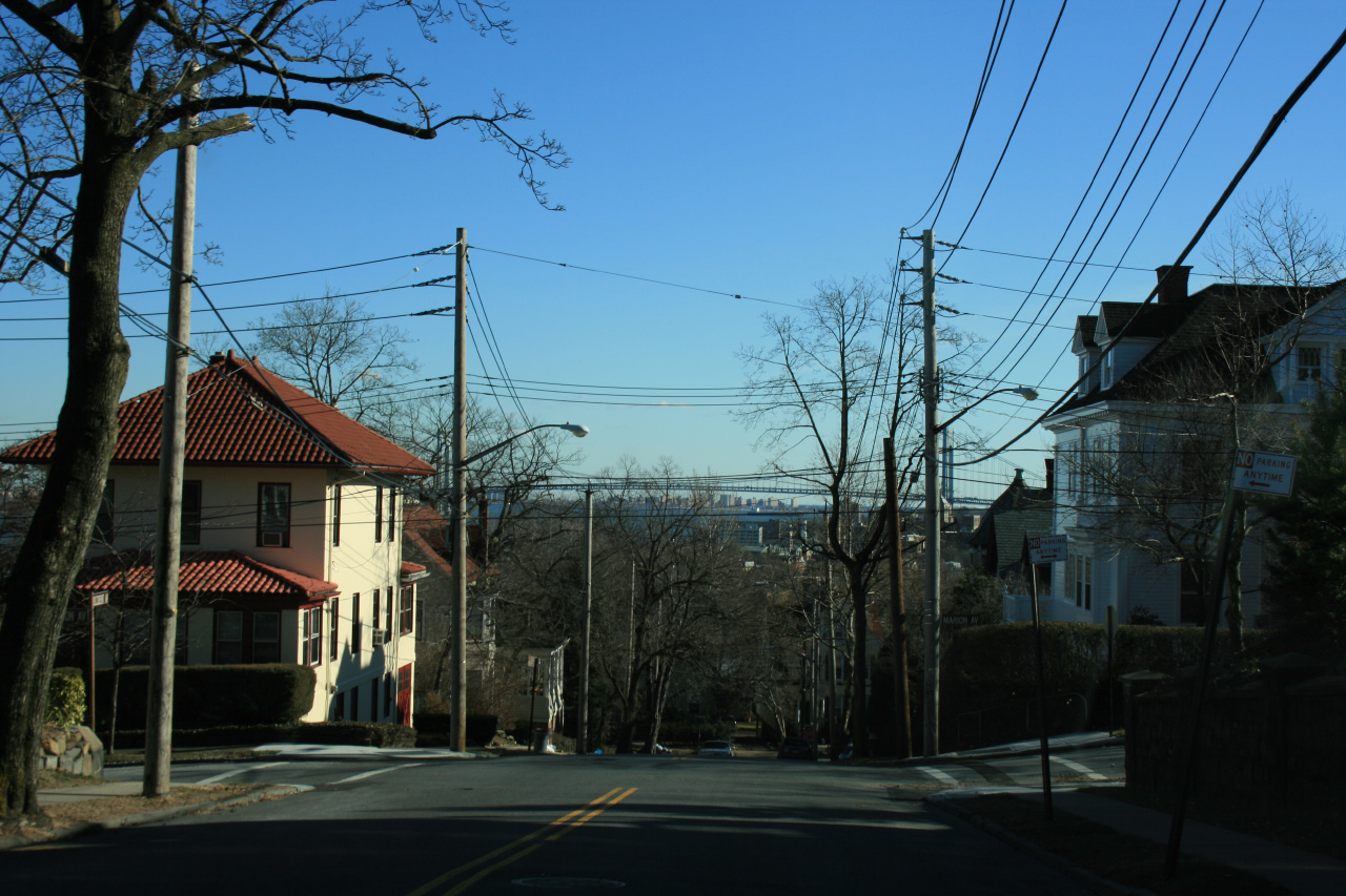
imagesize =
image_caption = Staten Island streets with views of theVerrazano-Narrows Bridge andBrooklyn in the distance.
flag_size =
image_
seal_size =
image_shield =
shield_size =
image_blank_emblem =
blank_emblem_type =
blank_emblem_size =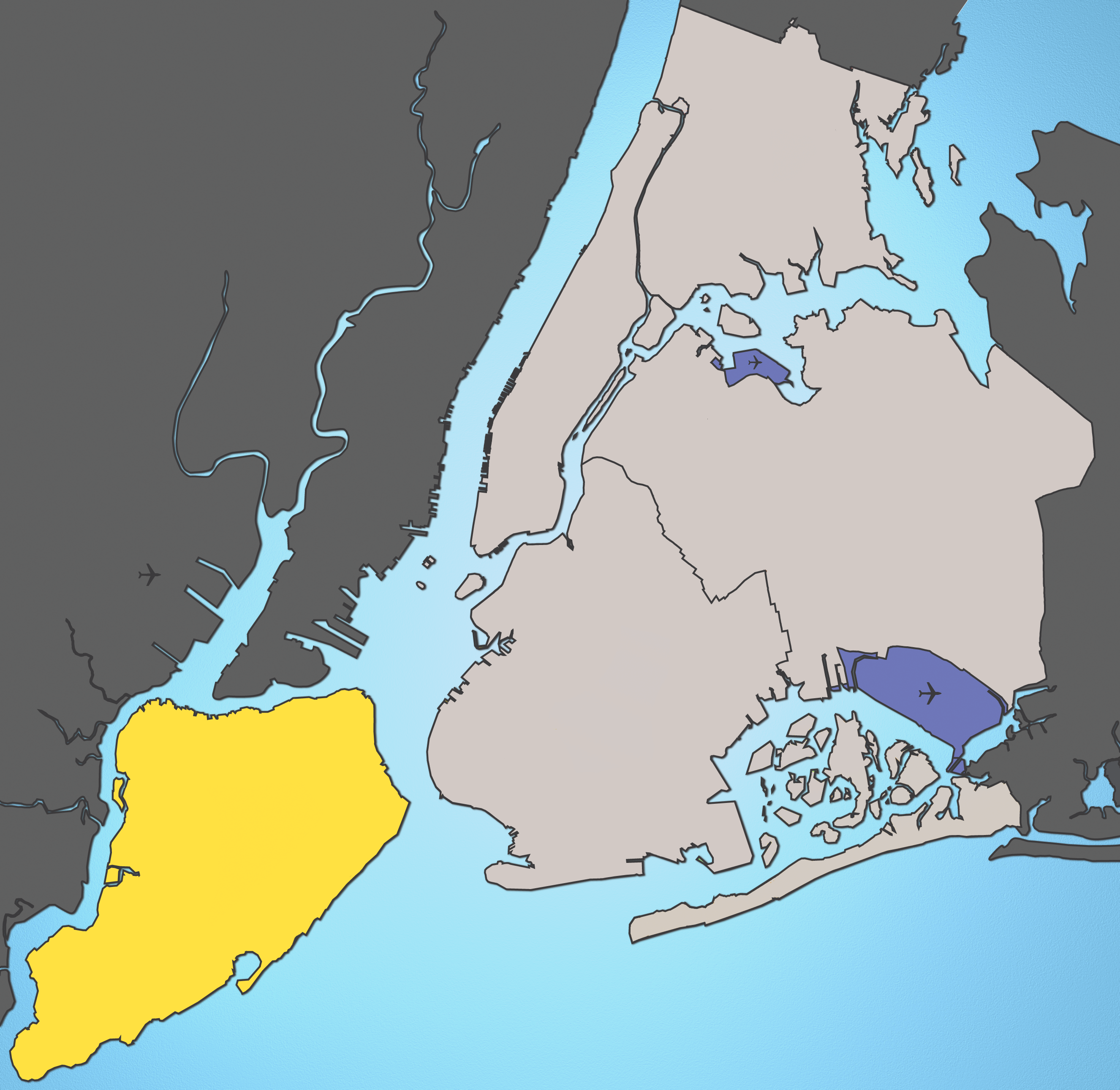
mapsize =
map_caption = Location of Staten Island shown in yellow.
pushpin_
pushpin_label_position =
pushpin_map_caption =
pushpin_mapsize =
subdivision_type = Country
subdivision_name = United States
subdivision_type1 = State
subdivision_name1 =New York
subdivision_type2 = County
subdivision_name2 = Richmond
subdivision_type3 = City
subdivision_name3 =New York City
seat_type =
seat =
parts_type =
parts_style =
parts =
p1 =
p2 =
government_footnotes =
government_type =Borough (New York City)
leader_title =Borough Pres.
leader_name =James Molinaro
leader_title1 =
leader_name1 =
established_title = Settled
established_date = 1661
area_magnitude =
unit_pref =
area_footnotes =
area_total_sq_mi =102.50
area_land_sq_mi =58.48
area_water_sq_mi =44.02
area_water_percent =
elevation_footnotes =
elevation_m =
elevation_ft =
elevation_max_m =
elevation_max_ft =
elevation_min_m =
elevation_min_ft =
population_as_of =
population_footnotes =
population_note =
population_total =477377
population_density_sq_mi =7587.9
timezone =Eastern Standard Time (North America)
utc_offset = -5
timezone_DST =Eastern Daylight Time (North America)
utc_offset_DST = -4
latd=40 |latm=34 |lats=34.61 |latNS=N
longd=74 |longm=8 |longs=41.42 |longEW=W
postal_code_type =
postal_code =
area_code = 718 &
347 (overlaid)
website = [http://www.statenislandusa.com/ Official Website of the Staten Island Borough President]
footnotes = Staten Island (pronEng|ˌstætənˈaɪlənd) is a borough ofNew York City situated primarily on the island of the same name. It is separated fromNew Jersey by theArthur Kill and theKill Van Kull , and from the rest of New York byNew York Bay . With a population of about 477,377, Staten Island is the least populated of the five boroughs but is the third largest in area at convert|59|sqmi|km2|0|abbr=on.The Borough of Staten Island is with Richmond County, the southernmost county in the state of
New York . Until 1975, the borough was officially named the Borough of Richmond. [ [http://www.nypl.org/branch/staten/history/timeline5.html New York Public Library Staten Island Timeline] , accessedJanuary 16 ,2006 ] Staten Island has been sometimes called "the forgotten borough" by inhabitants who feel neglected by the city government. [Brown, Chip. [http://query.nytimes.com/gst/fullpage.html?res=9901E7DC1230F933A05752C0A962958260&scp=6&sq=%22the+forgotten+borough%22+government "Escape From New York"] , "The New York Times ",January 30 ,1994 . AccessedJanuary 14 ,2008 . "Given their status as residents of "the forgotten borough" – the sorry Cinderella sister in New York's dysfunctional family – maybe the giddiest aspect of all was the attention." "See also" Buckley, Cara. [http://www.nytimes.com/2007/10/07/nyregion/thecity/07hips.html?_r=1&scp=1&sq=%22the+forgotten+borough%22&oref=slogin "Bohemia by the Bay"] , "The New York Times ",October 7 ,2007 . AccessedJanuary 14 ,2008 . "Even as New York’s hip young things invade and colonize neighborhoods near, far and out of state, Staten Island has stayed stubbornly uncool. It remains the forgotten borough."]Staten Island is overall the most suburban of the five boroughs of New York City. The North Shore, especially the neighborhoods of St. George, Tompkinsville, Park Hill, and Stapleton, is the most urban part of the island; it contains the officially designated St. George Historic District and The St. Paul’s Avenue-Stapleton Heights Historic District, which feature large Victorian homes. The South Shore has more suburban-style residential neighborhoods and is home to the two and one-half mile long F.D.R. Boardwalk, the fourth longest in the world. Historically, the central and southern sections of the island were once dominated by dairy and poultry farms, almost all of which disappeared in the 20th century.
The borough is accessible to
Brooklyn via theVerrazano-Narrows Bridge and to New Jersey via theGoethals Bridge ,Outerbridge Crossing , andBayonne Bridge . Staten Island has Metropolitan Transportation Authority (MTA) bus service and an MTA rapid transit line, theStaten Island Railway , which runs from the ferry terminal at St. George toTottenville . The freeStaten Island Ferry connects the borough toManhattan and is a popular tourist attraction, providing views of theStatue of Liberty ,Ellis Island and lower Manhattan.History
Geographically, Staten Island was formed in the wake of the last
ice age . In the latePleistocene between 20,000 and 14,000 years ago, theice sheet that covered northeastern North America reached as far south as present day New York City, to a depth of approximately the same height as theEmpire State Building . At one point, during its maximum reach, the ice sheet precisely ended at the center of present day Staten Island, forming a terminal moraine on the existing diabase sill. The central moraine of the island is sometimes called theSerpentine ridge because it contains large amounts of that particular mineral..
As in much of North America, human habitation appeared in the island fairly rapidly after the retreat of the ice sheet.
Archaeologist s have recovered tool evidence ofClovis culture activity dating from approximately 14,000 years ago. The island was probably abandoned later, possibly because of theextinction of largemammal s on the island. Evidence of the first permanent American Indian settlements and agriculture are thought to date from about 5,000 years ago (Jackson, 1995), although early archaic habitation evidence has been found in multiple locations on the island (Ritchie 1963)In the 16th century, the island was part of a larger area known as
Lenapehoking that was inhabited by theLenape , an American Indian people who speak their own languages within theAlgonquian languages group, and who were later named the "Delaware" by Europeans. [The Lenape are "not" "Algonquian Indians". As the Algonquian languages article explains, this refers to a linguistic category, not an ethnicity.] The band that occupied the southern part of the island was called the Raritan. To the Lenape, the island was known as "Aquehonga Manacknong" and "Eghquaons" (Jackson, 1995). The island was laced with foot trails, one of which followed the south side of the ridge near the course of present day Richmond Road and Amboy Road. The Lenape did not live in fixed encampments, but moved seasonally, usingslash and burn agriculture. The staples of their diet includedshellfish , including theoyster s that are native to bothUpper New York Bay andLower New York Bay .taten Island
The first recorded
Europe an contact with the island was in 1524 byGiovanni da Verrazzano , who sailed throughThe Narrows . In 1609,Henry Hudson established Dutch trade in the area and named the island "Staaten Eylandt" after the "Staten-Generaal", the Dutch parliament.Although the first Dutch settlement of the
New Netherland s colony was made on nearbyManhattan in 1620, "Staaten Eylandt" remained uncolonized by the Dutch for many decades. From 1639 to 1655, the Dutch made three separate attempts to establish a permanent settlement on the island, but each time the settlement was destroyed in the conflicts between the Dutch and the local tribes.In 1661, the first permanent Dutch settlement was established at "Oude Dorp" (Dutch for "Old Village"),cite book |title=The Epic of New York City |author=Ellis, Edward Robb |publisher=Old Town Books |year=1966 |pages=p. 55] just south of
the Narrows near South Beach, by a small group of Dutch, Walloon, andHuguenot families.Richmond County
At the end of the
Second Anglo-Dutch War in 1667, the Dutch cededNew Netherlands colony toEngland in the Treaty of Breda, and what was now anglicized as "Staten Island" became part of the new English colony of New York.In 1670, the Native Americans ceded all claims to Staten Island to the English in a deed to Gov.
Francis Lovelace . In 1671, in order to encourage an expansion of the Dutch settlements, the English resurveyed Oude Dorp (which became known as "Old Town") and expanded the lots along the shore to the south. These lots were settled primarily by Dutch and became known as "Nieuwe Dorp" (meaning "New Village"), which later became anglicized asNew Dorp .Captain Christopher Billopp, after years of distinguished service in the Royal Navy, came to America in 1674 in charge of a company of infantry. The following year, he settled on Staten Island, where he was granted a patent for convert|932|acre|km2|1 of land. According to one version of an oft-repeated but inaccurate myth, Capt. Billopp's seamanship secured Staten Island to New York, rather than to New Jersey: the Island would belong to New York if the captain could circumnavigate it in one day, which he did, according to the myth. Mayor
Michael Bloomberg perpetuated the myth by referring to it at a news conference in Brooklyn onFebruary 20 ,2007 . [Citation
last=Chan
first=Sewell
title=That Old Tale About S.I.? Hold On Now
newspaper=New York Times
year=2007
date=2007-02-21 ]In 1683, the colony of New York was divided into ten counties. As part of this process, Staten Island, as well as several minor neighboring islands, were designated as "Richmond County". The name derives from the title of an illegitimate son of King Charles II.
In 1687 and 1688, the English divided the island into four administrative divisions based on natural features: the 5100 acre (21 km²) manorial estate of colonial governor
Thomas Dongan in the central hills known as the "Lordship or Manner of Cassiltown," along with the North, South, and West divisions. These divisions would later evolve into the four townships Castleton, Northfield, Southfield, and Westfield. In 1698, the population was 727.cite book|last=Greene and Harrington|first=|title=American Population Before the Federal Census of 1790|publisher=|location=New York|year=1932|isbn=|pages=,as cited in: cite book|last=Rosenwaike|first=Ira|title=Population History of New York City|publisher=Syracuse University Press|location=Syracuse, N.Y.|year=1972|isbn=0815621558|pages=p.12]The government granted land patents in rectangular blocks of eighty acres (320,000 m²), with the most desirable lands along the coastline and inland waterways. By 1708, the entire island had been divided up in this fashion, creating 166 small farms and two large manorial estates, the Dongan estate and a 1600 acre (6.5 km²) parcel on the southwestern tip of the island belonging to Christopher Billop (Jackson, 1995).
In 1729, a county seat was established at the village of Richmond Town, located at the headwaters of the
Fresh Kills near the center of the island. By 1771, the island's population had grown to 2,847.The American Revolution and 19th century
The island played a significant role in the
American Revolutionary War . OnMarch 17 ,1776 , the British forces underWilliam Howe evacuatedBoston and sailed for Halifax, Nova Scotia. From Halifax, Howe prepared to attackNew York City . Howe used the strategic location of Staten Island as a staging ground for the attack. Howe established his headquarters in New Dorp at theRose and Crown Tavern near the junction of present New Dorp Lane and Amboy Road. It is here that the representatives of the British government reportedly received their first notification of the Declaration of Independence.The following month, in August 1776, the British forces crossed
the Narrows toBrooklyn and routed the American forces underGeorge Washington at theBattle of Long Island , resulting in the British capture of New York. Three weeks later, onSeptember 11 ,1776 , the British received a delegation of Americans consisting ofBenjamin Franklin ,Edward Rutledge , andJohn Adams at theConference House on the southwestern tip of the island (known today asTottenville ) on the former estate of Christopher Billop. The Americans refused the peace offer from the British in exchange for the withdrawal of the Declaration of Independence, however, and the conference ended without an agreement.On
August 22 ,1777 , theBattle of Staten Island occurred here between the British and several companies of the2nd Canadian Regiment fighting alongside other American companies. While the battle was inconclusive, with both sides surrendering over a hundred troops as prisoners, the Americans withdrew.British forces remained on Staten Island throughout the war. Although local sentiment was predominantly Loyalist, the islanders found the demands of supporting the troops to be onerous. Many buildings and churches were destroyed, and the military demand for resources resulted in an extensive
deforestation of the island by the end of the war. The British again used the island as a staging ground for their final evacuation ofNew York City onDecember 5 ,1783 . After the war, the largest Loyalist landowners fled toCanada and their estates were subdivided and sold.On
July 4 ,1827 , the end of slavery in New York state was celebrated at Swan Hotel, West Brighton. Rooms at the hotel were reserved months in advance as local abolitionists and prominent free blacks prepared for the festivities. Speeches, pageants, picnics, and fireworks marked the celebration, which lasted for two days.In 1860, parts of Castleton and Southfield were made into a new town, Middletown. The Village of New Brighton in the town of Castleton was incorporated in 1866, and in 1872 the Village of New Brighton annexed all the remainder of the Town of Castleton and became coterminous with the town.
Consolidation with New York City
These towns and villages were dissolved in 1898 with the consolidation of the
City of Greater New York , with Richmond as one of its five boroughs.Except for the areas along the harbor, however, the borough remained relatively undeveloped until the building of the
Verrazano-Narrows Bridge in 1964, which opened up the island to explosive suburban development by giving it direct road access to Brooklyn. The Verrazano, along with the other three major Staten Island bridges, created a new way for commuters and tourists to travel fromNew Jersey toBrooklyn ,Manhattan , and areas further east onLong Island . The network of highways running between the bridges has effectively carved up many of the borough's old neighborhoods. This road expansion was planned initially byRobert Moses .Throughout the 1980s, a movement to secede from the city steadily grew in popularity, reaching its peak during the mayoral term of
David Dinkins . In a 1993 referendum, 65% voted to secede, but implementation was blocked in the State Assembly.In the 1980s, the
United States Navy had a base on Staten Island called Naval Station New York. It was composed of two sections: a home port in Stapleton and a larger section aroundFort Wadsworth , where the Verrazano-Narrows Bridge enters the island. Originally, this base was to be the home port for thebattleship USS "Iowa" (BB-61), but an explosion in one of the ship's turrets led to the vessel's decommissioning. A number of other vessels, including thefrigate s USS Donald B. Beary FF 1085 and USS Ainsworth FF 1090 and at least onecruiser , theUSS Normandy (CG-60), were based there. The base was closed in 1994 through theBase Realignment and Closure process because of its small size and the expense of basing personnel there. A subsequent plan to use the site as a movie studio headed by actor and New York nativeDanny Aiello faltered due to money problems. It was recently announced that the property will be converted into a mixed-use waterfront neighborhood with an announced completion date of 2009.Opened as a "temporary landfill" in 1947,
Fresh Kills Landfill was a repository of trash for the city of New York. The landfill was closed in 2001, [ [http://www.nyc.gov/html/dcp/html/fkl/ada/about/1_2.html Fresh Kills: Landfill to close] ] but was briefly re-opened for the debris from Ground Zero following theSeptember 11, 2001 attacks . The Fresh Kills Landfill has been treated and cleaned up. A park larger thanCentral Park is in the works. Its creeks and wetlands have been designated a Significant Coastal Fish and Wildlife Habitat by the New York State Dept of Environmental Conservation (DEC). Fresh Kills and its tributaries are part of the largest tidal wetland ecosystem in the region. Plans for the park include a bird-nesting island, public roads, boardwalks, soccer and baseball fields, bridle paths and a 5,000-seat stadium. [ [http://nyc.gov/html/dcp/html/fkl/fkl3.shtml Fresh Kills - Department of City Planning ] ] Today, freshwater and tidal wetlands, fields, birch thickets and a coastal oak maritime forest, as well as areas dominated by non-native plant species, are all within the boundaries of Fresh Kills. Already, many of the landscapes of Fresh Kills possess a stark beauty, with 360 degree, wide horizon views from the hills, over convert|300|acre|km2 of salt marsh and a winding network of creeks.Geography
Infobox Islands
name = Staten
image caption =
image size =
locator
Location map|New York|lat=40.580630|long=-74.152500
map_custom = yes
native name =
native name link =
nickname =
location =New York Bay
coordinates = coord|40.580630|N|74.152500|W|display=inline
archipelago =
total islands =
major islands =
area = convert|58.48|sqmi|km2
length =
width =
highest mount =Todt Hill
elevation = convert|410|ft|m
country = United States
country admin divisions title = State
country admin divisions = flag|New York
country admin divisions title 1 = County
country admin divisions 1 = Richmond
country admin divisions title 2 = City
country admin divisions 2 =New York City
country largest city =
country largest city population =
population = 477,377
population as of = 2000
density = 8163.08
ethnic groups = 77.60% White, 9.67% Black, 0.25% Native American, 5.65% Asian, 0.04% Pacific Islander, 4.14% from other races, and 2.65% from two or more races. Hispanic or Latino of any race is 12.07% of the population
additional info =According to the
United States Census Bureau , the borough-county has a total area of 265.5 km² (102.5 sq mi). Land comprises 151.5 km² (58.5 sq mi) and water 114.0 km² (44.0 sq mi) of it (42.95%).Staten Island is separated from
Long Island bythe Narrows and from mainlandNew Jersey by theArthur Kill and theKill Van Kull .In addition to the main island, the borough and county also include several small uninhabited islands:
*The Isle of Meadows (at the mouth of
Fresh Kills )
*Prall's Island (in theArthur Kill )
*Shooters Island (inNewark Bay ; part of it belongs toNew Jersey )
*Swinburne Island (inLower New York Bay )
*Hoffman Island (in Lower New York Bay)The highest point on the island, the summit of
Todt Hill , elevation 410 ft (125 m), is also the highest point in the five boroughs, as well as the highest point on theAtlantic Coastal Plain south ofGreat Blue Hill inMassachusetts and the highest point on the coast proper south ofMaine 'sMount Desert Island .In the late 1960s the island was the site of important battles of open-space preservation, resulting in the largest area of parkland in New York City and an extensive Greenbelt that laces the island with woodland trails.
Staten Island is the only borough in New York City that does not share a land border with another borough (Marble Hill in Manhattan is contiguous with the Bronx).
Adjacent counties
*
Hudson County, New Jersey - north
*Union County, New Jersey - west
*Middlesex County, New Jersey - west
*Kings County, New York - northeast
*Monmouth County, New Jersey - south
*Queens County, New York - northeastParks
Some of the island's open space and historic areas were incorporated in 1972 into
Gateway National Recreation Area , part of theNational Park System . The Staten Island Unit of Gateway NRA is joined by theJamaica Bay Unit in Brooklyn and Queens and the Sandy Hook Unit in New Jersey. The Staten Island Unit comprises Great Kills Park, Miller Field,Fort Wadsworth ,Hoffman Island , andSwinburne Island .Clay Pit Ponds is a convert|250|acre|km2|sing=on State Park Reserve with a diverse landscape. Streams, fields, woodlands, and wetlands harbor a wide array of plants and animals. [http://www.si-web.com/Recreation/ClayPitPond.html]
Clove Lakes Park, a convert|191|acre|km2|sing=on expanse, contains a vast meadow, four lakes connected by streams, rowboating and freshwater fishing, as well as an outdoor ice skating rink (in season). Clove Lakes also offers picnic grounds, playgrounds, a baseball field, nature trails, bridle paths, a cross-country course, and a restaurant. [http://www.si-web.com/Recreation/CloveLakes.html]
South Beach is a sunbathing beach with a scenic view of the Atlantic Ocean and the Lower New York Bay. The F.D.R. Boardwalk along South Beach is two and one-half miles long, which is the fourth largest in the world. Visitors enjoy strolling and bicycling throughout the year. From October to May, fishing is also permitted. [http://www.si-web.com/Recreation/SouthBeach.html]
Great Kills Park offers swimming at the beach, fishing off the shore, baseball and football fields are available, a jogging trail and a bicycle trail. Fishing and boating are very popular throughout the season. [http://www.si-web.com/Recreation/GreatKills.html]
Latourette Park & Golf Course is located in Staten Island's Greenbelt. This green park feature's an 18-hole golf course built upon convert|125|acre|km2 of land with convert|455|acre|km2 of woodlands. When in season, ski and sleigh hills are available. [http://www.si-web.com/Recreation/Latourette.html]
Silver Lake Park is a convert|107|acre|km2|sing=on recreational area where the public may enjoy an 18-hole golf course, tennis courts, lockers, showers, a lounge and restaurant, and a clubhouse. There is also a vast green expanse which overlooks a picturesque water reservoir. [http://www.si-web.com/Recreation/SilverLake.html]
The South Shore Golf Course is a 18-hole golf course offers full accommodations supporting sportsmen, sportswomen, and anyone else who likes to watch the sport. Accommodations include a restaurant, a lounge, showers, lockers, and parking. [http://www.si-web.com/Recreation/SouthShore.html]
Tottenville Beach is located on the very southern tip of Staten Island. Nearby is The Conference House, a National Landmark remembered for its historical peace conference between the Continental Congress and Lord Howe. [http://www.si-web.com/Recreation/Tottenville.html]
William T. Davis Wildlife Refuge is a convert|260|acre|km2|sing=on sanctuary, this refuge is located within the Greenbelt of Staten Island, which is a vast convert|2500|acre|km2|sing=on parkland that includes two adventurous hiking trails called the Blue Trail and the White Trail. The park is a preserver of many varieties and species of animal and plant wildlife. [http://www.si-web.com/Recreation/Wildlife.html]
Wolfe's Pond Beach & Park is a convert|170|acre|km2|sing=on wooded parkland, with 20 acres set aside for swimming, rowboating, and daytime freshwater fishing. Salt water fishing is permitted from October to May Facilities in this park include picnic grounds, outdoor fireplaces, and a model yacht pond. [http://www.si-web.com/Recreation/WolfesPond.html]
Transportation
, at approximately a 30 minute ride and free of toll. The 55 year old St. George ferry terminal recently underwent a $130 million dollar renovation and now features floor-to-ceiling glass for panoramic views of the harbor and incoming ferries.
Staten Island is connected to
Brooklyn via theVerrazano-Narrows Bridge usingI-278 , theStaten Island Expressway . Once in Brooklyn,I-278 becomes theGowanus Expressway and then theBrooklyn Queens Expressway , providing access toManhattan through various tunnels and bridges.Staten Island is connected to New Jersey via three vehicular bridges and one railroad bridge. The
Outerbridge Crossing toPerth Amboy, New Jersey is at the southern end of Route 440 and theBayonne Bridge toBayonne, New Jersey is at the northern end of Route 440, which continues intoJersey City, New Jersey . From theNew Jersey Turnpike , theGoethals Bridge usingI-278 connects to the Staten Island Expressway. The Arthur Kill Vertical Lift Railroad Bridge carries freight between the northwest part of the island andElizabeth, New Jersey .The
Staten Island Railway traverses the island from its northeastern tip to its southwestern tip. Staten Island is the only borough not serviced by theNew York City Subway . As such, express bus service is provided by NYC Transit throughout Staten Island to lower and midtownManhattan .Government and politics
Since New York City's consolidation in 1898, Staten Island has been governed by the New York City Charter that provides for a "strong" mayor-council system. The centralized New York City government is responsible for public education, correctional institutions, libraries, public safety, recreational facilities, sanitation, water supply, and welfare services on Staten Island.
The office of
Borough President was created in the consolidation of 1898 to balance centralization with local authority. Each borough president had a powerful administrative role derived from having a vote on theNew York City Board of Estimate , which was responsible for creating and approving the city's budget and proposals for land use. In 1989 theSupreme Court of the United States declared the Board of Estimate unconstitutional on the grounds that Brooklyn, the most populous borough, had no greater effective representation on the Board than Staten Island, the least populous borough, a violation of the Fourteenth Amendment'sEqual Protection Clause pursuant to the high court's 1964 "one man, one vote" decision. [ [http://www.law.cornell.edu/supct/html/historics/USSC_CR_0489_0688_ZS.html Cornell Law School Supreme Court Collection: Board of Estimate of City of New York v. Morris] , accessedJune 12 ,2006 ]Since 1990 the Borough President has acted as an advocate for the borough at the mayoral agencies, the City Council, the New York state government, and corporations. Staten Island's Borough President is
James Molinaro , a member of the Conservative Party elected in 2001 and reelected in 2005 with the endorsement of the Republican Party. Molinaro is the only Republican-supported borough president in New York City.Staten Island's politics differ considerably from New York City's other boroughs. Although in 2005 44.7% of the borough's registered voters were registered Democrats and 30.6% were registered Republicans, the Republican Party holds a small majority of local public offices. Staten Island is the base of New York City's Republican Party in citywide elections. In the 2001 mayoral election, borough voters chose Republican
Michael Bloomberg , with 75.87% of the vote, over Democrat Mark Green, with 21.15% of the vote. Since Green narrowly lost the election citywide, Staten Island provided the margin of Bloomberg's victory. The main political divide in the borough is demarcated by the Staten Island Expressway; areas north of the Expressway tend to be more liberal while the south tends to be more conservative. Local party platforms center on affordable housing, education and law and order. Two out of Staten Island's threeNew York City Council members are Republicans.In national elections Staten Island is not the Republican stronghold it is in local elections, but it is also not the a Democratic stronghold the rest of New York City is. The borough is a Republican-leaning swing county, though like the New York suburbs in Long Island and Westchester County it has become increasingly Democratic since the 1990s.
Each of the city's five counties (coterminous with each borough) have its own criminal court system and
District Attorney , the chief public prosecutor who is directly elected by popular vote. Daniel Donovan, a Republican, has been the District Attorney of Richmond County since 2004. Staten Island has three City Council members, two Republicans and one Democrat, the smallest number among the five boroughs. It also has three administrative districts, each served by a local Community Board. Community Boards are representative bodies that field complaints and serve as advocates for local residents.Staten Island has voted for a Democratic presidential nominee only three times since 1952: in 1964, 1996, and 2000. In the 2004 presidential election RepublicanGeorge W. Bush received 57% of the vote in Staten Island and DemocratJohn Kerry received 42%. By contrast, Kerry outpolled Bush in New York City's other four boroughs by a cumulative margin of 77% to 22%.Staten Island flag
The flag is on a white background in the center of which is the design of a seal in the shape of an oval. Within the seal appears the color blue to symbolize the skyline of the borough, in which two seagulls appear colored in black and white. The green outline represents the countryside of the borough with white outline denoting the residential areas of Staten Island. Below is inscribed the words "Staten Island" in gold. Below this are five wavy lines of blue to symbolize the water that surrounds the island borough on all sides. Gold fringe outlines the flag. [ [http://www.sichamber.com/reginfo.html About the Staten Island Chamber of Commerce ] ]
Demographics
As of 2006, there were 464,573 people, 256,341 households, and 214,128 families residing in the borough/county. The
population density was 2,929.6/km² (7,587.9/sq mi). There were 163,993 housing units at an average density of 1,082.7/km² (2,804.3/sq mi). The racial makeup is 77.60% White, 9.67% Black, 0.25% Native American, 5.65% Asian, 0.04% Pacific Islander, 4.14% from other races, and 2.65% from two or more races. Hispanic or Latino of any race were 12.07% of the population.As of 2000 the population represented several European ancestries: [ [http://factfinder.census.gov/servlet/QTTable?_bm=y&-geo_id=05000US36085&-qr_name=DEC_2000_SF3_U_QTP13&-ds_name=DEC_2000_SF3_U Richmond County Ancestry] ,
United States Census, 2000 . AccessedJune 23 ,2007 .]
*Italian: 37.7%
*Irish: 16.0%
*German: 6.3%
*Polish: 4.1%
*Russian: 2.8%
*English: 2.2%Staten Island (Richmond County) has a higher percentage of Italian-Americans than any other county in the United States. Since the 2000 census, a rather large Russian community has been growing on Staten Island, particularly in the Rossville, South Beach, and Great Kills area. There is also a significant Polish community mainly in the South Beach and Midland Beach area.
The vast majority of the island's African American and Hispanic residents live north of the
Staten Island Expressway , orInterstate 278 . In terms of religion, the population is largelyRoman Catholic . TheJewish community is large enough that it would be significant in most other parts of the country, but it is relatively small compared to other parts of theNew York Metropolitan Area . There is a growing presence of EgyptianCopt s, the vast majority of whom are members of the Coptic Orthodox Church. [ [http://freecopts.net/english/index.php?option=com_content&task=view&id=454&Itemid=1 Copts in Staten Island] ] [ [http://www.michaelmenasi.com/ A Coptic Orthodox Church in Great Kills, Staten Island] ]There were 156,341 households out of which 35.8% had children under the age of 18 living with them, 55.0% are married couples living together, 13.9% had a female householder with no husband present, and 27.0% were non-families. Individuals occupied 23.2% of all households, and 8.4% of households had someone living alone who was 65 years of age or older. The average household size was 2.78 and the average family size was 3.31.
The population is spread out with 25.5% under the age of 18, 8.5% from 18 to 24, 30.9% from 25 to 44, 23.4% from 45 to 64, and 11.6% who were 65 years of age or older. The median age was 36 years. For every 100 females there were 93.6 males. For every 100 females age 18 and over, there were 89.6 males.
The median income for a household is $55,039, and the median income for a family was $64,333. Males had a median income of $50,081 versus $35,914 for females. The
per capita income for the borough was $23,905. About 7.9% of families and 10.0% of the population were below thepoverty line , including 13.2% of those under age 18 and 9.9% of those age 65 or over.Culture
Local Support for the Arts
Artists and musicians have been moving to Staten Island's North Shore so they can be in close proximity to Manhattan but also have enough affordable space to live and work in. Recently The New York Times [http://www.nytimes.com/2007/10/07/nyregion/thecity/07hips.html?pagewanted=1&_r=1] [http://video.on.nytimes.com/?fr_story=104bda05ad2b8da609a03bcacd3bda17be057b43] and NY1 News [http://www.ny1.com/ny1/content/index.jsp?&aid=69203&search_result=1&stid=242] featured Staten Island has a haven for artists. Filmmakers, most of whom work independently, also play an important part on Staten Island's art scene, which has been recoginized by the local government. Conceived by the Staten Island Economic Development Corporation to introduce independent and international films to a broad and diverse audience, the Staten Island Film Festival [http://www.sifilmfestival.org] (SIFF) held it's first 4-day festival in 2006.
Museums
Snug Harbor Cultural Center ,TheAlice Austen House Museum,TheConference House ,The Garibaldi-Meucci Museum,Jacques Marchais Museum of Tibetan Art , [http://www.noblemaritime.org/ The Noble Maritime Collection] ,Sandy Ground Historical Museum,Staten Island Children's Museum ,The Staten Island Museum [http://www.statenislandmuseum.org/] and theStaten Island Botanical Garden , home of theThe New York Chinese Scholar's Garden .Staten Island has also been selected to become the future site of the National Lighthouse Museum [http://www.lighthousemuseum.org/] .
Attractions
Historic Richmond Town is New York City’s living history village and museum complex. Visitors can explore the diversity of the American experience, especially that of Staten Island and its neighboring communities, from the colonial period to the present. The village area occupies 25 acres of a convert|100|acre|km2|sing=on site with about 15 restored buildings, including homes and commercial and civic buildings, as well as a museum.The island is home to the
Staten Island Zoo , which recently opened a newly refurbished reptile exhibit. Zoo construction commenced in 1933 as part of the Federal Government’s works program on an eight-acre estate willed to New York City. It was opened onJune 10 ,1936 , the first zoo in the U. S. specifically devoted to an educational mandate. The Staten Island Zoological Society was the first zoo in the country to specifically dedicate itself to fulfilling an educational mission. The Society has remained steadfast in its concentration on this goal, which is still a vital part of the Society’s current mission. The Staten Island Zoo was also the first zoo anywhere to exhibit all the 32 varieties of rattlesnakes known to occur in the United States. In the late 1960’s the Zoo maintained the most complete rattlesnake collection in the world with 39 varieties.Theater
The newly renovated [http://www.stgeorgetheatre.com/ St. George Theatre] serves as a cultural arts center for a myriad of activities including outreach educational programs, architectural tours, television and film shoots, concerts, comedy, Broadway touring companies and small and large scale children's shows.
Media
Staten Island's local paper is the
The Staten Island Advance . They also have an affiliated website called silive.com [http://www.silive.com] .The documentary "A Walk Around Staten Island with David Hartman and Barry Lewis" premiered on
public television stationWNET onDecember 3 ,2007 , profiling Staten Island culture and history, including major attractions such as theStaten Island Ferry ,Historic Richmondtown , theConference House ,Snug Harbor Cultural Center , the Chinese Scholars Garden and many more sites. [http://www.thirteen.org/statenislnad]Film and Television
Movies filmed partially or wholly on Staten Island include "
The Godfather "; "Working Girl "; "War of the Worlds"; "Sorry, Wrong Number "; "Sisters"; "Splendor in the Grass "; "GoodFellas "; "Donnie Brasco "; "Shamus "; "School of Rock "; "Two Family House"; "He Knows You're Alone "; "Analyze This "; "Big Daddy "; "The Astronaut's Wife ";"Scent of a Woman "; "Freedomland"; "Toxic Avenger "; and "Easy Money". Also independent films "The Atomic Space Bug " (1999), "" (2002) and "A Conversation with Norman " (2005) were filmed on Staten Island and directed byJonathan M. Parisen as well as "Combat Shock " (1986) and "No Way Home" (1996) by Staten Island director Buddy Giovinazzo.Television series shot partially or wholly on Staten Island include "
The Education of Max Bickford " and "The Book of Daniel ", as well as many parts of episodes of "Law & Order " and '. The sitcom "Grounded for Life " was set on Staten Island, while the animated ', the Humanitarian Environmental Analysis Team, a.k.a. HEAT, which monitors Godzilla, has their headquarters based on Staten Island in an old ferry terminal.Music
Singer
Christina Aguilera ,David Johansen (a.k.a.Buster Poindexter ) of theNew York Dolls , andVernon Reid ofLiving Colour were all born or reside on Staten Island. Theheavy metal bandWhite Lion and thehiphop -collectiveWu-Tang Clan both formed on Staten Island, as well as the Up & Coming Hip Hop Artist AC, who recently was noted for his 2008 Music Video for his hit record "New Soul", which features samples fromYael Naim . The Israeli-French singer-songwriter's renderation was featured in the 'Macbook Air' commerical for Apple Computers.ports
*Former
New York Mets pitcher John Franco resides in the borough.
*Staten Island Yankees ,New York-Penn League baseball, Class A Minor League affiliate to theNew York Yankees
*Former members of the Staten Island Yankees who made it to the big leagues: Jason Anderson,Andy Phillips ,Melky Cabrera ,Brandon Claussen ,Wily Mo Peña ,Robinson Canó ,Chien-Ming Wang ,Brad Halsey ,John-Ford Griffin
*TheNew York Metropolitans of the American Association played baseball on Staten Island from April 1886 through 1887.Erastus Wiman , the developer of St. George, brought the team to Staten Island where they played in a stadium called the St. George Grounds, near the site of the current-day Staten Island Yankees'Richmond County Bank Ballpark and the Staten Island Ferry terminal.
*Wagner College participates inDivision I athletics.
*NBA Basketball coachP.J. Carlesimo coached the Wagner College Basketball team the "Seahawks".
* FormerNew York Giants head coachJim Lee Howell prior was head coach of Staten Island's Wagner College Football
* Staten Island formerly had a professional football team which was a member of the NFL called the Staten Island Stapes. They were based in Stapleton. Their stadium was called Thompson's Stadium which was located on the site of present Berta A. Dreyfus Intermediate School 49 and the Stapleton Houses. They faced many other teams that still exist today. Football Hall of FamerKen Strong played for the Stapes.
* New York Predators Semi Pro football team calls Staten Island its home since its inception in 1998 owned by Bill Simo [http://www.nypredators.net] plays most homes games in Alumni Stadium on the grounds of Monsignor Farrell H.S.
* There was a controversial plan by theInternational Speedway Corporation to build a speedway on the island that would hostNASCAR races by 2010. ISC abandoned the plan in 2006, citing financial concerns.
* In 1964 Staten Island's Mid Island Little League won theLittle League World Series inWilliamsport, Pennsylvania .
* The Staten Island Cricket Club, founded in 1872, is the oldest continuously operatingcricket club in the United States. [cite web |url=http://statenislandcc.org/sicc/history.htm |title=The Staten Island Cricket Club - History |accessdate=2008-06-17 |work= |date= ]Hospitals
*
Staten Island University Hospital
*Richmond University Medical Center Education
Public schools
Education in Staten Island is provided by a number of public and private institutions. Public schools in the borough are managed by the
New York City Department of Education , the largest public school system in the United States.Public middle schools include Intermediate Schools 2, 7, 24, 27, 34, 49, 51, 61, 72 and 75.
Public high schools include:
*
Curtis High School
*New Dorp High School
*Petrides High School
*Port Richmond High School
*Staten Island Technical High School
*Susan E. Wagner High School
*Tottenville High School Private schools
*
St. John Villa Academy (all-girls')
*Staten Island Academy is the only independent private (non-public, non-religious) grade school on the island and is one of the oldest in the entire country.
*Catholic high schools include St. Peter's Boys, St. Peter's Girls, Notre Dame, St. Joseph Hill, St. John Villa, Monsignor Farrell, Moore Catholic, and St. Joseph-by-the-Sea.Colleges and universities
*The
College of Staten Island is one of the six senior colleges of theCity University of New York (CUNY). The college offers both associate's and bachelor's degrees. The College of Staten Island also offers post-graduate level study from master's to doctoral level study.
*Wagner College is a coeducational private liberal arts college with an enrollment of 1,900 undergraduates and 400 graduate students. The college is affiliated with theEvangelical Lutheran Church in America .
*St. John's University has a campus on Staten Island. It is a private, coeducational Roman Catholic university.Libraries
Twelve branches of the
New York Public Library serve the borough. The Library offers free computer instruction and English classes for speakers of other languages.Notable natives and residents
Notes
References
*Kenneth T. Jackson (editor); "
The Encyclopedia of New York City "; Yale University Press; ISBN 0-300-05536-6 (1995).
*John Waldman; "Heartbeats in the Muck"; ISBN 1-55821-720-7 The Lyons Press; (2000)
* [http://www.nypl.org/branch/staten/index2.cfm?Trg=1&d1=1391 Famous Staten Islanders page at the New York Public Library site:]External links
* [http://oldstatenisland.tripod.com/history.htm History of Staten Island in the Photo]
* [http://www.sichat.com Staten Island Chat] - Staten Island Local Guide with events calendar, links section, classified ads and message forums
* [http://www.statenislandusa.com/ Staten Island] - Office of the Borough President
* [http://www.nypl.org/branch/staten/history/timeline5.html Timeline of Staten Island History] on the New York Public Library site
* [http://www.statenislandpages.com Staten Island Forum] Everything Staten Island, from News to Entertainment to Dining and More
* [http://www.prodigalborough.com The Prodigal Borough] - We took the ferry to Staten Island and decided to stay forever
* [http://www.baby-bombers.com Baby-Bombers] - Fan site for the Staten Island Yankees started to keep the players' families up to date on the season.
* [http://www.savestatenisland.com Save Staten Island] - a site dedicated to fighting the negative image Staten Island is given in the media
* [http://si-talk.com SI-Talk] - Community Message Board
* [http://www.motherjones.com/commentary/columns/2007/07/witness.html "The Child Soldiers of Staten Island"] , "Mother Jones", July/August 2007.
* [http://www.paranormal-investigations-of-staten-island.20fr.com PISI Home] - Paranormal Investigations of Staten Island Home Page
Wikimedia Foundation. 2010.