- Champlain Valley
-
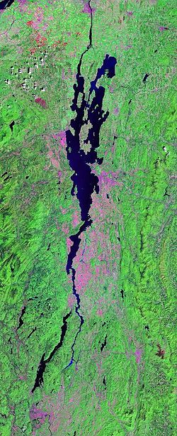
 Landsat photo of the immediate Lake Champlain region — only part of the much longer drainage basin and overall valley which reaches the Atlantic Ocean north of Nova Scotia via the St. Lawrence Seaway.
The Champlain Valley (or more technically correct, the Champlain Lake Valley) is a region of the United States around Lake Champlain in Vermont and New York extending slightly into Quebec, Canada — as part of the St. Lawrence River drainage basin drained northward by the Richelieu River into the St. Lawrence River at Sorel-Tracy, Quebec (northeast of Montreal) — but the Richelieu valley is not generally referred to as part of the Champlain.
The Champlain Lake Valley is also the most heavily populated region in Vermont, broadly stretching eastward from the lake's shore to the spine of the Green Mountains. The state's largest city, Burlington is located on the lake; the city's associated suburban communities encompass part of the central section of the valley. Beyond urbanized Chittenden County, however, the valley's landscape is primarily open pasture and row crops, making the Champlain Valley the most productive agricultural region of Vermont.
The New York portion of the Champlain Valley includes the eastern portions of Clinton County and Essex County. Most of this area is part of the Adirondack Park, offering tremendous views of the High Peaks region and many recreational opportunities in the park and along the relatively undeveloped coast line of Lake Champlain. The city of Plattsburgh is to the north and the historic village of Ticonderoga in the southern part of the region.
Geology and physiography
The Champlain Valley is among the northernmost valleys considered part of the Great Appalachian Valley reaching from Canada to Alabama.
The Champlain Valley is a physiographic section of the larger Saint Lawrence Valley province, which in turn is part of the larger Appalachian physiographic division.[1]
Lake Champlain is situated in the Champlain Valley between the Green Mountains of Vermont and the Adirondack Mountains of New York, drained northward by the Richelieu River into the St. Lawrence River at Sorel-Tracy, Quebec (northeast of Montreal) and fed by Otter Creek, the Winooski, Missisquoi, and Lamoille Rivers in Vermont, and the Ausable, Chazy, Boquet, and Saranac Rivers in New York. Lake Champlain also receives water from Lake George via the La Chute River.
References
- ^ "Physiographic divisions of the conterminous U. S.". U.S. Geological Survey. http://water.usgs.gov/GIS/metadata/usgswrd/XML/physio.xml. Retrieved 2007-12-06.
Subfields of physical geography 
 State of Vermont
Montpelier (capital) Regions Champlain Valley · Green Mountains · Mount Mansfield · Northeast Kingdom
Counties Addison · Bennington · Caledonia · Chittenden · Essex · Franklin · Grand Isle · Lamoille · Orange · Orleans · Rutland · Washington · Windham · Windsor
Metropolitan areas Burlington-South Burlington metropolitan area
Cities Barre · Burlington · Montpelier · Newport · Rutland · St. Albans · South Burlington · Vergennes · Winooski
Festivals Vermont State Fair · Green Mountain Film Festival
Topics Delegations · Constitution · Culture · Geography · Government · History · Images · People · Politics · Towns · Villages · Visitor Attractions
 State of New York
Albany (capital) · The Empire State Topics Administrative divisions · Bibliography · Congressional districts · Constitution · Demographics · Economy · Education · Elections · Geography · Government (Governor, Legislature, Court System) · History · Symbols · People · Politics · Transportation · Visitor Attractions
Regions Adirondack Mountains · Allegheny Plateau · Capital District · Catskill Mountains · Central Region (formerly Central-Leatherstocking) · Central New York · Champlain Valley · City of New York · Finger Lakes · Holland Purchase · Hudson Highlands · Hudson Valley · Long Island · Mohawk Valley · New York Metro · Niagara Frontier · North Country · Ridge and Valley · Saint Lawrence Seaway · Shawangunks · Ski country · Southern Tier · Southtowns · Tech Valley · Thousand Islands · Upstate · Western
Metro areas Albany / Schenectady / Troy · Binghamton · Buffalo / Niagara Falls · Elmira / Corning · Glens Falls · Ithaca · Jamestown · Newburgh / Middletown · New York City · Poughkeepsie · Rochester · Syracuse · Utica / Rome
Counties Albany · Allegany · Bronx · Broome · Cattaraugus · Cayuga · Chautauqua · Chemung · Chenango · Clinton · Columbia · Cortland · Delaware · Dutchess · Erie · Essex · Franklin · Fulton · Genesee · Greene · Hamilton · Herkimer · Jefferson · Kings · Lewis · Livingston · Madison · Monroe · Montgomery · Nassau · New York · Niagara · Oneida · Onondaga · Ontario · Orange · Orleans · Oswego · Otsego · Putnam · Queens · Rensselaer · Richmond · Rockland · Saint Lawrence · Saratoga · Schenectady · Schoharie · Schuyler · Seneca · Steuben · Suffolk · Sullivan · Tioga · Tompkins · Ulster · Warren · Washington · Wayne · Westchester · Wyoming · Yates
Categories:- Valleys of New York
- Valleys of Vermont
- Regions of Vermont
- Physiographic sections
- Vermont geography stubs
- New York geography stubs
- Essex County, New York geography stubs
Wikimedia Foundation. 2010.
