- Elmira, New York
Infobox Settlement |official_name = Elmira, New York
website = http://www.cityofelmira.net/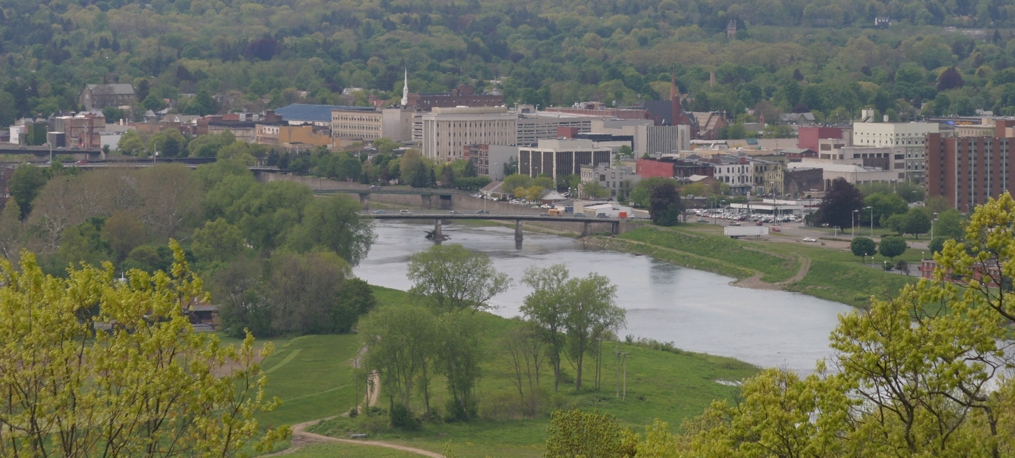

image_

map_caption = Location inChemung County in the state ofNew York
subdivision_type = Country
subdivision_type1 = State
subdivision_type2 = County
subdivision_name =United States
subdivision_name1 =New York
subdivision_name2 =Chemung County
leader_title =Mayor
leader_name = John S. Tonello (D)
established_title = Incorporated
established_date = 1864
area_magnitude = 1 E8
area_total_sq_mi = 7.58
area_land_sq_mi = 7.28
area_water_sq_mi = 0.3
area_water_percent =
area_total_km2 = 12.2
area_land_km2 = 11.72
area_water_km2 = 0.48
population_as_of = 2000
population_total = 30,940
population_metro = 90,070 (Chemung County)
population_density_sq_mi =4229.5
population_density_km2 = 1632
timezone = EST
utc_offset = -5
timezone_DST = EDT
utc_offset_DST = -5
latd = 42
latm = 5
lats = 7
latNS = N
longd = 76
longm = 48
longs = 33
longEW = W
elevation_m = 266
footnotes =Elmira is a
city in Chemung County,New York ,USA . It is the principal city of the 'Elmira, New YorkMetropolitan Statistical Area ' which encompasses Chemung County, New York. The population was 30,940 at the 2000 census. It is thecounty seat ofChemung County .The City of Elmira is located in the south-central part of the county, surrounded on three sides by the Town of Elmira. It is in the
Southern Tier of New York a short distance north of thePennsylvania state line.History
Early history
The
Sullivan Expedition of 1779 passed through the area and fought a British force at theBattle of Newtown , south of the current city. TheIroquois and the new United States made a treaty at Elmira in 1791 to settle territorial disputes in the region.The first settler in Elmira was captain
Abraham Miller of theContinental Army . He built a cabin after resigning just before the Revolutionary war.Miller's Pond and Miller Street are named after him where his house was originally built.Elmira's formation
The New York legislature established the Township of Chemung, now Chemung County, in 1788. The settlement of Newtown was soon established at the intersection of Newtown Creek and the
Chemung River . In 1792, the settlement at Newtown joined with the Wisnerburg and DeWittsburg settlements to form the village of Newtown. In 1808, the village officially changed its name to the Town of Elmira, at a town meeting held at Teal's Tavern. It's said the town was named after tavern owner Nathan Teal's young daughter, but that story has never been confirmed. In any case, the City of Elmira, also called "The Queen City", was incorporated in 1864 from part of the town of Elmira and the village of Elmira. The remaining part of the town of Elmira exists still, surrounding the city on the west, north, and east. The city and town share an intricately entwined history. According to Amos B. Carpenter's Family History book printed in 1898, Elmira is named after Major General Matthew Carpenter's daughter. This occurred according to the book in 1821 at the constitutional convention which Matthew was a delegate to.Elmira served as a transportation hub for New York's Southern Tier in the 1800s, connecting commercial centers in Rochester and Buffalo with Albany and New York City, via the canal system and railroads. The city was the southern terminus of the
Chemung Canal (completed in 1833); later, theJunction Canal was constructed to connect Elmira with Corning, facilitating transport of coal from the Pennsylvania mines via the Northern branch of the Susquehanna Canal system. Some years after, the Erie and New York Railroads were completed and criss-crossed in the midst of the city, making it a prime location for an Army training and muster point early in the Civil War.A great deal of the 30 acre Union installation, known as Camp Rathbun, fell into disuse as the Civil War progressed, and the camp's "Barracks #3" were converted into a Civil War prison camp in the summer of 1864. The camp, in use from June 6, 1864 until the fall of 1865, was dubbed "Hellmira" by its inmates. Towner's history of 1892 and maps from the period indicate the camp occupied a somewhat irregular parallelogram, running about convert|1000|ft|m|-2 west and approximately the same distance south of a location a couple of hundred feet west of Hoffman Street (Foster Avenue?) and Winsor Avenue, bordered on the south by Foster's Pond more or less, on the north bank of the Chemung River.
In the months the site was used as a camp, 12,123 Confederate soldiers were incarcerated; of these, 2,963 died during their stay from a combination of malnutrition, prolonged exposure to brutal winter weather, and disease directly attributable to the dismal sanitary conditions on Foster's Pond and lack of medical care. The camp's dead were prepared for burial and laid to rest by the sexton at
Woodlawn National Cemetery , ex-slaveJohn W. Jones . At the end of the war, each prisoner was given a loyalty oath and given a train ticket back home; the last prisoner left the camp on September 27, 1865. The camp was closed, demolished and converted to farm land. Woodlawn cemetery, about convert|2|mi|km|0 north of the original prison camp site (bounded by West Hill, Bancroft, Davis, and Mary Streets), was designated a National Cemetery in 1877. The prison camp site is today a residential area.As Elmira grew, so did the citizens' concern about increased crime after the end of the war; the idea of constructing a reformatory within the city had been discussed for some years. Finally, lands on which the present-day
Elmira Correctional Facility resides, approximately convert|280|acre|km2|1 in all (north of Bancroft across the street from Woodlawn Cemetery), were purchased in 1869 and 1870 by the state legislature, specifically for construction of the reformatory and an armory. These lay within the boundaries of the town of Elmira, rather than the city. Around the same time, Dr. Eldwin Eldridge purchased a large tract of wilderness (~ convert|100|acre|km2|1) with a small pond, also within the township, and developed it into a fabulous garden spot. His sudden death in 1876 put paid to his plans to develop the land further. After his death, Dr. Eldridge's estate granted access to the parkland to Elmira residents and tourists. In 1889, the city purchased the land, calling it Eldridge Park in the doctor's honor. The park this time held a nearly 15 acre lake in its center, along with marble statuary, flower gardens, fountains, driving and walking paths, and a labyrinth. In 1890, along with Eldridge park, the Reformatory, and Armory, the city added a well-populated area known as "Carr's Corners" (area bounded by Hoffman, West Hill, and Hillcrest (old Carr Road) - and appears to include the residential area around and to the south of Woodlawn National CemeteryFact|date=February 2007.Elmira Economy
In 1950, the population of the City of Elmira peaked at about 50,000, which represented 57 percent of Chemung County’s total population at that time. Today, the City has approximately 30,000 residents, which represents 34 percent of Chemung County’s total population. This population decline is due to the national decline in railroads and manufacturing.
Today, the primary manufacturing employers are:
Anchor Glass Container Corporation, located in Elmira Heights, is a manufacturer of glass containers. Anchor Glass produces a diverse line of flint, amber, green, and other colored glass containers of various types and designs for the beer, food, beverage and liquor markets. [ [http://www.anchorglass.com/ Anchor Glass Container Corporation ] ]
Notable people with ties to Elmira
*
Tedd Arnold
*John Arnot, Jr.
*Geoff Bodine
*Olivia Langdon Clemens
*Frederick Collin
*Eileen Collins
*Ernie Davis
*Jacob Sloat Fassett
*Henry Friendly
*Charles Tomlinson Griffes
*Tommy Hilfiger
*Andy Hilfiger
*John W. Jones
*Charles Thomas McMillen
*William P. Perry
*Beth Phoenix
*Jeanine Pirro
*Hal Roach
*Jane Roberts
*Francis Asbury Roe
*Joel Dorman Steele
*Art Sykes
*Mark Twain
*Brian Williams
*Don Zimmer Geography
Elmira is located at coor dms|42|5|23|N|76|48|34|W|city (42.089874, -76.809559)GR|1.
According to the
United States Census Bureau , the city has a total area of 7.6 square miles (19.6 km²), of which, 7.3 square miles (19.0 km²) of it is land and 0.3 square miles (0.7 km²) of it (3.56%) is water.The
Chemung River flows eastward through the city. Elmira is built almost entirely in the flood plain of the Chemung River and has suffered manyflood s over its history, the worst fromHurricane Agnes in 1972.Newtown Creek , flowing from the north, joins the Chemung River at the southeast corner of the city.New York State Route 17 , TheSouthern Tier Expressway , connects with the city at Exit 56.New York State Route 14 passes through Elmira between Watkins Glen andPennsylvania .New York State Route 352 begins in Elmira at Exit 56 of theSouthern Tier Expressway and continues West into Corning.Demographics
As of the
census GR|2 of 2000, there were 30,940 people, 11,475 households, and 6,701 families residing in the city. Thepopulation density was 4,229.5 people per square mile (1,632.0/km²). There were 12,895 housing units at an average density of 1,762.7/sq mi (680.2/km²). The racial makeup of the city was 82.03% White or European American, 13.05% Black or African American, 0.39% Native American, 0.49% Asian, 0.03% Pacific Islander, 1.37% from other races, and 2.64% from two or more races. Hispanic or Latino of any race were 3.14% of the population.There were 11,475 households out of which 31.1% had children under the age of 18 living with them, 35.3% were married couples living together, 18.4% had a female householder with no husband present, and 41.6% were non-families. 34.5% of all households were made up of individuals and 13.6% had someone living alone who was 65 years of age or older. The average household size was 2.37 and the average family size was 3.05.
In the city the population was spread out with 25.1% under the age of 18, 13.0% from 18 to 24, 29.9% from 25 to 44, 18.2% from 45 to 64, and 13.8% who were 65 years of age or older. The median age was 33 years. For every 100 females there were 101.2 males. For every 100 females age 18 and over, there were 98.2 males.
The median income for a household in the city was $27,292, and the median income for a family was $33,592. Males had a median income of $31,775 versus $22,350 for females. The
per capita income for the city was $14,495. About 17.9% of families and 23.1% of the population were below thepoverty line , including 32.6% of those under age 18 and 12.1% of those age 65 or over.The Elmira Metropolitan Statistical Area (or Elmira MSA) is frequently used for statistical information such as labor rates and includes all of
Chemung County with a population in 2000 of 90,070.The Elmira MSA was ranked as the 59th safest place to live out of 344 Metro Areas in 2005 by
Morgan Quitno Press [http://www.morganquitno.com/txt/met07safe.htm] .The three largest ethnic groups in Elmira are Irish, German and Italian. [http://www.city-data.com/housing/houses-Elmira-New-York.html]
City government
The city government is a
Council-Manager form of government in which the City Manager is the primary administrator of the City. There is one mayor elected at large and six councilmembers elected from each of six council districts. The term of office of the mayor and councilmembers was 2 years until a referendum passed in 2003 extended the terms to 4 years (4 year terms began after the 2007 election). The mayor and councilmembers are all part-time employees. The City Manager, City Clerk, City Chamberlain, City Assessor, and Corporation Counsel are all appointed by the City Council. All remaining department heads serve at the request of the City Manager.The city has convert|125|mi|km|0 of road, convert|210|mi|km|-1 of water lines, and convert|175|mi|km|0 of sewer lines. There are four ZIP codes in the City of Elmira: 14901 (northside), 14902 (downtown), 14904 (southside), and 14905 (West Elmira).
Facts about City Government
*The city police department employs approximately 81 full-time officers.
*The city fire department employs approximately 60 full-time firefighters and officers.
*The city animal shelter has a goal to become by 2007 a no-kill animal shelter based on a model byTompkins County SPCA ..
*The city received $1.4 million inCommunity Development Block Grant funds and $368,000 in HOME funds in FY2006-2007 from theU.S. Department of Housing and Urban Development . These funds are used for programs and projects for low-moderate income families and neighbohood blocks.
*The City of Elmira has more than 20 parks including Eldridge Park with a walking trail, restored carousel, skateboard park, and fishing lake and Wisner Park with memorials to veterans from World War I, World War II, the Vietnam War and the Fallen Officers Memorial.
*The City Manager of the City of Elmira is currently [http://www.cityofelmira.net/offices/citymanager.html] John J. Burin.
*The Chief of Police is currently [http://www.cityofelmira.net/police/administration.html] W. Scott Drake III.More information about the City of Elmira
. The sign was erected in 2003 by The Sign Man. The slogan was designated by Mayor Stephen Hughes following the conclusion of a slogan contest in which Marlin Stewart, Alan and Barbara Hutchinson, and James Lloyd were recognized for their contributions to the winning slogan.
On at least two hilltops near the city (mostly on Harris Hill to the northwest) pioneer pilots established the sport of gliding in America. Harris Hill is the site of the
National Soaring Museum . These sites are now recognized as National Landmarks of Soaring.*The last
Labrador Duck was seen at Elmira on December 12, 1878.*The
Elmira-Corning Regional Airport is located about convert|10|mi|km|-1 outside of the City in Horseheads.*The Chemung County Chamber of Commerce has represented business and Industry in Elmira in such diverse areas as local, State and Federal legislation, small business concerns, tourism promotion and economic development.
*
Elmira Free Academy has graduated many notable Elmirans such asEileen Collins ,Tommy Hilfiger , andErnie Davis .*Dunn Field is a baseball stadium located along the banks of the
Chemung River on the southside. TheElmira Pioneers play at Dunn Field. Other famous players that have played or managed at Dunn Field include Babe Ruth, Earl Weaver, Don Zimmer, Wade Boggs, and Curt Schilling.*
Elmira College is located in the city.*The Arnot-Ogden Medical Center and St. Joseph's Hospital are located in the city.
*The Elmira Psychiatric Center is located in the city. In 2003, Governor
George Pataki proposed closing this facility in the budget, but the community rallied together and protested the effect that the closing would have on the region. The State Legislature vetoed the Governor's closure and the EPC remains open. It serves hundreds of individuals on both an outpatient and inpatient basis.*The Elmira Correctional Facility is located on the city's Northwest side. The
Southport Correctional Facility is located about convert|2|mi|km|0 outside the city's southern border. Joseph 'Joe Cargo'Valachi, the former Mafia member that first publicly acknowledged that the Italian Mafia existed, revealed in the "Valachi Papers" by Peter Maas they he spent some time at the Elmira Correctional Facility (formerly the Elmira Reformatory).*The Arnot Art Museum is located in the downtown Civic-Historic District.
*The recently restored Eldridge Park Carousel began operation in May 2006 and is the fastest carousel in the world, spinning at nearly 18 miles per hour. [http://www.cityofelmira.net/dps/park_eldridgecarousel.html]
*Woodlawn Cemetery and
Woodlawn National Cemetery are both located in the City of Elmira in the Northwest sector.*The
First Arena was built in Elmira in 2000 (originally opened as the Coach USA Center). It serves as the home of theElmira Jackals ECHL Franchise.Media
Newspapers
*
Star-Gazette , daily morning newspaper owned by Gannett Co. Inc. It was Gannett's first newspaper.
*"Chemung Valley Reporter", weekly newspaper based in nearby HorseheadsTelevision
*
WETM
* WSKA
* WENY (studio in Horseheads, licensed to Elmira)
*WJKP-LP (studio and license in Corning, with which Elmira shares TV market)
*WYDC (studio and license in Corning, with which Elmira shares TV market)Radio
*
WLVY
*WNKI
*WENY-FM
*WELM
*WEHH
*WPIE (studio in Elmira, tower in Trumansburg)
*WOKN
*WKPQ/WHHO (studio in Hornell)
*WLEA/WCKR (studio in Hornell)
*WECW (Elmira College Student-Run Radio Station)References
External links
* [http://www.cityofelmira.net City of Elmira website]
* [http://www.johntonello.com Mayor John Tonello's website]
* [http://www.chemungchamber.org Chemung County Chamber of Commerce]
* [http://www.chemunghistory.com Chemung County History]
* [http://www.elmira-ny.com elmira-ny.com - Keeping memories alive...]
* [http://www.rootsweb.com/~nychemun/elmira.htm History and information about Elmira]
* [http://www.civilwarhistory.com/ElmiraPrison/Elmira.htm Union Civil War Prison at Elmira]
* [http://www.johnwjonesmuseum.org/ John W. Jones Museum]
Wikimedia Foundation. 2010.