- Montgomery County, New York
-
Montgomery County, New York 
Seal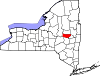
Location in the state of New York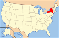
New York's location in the U.S.Founded March 12, 1772 Seat Fonda Area
- Total
- Land
- Water
410 sq mi (1,062 km²)
405 sq mi (1,049 km²)
6 sq mi (16 km²), 1.34%Population
- (2010)
- Density
50,219
124/sq mi (47.8/km²)Website www.co.montgomery.ny.us Montgomery County is a county located in the U.S. state of New York bordering the north bank of the Mohawk River. It was named in honor of Richard Montgomery, an American Revolutionary War general killed in 1775 at the Battle of Quebec. The county seat is Fonda.
Contents
History
- For the history of Montgomery County prior to 1784 see Tryon County, New York
In 1784, following end of the American Revolutionary War, the name of Tryon County was changed to Montgomery County. This change was to honor the general, Richard Montgomery, who had captured several places in Canada and died attempting to capture the city of Quebec, replacing the name of the British governor.
In 1789, Ontario County was split off from Montgomery. The area split off from Montgomery County was much larger than the present county, as it also included the present Allegany, Cattaraugus, Chautauqua, Erie, Genesee, Livingston, Monroe, Niagara, Orleans, Steuben, Wyoming, Yates, and part of Schuyler and Wayne counties.
In 1791, Herkimer, Otsego, and Tioga counties were split off from Montgomery.
In 1802, portions of Clinton, Herkimer, and Montgomery counties were combined to form St. Lawrence County.
In 1816, Hamilton County was split off from Montgomery.
In 1838, Fulton County was split off from Montgomery.
Congressional Districts
- 1789-1797 - None
- 1797-1803 - NY9
- 1803-1809 - NY13
- 1809-1813 - NY9
- 1813-1823 - NY14
- 1823-1833 - NY16
- 1833-1843 - NY15
- 1843-1853 - NY17
- 1853-1873 - NY18
- 1873-1875 - NY19
- 1875-1893 - NY20
- 1893-1913 - ?
- 1913-1945 - NY30
- 1945-1953 - NY31
- 1953-1963 - NY32
- 1963-1971 - NY35
- 1971-1973 - NY28 & NY29
- 1973-1983 - NY28 & NY31
- 1983-1993 - NY23 & ?
- 1993-2003 - NY21 & NY23
- 2003-Present - NY21
Geography
Montgomery County is located in the central part of the state, west of the city of Schenectady and northwest of Albany.
According to the U.S. Census Bureau, the county has a total area of 410 square miles (1,100 km2), of which 405 square miles (1,050 km2) is land and 6 square miles (16 km2) (1.34%) is water.
Adjacent counties
- Fulton County, New York - north
- Saratoga County, New York - east
- Schenectady County, New York - east
- Schoharie County, New York - south
- Otsego County, New York - southwest
- Herkimer County, New York - west
The Erie Canal runs through Montgomery County parallel to the Mohawk River and went west through the state to the Wood River. It connected Great Lakes shipping with the Hudson River. Several towns and villages grew up along the canal, as it carried much trade and passenger traffic during its peak years. After the railroad was built through the state, along the same river plain, it superseded the canal, which was filled in in some areas. In the mid-twentieth century, the NYS Thruway was constructed parallel to the former east-west routes of the canal and railroad.Today the Erie Canal and its lock system is used primarily for recreational boat use among locals and tourists. At the time of the canal's construction, Montgomery County was the only place where there was a break in the Appalachian Mountains. Called 'The Noses,' because of canal construction, it became known as "the gateway to the West".
Demographics
Historical populations Census Pop. %± 1790 28,848 — 1800 22,051 −23.6% 1810 41,214 86.9% 1820 37,569 −8.8% 1830 43,715 16.4% 1840 35,818 −18.1% 1850 31,992 −10.7% 1860 30,866 −3.5% 1870 34,457 11.6% 1880 38,315 11.2% 1890 45,699 19.3% 1900 47,488 3.9% 1910 57,567 21.2% 1920 57,928 0.6% 1930 60,076 3.7% 1940 59,142 −1.6% 1950 59,594 0.8% 1960 57,240 −4.0% 1970 55,883 −2.4% 1980 53,439 −4.4% 1990 51,981 −2.7% 2000 49,708 −4.4% 2010 50,219 1.0% [1] 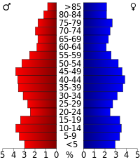 Montgomery County population distribution by age and sex (2000 census)
As of the census[2] of 2000, there were 49,708 people, 20,038 households, and 13,104 families residing in the county. The population density was 123 people per square mile (47/km²). There were 22,522 housing units at an average density of 56 per square mile (21/km²). The racial makeup of the county was 94.87% White, 1.15% African American, 0.25% Native American, 0.53% Asian, 0.01% Pacific Islander, 1.92% from other races, and 1.27% from two or more races. Hispanic or Latino of any race were 6.91% of the population. 19.0% were of Italian, 15.9% German, 13.5% Polish, 9.1% Irish, 7.9% American and 6.4% English ancestry according to Census 2000. 89.8% spoke English, 6.3% Spanish and 1.5% Polish as their first language.
There were 20,038 households out of which 29.40% had children under the age of 18 living with them, 49.00% were married couples living together, 11.60% had a female householder with no husband present, and 34.60% were non-families. 29.50% of all households were made up of individuals and 14.90% had someone living alone who was 65 years of age or older. The average household size was 2.42 and the average family size was 2.98.
In the county the population was spread out with 24.50% under the age of 18, 7.20% from 18 to 24, 26.30% from 25 to 44, 22.90% from 45 to 64, and 19.20% who were 65 years of age or older. The median age was 40 years. For every 100 females there were 91.40 males. For every 100 females age 18 and over, there were 87.90 males.
The median income for a household in the county was $32,128, and the median income for a family was $40,688. Males had a median income of $30,818 versus $23,359 for females. The per capita income for the county was $17,005. About 9.00% of families and 12.00% of the population were below the poverty line, including 16.80% of those under age 18 and 10.00% of those age 65 or over.
Cities and towns
- Ames (village)
- Amsterdam (city)
- Amsterdam (town)
- Canajoharie (town)
- Canajoharie (village)
- Charleston (town)
- Florida (town)
- Fonda (village)
- Fort Johnson (village)
- Fort Plain (village)
- Fultonville (village)
- Glen (town)
- Hagaman (village)
- Minden (town)
- Mohawk (town)
- Nelliston (village)
- Palatine Bridge (village)
- Palatine (town)
- Root (town)
- St. Johnsville (town)
- St. Johnsville (village)
- Labels in parentheses are official designations.
See also
- List of counties in New York
- National Register of Historic Places listings in Montgomery County, New York
References
- ^ http://factfinder2.census.gov
- ^ "American FactFinder". United States Census Bureau. http://factfinder.census.gov. Retrieved 2008-01-31.
External links
- Montgomery County, NY
- Montgomery County at the Open Directory Project
- Summary history of Montgomery County
- "Fulton-Montgomery Photo Archives"
- "Glovers and Tanners"

Fulton County Herkimer County 
Saratoga County and Schenectady County  Montgomery County, New York

Otsego County Schoharie County Municipalities and communities of Montgomery County, New York County seat: Fonda City 
Towns Amsterdam | Canajoharie | Charleston | Florida | Glen | Minden | Mohawk | Palatine | Root | St. Johnsville
Villages Ames | Canajoharie | Fonda | Fort Johnson | Fort Plain | Fultonville | Hagaman | Nelliston | Palatine Bridge | St. Johnsville
CDP Hamlets Capital District of New York Central communities Albany (History · City Hall · Coat of Arms) · Schenectady (City Hall) · Troy (History) · List of all incorporated places
Largest communities
(over 20,000 in 2000)Medium-sized communities
(10,000 to 20,000 in 2000)City of Amsterdam · Brunswick · Cohoes · East Greenbush · Glens Falls · Gloversville · Halfmoon · Malta · North Greenbush · Schodack · Watervliet · WiltonSmall communities
(5,000 to 10,000 in 2000)Town of Amsterdam · Ballston Spa · Cobleskill · Village of Colonie · Duanesburg · City of Johnstown · Town of Johnstown · Kinderhook · Mechanicville · New Scotland · Rensselaer · Sand Lake · Scotia · Town of Stillwater · WaterfordCounties Albany · Columbia · Fulton · Greene · Montgomery · Rensselaer · Saratoga · Schenectady · Schoharie · Warren · WashingtonHistory Mohawks · Mahicans · Fort Orange · Rensselaerswyck · Beverwyck · Albany Plan of Union · Timeline of town creation · Toponymies of places · Tech ValleyGeography Hudson River (Valley) · Mohawk River · Erie Canal · Lake Albany · Lake George · Albany Pine Bush (Rensselaer Lake · Woodlawn Preserve) · Adirondack Mountains · Catskill Mountains · Rensselaer PlateauReligion and culture Culture in New York's Capital District · Sports in New York's Capital District · Episcopal Diocese of Albany · Roman Catholic Diocese of AlbanyEducation Public school districtsList of school districts in New York's Capital DistrictHigher educationNewspapers TV/Radio Broadcast television in the Capital District Local stations WRGB (6.1 CBS, 6.2 This TV) • WTEN (10.1 ABC, 10.2 Weather, 10.3 RTV) • WNYT (13.1 NBC, 13.2 Weather, 13.3 Weather Radar) • WMHT (17.1 PBS, 17.2 ThinkBright, 17.3 HD) • WXXA (23.1 Fox, 23.2 The Cool TV) • WNGN-LP 35 / WNGX-LP 42 (FN) • WCWN (45.1 The CW, 45.2 Uni Sp) • WNYA / WNYA-CD (51.1 MNTV, 51.2 Antenna TV) • W52DF 52 (silent)
Outlying area stations WVBK-CA 2 (RSN' Manchester, VT) • W04AJ 4 (PBS; Glens Falls) • W04BD 4 (PBS; Schoharie) •
WNCE-CA 8 (A1; Glens Falls) • WYBN-CA 14 (RSN; Cobleskill) • WCDC (19.1 ABC; Adams, MA) • WVBG-LP 25 (RSN; Greenwich) • W36AX 36 (PBS / VPT; Manchester, VT) • W47CM 47 (silent; Glens Falls) • WYPX (55.1 Ion, 55.2 qubo, 55.3 Life; Amsterdam) • W53AS 53 (PBS / VPT; Bennington, VT)Adjacent locals Cable-only stations YNN Capital Region • TW3 • YES • SNY • MSG Network
Defunct stations New York State television: Albany/Schenectady • Binghamton • Buffalo • Burlington/Plattsburgh • Elmira • New York City • Rochester • Syracuse • Utica • Watertown
Vermont Broadcast television: Albany/Schenectady • Boston, MA • Burlington/Plattsburgh
Massachusetts television: Albany • Boston • Providence • Springfield
Radio stations in the Albany / Schenectady / Troy market by FM frequency 88.3 · 89.1² · 89.7 · 89.9 · 90.3/93.1² · 90.7/94.9 · 90.7 · 90.7 · 90.9 · 91.1 · 91.5 · 92.3 · 92.9 · 93.5 · 93.7 · 94.5 · 94.7 · 95.5 · 95.9 · 96.3 · 96.7² · 97.3 · 97.5 · 97.7 · 97.9 · 98.3² · 98.5 · 98.5 · 99.1 · 99.5² · 100.3 · 100.9 · 101.3 · 101.7 · 101.9 · 102.3² · 102.7 · 103.1² · 103.5 · 103.9 · 104.5 · 104.9 · 105.7² · 106.1 · 106.5² · 107.1 · 107.7²by AM frequency NOAA Weather Radio frequency 162.550by callsign W226AC · W235AY · W256BU · W291BY · WABY · WAJZ · WAMC (AM) · WAMC-FM² · WBAR · WBPM · WCDB · WCKL · WCKM · WCQL · WCSS · WCTW · WDCD · WDDY² · WENT · WEQX · WEXT · WFFG · WFLY · WFNY · WGDJ · WGNA² · WGXC · WGY¹² · WGY-FM² · WHAZ · WHAZ-FM · WHUC · WHVP · WIZR · WJIV · WKBE · WKKF² · WKLI · WLJH · WMHT² · WMYY · WNYQ · WOFX² · WOPG · WPGL · WPTR² · WPYX² · WQAR · WQBJ · WQBK · WQSH² · WRIP · WROW · WRPI · WRUC · WRVE² · WSDE · WTMM · WTRY² · WUAM · WVCR · WVKZ · WVTL · WXL34 · WYAI · WYJB · WYKV · WZCR · WZMRDefunct stations New York Radio Markets: Albany-Schenectady-Troy • Binghamton • Buffalo-Niagara Falls • Elmira-Corning • Hamptons-Riverhead • Ithaca • Nassau-Suffolk (Long Island) • New York City • Newburgh-Middletown (Mid Hudson Valley) • Olean • Plattsburgh • Poughkeepsie • Rochester • Syracuse • Utica-Rome • Watertown
Other New York Radio Regions: Jamestown-Dunkirk • North Country • Saratoga
See also: List of radio stations in New York Capital District PortalCategories:
- New York counties
- Montgomery County, New York
- 1772 establishments


Wikimedia Foundation. 2010.