- Cobleskill (town), New York
-
Cobleskill — Town — Location within the state of New York
 Cobleskill
Coordinates (seat of town government): 42°40′49″N 74°25′03″W / 42.68028°N 74.4175°WCoordinates: 42°40′49″N 74°25′03″W / 42.68028°N 74.4175°W Country United States State New York County Schoharie Settled c.1750 Established 1795 Government - Body Town board - Supervisor Tom Murray[1] (Democratic) Area - Total 30.8 sq mi (79.8 km2) - Land 30.6 sq mi (79.3 km2) - Water 0.2 sq mi (0.5 km2) Population (2000 Federal Census)[2] - Total 6,407 Time zone EST (UTC-5) - Summer (DST) DST (UTC-4) ZIP code 12043 Area code 518 Website http://www.schohariecounty-ny.gov/CountyWebSite/towncob/index.jsp Cobleskill is a town in Schoharie County, New York, USA. The population was 6,407 at the 2000 census.[2] The town contains a village, also named Cobleskill, as well as the State University of New York at Cobleskill.
The town is in the northern part of the county and is southwest of Amsterdam.
Contents
History
The town was first settled around 1712.
The town was founded at the same time as the county, 1795, but its boundaries were not established until 1801. There are more historical notes on the pages of Cobleskill (village), New York, Schoharie County, New York.
Battle of Cobleskill
Main article: Battle of CobleskillThe Cobleskill Militia, along with a few Continentals, were having a meeting at George Warner's house when the lookout spotted a party of Native Americans walking past. The soldiers pursued the Indians for a couple of miles when an army of 300-400 Indians, led by Joseph Brant, opened fire on the rebels. Of the 40 or so rebels, only about 11 got away without any major injuries
Geography
According to the United States Census Bureau, the town has a total area of 30.8 square miles (79.7 km²), of which, 30.6 square miles (79.3 km²) of it is land and 0.2 square miles (0.4 km²) of it (0.49%) is water.
Cobleskill Creek flows eastward through the town. Interstate 88 passes across the town. New York State Route 145 is an east-west highway, which runs conjointly with New York State Route 10 near Cobleskill village. Both the Interstate and NY-10 follow a route similar to Cobleskill Creek.
Two underground cavern complexes are open to tourists: [[]] and Secret Caverns. Both are north of I-88 and Howes Cave.
Demographics
As of the census of 2000, there were 6,407 people, 2,270 households, and 1,287 families residing in the town. The population density was 209.3 people per square mile (80.8/km²). There were 2,509 housing units at an average density of 81.9 per square mile (31.6/km²). The racial makeup of the town was 99.76% White,.62% Black or African American, 0.25% Native American, .01% Asian, 0.06% Pacific Islander, 0.53% from other races, and 1.17% from two or more races. Hispanic or Latino of any race were .34% of the population.[2]
There were 2,270 households out of which 26.5% had children under the age of 18 living with them, 43.1% were married couples living together, 10.0% had a female householder with no husband present, and 43.3% were non-families. 35.2% of all households were made up of individuals and 17.0% had someone living alone who was 65 years of age or older. The average household size was 2.23 and the average family size was 2.90.[2]
In the town the population was spread out with 18.4% under the age of 18, 24.9% from 18 to 24, 20.6% from 25 to 44, 19.7% from 45 to 64, and 16.4% who were 65 years of age or older. The median age was 33 years. For every 100 females there were 93.1 males. For every 100 females age 18 and over, there were 92.0 males.[2]
The median income for a household in the town was $32,764, and the median income for a family was $46,875. Males had a median income of $32,708 versus $24,864 for females. The per capita income for the town was $17,246. About 9.2% of families and 15.3% of the population were below the poverty line, including 18.1% of those under age 18 and 7.6% of those age 65 or over.[2]
Media outlets
See also: Media in New York's Capital District- WSDE 1990 AM News & Talk
- Times Journal of Cobleskill Weekly newspaper that comes out every Wednesday.
- SchoharieTV Local News Website ( http://www.schoharietv.com )
Communities and locations in the Town of Cobleskill
- Barnerville – A hamlet in the east part of the town, west of Bramanville on County Road 8.
- Bramanville – A hamlet in the east part of the town, west of Howes Cave on County Road 8.
- Cobleskill – A village located at the junction of NY-10 and NY-145 in the western part of the town.
- Cobleskill Reservoir – A reservoir east of Mineral Springs.
- East Cobleskill – A hamlet in the southeast part of the town at the town line on NY-145.
- Greenbush – A location south of Mineral Springs.
- Howes Cave – A hamlet near the east town line on County Road 8. The name is from early settler, Lester Howe.
- Lawyersville – A hamlet northwest of Cobleskill village, located on NY-145. The village is named after some early settlers.
- Mineral Springs – A hamlet south of Cobleskill village. It was originally called "Frances Corners."
- Russell Lake – A small lake at the northwest corner of Cobleskill.
- Sagendorf Corners – A location north of Howes Cave.
- Shutts Corners – A location northeast of Cobleskill village.
References
- ^ "Town of Cobleskill Home Page". http://www.schohariecounty-ny.gov/CountyWebSite/towncob/index.jsp. Retrieved July 21, 2010.
- ^ a b c d e f "American FactFinder". United States Census Bureau. http://factfinder.census.gov. Retrieved 2008-01-31.
External links
Capital District of New York Central communities Albany (History · City Hall · Coat of Arms) · Schenectady (City Hall) · Troy (History) · List of all incorporated places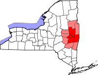
Largest communities
(over 20,000 in 2000)Medium-sized communities
(10,000 to 20,000 in 2000)City of Amsterdam · Brunswick · Cohoes · East Greenbush · Glens Falls · Gloversville · Halfmoon · Malta · North Greenbush · Schodack · Watervliet · WiltonSmall communities
(5,000 to 10,000 in 2000)Town of Amsterdam · Ballston Spa · Cobleskill · Village of Colonie · Duanesburg · City of Johnstown · Town of Johnstown · Kinderhook · Mechanicville · New Scotland · Rensselaer · Sand Lake · Scotia · Town of Stillwater · WaterfordCounties Albany · Columbia · Fulton · Greene · Montgomery · Rensselaer · Saratoga · Schenectady · Schoharie · Warren · WashingtonHistory Mohawks · Mahicans · Fort Orange · Rensselaerswyck · Beverwyck · Albany Plan of Union · Timeline of town creation · Toponymies of places · Tech ValleyGeography Hudson River (Valley) · Mohawk River · Erie Canal · Lake Albany · Lake George · Albany Pine Bush (Rensselaer Lake · Woodlawn Preserve) · Adirondack Mountains · Catskill Mountains · Rensselaer PlateauReligion and culture Culture in New York's Capital District · Sports in New York's Capital District · Episcopal Diocese of Albany · Roman Catholic Diocese of AlbanyEducation Public school districtsList of school districts in New York's Capital DistrictHigher educationNewspapers TV/Radio Broadcast television in the Capital District Local stations WRGB (6.1 CBS, 6.2 This TV) • WTEN (10.1 ABC, 10.2 Weather, 10.3 RTV) • WNYT (13.1 NBC, 13.2 Weather, 13.3 Weather Radar) • WMHT (17.1 PBS, 17.2 ThinkBright, 17.3 HD) • WXXA (23.1 Fox, 23.2 The Cool TV) • WNGN-LP 35 / WNGX-LP 42 (FN) • WCWN (45.1 The CW, 45.2 Uni Sp) • WNYA / WNYA-CD (51.1 MNTV, 51.2 Antenna TV) • W52DF 52 (silent)
Outlying area stations WVBK-CA 2 (RSN' Manchester, VT) • W04AJ 4 (PBS; Glens Falls) • W04BD 4 (PBS; Schoharie) •
WNCE-CA 8 (A1; Glens Falls) • WYBN-CA 14 (RSN; Cobleskill) • WCDC (19.1 ABC; Adams, MA) • WVBG-LP 25 (RSN; Greenwich) • W36AX 36 (PBS / VPT; Manchester, VT) • W47CM 47 (silent; Glens Falls) • WYPX (55.1 Ion, 55.2 qubo, 55.3 Life; Amsterdam) • W53AS 53 (PBS / VPT; Bennington, VT)Adjacent locals Cable-only stations YNN Capital Region • TW3 • YES • SNY • MSG Network
Defunct stations New York State television: Albany/Schenectady • Binghamton • Buffalo • Burlington/Plattsburgh • Elmira • New York City • Rochester • Syracuse • Utica • Watertown
Vermont Broadcast television: Albany/Schenectady • Boston, MA • Burlington/Plattsburgh
Massachusetts television: Albany • Boston • Providence • Springfield
Radio stations in the Albany / Schenectady / Troy market by FM frequency 88.3 · 89.1² · 89.7 · 89.9 · 90.3/93.1² · 90.7/94.9 · 90.7 · 90.7 · 90.9 · 91.1 · 91.5 · 92.3 · 92.9 · 93.5 · 93.7 · 94.5 · 94.7 · 95.5 · 95.9 · 96.3 · 96.7 · 97.3 · 97.5 · 97.7 · 97.9 · 98.3² · 98.5 · 98.5 · 99.1 · 99.5² · 100.3 · 100.9 · 101.3 · 101.7 · 101.9 · 102.3² · 102.7 · 103.1² · 103.5 · 103.9 · 104.5 · 104.9 · 105.7² · 106.1 · 106.5² · 107.1 · 107.7²by AM frequency NOAA Weather Radio frequency 162.550by callsign W226AC · W235AY · W256BU · W291BY · WABY · WAJZ · WAMC (AM) · WAMC-FM² · WBAR · WBPM · WCDB · WCKL · WCKM · WCQL · WCSS · WCTW · WDCD · WDCD-FM · WDDY² · WENT · WEQX · WEXT · WFFG · WFLY · WFNY · WGDJ · WGNA² · WGXC · WGY¹² · WGY-FM² · WHAZ · WHAZ-FM · WHUC · WHVP · WIZR · WJIV · WKBE · WKKF² · WKLI · WLJH · WMHT² · WMYY · WNYQ · WOFX² · WOPG · WPGL · WPYX² · WQAR · WQBJ · WQBK · WQSH² · WRIP · WROW · WRPI · WRUC · WRVE² · WSDE · WTMM · WTRY² · WUAM · WVCR · WVKZ · WVTL · WXL34 · WYAI · WYJB · WYKV · WZCR · WZMRDefunct stations New York Radio Markets: Albany-Schenectady-Troy • Binghamton • Buffalo-Niagara Falls • Elmira-Corning • Hamptons-Riverhead • Ithaca • Nassau-Suffolk (Long Island) • New York City • Newburgh-Middletown (Mid Hudson Valley) • Olean • Plattsburgh • Poughkeepsie • Rochester • Syracuse • Utica-Rome • Watertown
Other New York Radio Regions: Jamestown-Dunkirk • North Country • Saratoga
See also: List of radio stations in New YorkMunicipalities and communities of Schoharie County, New York Villages 
Towns Blenheim | Broome | Carlisle | Cobleskill | Conesville | Esperance | Fulton | Gilboa | Jefferson | Middleburgh | Richmondville | Schoharie | Seward | Sharon | Summit | Wright
Hamlets Breakabeen | Fultonham | Livingstonville | Sloansville | Warnerville
Categories:- Towns in New York
- Populated places in Schoharie County, New York


Wikimedia Foundation. 2010.