- Watervliet, New York
-
This article is about the current city of Watervliet, New York. For the former town of the same name from 1788–1896, see Watervliet (town), New York.
Watervliet City 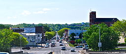 Watervliet as seen when entering the city on Congress Street Bridge from Troy
Official name: City of Watervliet Name origin: From Dutch for "water flood" Nickname: The Arsenal City Country United States State New York Region Capital District County Albany Landmark Watervliet Arsenal River Hudson Elevation 30 ft (9 m) Coordinates 42°43′29″N 73°42′22″W / 42.72472°N 73.70611°W Lowest point sea level - elevation 0 ft (0 m) Area 1.5 sq mi (4 km2) - land 1.3 sq mi (3 km2) - water 0.2 sq mi (1 km2) Population 10,254 (2010) Density 7,608.0 / sq mi (2,937 / km2) Incorporation as city 1896 Government City Hall - location 2 Fifteenth Street Watervliet, NY 12189
- coordinates 42°43′31″N 73°42′1″W / 42.72528°N 73.70028°W Mayor Michael Manning (D) General Manager - Charles J. Diamond (D)
- Ellen Fogarty (D)
Mark E. Gleason Timezone EST (UTC-5) - summer (DST) EDT (UTC-4) ZIP Code 12189 Area code 518 FIPS code 36-78674[1] GNIS feature ID 0968918[2] 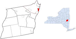 Location within Albany County and New York
Wikimedia Commons: Watervliet, New York Website: www.watervliet.com Watervliet (
 /ˈwɔːtərvliːt/ waw-tər-vleet or /ˈwɔːtərvəliːt/ waw-tər-və-leet) is a city in Albany County in the US state of New York. The population was 10,254 as of the 2010 census. Watervliet is north of Albany, the capital of the state, and is bordered on the north, west, and south by the town of Colonie. The city is also known as "the Arsenal City".
Contents
History
The explorer Henry Hudson arrived in the area of Watervliet around 1609. The area was first settled in 1643 as part of the Rensselaerswyck patroonship, under the direction of Kiliaen van Rensselaer. In 1710 Derrick van der Heyden operated a ferry from the Bleeker Farm (near 16th Street) across the Hudson River to Troy. Troops during the Revolutionary War used this ferry in 1777 on their way to Bemis Heights and Stillwater for the Battle of Saratoga. In 1786 a second ferry was started at Ferry Street (today 14th Street) over to Troy.[3] The town of Watervliet was founded in 1788 and included all of present-day Albany County except what was in the city of Albany at the time. Because so many towns had been created from the town of Watervliet, it is regarded as the "mother of towns" in the county.[citation needed] In 1816 the first post office was erected, corner of River and Ferry streets (Broadway and 14th Street), it took the name Watervliet.[3]
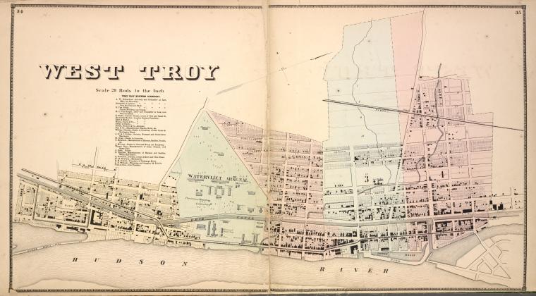
 West Troy in 1866
The location of the future city was taken by the village of Gibbonsville (1824) and its successor West Troy, and the hamlet of Washington (later Port Schuyler).[4] The farm owned by John Bleeker, stretching north from Buffalo Street (Broadway and 15th Street) to the farm owned by the Oothout family near 25th Street was purchased by Philip Schuyler, Isais Warren, Richard P. Hart, Nathan Warren, and others in 1823; they named it West Troy. Gibbonsville was the farm of James Gibbons (which he purchased in 1805), which stretched from North Street (8th Street) to Buffalo Street (15th Street).[3] Washington was settled sometime before 1814 and was the area south of Gibbonsville and today the area of Watervliet south of the Arsenal; it became known as Port Schuyler in 1827.[4] Although Gibbonsville and West Troy sat side-by-side (West Troy laying on Gibbonsville's northern boundary), there was a rivalry between the two and each named and laid out their streets with no regard to the street names and grids of the other.[4] In 1824 Gibbonsville became incorporated as a village, and in 1836 this was repealed when West Troy became incorporated as a village including Gibbonsville and Port Schuyler;[4] and in 1847 the Watervliet post office changed its name to West Troy.[5] In 1830 Gibbonsville had 559 people, West Troy 510, and Port Schuyler 450.[5]
In 1865 all of what is today Watervliet was included in the Capital Police Force within the Troy District, this regional attempt at consolidation of municipal police failed and in 1870 the West Troy Police Force was organized.[3]
By 1895 the town of Watervliet was reduced to the present-day city of Watervliet (village of West Troy at the time), town of Colonie, and the village/town of Green Island. Colonie would split off in 1895, and the city of Watervliet was incorporated in 1896 at the same time that Green Island became a town of its own.
In the early 19th century Watervliet became a major manufacturing community much like its neighbors Cohoes and Troy, thanks to bell foundries. The first was located on Water Street (Broadway), between 14th and 15th streets, by Julius Hanks, and the first bell foundry in Gibbonsville was established in 1826 by Andrew Menelly, Sr.[3] This would be the genesis of the Meneely Bell Foundry, which made thousands of bells that are still in use today from Iowa to the Czech Republic.
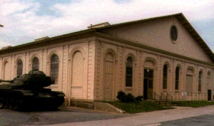
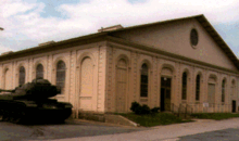 Historic Iron Building at Watervliet Arsenal
In 1813 the US Federal Government purchased from James Gibbons 12 acres (49,000 m2) in Gibbonsville, in 1828 another 30 acres (120,000 m2), along with later purchases from S.S. Wandell and others.[3] This land was used as the site for the Watervliet Arsenal, founded in 1813 during the War of 1812, it is the oldest Federal arsenal in the country; and is the sole manufacturing facility for large caliber cannon.[citation needed] John Morrissey, heavy-weight boxing champion and New York State Assemblyman was once employed at the Arsenal.[3]
The main route of the Erie Canal from Buffalo to Albany ran through Watervliet, and because the canal bypassed the city of Troy, the business community of Troy decided that a "short cut" was needed for convenient access to the Erie Canal without having to go through the Albany Basin. A side-cut to the Hudson was located at Watervliet's present-day 23rd Street (the Upper Side cut) finished in 1823,[4] and another just south of the Arsenal (the Lower Side cut).[6] A weigh station and a center for paying canal boat operators was located here as well.[citation needed] As a result of canal boat crews being paid at the end of their trip, the areas around the side cut was once famous for gambling, saloons, and prostitution; there were more than 25 saloons within two blocks,[6] with names like The Black Rag and Tub of Blood.[7] The neighborhood around the side cut had the nickname of "Barbary Coast of the East", Buffalo being the "Barbary Coast of the West".[6][7] In the 1880s Watervliet had a reputation for over 100 fights a day and a body once in the week in the Canal.[7]
Also linking Watervliet to the transportation network of the region was the Watervliet Turnpike and the Albany and Northern Railway. The Watervliet Turnpike Company in 1828 built present-day New York State Route 32 from the northern boundary of Albany north to the northern limit of Gibbonsville (now Broadway and 15th Street).[3] The Albany and Northern Railway was built 1852 connecting Watervliet to Albany, with a depot on Genesee Street; a few years later a new depot was built on Canal Street (Central Avenue) but was abandoned in favor of returning to the original location in 1864.[4]
The current mayor of Watervliet is Michael Manning, elected to his first term in 2007. Mr. Manning, a Democrat, defeated incumbent Mayor Robert Carlson in a rare Democratic primary election in September 2007.[8] Mr. Carlson had served as mayor of Watervliet for ten years.
Notable residents
Birthplace of veteran voice actor Joe Alaskey.
Birthplace of Medal of Honor recipient, T/Sgt. Peter J. Dalessondro.
Songwriter Tony Romeo, writer of "I Think I Love You" by The Partridge Family.
Geography
According to the United States Census Bureau, the city has a total area of 1.5 square miles (3.9 km2), of which, 1.3 square miles (3.4 km2) of it is land and 0.2 square miles (0.52 km2) of it (10.07%) is water.
Watervliet is on the west bank of the Hudson River. It is bordered on three sides by the town of Colonie; to the north by the hamlet of Maplewood, on the west by Latham and the hamlet of Mannsville, and on the south by the hamlet of Schuyler Heights. To the northeast is the town and village of Green Island. The Hudson River to the east is the boundary between Albany County and Rensselaer County, in Rensselaer County it is the city of Troy that borders Watervliet. The city is mostly flat but begins an extreme slope in the center of its most westerly edge, especially between the Watervliet Arsenal and 19th Street, an area once called "Temperance Hill".
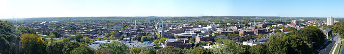 Panorama of Troy. Image taken from RPI's Experimental Media and Performing Arts Center, one block north of Congress Street. On the extreme right is Kennedy Towers. On the extreme left is the Empire State Plaza. Across the Hudson River in the center is the city of Watervliet.
Location

Town of Colonie Hamlet of Maplewood
Town and village of Green Island Town of Colonie Hamlets of Latham and Mannsville

Hudson River Rensselaer County City of Troy
 City of Watervliet

Town of Colonie Hamlet of Schuyler Heights and Schuyler Flatts Cultural Park
Demographics
Watervliet Historical Populations Year Pop. ±% 1840 4,572 — 1850 6,900 +50.9% 1860 8,952 +29.7% 1870 10,693 +19.4% 1880* 8,820 −17.5% 1890 12,967 +47.0% 1900 14,321 +10.4% 1910 15,074 +5.3% 1920 16,073 +6.6% 1930 16,083 +0.1% 1940 16,114 +0.2% 1950 15,197 −5.7% 1960 13,917 −8.4% 1970 12,404 −10.9% 1980 11,354 −8.5% 1990 11,061 −2.6% 2000 10,207 −7.7% 2010 10,254 +0.5% Notes: Census numbers for 1840 to 1890 are for the village of West Troy (incorporated 1836), which became the city of Watervliet in 1896.
*1880 census was not considered accurate and estimates put population at roughly 11,000*[5]As of the census[1] of 2000, there were 10,207 people, 4,665 households, and 2,547 families residing in the city. The population density was 7,608.0 people per square mile (2,941.0/km²). There were 5,116 housing units at an average density of 3,813.3 per square mile (1,474.1/km²). The racial makeup of the city was 92.00% White, 3.87% African American, 0.18% Native American, 1.34% Asian, 0.08% Pacific Islander, 1.21% from other races, and 1.33% from two or more races. Hispanic or Latino of any race were 3.62% of the population.
There were 4,665 households out of which 26.9% had children under the age of 18 living with them, 32.9% were married couples living together, 16.5% had a female householder with no husband present, and 45.4% were non-families. 38.3% of all households were made up of individuals and 16.4% had someone living alone who was 65 years of age or older. The average household size was 2.18 and the average family size was 2.91.
In the city the population was spread out with 23.7% under the age of 18, 9.6% from 18 to 24, 31.0% from 25 to 44, 19.7% from 45 to 64, and 16.0% who were 65 years of age or older. The median age was 35 years. For every 100 females there were 88.1 males. For every 100 females age 18 and over, there were 82.6 males.
The median income for a household in the city was $32,910, and the median income for a family was $38,735. Males had a median income of $31,656 versus $26,083 for females. The per capita income for the city was $18,294. About 12.3% of families and 13.3% of the population were below the poverty line, including 21.7% of those under age 18 and 5.7% of those age 65 or over.
References
- ^ a b "American FactFinder". United States Census Bureau. http://factfinder.census.gov. Retrieved 2008-01-31.
- ^ "US Board on Geographic Names". United States Geological Survey. 2007-10-25. http://geonames.usgs.gov. Retrieved 2008-01-31.
- ^ a b c d e f g h James T. Myers. "History of the City of Watervliet: 1630–1910". Henry Stowell & Son. http://www.archive.org/stream/historyofcityofw00myer/historyofcityofw00myer_djvu.txt. Retrieved 2009-12-31.
- ^ a b c d e f George Howell. Bi-centennial History of County of Albany, 1609–1886. W.W. Munsell & Company. pp. 974–993. http://books.google.com/books?id=XP9OXSEvvkYC&printsec=frontcover&dq=bi-centennial++history+of+county+of+albany. Retrieved 2009-04-05.
- ^ a b c Weise, Arthur James (1886). The city of Troy and its vicinity. Troy, New York: Edward Green. p. 341. OCLC 8989214. http://books.google.com/books?id=J1wVAAAAYAAJ.
- ^ a b c "Erie Canal". The Historical Marker Database. http://www.hmdb.org/Marker.asp?Marker=12214. Retrieved 2010-01-01.
- ^ a b c Lionel D. Wyld (1962). Low Bridge!: Folklore and the Erie Canal. Syracuse University Press. p. 71. http://books.google.com/books?id=ecGf3wtV1zQC&pg=RA1-PA71&lpg=RA1-PA71&dq=watervliet+barbary+coast+of+the+east#v=onepage&q=watervliet%20barbary%20coast%20of%20the%20east&f=false. Retrieved 2010-01-01.
- ^ "Primary Election Results". WRBG (Freedom Communications). 2007-09-18. http://www.cbs6albany.com/onset?id=24171&template=article.html.
External links
Capital District of New York Central communities Albany (History · City Hall · Coat of Arms) · Schenectady (City Hall) · Troy (History) · List of all incorporated places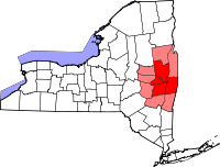
Largest communities
(over 20,000 in 2000)Medium-sized communities
(10,000 to 20,000 in 2000)City of Amsterdam · Brunswick · Cohoes · East Greenbush · Glens Falls · Gloversville · Halfmoon · Malta · North Greenbush · Schodack · Watervliet · WiltonSmall communities
(5,000 to 10,000 in 2000)Town of Amsterdam · Ballston Spa · Cobleskill · Village of Colonie · Duanesburg · City of Johnstown · Town of Johnstown · Kinderhook · Mechanicville · New Scotland · Rensselaer · Sand Lake · Scotia · Town of Stillwater · WaterfordCounties Albany · Columbia · Fulton · Greene · Montgomery · Rensselaer · Saratoga · Schenectady · Schoharie · Warren · WashingtonHistory Mohawks · Mahicans · Fort Orange · Rensselaerswyck · Beverwyck · Albany Plan of Union · Timeline of town creation · Toponymies of places · Tech ValleyGeography Hudson River (Valley) · Mohawk River · Erie Canal · Lake Albany · Lake George · Albany Pine Bush (Rensselaer Lake · Woodlawn Preserve) · Adirondack Mountains · Catskill Mountains · Rensselaer PlateauReligion and culture Culture in New York's Capital District · Sports in New York's Capital District · Episcopal Diocese of Albany · Roman Catholic Diocese of AlbanyEducation Public school districtsList of school districts in New York's Capital DistrictHigher educationNewspapers TV/Radio Broadcast television in the Capital District Local stations WRGB (6.1 CBS, 6.2 This TV) • WTEN (10.1 ABC, 10.2 Weather, 10.3 RTV) • WNYT (13.1 NBC, 13.2 Weather, 13.3 Weather Radar) • WMHT (17.1 PBS, 17.2 ThinkBright, 17.3 HD) • WXXA (23.1 Fox, 23.2 The Cool TV) • WNGN-LP 35 / WNGX-LP 42 (FN) • WCWN (45.1 The CW, 45.2 Uni Sp) • WNYA / WNYA-CD (51.1 MNTV, 51.2 Antenna TV) • W52DF 52 (silent)
Outlying area stations WVBK-CA 2 (RSN' Manchester, VT) • W04AJ 4 (PBS; Glens Falls) • W04BD 4 (PBS; Schoharie) •
WNCE-CA 8 (A1; Glens Falls) • WYBN-CA 14 (RSN; Cobleskill) • WCDC (19.1 ABC; Adams, MA) • WVBG-LP 25 (RSN; Greenwich) • W36AX 36 (PBS / VPT; Manchester, VT) • W47CM 47 (silent; Glens Falls) • WYPX (55.1 Ion, 55.2 qubo, 55.3 Life; Amsterdam) • W53AS 53 (PBS / VPT; Bennington, VT)Adjacent locals Cable-only stations YNN Capital Region • TW3 • YES • SNY • MSG Network
Defunct stations New York State television: Albany/Schenectady • Binghamton • Buffalo • Burlington/Plattsburgh • Elmira • New York City • Rochester • Syracuse • Utica • Watertown
Vermont Broadcast television: Albany/Schenectady • Boston, MA • Burlington/Plattsburgh
Massachusetts television: Albany • Boston • Providence • Springfield
Radio stations in the Albany / Schenectady / Troy market by FM frequency 88.3 · 89.1² · 89.7 · 89.9 · 90.3/93.1² · 90.7/94.9 · 90.7 · 90.7 · 90.9 · 91.1 · 91.5 · 92.3 · 92.9 · 93.5 · 93.7 · 94.5 · 94.7 · 95.5 · 95.9 · 96.3 · 96.7 · 97.3 · 97.5 · 97.7 · 97.9 · 98.3² · 98.5 · 98.5 · 99.1 · 99.5² · 100.3 · 100.9 · 101.3 · 101.7 · 101.9 · 102.3² · 102.7 · 103.1² · 103.5 · 103.9 · 104.5 · 104.9 · 105.7² · 106.1 · 106.5² · 107.1 · 107.7²by AM frequency NOAA Weather Radio frequency 162.550by callsign W226AC · W235AY · W256BU · W291BY · WABY · WAJZ · WAMC (AM) · WAMC-FM² · WBAR · WBPM · WCDB · WCKL · WCKM · WCQL · WCSS · WCTW · WDCD · WDCD-FM · WDDY² · WENT · WEQX · WEXT · WFFG · WFLY · WFNY · WGDJ · WGNA² · WGXC · WGY¹² · WGY-FM² · WHAZ · WHAZ-FM · WHUC · WHVP · WIZR · WJIV · WKBE · WKKF² · WKLI · WLJH · WMHT² · WMYY · WNYQ · WOFX² · WOPG · WPGL · WPYX² · WQAR · WQBJ · WQBK · WQSH² · WRIP · WROW · WRPI · WRUC · WRVE² · WSDE · WTMM · WTRY² · WUAM · WVCR · WVKZ · WVTL · WXL34 · WYAI · WYJB · WYKV · WZCR · WZMRDefunct stations New York Radio Markets: Albany-Schenectady-Troy • Binghamton • Buffalo-Niagara Falls • Elmira-Corning • Hamptons-Riverhead • Ithaca • Nassau-Suffolk (Long Island) • New York City • Newburgh-Middletown (Mid Hudson Valley) • Olean • Plattsburgh • Poughkeepsie • Rochester • Syracuse • Utica-Rome • Watertown
Other New York Radio Regions: Jamestown-Dunkirk • North Country • Saratoga
See also: List of radio stations in New YorkMunicipalities and communities of Albany County, New York Cities 
Towns Berne | Bethlehem | Coeymans | Colonie | Green Island | Guilderland | Knox | New Scotland | Rensselaerville | Westerlo
Villages Altamont | Colonie | Green Island | Menands | Ravena | Voorheesville
CDPs Other
hamletsAlcove | Boght Corners | Clarksville | Crescent Station | Dunsbach Ferry | Elsmere | Feura Bush | Fort Hunter | Fullers | Glenmont | Guilderland | Guilderland Center | Karner | Latham | Lisha Kill | Loudonville | Mannsville | McKownville | New Salem | Newtonville | Normansville | Roessleville | Selkirk | Slingerlands | South Bethlehem | Verdoy | West Albany
Categories:- Cities in New York
- Erie Canal
- Populated places in Albany County, New York


Wikimedia Foundation. 2010.