- Menands, New York
-
Menands Village 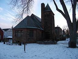 Bethany Presbyterian Church in Menands, New York
Official name: Village of Menands Name origin: For Louis Menand, an early landowner Motto: Urban-Suburban Village Country United States State New York Region Capital District County Albany Municipality Town of Colonie River Hudson Elevation 36 ft (11 m) Coordinates 42°41′36″N 73°43′37″W / 42.69333°N 73.72694°W Lowest point sea level - elevation 0 ft (0 m) Area 3.4 sq mi (9 km2) - land 3.2 sq mi (8 km2) - water 0.2 sq mi (1 km2) Population 3,990 (2010) Settled 1842 - Incorporation as Village 1924 Government Village Hall - location 250 Broadway, Albany, NY 12204 - coordinates 42°41′35″N 73°43′26″W / 42.69306°N 73.72389°W Mayor Thomas G. Coates (D) Timezone EST (UTC-5) - summer (DST) EDT (UTC-4) ZIP Code 12204 Area code 518 FIPS code 36-46536[1] GNIS feature ID 0956959[2] 
 Location in New York
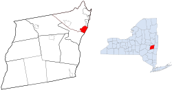 Location within Albany County and New York
Wikimedia Commons: Menands, New York Website: http://www.villageofmenands.com Menands is a village in Albany County, New York, United States. The population was 3,990 at the 2010 census. The village is named after Louis Menand. The village lies inside the town of Colonie and borders the north city line of Albany.
Contents
History
Menands would have been first spotted by Europeans in 1609 when Henry Hudson dropped anchor somewhere near Cuyler or Pleasure Island during his voyage on the river later to be named after him. This would be the furthest north on the river that Hudson would go in the Half Moon.[3] Today those islands are connected to the mainland, and are the site of Interstate 787 exits 6 and 7, which includes the cloverleaf interchange with NY 378 and the Troy-Menands Bridge.
Louis Menand settled in the village in 1842 and established an important horticultural business. He at first rented land that later became the Home for Aged Men, and then in 1847 bought 11 acres of land where the Albany-Watervliet Turnpike (today Broadway) met the road going to Ireland's Corners (today Loudonville), that road is today called Menand Road. When the Albany and Northern Railroad was built in 1856 it established a stop in present-day Menands and named the stop "Menand's Crossing" since Menand was the only landowner in that area at the time. When the Albany and Northern became part of the Delaware and Hudson a station was built at that stop and called "Menand's Station". In the early 1920s rumors circulated that the city of Albany was going to annex the area and so on August 23, 1924 a vote was taken and the village of Menands was incorporated by a vote of 167 for and 47 against, the population of the new village at that time being 1,272 people. The boundaries of the new village were those of the 15th School District of the town of Colonie. The original boundaries did not include what are now the Sage Hill Lane, Sky Hollow, and Roost Country Estates, those were annexed later and continue to be in the North Colonie Central School District.[4]
When the Erie Canal was originally constructed it passed through what would become Menands. Bridges spanned the canal to allow access to the land between the canal and the Hudson. From north to south they were- Richardson, Mix, Leary, Keyes, Kanes, Lundergans, Island Park, Delaware and Hudson Railroad, and Garbarance. Most of the names of the bridges were those of the neighboring farm owners.[4]
In 1938 the first large scale Federal Housing Administration multiple housing project in Upstate New York was conceived by Harry D. Yates on 13 acres (53,000 m2) of land in Menands.[4] The land was purchased for $20,000,[5] from the Van Rensselaer family who had owned it since 1639.[4] Original plans called for 30 buildings, but cost overruns trimmed it to 13. All thirteen were named for historic people and locations in the Capital District; subsequent additions have kept to that tradition with the exception of Tremaine House, named for a former NY State Comptroller and Yates House for a former manager of Dutch Village.[5] In 1940 the now-defunct New York Herald Tribune declared Dutch Village to be "one of the most interesting scale housing developments in the East". The steeped roofs and brick construction were designed to reflect early Dutch architecture. Wards Lane at the time was small and unpaved on a steep slope, but by using money from a federal program designed to pave "farm to market" roads the project was able to improve the road to Dutch Village without any cost to the village of Menands.[5]
The village's current motto, "Urban-Surburban Village," and its official seal, came into being as part of the village's 50th anniversary celebrations in 1974. The motto and seal were chosen based on contest entries submitted by local school children at Menands Elementary school. Two boys came up with the design for the seal, and the motto was chosen from an entry by a girl in the school's seventh grade class.
Amusement
In the mid-late 19th and early 20th centuries Menands was a popular destination for entertainment and amusement. Pleasure Island and Park Island (constructed in 1866) had trotting tracks and various entertainment venues.[6] In 1884 the Island Park Association leased the race course, Island Park, directly north of Pleasure Island, it was considered one of the fastest and safest in the nation.[7] Among the festivities and activities at Pleasure Island were a two-mile (3 km) bicycle race, a sack race, barrell race, swimming exhibition, trotter race, and fireworks.[8] In 1907 Al-Tro Island Park renovated Pleasure Island, Al-Tro was named for being halfway between Albany and Troy, and the park's manager boasted of surpassing Coney Island. The park had a 900-foot-long (270 m) and 40-foot-wide (12 m) boardwalk, with amusements on each side. About halfway down the boardwalk was an amphitheater that could seat 4000, it was one of the largest in the state.[9] At the time Al-Tro Park was considered the finest pleasure resort in northern New York.[10] In the early 1920s Al-Tro closed and the concept was used in the late 1920s by nearby Mid-City Park, an amusement park along Broadway on the other side away from the river, it had a roller coaster, merry-go-round, roller skating rink, and swimming pool; it too would close after a few decades.[8] It was replaced by the current Mid-City Shopping Center.
Baseball was also a popular entertainment venue in Menands bringing in spectators from across the region. Chadwick Park was home to the Albany Senators who played in the New York State League, Eastern League, International League, New York-Pennsylvania League, and the modern Eastern League.[citation needed] On May 30, 1924 the Senators played a double header at home against the Pittsfield Hillies, the first game lasted 9 innings but the second game went for 20, it is still one of the longest double headers by number of innings in professional baseball.[11] In 1928 Chadwick Park was rebuilt, in 1929 it was renamed Hawkins Stadium,[12] and in 1930 General Electric installed lights for night games.[13] It was at Hawkins Stadium that the New York Yankees played the Albany Senators in 1931 before a crowd of 6,300; Babe Ruth hit two home runs.[12] The Senators folded in 1959.[14] It too was demolished to make way for the Mid-City Shopping Center and a state office building for the New York State Office of Workmen’s Compensation.
From June 12, 1947 to September 2, 1963 Empire Raceways was a popular entertainment venue. It was a quarter mile paved oval track and was located close enough to the Hudson River that spectators would sit on the Troy-Menands Bridge and watch the races for free. The location would later become the site of a Two Guys Department Store and Interstate 787.[15]
Two Guys was just one of the retail locations in Menands that made Menands a shopping destination for the surrounding area. In addition to Two Guys there was a Woolworth, Montgomery Wards, several grocery stores, and various other shops along Broadway. The Two Guys location on Broadway, located next to the Troy-Menands Bridge, was one of only two in the area, the other being in downtown Schenectady.[citation needed] Another retail landmark in Menands was the Montgomery Ward Retail Store and Warehouse built in 1929, it was one of nine similar buildings built in the 1920s,[16] and one of four that still remain.[citation needed] The building had its own railroad spur that allowed boxcars to be unloaded inside, making delivery of goods to the building easier.[16] Montgomery Wards left the building in the 1970s. Today the building is office space, mostly geared towards state agencies.[16] Woolworth was located at the Mid-City Shopping Center, it closed in 1997.[17]
Famous residents
- George Deukmejian (1928-), 35th Governor of California, was born in Menands.
- Michael Holodak (1992-) Teen Entrepreneur and creator of Mike Made This tee-shirt designs
Geography
Menands is located at 42°41′36″N 73°43′37″W / 42.69333°N 73.72694°W (42.693245, -73.727068)[18].
According to the United States Census Bureau, the village has a total area of 3.4 square miles (8.8 km2), of which, 3.2 square miles (8.3 km2) of it is land and 0.2 square miles (0.52 km2) of it (6.45%) is water.
Menands is along the Hudson River on the west bank. The village is within the town of Colonie which is also to the north and west, with the city of Albany to the south. The village is mostly flat with a gentle slope to the west.
Location

Albany Rural Cemetery Hamlet of Schuyler Heights Hudson River Rensselaer County City of Troy
Albany Rural Cemetery Hamlet of Loudonville

Hudson River Rensselaer County Town of North Greenbush
 Village of Menands

City of Albany Demographics
Menands Historical Populations Year Pop. ±% 1930 1,522 — 1940 1,784 +17.2% 1950 2,453 +37.5% 1960 2,314 −5.7% 1970 3,449 +49.0% 1980 4,012 +16.3% 1990 4,333 +8.0% 2000 3,910 −9.8% 2010 3,990 +2.0% Note: Menands was incorporated in 1924, therefore the Censuses from 1790 to 1920 are not applicable to the village boundaries, which did not exist.
Sources: Censuses 1930, 1940, and 1950;[19] 1960, 1970, and 1980;[20] and 1990 and 2000.[1]As of the census[1] of 2000, there were 3,910 people, 1,906 households, and 968 families residing in the village. The population density was 1,225.1 people per square mile (473.2/km²). There were 2,073 housing units at an average density of 649.5 per square mile (250.9/km²). The racial makeup of the village was 83.76% White, 9.10% African American, 0.13% Native American, 4.35% Asian, 0.95% from other races, and 1.71% from two or more races. Hispanic or Latino of any race were 2.71% of the population.
There were 1,906 households out of which 20.2% had children under the age of 18 living with them, 39.5% were married couples living together, 8.3% had a female householder with no husband present, and 49.2% were non-families. 43.7% of all households were made up of individuals and 15.5% had someone living alone who was 65 years of age or older. The average household size was 2.00 and the average family size was 2.79.
In the village the population was spread out with 18.5% under the age of 18, 5.1% from 18 to 24, 29.5% from 25 to 44, 26.5% from 45 to 64, and 20.4% who were 65 years of age or older. The median age was 43 years. For every 100 females there were 86.7 males. For every 100 females age 18 and over, there were 83.9 males.
The median income for a household in the village was $48,456, and the median income for a family was $62,083. Males had a median income of $42,905 versus $31,745 for females. The per capita income for the village was $36,288. About 1.6% of families and 5.4% of the population were below the poverty line, including 4.1% of those under age 18 and 11.0% of those age 65 or over.
Important locations
- Albany Rural Cemetery- though most of the cemetery is outside the village, a portion along Cemetery Drive purchased by the cemetery in 1920 is within the village
- Troy-Menands Bridge- crosses the Hudson River and connects the village to the city of Troy
- Riverview Center- former Montgomery Ward store and distribution center, today this Art Deco office building houses video game developers Vicarious Visions and state workers, and has 1,000,000 sq ft (93,000 m2) of space.
- Capital District Farmers Market- The Capital District Cooperative, Inc., created in 1933, is one of the largest farmers markets in the region
References
- ^ a b c "American FactFinder". United States Census Bureau. http://factfinder.census.gov. Retrieved 2008-01-31.
- ^ "US Board on Geographic Names". United States Geological Survey. 2007-10-25. http://geonames.usgs.gov. Retrieved 2008-01-31.
- ^ Cuyler Reynolds (1906). Albany Chronicles. J.B. Lyon Company. p. 11. http://books.google.com/books?id=XNU0AAAAIAAJ&pg=PA11&dq=pleasure+island+albany&lr=&as_brr=1&cd=5#v=onepage&q=pleasure%20island%20albany&f=false. Retrieved 2009-12-24.
- ^ a b c d Howard Menand. "History of Menands". Village of Menands. http://google.com/search?q=cache:C0EHh_WWNXkJ:www.villageofmenands.com/Public_Documents/MenandsNY_Historian/menands_history.pdf+albany+lumber+district+fire&cd=22&hl=en&ct=clnk&gl=us. Retrieved 2009-07-18.
- ^ a b c Frances Ingraham (September 30, 1990). "Dutch Village revisited exhibition looks back 50 years at ambitious apartment project". Albany Times Union. http://archives.timesunion.com/mweb/wmsql.wm.request?oneimage&imageid=5546619. Retrieved 2009-12-25.
- ^ George Rogers Howell and Jonathan Tenney (1886). Bi-centennial history of Albany, N.Y. from 1609 to 1886. W.W. Munsell and Company. p. 945. http://books.google.com/books?id=nWkJAQAAIAAJ&pg=PA945&dq=pleasure+island+albany&lr=&as_brr=1&cd=2#v=onepage&q=pleasure%20island%20albany&f=false. Retrieved 2009-12-24.
- ^ Arthur James Weise (1886). The city of Troy and its vicinity. Edward Green. p. 179. http://books.google.com/books?id=J1wVAAAAYAAJ&pg=PA179&dq=pleasure+island+albany&lr=&as_brr=1&cd=36#v=onepage&q=pleasure%20island%20albany&f=false. Retrieved 2009-12-24.
- ^ a b Paul Grondahl (September 16, 2003). "Decades later, Pleasure Island resurfaces". Albany Times Union. http://www.colonie.org/historian/altro/tu_article.pdf. Retrieved 2009-12-24.
- ^ "Al-Tro Island Park in readiness for the public". The Sunday Record. June 30, 1985. http://www.colonie.org/historian/altro/record_article.pdf. Retrieved 2009-12-24.
- ^ The Motorman and Conductor. 13. 1905. p. 21. http://books.google.com/books?id=0go9AAAAIAAJ&pg=RA3-PA21&dq=al+tro+park&lr=&as_brr=1&cd=10#v=onepage&q=al%20tro%20park&f=false. Retrieved 2009-12-24.
- ^ "Appendix 7: Chronological listing of all doubleheader marathons of 26 or more innings, as well as listing by innings and evolution of records". The Society for American Baseball Research. http://www.sabr.org/cmsFiles/Files/Lowry_LongestGames_AppendixSeven.pdf. Retrieved 2009-12-24.
- ^ a b David Pietrusza. "David Pietrusza's Capital Region Baseball Timeline Part III: 1931-1950". http://www.davidpietrusza.com/capital-reg-baseball-3.html. Retrieved 2009-12-24.
- ^ Don Rittner (2008). Albany Revisited. Arcadia Publishing. p. 88. ISBN 978-0-7385-5652-9. http://books.google.com/books?id=-jsdfgEP0ZIC&pg=PA87&lpg=PA87&dq=chadwick+park+albany&source=bl&ots=4e_e4yjntr&sig=zP4qSH3jqPRJVZiNQa9PxMUgiI0&hl=en&ei=fxM0S4SVC82inQe8i5X4CA&sa=X&oi=book_result&ct=result&resnum=7&ved=0CBgQ6AEwBg#v=onepage&q=chadwick%20park%20albany&f=false.
- ^ Tim O'Brien (February 24, 2009). "Ball club to call Albany home". Albany Times Union. http://www.timesunion.com/AspStories/story.asp?storyID=773150. Retrieved 2009-12-24.[dead link]
- ^ "Empire Raceways". North American Motorsports/Krusty Motorsports. http://www.na-motorsports.com/Tracks/NY/Menands.html. Retrieved 2009-12-25.
- ^ a b c Robin Wood (December 17, 2004). "Old landmark has new lease on life". Albany Business Review. http://albany.bizjournals.com/albany/stories/2004/12/20/story1.html. Retrieved 2009-12-25.
- ^ Rachel Beck (July 18, 1997). "Woolworth to close all US stores". Albany Times Union. http://archives.timesunion.com/mweb/wmsql.wm.request?oneimage&imageid=5873976. Retrieved 2009-12-25.
- ^ "US Gazetteer files: 2010, 2000, and 1990". United States Census Bureau. 2011-02-12. http://www.census.gov/geo/www/gazetteer/gazette.html. Retrieved 2011-04-23.
- ^ "1950 Census of Population; Volume 1: Characteristics of the Population". United States Census Bureau. 1950. p. 32-16 (72 in PDF file). http://www2.census.gov/prod2/decennial/documents/23761117v1ch08.pdf. Retrieved 2010-02-13.
- ^ 1980 Census of Population; Volume 1: Characteristics of the Population. United States Census Bureau. 1980. p. 34-10. http://books.google.com/books?id=PpUXAAAAYAAJ&pg=SA34-PA10&dq=roessleville+1980+census&lr=&cd=4#v=onepage&q=roessleville%201980%20census&f=false. Retrieved 2010-02-13.
External links
- Menands Official website
- Menands Union Free School District
- Menands Police Department
- Menands Fire Company #1
- Town of Colonie Emergency Medical Services Department
Capital District of New York Central communities Albany (History · City Hall · Coat of Arms) · Schenectady (City Hall) · Troy (History) · List of all incorporated places
Largest communities
(over 20,000 in 2000)Medium-sized communities
(10,000 to 20,000 in 2000)City of Amsterdam · Brunswick · Cohoes · East Greenbush · Glens Falls · Gloversville · Halfmoon · Malta · North Greenbush · Schodack · Watervliet · WiltonSmall communities
(5,000 to 10,000 in 2000)Town of Amsterdam · Ballston Spa · Cobleskill · Village of Colonie · Duanesburg · City of Johnstown · Town of Johnstown · Kinderhook · Mechanicville · New Scotland · Rensselaer · Sand Lake · Scotia · Town of Stillwater · WaterfordCounties Albany · Columbia · Fulton · Greene · Montgomery · Rensselaer · Saratoga · Schenectady · Schoharie · Warren · WashingtonHistory Mohawks · Mahicans · Fort Orange · Rensselaerswyck · Beverwyck · Albany Plan of Union · Timeline of town creation · Toponymies of places · Tech ValleyGeography Hudson River (Valley) · Mohawk River · Erie Canal · Lake Albany · Lake George · Albany Pine Bush (Rensselaer Lake · Woodlawn Preserve) · Adirondack Mountains · Catskill Mountains · Rensselaer PlateauReligion and culture Culture in New York's Capital District · Sports in New York's Capital District · Episcopal Diocese of Albany · Roman Catholic Diocese of AlbanyEducation Public school districtsList of school districts in New York's Capital DistrictHigher educationNewspapers TV/Radio Broadcast television in the Capital District Local stations WRGB (6.1 CBS, 6.2 This TV) • WTEN (10.1 ABC, 10.2 Weather, 10.3 RTV) • WNYT (13.1 NBC, 13.2 Weather, 13.3 Weather Radar) • WMHT (17.1 PBS, 17.2 ThinkBright, 17.3 HD) • WXXA (23.1 Fox, 23.2 The Cool TV) • WNGN-LP 35 / WNGX-LP 42 (FN) • WCWN (45.1 The CW, 45.2 Uni Sp) • WNYA / WNYA-CD (51.1 MNTV, 51.2 Antenna TV) • W52DF 52 (silent)
Outlying area stations WVBK-CA 2 (RSN' Manchester, VT) • W04AJ 4 (PBS; Glens Falls) • W04BD 4 (PBS; Schoharie) •
WNCE-CA 8 (A1; Glens Falls) • WYBN-CA 14 (RSN; Cobleskill) • WCDC (19.1 ABC; Adams, MA) • WVBG-LP 25 (RSN; Greenwich) • W36AX 36 (PBS / VPT; Manchester, VT) • W47CM 47 (silent; Glens Falls) • WYPX (55.1 Ion, 55.2 qubo, 55.3 Life; Amsterdam) • W53AS 53 (PBS / VPT; Bennington, VT)Adjacent locals Cable-only stations YNN Capital Region • TW3 • YES • SNY • MSG Network
Defunct stations New York State television: Albany/Schenectady • Binghamton • Buffalo • Burlington/Plattsburgh • Elmira • New York City • Rochester • Syracuse • Utica • Watertown
Vermont Broadcast television: Albany/Schenectady • Boston, MA • Burlington/Plattsburgh
Massachusetts television: Albany • Boston • Providence • Springfield
Radio stations in the Albany / Schenectady / Troy market by FM frequency 88.3 · 89.1² · 89.7 · 89.9 · 90.3/93.1² · 90.7/94.9 · 90.7 · 90.7 · 90.9 · 91.1 · 91.5 · 92.3 · 92.9 · 93.5 · 93.7 · 94.5 · 94.7 · 95.5 · 95.9 · 96.3 · 96.7 · 97.3 · 97.5 · 97.7 · 97.9 · 98.3² · 98.5 · 98.5 · 99.1 · 99.5² · 100.3 · 100.9 · 101.3 · 101.7 · 101.9 · 102.3² · 102.7 · 103.1² · 103.5 · 103.9 · 104.5 · 104.9 · 105.7² · 106.1 · 106.5² · 107.1 · 107.7²by AM frequency NOAA Weather Radio frequency 162.550by callsign W226AC · W235AY · W256BU · W291BY · WABY · WAJZ · WAMC (AM) · WAMC-FM² · WBAR · WBPM · WCDB · WCKL · WCKM · WCQL · WCSS · WCTW · WDCD · WDCD-FM · WDDY² · WENT · WEQX · WEXT · WFFG · WFLY · WFNY · WGDJ · WGNA² · WGXC · WGY¹² · WGY-FM² · WHAZ · WHAZ-FM · WHUC · WHVP · WIZR · WJIV · WKBE · WKKF² · WKLI · WLJH · WMHT² · WMYY · WNYQ · WOFX² · WOPG · WPGL · WPYX² · WQAR · WQBJ · WQBK · WQSH² · WRIP · WROW · WRPI · WRUC · WRVE² · WSDE · WTMM · WTRY² · WUAM · WVCR · WVKZ · WVTL · WXL34 · WYAI · WYJB · WYKV · WZCR · WZMRDefunct stations New York Radio Markets: Albany-Schenectady-Troy • Binghamton • Buffalo-Niagara Falls • Elmira-Corning • Hamptons-Riverhead • Ithaca • Nassau-Suffolk (Long Island) • New York City • Newburgh-Middletown (Mid Hudson Valley) • Olean • Plattsburgh • Poughkeepsie • Rochester • Syracuse • Utica-Rome • Watertown
Other New York Radio Regions: Jamestown-Dunkirk • North Country • Saratoga
See also: List of radio stations in New YorkMunicipalities and communities of Albany County, New York Cities Albany | Cohoes | Watervliet

Towns Berne | Bethlehem | Coeymans | Colonie | Green Island | Guilderland | Knox | New Scotland | Rensselaerville | Westerlo
Villages Altamont | Colonie | Green Island | Menands | Ravena | Voorheesville
CDPs Other
hamletsAlcove | Boght Corners | Clarksville | Crescent Station | Dunsbach Ferry | Elsmere | Feura Bush | Fort Hunter | Fullers | Glenmont | Guilderland | Guilderland Center | Karner | Latham | Lisha Kill | Loudonville | Mannsville | McKownville | New Salem | Newtonville | Normansville | Roessleville | Selkirk | Slingerlands | South Bethlehem | Verdoy | West Albany
Categories:- Villages in New York
- Colonie, New York
- Populated places on the Hudson River
- Populated places in Albany County, New York


Wikimedia Foundation. 2010.