- Manchester (town), Vermont
-
 Bennington County Courthouse
 Manchester, Vermont
Manchester is a town in, and one of two shire towns[1] (county seats)[2] of, Bennington County, Vermont, United States. The population was 4,180 at the 2000 census.
Manchester Village, an incorporated village, and Manchester Center are settlement centers within the town.
Manchester has become a tourist destination, especially for those from New York and Connecticut, offering visitors factory outlet stores of national chain retailers such as Brooks Brothers and Ralph Lauren, as well as many locally owned businesses, including the Northshire Bookstore, one of America's leading independent bookstores.
Contents
History
 View of Manchester in 1913
The town was one of several chartered in 1761 by Benning Wentworth, colonial governor of New Hampshire. It was his custom to name new towns after prominent English aristocrats of the day, hoping they might adopt a patronly interest in their namesakes. Wentworth named Manchester for Robert Montagu, 3rd Duke of Manchester. First settled in 1764, the town was laid out in 1784. The land was better suited for grazing than tillage, so by 1839 about 6000 sheep roamed the pasturage and hillsides.
Other industries came to include iron mines, marble quarries and mills, and lumber companies. The arrival of the railroad from industrialized centers like New York City brought tourists, drawn by Manchester's historic architecture and beautiful setting among mountains. Following the Civil War, the town developed into an affluent resort area, which it remains today.
Between 1812 and 1819 Manchester was made famous by the Boorn-Colvin case, called "America's first wrongful conviction murder case" [3], the subject of several books and still studied today.[4].
Geography
According to the United States Census Bureau, the town has a total area of 42.3 square miles (109.5 km2), of which, 42.2 square miles (109.4 km2) of it is land and 0.1 square miles (0.1 km2) of it (0.12%) is water. Manchester is drained by the Batten Kill, Lye Brook, Munson Brook, Bromley Brook, and Bourn Brook. The town lies between the Green Mountains to the east and the Taconic Range to the west. Equinox Mountain, the highest summit in the Taconics, has an elevation of 3,850 feet (1,175 m).
The town is crossed by
 U.S. Route 7 and 7A, as well as
  Vermont Route 30 and
  Vermont Route 11.
Demographics
As of the census[5] of 2000, there were 4,180 people, 1,819 households, and 1,156 families residing in the town. The population density was 99.0 people per square mile (38.2/km2). There were 2,456 housing units at an average density of 58.2 per square mile (22.5/km2). The racial makeup of the town was 97.87% White, 0.38% Black or African American, 0.17% Native American, 0.31% Asian, 0.43% from other races, and 0.84% from two or more races. Hispanic or Latino of any race were 1.75% of the population.
There were 1,819 households out of which 28.5% had children under the age of 18 living with them, 51.5% were married couples who were living together, 9.5% had a female householder with no husband present, and 36.4% were non-families. 30.5% of all households were made up of individuals and 14.0% had someone living alone who was 65 years of age or older. The average household size was 2.26 and the average family size was 2.81.
In the town the population was spread out with 23.1% under the age of 18, 4.0% from 18 to 24, 25.0% from 25 to 44, 28.8% from 45 to 64, and 19.1% who were 65 years of age or older. The median age was 44 years. For every 100 females there were 87.9 males. For every 100 females age 18 and over, there were 84.3 males.
The median income for a household in the town was $47,196, and the median income for a family was $59,191. Males had a median income of $36,453 versus $26,017 for females. The per capita income for the town was $30,499. About 2.2% of families and 4.6% of the population were below the poverty line, including 1.9% of those under age 18 and 6.5% of those age 65 or over.
Notable people
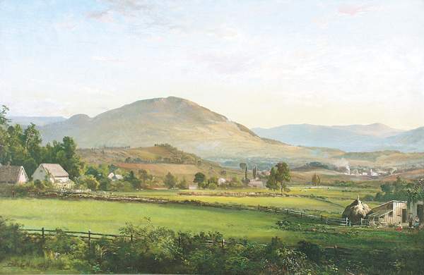
 View of Manchester, Vermont by DeWitt Clinton Boutelle (1870)
- Charles Augustus Aiken, clergyman, president of Union College, professor at Princeton University.
- Joseph Sweetman Ames, physicist, president of Johns Hopkins University.
- Edmund Bennett, judge and educator.
- Myra Bradwell, first American woman to become an attorney.
- James M. Clarke, congressman.
- Jeremiah French, soldier, judge and political figure in Upper Canada.
- Jonathan Goldsmith, actor
- Robert Todd Lincoln, first son of Abraham Lincoln.
- Ahiman Louis Miner, congressman.
- Benjamin S. Roberts, Civil War general.
- The Samples, alternative rock band.[citation needed]
- Clara Sipprell, photographer.
- Richard Skinner, jurist and congressman.
- Treat Williams, movie and television actor.
- Sarah Norcliffe Cleghorn, poetess, feminist, suffragist
See also
References
- ^ Title 24, Part I, Chapter 1, §3, Vermont Statutes. Accessed 2007-11-01.
- ^ "Find a County". National Association of Counties. http://www.naco.org/Counties/Pages/FindACounty.aspx. Retrieved 2011-06-07.
- ^ https://www.law.northwestern.edu/wrongfulconvictions/exonerations/vtBoornSummary.html
- ^ http://murderbygasslight.blogspot.com/2010/04/dead-alive.html
- ^ "American FactFinder". United States Census Bureau. http://factfinder.census.gov. Retrieved 2008-01-31.
External links
- Town of Manchester, Vermont
- Mark Skinner Library
- Manchester Historical Society & Museum
- Manchester and the Mountains Vermont Regional Chamber of Commerce
- History of Manchester, Vermont (1839)
Coordinates: 43°09′42″N 73°04′19″W / 43.1617°N 73.0719°W
Municipalities and communities of Bennington County, Vermont Towns Arlington | Bennington | Dorset | Glastenbury‡ | Landgrove | Manchester | Peru | Pownal | Readsboro | Rupert | Sandgate | Searsburg | Shaftsbury | Stamford | Sunderland | Winhall | Woodford

Villages CDPs Footnotes ‡ Disincorporated
Categories:- Towns in Vermont
- Manchester, Vermont
- County seats in Vermont
- Populated places in Bennington County, Vermont


Wikimedia Foundation. 2010.