- Pownal, Vermont
-
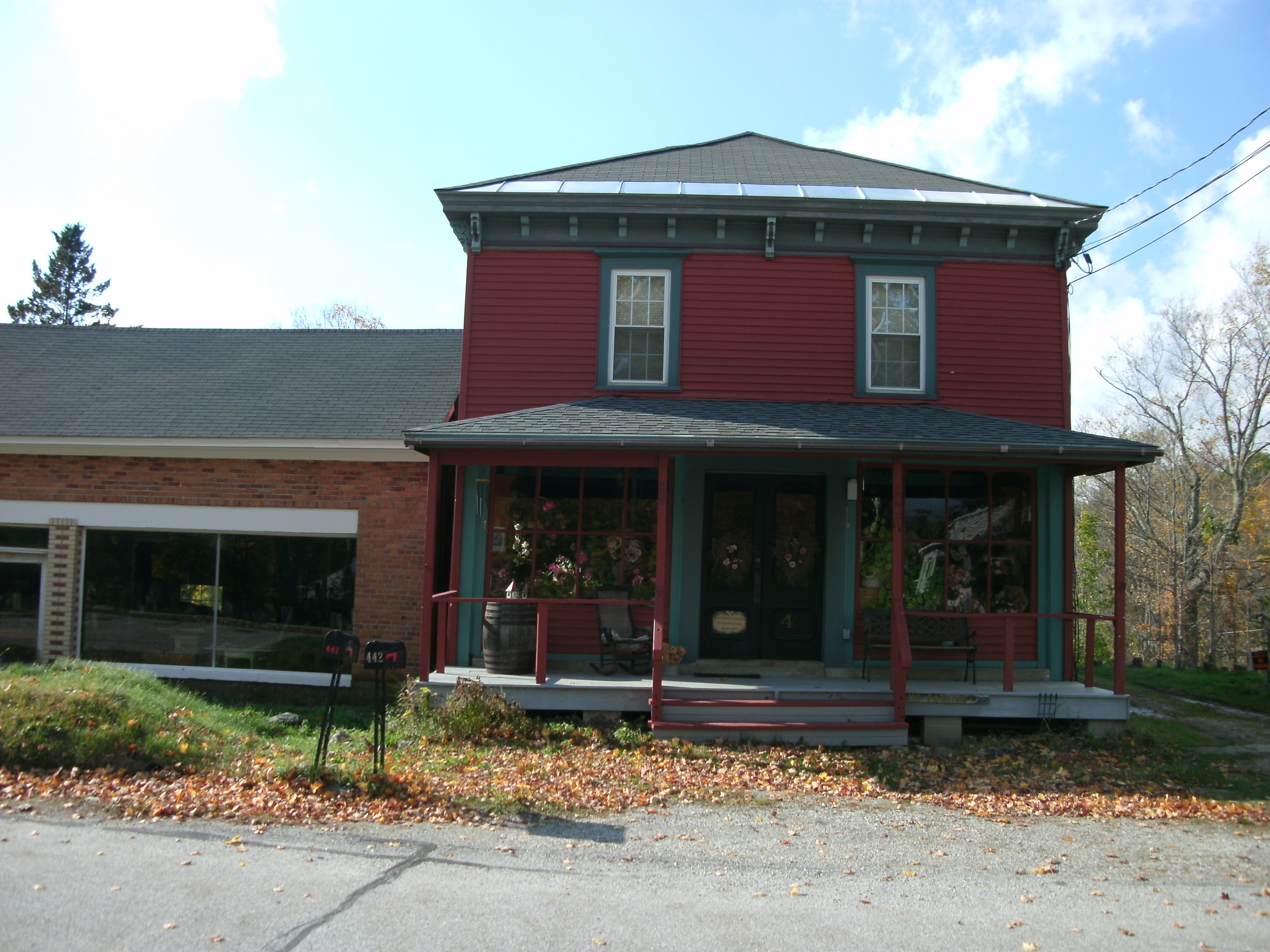
Pownal, Vermont — Town — Former Country Store Pownal, Vermont
Coordinates: 42°48′N 73°13′W / 42.8°N 73.217°WCoordinates: 42°48′N 73°13′W / 42.8°N 73.217°W Country United States State Vermont County Bennington Area – Total 46.7 sq mi (121.0 km2) – Land 46.7 sq mi (120.8 km2) – Water 0.1 sq mi (0.2 km2) Elevation 1,398 ft (426 m) Population (2000) – Total 3,560 – Density 76.3/sq mi (29.5/km2) Time zone Eastern (EST) (UTC-5) – Summer (DST) EDT (UTC-4) ZIP code 05261 Area code(s) 802 FIPS code 50-57025[1] GNIS feature ID 1462179[2] Pownal is a town in Bennington County, Vermont, United States. As of the 2000 census, the town population was 3,560. The town of Pownal includes the villages of Pownal, North Pownal, and Pownal Center.
Contents
History
During the Woodland period, the area was settled by the Mahican people, with others, such as the Mohawks, traveling across it. By the late 17th century, Europeans may have entered the area as a result of the establishment of the Dutch patroonship owned by Kiliaen van Rensselaer, the Manor of Rensselaerswyck, which extended west and east out of Albany and the fur trading community of Beverwyck. The southwestern corner of Pownal was part of the patroonship.[citation needed] Rensselaerswyck passed into English control in 1664. The first European settlers may have entered the area in the 1730s.[3] Those first European settlers may have been Dutch or other Europeans who leased land within Rensselaerwyck. On January 28, 1760, New Hampshire Governor Benning Wentworth chartered Pownal, which he named after his fellow royal governor, Thomas Pownall of the Massachusetts Bay Colony.[4]
Thereafter, Settlers, primarily of English descent, began to arrive from Massachusetts, Connecticut and Rhode Island. In 1766, 185 male heads of households in Pownal sent a petition to George III, asking that their land claims be recognized and that the fees required to do so be waived. Since Wentworth had granted to settlers land that the Province of New York also claimed, legal and physical conflicts broke out between "Yorkers" and settlers in the New Hampshire Grants (or "The Grants"). As a result, a number of Pownal residents joined the Green Mountain Boys under Ethan Allen.
By the Revolution, the town was deeply divided between “Yankees” and the Tories, those sympathetic to England, each of whom considered himself or herself a Loyalist. Tories were often arrested and imprisoned. By the end of the Revolution, most Tories had fled Pownal for safety among the United Empire Loyalists who resettled in Canada. As noted, however, that was not always the case. William Card (1710–1784), born in Rhode Island, settled in Pownal perhaps as late as 1773 (though his sons settled there between 1762–1766) fought for the British at the Battle of Bennington on 16 August 1777, along with four of his sons: Jonathan (1734–1818), Elisha (1738–1805), Philo (1754–1837) , Stephen (1748–1798) -- (Source: National Archives of Canada, WO 28/10, Reel B-2867, pp. 17–18. Found on the NY GenWeb Rensselaer County, The Loyalist Muster Roll of 1777 by Capt Samuel McKay at Chateauguay, Quebec, 20TH DECEMBER 1777.) The battle, a virtually complete American victory, was actually fought in Hoosick Falls (Walloomsac), NY. The elder Card and all four of his sons were captured, but soon released.
Three years later, William Card's grandsons (Jonathan Card's [1734-1818] two young sons), Thomas (1762–1850) and Jonathan (1764–1836), would serve in Colonel Herrick's Vermont regiment on the "Yankee" or Patriot lines during 1780/1. Their service was documented in their Revolutionary War pension papers as men who fought against the British (HeritageQuest Revolutionary War Papers Series: M805 Roll: 160 Image: 31 File: S12447 Pages: 1-7 and Series: M805 Roll: 160 Image: 89 File: S10430 Pages: 1-8). Wm Card died in Pownal in 1784, seven years later. The War, in New England, was over well before that.
The novel Memoir of a Green Mountain Boy starts and ends in Pownal during the early years of the Revolution.
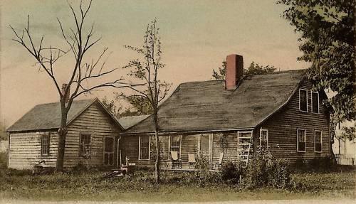
 The Mooar-Wright House in 1909
The oldest house in both Pownal and Vermont is the Mooar-Wright House, possibly built in the 1750s. Some think it may have been built by John Defoe (or DeVoet), a Tory who was imprisoned in 1776, escaped, fought on the side of the British and Hessian forces at the Battle of Bennington, was captured, escaped again, and settled in Canada. Others believe the Mooar-Wright house was built by Charles Wright in 1765.
Pownal citizens have long prided themselves on their independent spirit. In 1789, a touring minister, the Rev. Nathan Perkins, described the town this way: “ . . . Pawnal ye first town, poor land – very unpleasant – very uneven – miserable set of inhabitants – no religion, Rhode Island haters of religion – Baptists, quakers, & some Presbyterians – no meeting house.”
Today Pownal has five churches. The Pownal Center Community Church was organized in 1794 as the Union Church, serving both Baptists and Methodists, and open to any denomination. The first church was a log structure. It was replaced in 1849 by the present church, jointly owned by the town and church.

In 1851, Chester Arthur (later to become President of the United States), was appointed principal to an academy for boys. The academy prepared boys for college (and became the foundation for Arthur's future path to study law).[5]
Both cotton mills and woolen mills operated during the 19th century. The wool industry reached its peak between 1820 and 1840, though farmers continued to raise sheep until the 20th century.[6] On the Hoosic River in North Pownal, an 18th-century gristmill was replaced by a woolen mill that operated from 1849 until 1863, when it burned. The Plunkett & Baker Co. Mill, built in 1866, served as a cotton mill until 1930, becoming a tannery in 1937. It closed in 1988. Remediated as a superfund site, the mill site is planned to become a recreation area.
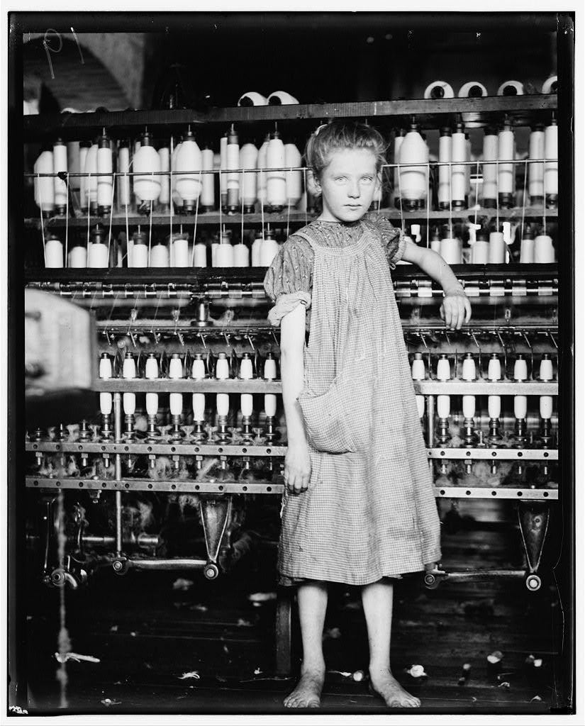
During the early part of the 20th century, Lewis Hine documented child labor in the mills. His photograph of twelve-year old Addie Card, entitled “Anemic Little Spinner in North Pownal Cotton Mill, North Pownal, Vermont, August 1910,” was featured on the U.S. stamp commemorating the passage of the first child labor laws (see the Keating-Owen Act). Elizabeth Winthrop has written a novel, Counting on Grace, inspired by Addie’s photograph and life.
An electric railroad came to Pownal on June 7, 1907, and linked Pownal to The Berkshires and to Bennington. The brick power station still stands along Route 7. Schools were built in locations to which children could easily walk, and at one point Pownal had 11 schools, with four men and eleven women teaching in them. Two presidents of the United States once taught in North Pownal: James Garfield and Chester A. Arthur. Some children who attended high school in Bennington commuted on the electric railroad. Others rode wagons or horses to their schools.
Lime quarries operated in North Pownal until 1936. A rail car line extended from the southernmost quarry to the mill on the west side of Route 346, where the stone was crushed and packaged for shipment.
Green Mountain Race Track
Pownal was formerly the home of Green Mountain Race Track. Opened in 1963, the track offered both thoroughbred and standardbred horse racing until 1976, when thoroughbred racing ceased, replaced by greyhound racing. One year later, standardbred racing was discontinued, and the track thereafter featured only greyhound racing until closing altogether in 1992 amid pressure from animal rights activists, who objected to greyhound racing as cruel (Vermont banned the sport in 1995). Since closing as a racetrack, the site has hosted live events occasionally, including a rock concert in the Lollapalooza series in 1996, and antique car shows from 2005 to 2008. The 144-acre (0.58 km2) property has been purchased by commercial developers, whose plans for it have not yet been finalized, but are believed to include a mix of energy-efficient companies, a farmers' market facility, and facilities to accommodate large events.
The year 2010 will mark the 250th anniversary of Pownal's charter, and organizers are scheduling commemorative events throughout the year.
Geography
Pownal is the southwesternmost town in Vermont; it is bordered by Williamstown, Massachusetts to the south and Petersburgh, New York to the west. Pownal also borders the towns of Stamford to the east, Woodford to the northeast, and Bennington to the north.
Like many towns in Bennington County, Pownal is much closer to New York's state capital of Albany than to its own state capital of Montpelier.
According to the United States Census Bureau, the town has a total area of 46.7 square miles (121.0 km2), of which 46.7 square miles (120.8 km2) is land and 0.1 square mile (0.2 km2) (0.17%) is water. Pownal is drained by the Hoosic River.
The town is crossed by two state-maintained highways: U.S. Route 7, which is the town's main road; and Vermont Route 346, a short route that begins at U.S. 7 at the village of Pownal and runs northwestward (along the Hoosic River) to the New York state line.
Demographics
As of the census[1] of 2000, there were 3,560 people, 1,373 households, and 1,010 families residing in the town. The population density was 76.3 people per square mile (29.5/km2). There were 1,563 housing units at an average density of 33.5 per square mile (12.9/km2). The racial makeup of the town was 97.84% White, 0.28% African American, 0.42% Native American, 0.56% Asian, 0.20% from other races, and 0.70% from two or more races. Hispanic or Latino of any race were 0.42% of the population.
There were 1,373 households out of which 34.0% had children under the age of 18 living with them, 58.0% were married couples living together, 11.4% had a female householder with no husband present, and 26.4% were non-families. 19.7% of all households were made up of individuals and 6.3% had someone living alone who was 65 years of age or older. The average household size was 2.59 and the average family size was 2.95.
In the town the population was spread out with 25.4% under the age of 18, 7.6% from 18 to 24, 28.9% from 25 to 44, 27.0% from 45 to 64, and 11.1% who were 65 years of age or older. The median age was 38 years. For every 100 females there were 103.2 males. For every 100 females age 18 and over, there were 96.0 males.
The median income for a household in the town was $39,149, and the median income for a family was $41,006. Males had a median income of $30,753 versus $24,212 for females. The per capita income for the town was $17,669. About 8.5% of families and 9.6% of the population were below the poverty line, including 16.9% of those under age 18 and 1.8% of those age 65 or over.
References
- ^ a b "American FactFinder". United States Census Bureau. http://factfinder.census.gov. Retrieved 2008-01-31.
- ^ "US Board on Geographic Names". United States Geological Survey. 2007-10-25. http://geonames.usgs.gov. Retrieved 2008-01-31.
- ^ Hayward's New England Gazetteer of 1839
- ^ Austin J. Coolidge & John B. Mansfield, A History and Description of New England; Boston, Massachusetts 1859
- ^ new york times.
- ^ Hayward's New England Gazetteer of 1839
Brasser, Ted J. "Riding on the Frontier's Crest: Mahican Indian Culture and Culture Change", Ottawa: National Museums of Canada, 1974.
Brown, William Bradford. "Sketches of Pownal." North Adams, MA: North Adams Transcript, n.d. [1]
Hall, Hiland. History of Vermont from Its Discovery to Its Admission into the Union in 1791. Albany, NY: Joel Munsell, 1868.
Hemenway, Abby Maria (ed.). Vermont Quarterly Gazetteer. Vol. I. Ludlow, VT: Author, 1861
Niles, Grace Greylock. The Hoosac Valley—Its Legends and History. New York: The Knickerbocker Press, 1912. Reprint. Heritage Books.
Pownal Historical Society. Images of America: Pownal Portsmouth, ME: Arcadia Publishing, 2010.
Parks, Joe. Pownal: A Vermont Town's Two Hundred Years and More. Pownal, VT: Pownal Bicentennial Committee, 1977.
“New Hampshire Grants -- Being Transcripts of the Charters of Townships and Minor Grants of Lands Made by the Provincial Government of New Hampshire, within the Present Boundaries of the State of Vermont, From 1749 to 1764.” New Hampshire State Papers, Vol. XXVI, Concord, NH.
External links
- Town of Pownal, Vermont
- Solomon Wright Public Library
- Pownal Historical Society
- Virtual Vermont -- Pownal, Vermont
- Current Pownal Information
- Superfund Cleanup Site and Grants
- Pownal History
Municipalities and communities of Bennington County, Vermont Towns Arlington | Bennington | Dorset | Glastenbury‡ | Landgrove | Manchester | Peru | Pownal | Readsboro | Rupert | Sandgate | Searsburg | Shaftsbury | Stamford | Sunderland | Winhall | Woodford

Villages CDPs Footnotes ‡ Disincorporated
Categories:- Towns in Vermont
- Pownal, Vermont
- Populated places in Bennington County, Vermont


Wikimedia Foundation. 2010.