- Interstate 88 (east)
Infobox road
state=NY
type=I
route=88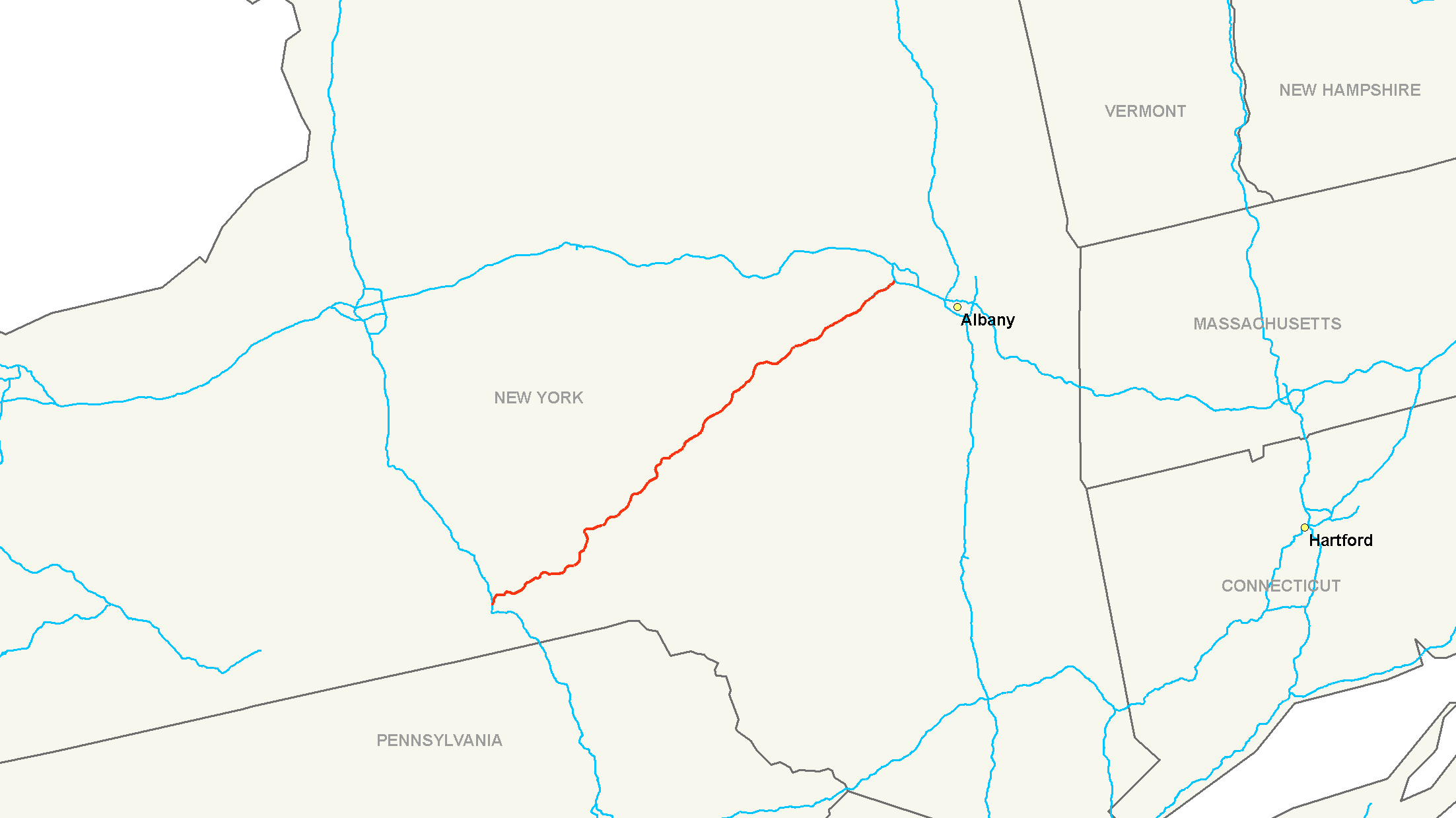
alternate_name=Senator Warren M. Anderson Expressway, Susquehanna Expressway
maint=NYSDOT
length_mi=117.75
length_round=2
length_ref=cite web|url=http://www.fhwa.dot.gov/reports/routefinder/table1.cfm|title=FHWA Route Log and Finder List: Table 1 - Interstate System - Design|accessdate=2007-03-21|date=2002-10-31|format=CFM|work=|publisher=Federal Highway Administration ]
established=1968 (completed 1989)
direction_a=West
terminus_a=Jct|state=NY|I|81 in Fenton
junction=Jct|state=NY|US|20 near Duanesburg
direction_b=East
terminus_b=Jct|state=NY|I|90|NYST in Rotterdam
previous_type=I
previous_route=87
next_type=NY
next_route=88Interstate 88 (I-88) is an
Interstate highway entirely within theU.S. state ofNew York . Its western end is atInterstate 81 in Binghamton and its eastern end is atInterstate 90 in Schenectady. It serves as an important connector route from Albany to Binghamton, Elmira (via NY 17/future I-86), andScranton, Pennsylvania (via I-81). It runs nearNew York State Route 7 , which was once the main route through the area, for its entire length.Route description
Binghamton to Oneonta
I-88 begins at an interchange with Interstate 81 just north of downtown Binghamton on the banks of the
Chenango River . While both directions of I-81 are accessible from I-88 westbound, only one direction of I-81 (northbound) connects to I-88. The missing connection, I-81 south to I-88 east, is made via U.S. Route 11, NY 12 and NY 12A at I-81 exit 6. NY 12A then connects to I-88 at exit 2.From I-81, I-88 heads east across the Chenango to Port Dickinson, where it merges with the limited-access NY 7 at exit 1. The two routes continue north, then east along the eastern bank of the Chenango River, where it meets NY 12A near Chenango Bridge. I-88 and NY 7 remain alongside the river to Port Crane, where the river begins to follow NY 369 (exit 3) northward. Outside of Port Crane, the expressway heads east to Sanitaria Springs. Here, NY 7 leaves the expressway at exit 4 and begins to parallel I-88, as it does for the remainder of I-88's routing.
I-88 continues east to Harpursville, interchanging with NY 79 (exit 6) near the center of the community. Shortly after meeting NY 79, I-88 reenters a river valley, this time that of the
Susquehanna River . I-88 heads to the northeast, following the river and NY 7 toBainbridge, New York where it meets NY State Route 206 and then on to Sidney, where it meets NY 8, the primary north-south road through the village, at exit 9. From Sidney, I-88 progresses northeast through southern Otsego County, passing Unadilla before entering Oneonta. Within the city, I-88 interchanges with NY 205 ahead of an exit with NY 28. NY 28 joins the expressway, following I-88 out of the city.Oneonta to Schenectady
Northeast of Oneonta, NY 28 leaves I-88 at exit 17 to follow the Susquehanna River northward toward Cooperstown. I-88, however, remains on a northeasterly track through rural eastern Otsego County. Upon crossing into Schoharie County, I-88 begins to follow an easterly routing as it heads toward Cobleskill. While NY 7 enters the village, I-88 passes south of it, connecting to the village via two exits with NY 7. East of Cobleskill, I-88 interchanges with NY 145.
Howe Caverns , a regionally popular attraction, is located a short distance north of the exit. I-88 continues onward, skirting the northern edge of Schoharie before passing into Schenectady County.Shortly after entering Schenectady County, I-88 meets U.S. Route 20 east of Duanesburg. Past US 20, I-88 continues northeast, interchanging with NY 7 for one final time before ending at the
New York State Thruway (Interstate 90) in western Schenectady.History
I-88 was added to the
Interstate Highway System onDecember 13 ,1968 cite web|url=http://www.fhwa.dot.gov/interstate/previousfacts.cfm|title=Previous Interstate Facts of the Day|publisher=FHWA|accessdate=2007-10-30] although all convert|118|mi|km of the route had yet to be constructed. [cite map|url=http://www.broermapsonline.org/members/NorthAmerica/UnitedStates/Midatlantic/gousha_ra_1967_004.html|title=Gousha Road Atlas|year=1967|publisher=Gousha |accessdate=2007-10-30] Construction began on I-88 soon afterward and continued throughout the 1970s. By 1985, I-88 was completed between Port Dickinson and Schenectady.cite map|publisher=Rand McNally |title=New York|year=1985|cartography=Rand McNally ] In 1989, construction concluded on I-88 with the opening of the final portion of I-88 between its current terminus at Interstate 81 and NY 7 in Port Dickinson.cite map|url=ftp://ftp.dot.state.pa.us/public/pdf/BPR_pdf_files/Maps/Statewide/Historic_OTMs/1989fr.pdf|title=Pennsylvania Official Transportation Map|publisher=Pennsylvania Department of Transportation |year=1989|accessdate=2007-10-30]2006 flood
As a result of the June 2006 flooding in upstate
New York and northeasternPennsylvania ,Carr's Creek washed out a convert|50|ft|m|sing=on long section of Interstate 88 southwest of Unadilla on June 28. [cite news|url=http://www.pressconnects.com/apps/pbcs.dll/article?AID=/20060629/NEWS01/101220028/-1/flood|title=Driver killed in I-88 bridge collapse identified|author=Jim Wright|work=Binghamton Press & Sun-Bulletin |date=2006-06-29 |accessdate=2007-10-30] Around 6:20 a.m., two trucks from different directions drove into the chasm, apparently unaware of it, killing both drivers. David Swingle, 42, of Waverly, who was driving eastbound, was identified shortly after the accident. [cite news|url=http://www.usatoday.com/weather/news/2006-06-28-upstate-flooding_x.htm|title=Waters slowly recede, residents begin cleaning up|author=William Kates|work=USA Today |date=2006-06-29 |accessdate=2007-10-30] The westbound trucker was Patrick O'Connell, 55, ofLisbon, Maine . [cite news|url=http://www.news10now.com/content/top_stories/default.asp?ArID=71727|title=Victim in truck accident identified|publisher=News 10 Now |date=2006-07-03 |accessdate=2007-10-31] His body was found downstream several days after the water receded. [cite news|url=http://www.newsday.com/news/local/wire/newyork/ny-bc-ny-brf--missing-truck0708jul08,0,2143290.story?coll=ny-region-apnewyork|title=Body of trucker killed in storms found|work=Newsday |date=2006-07-08 ]The
New York State Department of Transportation started construction to replace the section of highway almost immediately, and it was re-opened August 31. [cite web|url=https://www.nysdot.gov/portal/page/portal/news/press-releases/2006/31|title=Governor Pataki Tours and Announces the Reopening of I-88|date=2006-08-31 |accessdate=2007-10-30] Families of both victims plan to sue the state of New York for the incidents. [cite web|url=http://www.thedailystar.com/news/stories/2006/10/19/deaths1119.html|title=Suits pending in I-88 flood deaths|accessdate=2007-03-21]Exit list
References
Wikimedia Foundation. 2010.