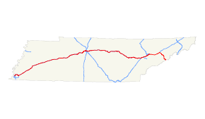
- Interstate 40 in Tennessee
-
Interstate 40
Route information Maintained by TDOT Length: 455.28 mi (732.70 km) Major junctions West end:  I-40 at Arkansas state line
 I-69 / I-240 in Memphis
 I-440 in Nashville
 I-65 in Nashville
 I-24 in Nashville
 I-140 in Knoxville

 I-75 / I-640 in Knoxville
 I-275 in Knoxville
 I-81 in Dandridge
East end:  I-40 at North Carolina state line
Location Counties: Shelby, Fayette, Haywood, Madison, Henderson, Carroll, Decatur, Humphreys, Hickman, Dickson, Williamson, Cheatham, Davidson, Wilson, Smith, Putnam, Cumberland, Roane, Loudon, Knox, Sevier, Jefferson, Cocke Highway system Main route of the Interstate Highway System
Main • Auxiliary • BusinessTennessee State Routes
Interstate • US←  SR-39
SR-39SR-40  →
→In the state of Tennessee, Interstate 40 traverses the entirety of the state from west to east, running from the Mississippi River at the Arkansas border to the northern base of the Great Smoky Mountains at the North Carolina border. The road connects Tennessee's three largest cities—Memphis, Nashville, and Knoxville—and crosses all of Tennessee's physiographical provinces—the Mississippi Embayment and Gulf Coastal Plain in West Tennessee, the Highland Rim and Nashville Basin in Middle Tennessee, and the Cumberland Plateau, Appalachian Valley and Ridge Province, and Blue Ridge Province in East Tennessee. The Tennessee section of I-40 is 455 miles (732 km) long, the longest of any state.
Contents
Route description
West Tennessee

Interstate 40 enters Tennessee from Arkansas via the Hernando de Soto Bridge, which spans the Mississippi River at River Mile 736. The interstate passes across the southern half of Mud Island before crossing the Wolf River into downtown Memphis. At the I-240 interchange, I-40 abrubtly turns north, following the route redesignated due to the Overton Park controversy in the 1970s.
The first 130 miles (210 km) of the interstate in Tennessee are relatively flat as the road traverses the Gulf Coastal Plain. At Mile 78, the road crosses the South Fork Forked Deer River into Jackson, Tennessee, and from Jackson proceeds through the northern half of Natchez Trace State Park. At Mile 135, I-40 crosses the Tennessee River into Middle Tennessee.
Middle Tennessee
East of the Tennessee River, the rugged hills of the Western Highland Rim flank I-40 for a considerable stretch before the interstate descends to the Nashville Basin between Miles 186 and 188. In Downtown Nashville, I-40 converges with Interstate 24 and Interstate 65, making Nashville one of just four cities in the United States where six interstate legs converge within the city's boundaries. Before and after I-40 converges into I-24 and I-65, I-40 is named Needles Freeway and Blue Star Memeorial Highway.[1] At Mile 219, the interstate crosses the Stones River just downstream from Percy Priest Dam, and continues for roughly 50 miles (80 km) across mostly open farmland.
Between Miles 263 and 266, I-40 crosses the meandering Caney Fork five times before ascending the Eastern Highland Rim, reaching 1,000 feet (300 m) for the first time in the state near Silver Point. The interstate steadies at the edge of the table-top rim at Mile 272 (near Baxter) and continues across relatively flat farmland in south Cookeville. Between Miles 292 and 297, the interstate ascends the western escarpment of the Cumberland Plateau, reaching 2,000 feet (610 m) southeast of Monterey. At Mile 308, I-40 crosses the Tennessee Divide, where the Cumberland and Tennessee River watersheds meet (in the eastbound lane, the divide is marked by a sign reading "Entering Emory River watershed"; its westbound lane counterpart notes the beginning of the Caney Fork watershed).
East Tennessee
 I-40 descending Walden Ridge, Miles 341-346
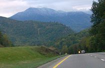
I-40 remains relatively steady as it continues across the Cumberland Plateau and passes through the northern part of Crossville. East of Crossville, the Crab Orchard Mountains (the southern fringe of the Cumberland Mountains) come into view as the road descends several hundred feet. At Mile 329, the interstate enters Crab Orchard Gap and proceeds through a narrow valley once prone to rockslides. At Mile 340, the interstate enters the Eastern Time Zone, and shortly thereafter the road begins its descent of the Cumberland Plateau into the Tennessee Valley. I-40 hugs the slopes of the plateau's Walden Ridge escarpment for several miles— with dramatic views of the Tennessee Valley below to the south— before reaching the base of the plateau at Mile 347 between Harriman and Rockwood.
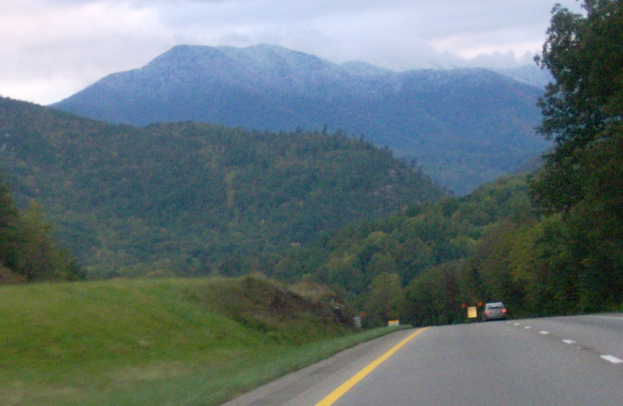
 I-40 near Mile 441, with Mount Cammerer rising in the distance
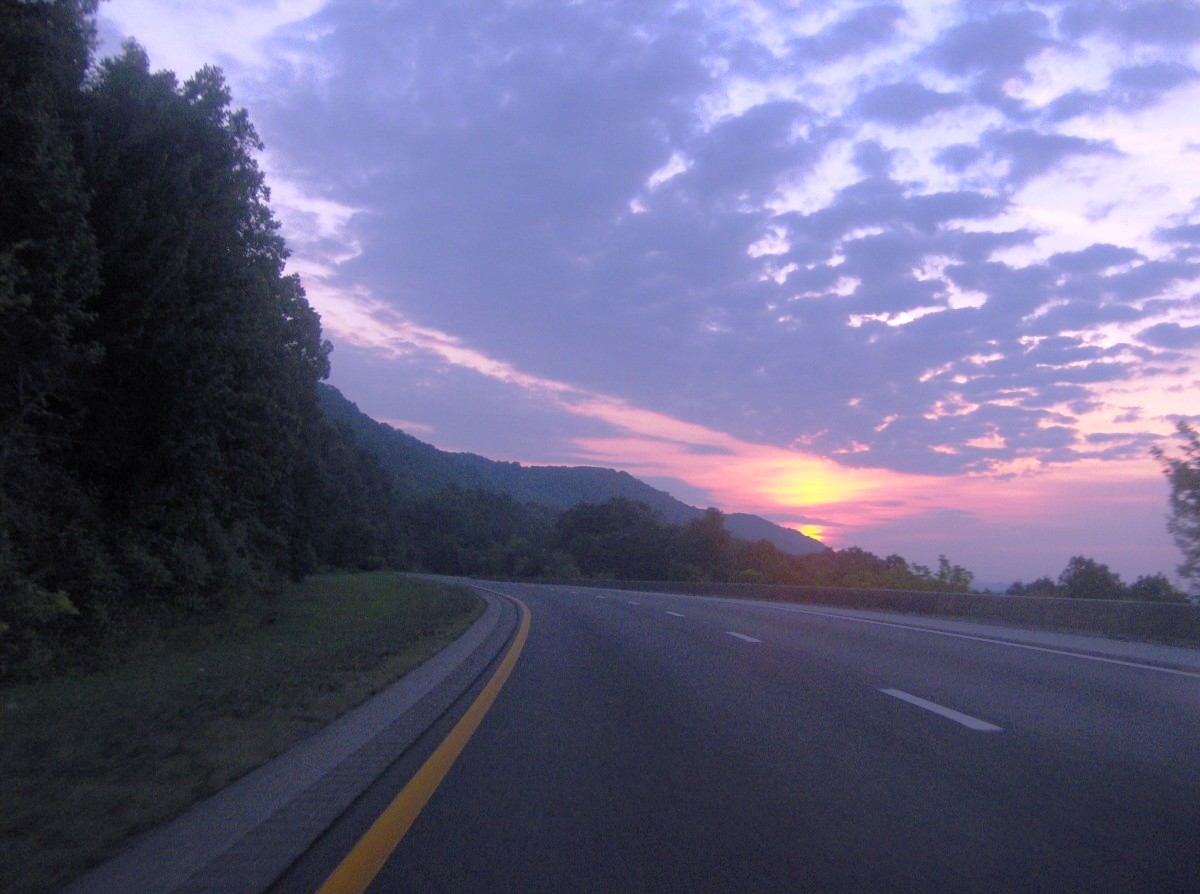
As it enters the Ridge-and-Valley province (of which the Tennessee Valley is a part), I-40 crosses a series of ridges and valleys characteristic of the region's topography. At Mile 351, the road crosses the Clinch River, with the Kingston Fossil Plant and its 1,000 ft (300 m) twin smokestacks dominating the view to the north. The road widens to four lanes at Mile 368 as I-40 merges with Interstate 75. Knoxville's skyline comes into view at Mile 387 before the road passes through downtown Knoxville.
Beyond Knoxville, the interstate crosses the Holston and French Broad rivers (the French Broad is much wider due to its impoundment by Douglas Dam a few miles downstream) and continues for several miles along the northern base of English Mountain. At Mile 440, the road turns south through the gap between English Mountain and Stone Mountain, revealing a dramatic view of the 4,928-foot (1,502 m) Mount Cammerer at the northeastern end of the Great Smokies range, and the road proceeds into the Pigeon River Gorge, closely following the north bank of the river. The massive mesh nets on the cliffslopes are indicative of the rockslide prevention measures along this stretch of I-40.
Music Highway
The term Music Highway refers to a section of I-40 between Memphis and Nashville. I-40 was designated as such by an act of the Tennessee legislature in 1997 "from the eastern boundary of Davidson County to the Mississippi River in Shelby County," a distance of about 222 miles. Interstate 40 is desingated as such because of the rich music history in Memphis, Nashville, and the areas in between them. Memphis is known as "The Home of the Blues and the Birthplace of Rock and Roll." Nashville is known as "Music City USA" for its influence on numerous types of music, especially country. Several cities and towns between the two, such as Jackson, Brownsville, Nutbush (Near Ripley), Waverly and others were birthplaces or homes of numerous singers and songwriters. Signs that display the words "Music Highway" along with music notes are erected in both directions along Interstate 40, especially at the borders of Shelby County and Davidson County (Nashville).[2]
History
The Tennessee leg of Interstate 40 was part of the original 1,047 miles (1,685 km) of interstate highways authorized for Tennessee by the Federal Aid Highway Act of 1956. The first section of Interstate 40— Nonconnah Creek to Hindman Ferry Road in Shelby County— was contracted in 1956, and within a year contracts had been awarded for sections in Davidson, Knox, Roane, Haywood, Madison, Jefferson, and Cocke counties. By 1958, sections in Loudon, Smith, Putnam, Cumberland, Humphreys, Hickman, and Sevier counties had been contracted. Most of Interstate 40 had been completed by the late 1960s.[3]
In Memphis, I-40 was originally slated to pass through the city's Overton Park, a 342-acre (138 ha) wooded refuge that had become an important stopover for migratory birds. Fearing that the interstate's construction would upset the park's fragile ecological balance, environmentalists waged a 12-year legal battle to prevent highway construction in the park, culminating in the United States Supreme Court decision, Citizens to Preserve Overton Park v. Volpe. The Supreme Court remanded the case to the district court for further review, and the district ruled that the highway commission had not adequately explored alternative routes. In 1981, the highway commission abandoned plans to route I-40 through Overton Park, and instead redesignated the northern portion of Interstate 240 as Interstate 40.[4] For over 20 years, I-40 signage existed on the dead-end route toward Overton Park. Several miles of interstate were actually built within the Interstate 240 loop; this portion of highway still exists and is in regular use as Sam Cooper Boulevard, reaching the eastern end of Chickasaw Country Club.
Geological difficulties
Rockslides
The rugged terrain of East Tennessee presented numerous challenges for I-40 construction crews and engineers. Rockslides, especially along the eastern Cumberland Plateau and in the Pigeon River Gorge, have been a persistent problem since the road's construction. Twenty rockslides occurred along the Walden Ridge section (Miles 341-346) of the eastern plateau in 1968 alone, prompting various remedial measures throughout the 1970s, including the employment of rock buttresses, gabion walls, and horizontal drains. In December 1986, a truck driver was killed when his truck skidded across some rocks that had spilled across the road just east of Crab Orchard (between Miles 331 and 333). In response, the Tennessee Department of Transportation (TDOT) flattened the cutslopes along this stretch of interstate and moved the road 60 feet (18 m) away from the problematic cliffside.[5]
Another area prone to rockslides is the Pigeon River Gorge, especially in the vicinity of the Tennessee-North Carolina state line. Throughout the 1970s, this stretch of I-40 was repeatedly shut down by rockslides, sometimes for several weeks at a time. In the late 1970s and early 1980s, TDOT dug over 24,000 feet (7,300 m) of horizontal drains, blasted out large volumes of unstable rocks, and installed massive mesh catchment fences.[5] Nevertheless, rockslides in 1985 and 1997 again forced the closure of I-40 in the Pigeon River Gorge for several weeks.[6] Additional stabilization measures were implemented, including the blasting of loose rock, the installation of rock bolts, and the construction of a better drainage system.[7] In spite of these measures, another massive rock slide occurred in the Pigeon River Gorge on October 26, 2009, blocking all lanes just across the border at North Carolina Mile Marker 3. The section was closed to traffic in both directions until April 25, 2010.[8]
Sinkholes
Sinkholes are a consistent issue along highways in East Tennessee. One particularly problematic stretch is a section of I-40 between Miles 365 and 367 in Loudon County, which is underlain by cavernous rock strata. In the 1970s and 1980s, TDOT employed numerous stabilization measures in this area, including backfilling existing sinkholes with limestone, collapsing potential sinkholes, and paving roadside ditches to prevent surface water from seeping into the volatile soil.[5]
SmartFix 40
Until June 12, 2009,[9] a section of I-40 through downtown Knoxville between James White Parkway and Hall of Fame Drive was completely closed to all traffic for about 18 months for a massive reconstruction. Through traffic was required to use Interstate 640 or to use surface streets. The four-lane section, which was quite substandard, congested, and accident-prone, was widened to six lanes to improve traffic flow and safety. Several interchanges along that stretch were also reconstructed.[10]
Future
The Tennessee Department of Transportation officially announced the I-40/I-81 Corridor Feasibility Study on July 27, 2007.[11] The intent of this study is to assess deficiencies along I-40 & I-81 in Tennessee and to develop upgrade proposals for the existing corridor.[12] This study was completed in 2008.
On January 18, 2008, the Federal Highway Administration authorized the states of Mississippi and Tennessee to extend I-69 from the I-40/TN 300 interchange in north Memphis to the I-55/I-69 interchange in Hernando, Mississippi; however, Tennessee has not yet[update] signed the extension of the route, although Mississippi has already done so.[13]
Exit list
Exits are numbered from west to east, in accordance with AASHTO guidelines.
County Location # Destinations Notes Shelby Memphis Hernando de Soto Bridge over the Mississippi River 1 Riverside Drive, Front Street – Downtown Memphis Beginning of Music Highway Designation 1A 2nd Street, 3rd Street (SR-3/SR-14) Westbound exit and eastbound entrance 1B  US-51 (Danny Thomas Boulevard, SR-1)
Signed as exits 1C (south) and 1D (north) westbound 1E I-240 south (I-69 south) / Madison Avenue – JacksonWest end of I-69 overlap 1F  SR-14 (Jackson Avenue)
Westbound exit and eastbound entrance 2 Chelsea Avenue, Smith Avenue 2A To US-51 (SR-300 to SR-3) – MillingtonFuture continuation of I-69 north 3 Watkins Street 5 Hollywood Street 6 Warford Street 8 SR-14 (Jackson Avenue, Austin Peay Highway)Signed as exits 8A (north) and 8B (south) westbound 10  SR-204 (Covington Pike)
12A 

 US-64 / US-70 / US-79 (Summer Avenue, SR-1) / White Station Road
12B Sam Cooper Boulevard 12C I-240 west – Jackson12 Sycamore View Road 14 Whitten Road 15 Appling Road Signed as exits 15A (south) and 15B (north) eastbound 16  SR-177 – Germantown
Signed as exits 16A (south) and 16B (north) westbound Lakeland 18 US-64 (SR-15) – Somerville, Bolivar, Bartlett20 Canada Road — Lakeland Arlington 24  SR-385 – Millington
Signed as exits 24A (west) and 24B (east); future Interstate 269 25  SR-205 – Arlington, Collierville
Fayette 35  SR-59 – Covington, Somerville
42  SR-222 – Stanton, Somerville
Haywood 47  SR-179 (Stanton-Dancyville Road)
52  To SR-76 / SR-179 / Koko Road – Whiteville
Brownsville 56 SR-76 – Brownsville, Somerville60  SR-19 (Mercer Road)
66 US-70 (SR-1) – Brownsville, RipleyMadison 68  SR-138 (Providence Road)
74 Lower Brownsville Road 76  SR-223 south McKellar-Sipes Regional Airport
Jackson 79 
 US-412 (SR-20) to I-155 / Vann Drive – Jackson, Alamo, Dyersburg
80 
 US-45 Byp. (SR-186) – Jackson, Humboldt
Signed as exits 80A (south) and 80B (north) 82 US-45 (SR-5) – Jackson, MilanSigned as exits 82A (south) and 82B (north) 83 Campbell Street 85 Christmasville Road, Dr. F.E. Wright Drive - Jackson 87 US-70 (SR-1) / US-412 east (SR-20) – Huntingdon, McKenzie, Jackson93  SR-152 (Law Road) – Lexington
Henderson 101  SR-104
108  SR-22 – Parkers Crossroads, Lexington, Huntingdon
116  SR-114 – Natchez Trace State Park
Carroll Decatur 126 
 US-641 / SR-69 – Camden, Paris, Parsons
Benton 133  SR-191 (Birdsong Road)
Bridge over the Tennessee River Humphreys 137 Cuba Landing 143  SR-13 – Linden, Waverly
Hickman 148 
 SR-50 to SR-229 – Centerville
152  SR-230 – Bucksnort
Dickson 163  SR-48 – Centerville, Dickson
Dickson 172  SR-46 – Centerville, Dickson
176  SR-840 east
Williamson 182  SR-96 – Franklin, Fairview, Dickson
Cheatham 188  SR-249 – Kingston Springs, Ashland City
Davidson 192 McCrory Lane - Pegram 196  US-70S (SR-1) – Bellevue, Newsom Station
199  SR-251 (Old Hickory Boulevard)
Nashville 201 US-70 (Charlotte Pike, SR-24)Signed as exits 201A (east) and 201B (west) eastbound 204  SR-155 (Briley Parkway, White Bridge Road) / Robertson Avenue
Signed as exits 204A (north) and 204B (south) westbound 205 51st Avenue, 46th Avenue - West Nashville 206 I-440 east – Knoxville207 28th Avenue Westbound exit and eastbound entrance 207 Jefferson Street Eastbound exit and westbound entrance 208 I-65 north to I-24 west - Louisville, ClarksvilleWest end of I-65 overlap; signed as exit 208B eastbound 209 US-70 (Charlotte Avenue, SR-24)Eastbound exit and westbound entrance 209A Church Street, Charlotte Avenue Signed as exit 209 westbound 209B  US-70 / US-70S / US-431 (Broadway, SR-1, SR-24) / Demonbreun Street
Signed as exit 209A westbound 209B Demonbreun Street Westbound exit and eastbound entrance 210 I-65 south – HuntsvilleEast end of I-65 overlap; signed as exit 210B westbound 210C 
 US-31A south / US-41A south (4th Avenue, SR-11 south) / 2nd Avenue
211B I-24 west to I-65 north – Clarksville, LouisvilleWest end of I-24 overlap, formerly the point where I-24, I-40, and I-65 met 212 Hermitage Avenue (US-70, SR-24) Westbound exit and eastbound entrance 212 Fesslers Lane Eastbound exit and westbound entrance 213A I-24 east / I-440 west – Chattanooga, MemphisEast end of I-24 overlap 213  To US-41 (Murfreesboro Road, US-70S, SR-1) / Spence Lane
Eastbound exit is via 213A 215 SR-155 (Briley Parkway) – OprylandSigned as exits 215A (south) and 215B (north) 216A International Airport Eastbound exit and westbound entrance 216  SR-255 (Donelson Pike) – International Airport, Air Cargo
Signed as exits 216B (south) and 216C (north) eastbound 219 Stewarts Ferry Pike – J. Percy Priest Dam 221  SR-45 north (Old Hickory Boulevard) – The Hermitage
Signed as exits 221A (north) and 221B (south) eastbound, end of Music Highway designation Wilson 226  SR-171 – Mount Juliet
Signed as exits 226A (south) and 226B (north) eastbound. 229 Beckwith Road Signed as exits 229A (south) and 229B (north) eastbound Lebanon 232  SR-109 – Gallatin
Signed as exits 232A (south) and 232B (north) eastbound 235 SR-840 west – Murfreesboro236 South Hartmann Drive 238  US-231 (SR-10) – Lebanon, Hartsville
239 US-70 (SR-26) – Watertown, LebanonSigned as exits 239A (east) and 239B (west) eastbound 245 Linwood Road Smith 254  SR-141 – Alexandria
258  SR-53 – Carthage, Gordonsville
Putnam 268  SR-96 (Buffalo Valley Road) – Center Hill Dam
273  SR-56 south – Smithville, McMinnville
West end of SR-56 overlap 276 Old Baxter Road Baxter 280 SR-56 north – Baxter, GainesboroEast end of SR-56 overlap Cookeville 286  SR-135 (South Willow Avenue) – Cookeville
287  SR-136 – Cookeville, Sparta
288  SR-111 – Livingston, Sparta
290  US-70N – Cookeville
Monterey 300  US-70N (SR-24) / SR-84 – Monterey, Livingston
301 US-70N (SR-24) to SR-84 – Monterey, Jamestown, LivingstonCumberland 311 Plateau Road Crossville 317  US-127 (SR-28) – Crossville, Jamestown
320  SR-298 (Genesis Road) – Crossville
322  SR-101 (Peavine Road) – Crossville
329 To US-70 (SR-1) – Crab Orchard338  SR-299 south (Westel Road) – Rockwood
West end of SR-299 overlap 340 SR-299 north (Airport Road)East end of SR-299 overlap Roane Harriman 347  US-27 (SR-61) – Harriman, Rockwood
350  To SR-29 – Harriman, Midtown
Bridge over the Clinch River Kingston 352  SR-58 south – Kingston
West end of SR-58 overlap 355 Lawnville Road 356 SR-58 north (Gallaher Road, SR-326 south) – Oak RidgeEast end of SR-58 overlap; signed as exits 356A (north) and 356B (south) westbound 360 Buttermilk Road Loudon 364 
 US-321 (SR-73) / SR-95 – Lenoir City, Oak Ridge
368 I-75 south – ChattanoogaWest end of I-75 overlap Knox 369 Watt Road 373 Campbell Station Road - Farragut Knoxville 374  SR-131 (Lovell Road)
376  I-140 east / SR-162 north – Oak Ridge, Maryville
Signed as exits 376A (north) and 376B (east) 378 Cedar Bluff Road Signed as exits 378A (south) and 378B (north) westbound 379 Bridgewater Road, Walker Springs Road 379A Gallaher View Road Eastbound exit is via exit 379 380  US-11 (SR-1) / US-70 (West Hills)
383  SR-332 (Northshore Drive) / Papermill Drive, Weisgarber Road
East end of I-75 overlap 385 I-75 north / I-640 east - Lexington386A University Avenue, Middlebrook Pike (SR-169) Westbound exit is part of exit 386B 386B  US-129 (Alcoa Highway, SR-115) – Smoky Mountains
  McGhee Tyson Airport
387  SR-62 (Western Avenue) / 17th Street
387A I-275 north - Lexington388  US-441 south (Henley Street, SR-33 south) – Downtown Knoxville
No westbound exit 388A To US-441 south (SR-33 south) / James White Parkway (SR-158 west) – Downtown Knoxville, University of TennesseeWest end of SR-158 overlap (unsigned) 389 To US-441 north (Hall of Fame Drive, SR-158 east to SR-33 north) / BroadwayEast end of SR-158 overlap (unsigned) 390 Cherry Street 392  US-11W (Rutledge Pike, SR-1) / Knoxville Zoo Drive
Signed as exits 392A (south) and 392B (north) 393  I-640 west / US-25W north (SR-9 north) to I-75 north - Lexington
West end of US-25W/SR-9 overlap 394  US-11E / US-25W south / US-70 (Asheville Highway, SR-9 south, SR-168)
East end of US-25W/SR-9 overlap Bridge over the Holston River 398 Strawberry Plains Pike 402 Midway Road Sevier Sevierville 407  SR-66 south – Gatlinburg, Sevierville, Pigeon Forge
West end of SR-66 overlap Jefferson 412 Deep Springs Road - Douglas Dam Dandridge 415 US-25W (SR-9, SR-66 north) / US-70 – DandridgeEast end of SR-66 overlap 417  SR-92 – Dandridge, Jefferson City
421 I-81 north – Bristol424  SR-113 – Dandridge, White Pine
Bridge over the French Broad River Cocke Newport 432A  US-411 south (US-25W north, US-70 west, SR-9 north) – Sevierville
432B US-25W south (SR-9 south) / US-70 east – Newport435  US-321 north / SR-32 – Newport, Gatlinburg
West end of US-321 overlap 440  US-321 south / SR-73 (Wilton Springs Road) – Gatlinburg
East end of US-321 overlap 443 Foothills Parkway - Gatlinburg, Great Smoky Mountains National Park 447 Hartford Road 451 Waterville Road This exit is immediately to the west of the boundary with North Carolina. There are no advance notification signs for this exit on westbound I-40 that inform drivers of the distance to the exit. The only sign for this exit is a sign immediately preceding the exit located in Tennessee that indicates the exit is to the right of I-40. 1.000 mi = 1.609 km; 1.000 km = 0.621 mi
Concurrency terminus • Closed/Former • Incomplete access • UnopenedReferences
- ^ Facts About Tennessee's Interstate System. Tennessee Department of Transportation. Retrieved: 2009-10-26.
- ^ "Public Chapter 124 SENATE BILL NO. 122". Tennessee Government. Retrieved September 26, 2011.
- ^ Harry Moore, A Geologic Trip Across Tennessee By Interstate 40 (Knoxville, Tenn.: University of Tennessee Press, 1994), pp. 108-109.
- ^ Moore, pp. 112-113.
- ^ a b c Moore, 120-131.
- ^ I-40 Closed In Both Directions; Another Rock Slide. WRAL.com, 1 July 1997. Retrieved: 2009-10-23.
- ^ Corry Goumans and Dwayne Wallace, I-40 Rockslide Causes Mountains of Problems. International Society of Explosives Engineers, Vol. 1G (1999). Retrieved: 2009-10-23.
- ^ Hickman, Hayes. "Section of I-40 closed since Oct. rockslide reopens » Knoxville News Sentinel". Knoxnews.com. http://www.knoxnews.com/news/2010/apr/25/section-of-i-40-back-open-after-oct-slide/. Retrieved 2011-09-19.
- ^ "Interstate 40 Reopens In Knoxville 18 days ahead of schedule" http://news.tennesseeanytime.org/node/2104
- ^ SmartFix - I-40/James White Parkway/Hall of Fame Drive - Tennessee Department of Transportation
- ^ http://www.tdot.state.tn.us/news/2007/072707.htm I-40/I-81 Corridor Feasibility Study Press Release
- ^ http://www.tdot.state.tn.us/i40corridor/default.htm I-40/I-81 Corridor Feasibility Study Project Home Page
- ^ Capka, J. Richard (FHWA Administrator), Letter to Paul D. Degges (TDOT) dated January 18, 2008, retrieved May 28, 2008.
Interstate 40Previous state:
ArkansasTennessee Next state:
North CarolinaCategories:- Interstate 40
- Interstate Highways in Tennessee


Wikimedia Foundation. 2010.