- Tennessee State Route 1
-
"TN 1" redirects here. TN 1 may also refer to Tennessee's 1st congressional district.
State Route 1

Route information Maintained by TDOT Length: 538.8 mi (867.1 km) Major junctions west end:  I-55
I-55


 US-61 / US-64 / US-70 / US-79 (Riverside Drive) – Memphis at Memphis-Arkansas Bridge
east end: 

 US-11E / US-19 / SR-34 (Volunteer Parkway) – Bristol
Location Counties: Shelby, Fayette, Tipton, Haywood, Madison, Carroll, Benton, Humphreys, Dickson, Cheatham, Davidson, Rutherford, Cannon, Warren, Van Buren, White, Cumberland, Roane, Loudon, Knox, Grainger, Hawkins, Sullivan Highway system Tennessee State Routes
Interstate • US←  SR-840
SR-2  →
→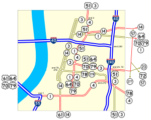 Map showing the west end of SR-1 in Memphis
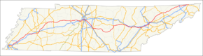
State Route 1 (SR-1), known as the Memphis to Bristol Highway, is a mostly-unsigned state highway in the U.S. state of Tennessee that is 538 miles (866 km) long. It stretches all the way from Memphis in the southwest corner of the state to Bristol in the northeast corner. Most of the route is overlaid on U.S. Highway 70 and U.S. Highway 11W.
SR-1 begins at Interstate 55 on the Tennessee end of the Memphis-Arkansas Bridge. U.S. Highway 61, U.S. Highway 64, U.S. Highway 70 and U.S. Highway 79 come off the bridge alongside SR-1; US-61 soon turns south with State Route 14. The other three U.S. Highways split east onto State Route 3, and U.S. Highway 51 joins, only to split with State Route 4 where SR-1 turns east alone onto North Parkway. However, US-64, US-70 and US-79 soon rejoin SR-1 at State Route 57. All of SR-1 through Memphis, except for the section on its own, is a primary route.
After leaving Memphis, SR-1 runs along the following routes:
- U.S. Highway 64, Memphis to State Route 15 in Bartlett
- U.S. Highway 79, Memphis to State Route 76 in Brownsville
- U.S. Highway 70, Memphis to State Route 22 Bypass in Huntingdon
- U.S. Highway 70 Business through Huntingdon
- U.S. Highway 70, State Route 364 in Huntingdon to State Route 24 west of Belle Meade
- U.S. Highway 70S through Belle Meade and Nashville to State Route 111 in Sparta
- Separate through Sparta - the only signed portion
- U.S. Highway 70, State Route 26 in Sparta to State Route 168 in Knoxville
- U.S. Highway 11W, Knoxville to Bristol
It is primary or secondary as follows:
- Primary, Memphis to State Route 76 in Brownsville
- Secondary, SR-76 to State Route 186 (U.S. Highway 45 Bypass) in Jackson
- Primary, SR-186 to State Route 22 Bypass in Huntingdon
- Secondary, SR-22 Bypass to State Route 364 in Huntingdon
- Primary, SR-364 to Interstate 40 west of Belle Meade
- Secondary, I-40 to State Route 100 in Belle Meade
- Primary, SR-100 to Interstate 440 in Nashville
- Secondary, I-440 to Interstate 24 in Nashville
- Primary, I-24 to State Route 111 in Sparta
- Secondary, SR-111 to State Route 26 in Sparta
- Primary, SR-26 to State Route 24 in Crossville
- Secondary, SR-24 to State Route 29 south of Rockwood
- Primary, SR-29 to State Route 61 in Rockwood
- Secondary, SR-61 to Interstate 40 in Knoxville
- Primary, I-40 to Bristol
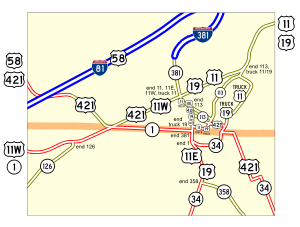 Map showing the east end of SR-1 in Bristol
In Bristol, SR-1 leaves U.S. Highway 11W right at the state line, and heads east on its own (as a primary route) along State Street. It turns south at U.S. Highway 11E/U.S. Highway 19, ending two blocks later at Broad Street (State Route 34).
Counties traversed (west to east)
State Route 1 traverses the counties shown in the table below.
Counties traversed by State Route 1 County miles kilometers Shelby 30.8 49.6 Fayette 7.9 12.7 Tipton 4.8 7.7 Haywood 28.1 45.3 Madison 32.1 51.6 Carroll 32.4 52.1 Benton 12.9 20.7 Humphreys 27.6 44.5 Dickson 21.9 35.2 Cheatham 9.4 15.1 Davidson 32.2 51.9 Rutherford 29.7 47.7 Cannon 14.9 24.0 Warren 24.4 39.3 Van Buren 2.9 4.6 White 22.2 35.7 Cumberland 34.2 55.0 Roane 28.0 45.0 Loudon 7.2 11.6 Knox 36.4 58.5 Grainger 31.4 50.5 Hawkins 41.4 66.6 Sullivan 25.4 40.8 References
- Tennessee Department of Transportation (24 January 2003). "State Highway and Interstate List 2003".
Categories:- State highways in Tennessee


Wikimedia Foundation. 2010.