- Clinch River
-
For the nuclear reactor, see Clinch River Breeder Reactor Project.
Clinch River 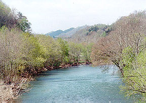
The Clinch River at Speers Ferry in Scott County, VirginiaOrigin Tazewell County, Virginia Mouth Tennessee River Basin countries USA Length 300 mi (483 km) Mouth elevation 741 ft (226 m) [1]  The Clinch drainage basin, located within the upper Tennessee drainage basin
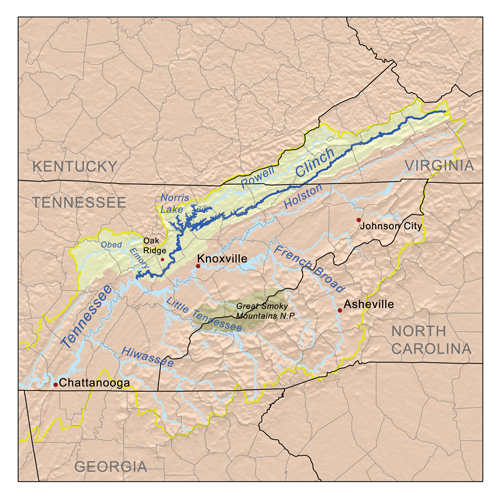
The Clinch River rises in Southwest Virginia near Tazewell, Virginia and flows southwest through the Great Appalachian Valley, gathering various tributaries including the Powell River before joining the Tennessee River in East Tennessee.
Contents
Course
The Clinch River is dammed twice: by Norris Dam, the first dam built by the Tennessee Valley Authority (TVA); and by Melton Hill Dam, the only TVA dam with a lock not located on the main channel of the Tennessee River. It empties into the Tennessee River at Kingston, Tennessee.
An important tributary of the Clinch River is the Powell River. The Clinch and Powell River drainage basins are separated by Powell Mountain. Tributaries entering the Clinch River below Norris Dam but above Melton Hill Dam include Coal Creek, Bull Run Creek, and Beaver Creek. Poplar Creek enters below Melton Hill Dam.
History
A peninsula located at the mouth of the Clinch River, called Southwest Point, was the site of an early frontier fort which has been recently reconstructed. The site was important to Native Americans. A treaty between the Cherokee and settlers was signed at Southwest Point, allowing the capital of Tennessee to be moved there. The Tennessee General Assembly technically fulfilled this requirement by meeting in Kingston for one day and voting to move the state capital elsewhere.
The river was once called "Clinch's River" and "Pelisipi River" (and variant spellings such as "Pelisippi" and "Pellissippi").[1] The name is said to mean "winding waters" in Cherokee (this claim is problematic; see Talk:Clinch River) and has been used in the area, such as Pellissippi Parkway and Pellissippi State Technical Community College.[2]
A huge coal-fired power plant sits on the Clinch River at Carbo in Russell County, Virginia; it was built in 1957 and is owned by Appalachian Power, a part of American Electric Power. On June 25, 2008, permits were approved by the state Air Pollution Control Board for another coal-fired power plant, a few miles away outside St. Paul, Virginia, by Dominion Virginia Power.
Pollution from mining in the region has caused great concern among environmentalists because several rare species inhabit the river. Some mussels have been reintroduced to the Cleveland, Virginia, area from outside the state the early 2000s after pollution in the 20th century wiped out much of the population.
In 2008 a massive release of fly ash from TVA's Kingston Fossil Plant deposited fly ash in the lower section of the river below the confluence of the Emory River.
Ecology
The Clinch River above Clinton, Tennessee (tailwaters of Norris Dam) is stocked with rainbow trout and brown trout by the Tennessee Wildlife Resources Agency.
Before being dammed, the Clinch River was a major producer of freshwater mussels and pearls. The rivers of the southern Appalachians are still notable for their unusually rich mussel biodiversity. The mussels were an important food source for Native Americans and were later used by settlers as bait and hog feed. The freshwater pearl industry thrived throughout the southern Appalachians in the late 19th century and early 20th century. The Clinch River and the Emory River were considered the economic heart of the pearl industry, and the state of Tennessee was one of the top six states in the United States for pearl production. The mussel-based industries began to decline in the early 20th century and were effectively eliminated by the dams built by the TVA. The first major Tennessee River dam was Wilson Dam, built at a site known as Muscle Shoals, referring to the freshwater mussels of the region. Norris Dam on the Clinch River flooded one of the other famous mussel areas near Young's Island. [3]
See also
References
- ^ a b U.S. Geological Survey Geographic Names Information System: Clinch River
- ^ Pellissippi State Technical Community College history
- ^ Davis, Donald Edward. "Where There Are Mountains, An Environmental History of the Southern Appalachians". University of Georgia Press: 2005.
External links
- Columbia Gazetteer of North America
- U.S. Geological Survey Geographic Names Information System: Clinch River
- Pellissippi Blueway
Coordinates: 35°51′48″N 84°31′55″W / 35.86333°N 84.53194°W
Categories:- Rivers of Tennessee
- Rivers of Virginia
- Tennessee River
- Geography of Anderson County, Tennessee
- Geography of Tazewell County, Virginia
- Geography of Russell County, Virginia
- Geography of Grainger County, Tennessee
Wikimedia Foundation. 2010.