- Monterey, Tennessee
-
Monterey, Tennessee — Town — Location of Monterey, Tennessee
Coordinates: 36°8′43″N 85°15′57″W / 36.14528°N 85.26583°WCoordinates: 36°8′43″N 85°15′57″W / 36.14528°N 85.26583°W Country United States State Tennessee County Putnam Area – Total 3.0 sq mi (7.7 km2) – Land 3.0 sq mi (7.6 km2) – Water 0.0 sq mi (0.0 km2) Elevation 1,883 ft (574 m) Population (2000) – Total 2,717 – Density 920.9/sq mi (355.6/km2) Time zone Central (CST) (UTC-6) – Summer (DST) CDT (UTC-5) ZIP code 38574 Area code(s) 931 FIPS code 47-49760[1] GNIS feature ID 1294185[2] Monterey is a town in Putnam County, Tennessee, United States. The population was 2,717 at the 2000 census. It is part of the Cookeville, Tennessee Micropolitan Statistical Area.
Contents
Geography
Monterey is located at 36°8′43″N 85°15′57″W / 36.14528°N 85.26583°W (36.145291, -85.265757)[3].
According to the United States Census Bureau, the town has a total area of 3.0 square miles (7.8 km2), of which, 3.0 square miles (7.8 km2) of it is land and 0.34% is water.
It is in Putnam County, Tennessee in the Cumberland Plateau area of middle Tennessee, approximately 90 miles (140 km) east of Nashville, Tennessee and the same distance west of Knoxville, Tennessee. It is accessible by road on Interstate 40, exits 300 and 301, US Highway 70, as well as state highways 62, 84 and 164.
History
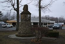 The Standing Stone Monument
Around the beginning of the twentieth century, Monterey was a resort town that boasted seven hotels and drew summer people who came to enjoy the cool temperatures and mountain scenery.
With the invention of the automobile, Monterey became less of a resort town. The hotels closed and the town's economy became dependent on railroad maintenance, coal mining, and logging.
The Standing Stone was a 13-foot (4.0 m)-tall rock that once stood upright on a sandstone ledge in the area. It was the legendary boundary between Cherokee and Shawnee territory and marked the Cherokee Tallonteeskee Trail. The 8-foot (2.4 m) remnant of this stone is preserved in Monterey, where a Standing Stone Celebration of Native American Heritage is held each October.
Demographics
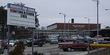 Monterey High School
As of the census[1] of 2000, there were 2,717 people, 1,029 households, and 697 families residing in the town. The population density was 920.9 people per square mile (355.6/km²). There were 1,141 housing units at an average density of 386.7 per square mile (149.3/km²). The racial makeup of the town was 88.81% White, 0.92% African American, 0.04% Native American, 0.18% Asian, 9.09% from other races, and 0.96% from two or more races. Hispanic or Latino of any race were 16.34% of the population.
There were 1,029 households out of which 31.4% had children under the age of 18 living with them, 50.0% were married couples living together, 12.9% had a female householder with no husband present, and 32.2% were non-families. 28.4% of all households were made up of individuals and 13.9% had someone living alone who was 65 years of age or older. The average household size was 2.54 and the average family size was 3.06.
In the town the population was spread out with 24.7% under the age of 18, 9.7% from 18 to 24, 26.8% from 25 to 44, 21.8% from 45 to 64, and 16.9% who were 65 years of age or older. The median age was 37 years. For every 100 females there were 95.0 males. For every 100 females age 18 and over, there were 89.1 males.
The median income for a household in the town was $23,550, and the median income for a family was $28,603. Males had a median income of $21,772 versus $18,895 for females. The per capita income for the town was $12,265. About 22.1% of families and 27.6% of the population were below the poverty line, including 38.4% of those under age 18 and 16.5% of those age 65 or over.
References
- ^ a b "American FactFinder". United States Census Bureau. http://factfinder.census.gov. Retrieved 2008-01-31.
- ^ "US Board on Geographic Names". United States Geological Survey. 2007-10-25. http://geonames.usgs.gov. Retrieved 2008-01-31.
- ^ "US Gazetteer files: 2010, 2000, and 1990". United States Census Bureau. 2011-02-12. http://www.census.gov/geo/www/gazetteer/gazette.html. Retrieved 2011-04-23.
External links
- Monterey High School
- Burks Middle School
- Uffelman Elementary School
- Monterey Branch Library
- Hilltop Express Newspaper
- Cookeville Gamers
Municipalities and communities of Putnam County, Tennessee City 
Towns Unincorporated
communitySilver Point
Categories:- Populated places in Putnam County, Tennessee
- Towns in Tennessee
- Cookeville micropolitan area


Wikimedia Foundation. 2010.