- Interstate 40 in North Carolina
-
This article is about the section of Interstate 40 in North Carolina. For the entire length of the highway, see Interstate 40.
Interstate 40
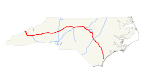
Route information Maintained by North Carolina DOT Length: 423.55 mi[1] (681.64 km) Existed: 1956-1990 – present Major junctions West end:  I-40 at Tennessee state line

 I-26 / I-240 / US 74 in Asheville
 I-240 / US 74A in Asheville
 I-77 in Statesville

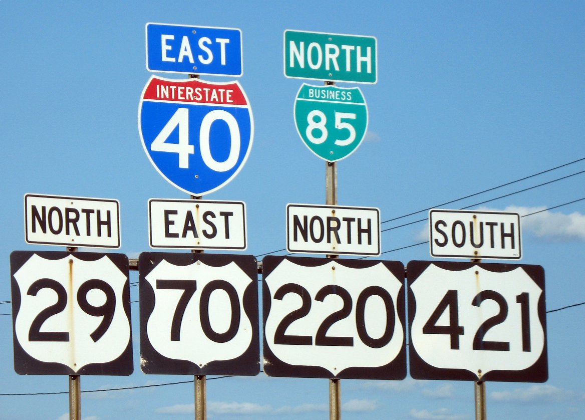
 I-73 / US 421 in Greensboro
 I-85 in Greensboro
I-85 near Chapel Hill
 I-540 in Durham


 I-440 / US 1 / US 64 in Raleigh
 I-95 near Benson

 I-140 / US 17 in Wilmington
East end: 
 US 117 / NC 132 in Wilmington
Location Counties: Haywood, Buncombe, McDowell, Burke, Catawba, Iredell, Davie, Forsyth, Guilford, Alamance, Orange, Durham, Wake, Johnston, Sampson, Duplin, Pender, New Hanover Highway system Main route of the Interstate Highway System
Main • Auxiliary • Business←  NC 39
NC 39NC 41  →
→Interstate 40 runs 421 miles (678 km) through the state of North Carolina from the Tennessee state line in the west to its eastern terminus in Wilmington. The middle segment of I-40 in the state is sometimes informally known as the "Tobacco Road" since it is the major thoroughfare linking the "Big Four" universities in the Tobacco Road sports rivalry.[2]
Contents
Route description
Pigeon River Gorge
The first section of I-40 in North Carolina is the section that travels through the Pigeon River Gorge in Haywood County. Known locally as simply "The Gorge", this part of I-40 cuts a path from the Tennessee state line to Waynesville. This section of the interstate is fairly curvy and tends to become a bit narrow in some places when compared to other portions of the highway. Because much of the road was cut through mountainside, concrete retaining walls have been built on both sides of the road and in the median, cutting down on the width of the breakdown lanes. Coupled with speeding vehicles, the extremely thick fog that tends to plague the area, and little room to maneuver in case of accident, this area has become notorious for its severe and many times fatal accidents. It is reported that a person is 20 times as likely to die on I-40 in Haywood County than they would be to win the Powerball lottery, which equals to be twice the average of any other Interstate Highway in North Carolina.[3]
Even some minor accidents have been known to tie up traffic in this area, because there is little room to move accidents off or to the side of the road with the terrain. Speeding semi trucks have been a problem in the gorge and have subsequently led to many accidents. In 2002 and 2003, two state troopers were killed in two separate accidents by speeding trucks that drifted off the road and hit their police car conducting a traffic stop. This led the North Carolina Highway Patrol to crack down on speeding tractor trailers and speeders in general through the area.
This portion of the highway is also notorious for rockslides and rocks falling onto the highway. The main cause is an engineering flaw, in that sections of the highway have been built on the north side of the Pigeon River, where the rock strata foliate towards the highway.
2009 rockslide and closure
On October 25, 2009, a major rockslide, including boulders described as the size of houses, blocked the highway completely at mile marker 2.6.[4] The section reopened with westbound traffic restricted to one lane on April 25, 2010.[5] Trucks wider than 12 feet are still prohibited through the slide area, and must still use the I-26 and I-81 detour.[6]
Through Greensboro
 The six routes of Death Valley in 2007. US 421 has since been rerouted; the shield was removed in 2009.
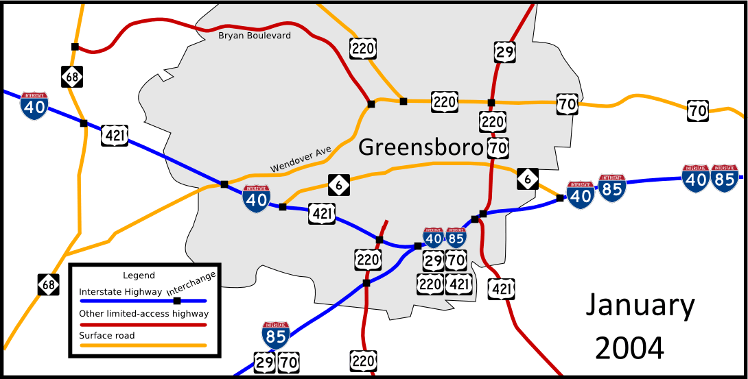
Throughout much of the Greensboro metropolitan area, I-40 follows a stretch of six-lane freeway carrying five other routes: Business I-85, U.S. Route 421, U.S. Route 29, U.S. Route 70, and U.S. Route 220. This 2.5-mile (4.0 km) corridor begins in the west at the I-40/Business I-85/Randleman Road interchange and ends in the east at the U.S. Highway 29/70/220/Martin Luther King Jr. Boulevard junction. Both of these interchanges are quite unusual in design and are often operating at above full capacity, leading to frequent traffic jams and traffic incidents.
I-40 through Greensboro officially bears the name Preddy Boulevard. The nickname "Death Valley" was originally given to the 2.5-mile (4.0 km) segment of I-85 in Greensboro in 1963 after seven people died in accidents there the previous year.[citation needed] In 1964, the state unveiled a plan to eliminate Death Valley's flaws.[citation needed] After numerous construction projects, conditions improved along the corridor, but the nickname remained. Over the years, increased traffic through the area has given the nickname "Death Valley" new meaning. The nickname is well-known by locals, news reporters, and frequent travelers.[citation needed]
One major problem with the highway is that the U.S. 29/220/70 southbound lanes merge from the right, and exit to the left. Thus, through traffic on I-40 west and US 29 south (a major route from Virginia to Charlotte) must all merge to the other side of the freeway. A study conducted by state traffic engineers from May 1, 2006 to April 30, 2008 (the period between the I-85 relocation and I-40's relocation) concluded that "the Death Valley area" had an accident rate "higher than average for urban interstates... but the [route] was safe anyway"[7] There were no fatalities during the study period, but a large number of rear-end collisions.[7]
Through The Triangle
I-40 through the Research Triangle varies in width, from 4 lanes to 8 lanes depending on the location. It serves as a major artery between Raleigh and Durham (the other being US-70). Work is in progress to widen the 4-lane stretch between Wade Avenue and US 1/I-440 through Cary which has been especially congested of late.[8][dated info]
I-40 is called Dan K. Moore Freeway from Durham to Wade Avenue and Tom Bradshaw Freeway through Raleigh. The James E. Harrington Freeway stretches to Newton Grove.
Eastern North Carolina
I-40 is 4 lanes from the western edge of Raleigh to Wilmington as it crosses through mostly agrarian land.
History
Construction
Construction on I-40 through North Carolina officially began in 1956 along the Pigeon River in Haywood County. This would be the first section of I-40 to be built anywhere in the country. This section was completed in 1968 and at that time contained the only Interstate Highway tunnels east of the Mississippi River. Construction continued through the 1950s and 1960s, with much of the interstate being constructed in the 1960s. The last portion of I-40 to be completed, between Raleigh and Wilmington was opened on June 29, 1990, by Governor James G. Martin. Much of Martin's election campaign in the mid-1980s was hinged on opening this section for the sake of improving access to the North Carolina State Port at Wilmington.[9]
A standard distance sign that once existed near the start of the westbound section of I-40 in Wilmington indicates the distance to Barstow, California as 2,554 miles (4,110 km). However, NCDOT has stated that it will not be replaced after frequent thefts.[10]
Rockslides in the Pigeon River Gorge
In 1985, a severe rockslide buried the westbound entrance to one of two tunnels that carry the highway through the gorge. Repair of the slide area and the tunnel required shifting westbound traffic to the eastbound tunnel, while eastbound traffic was diverted onto a temporary viaduct around the tunnels.
In July 1997, a rockslide near the Tennessee state line closed the road for nearly six months.[11]
On October 25, 2009, another rock slide occurred about 3 miles (4.8 km) from the Tennessee state line. The rock slide blocked both lanes of traffic and was estimated to be 100 feet long and up to 50 feet high.
Greensboro I-40 relocation
 Map showing changes made to I-40's routing between 2004 and 2008
In February 2008, Interstate 40 was rerouted onto the new Greensboro Urban Loop. The former path of I-40 became Business Loop I-40.[citation needed]
NCDOT received many complaints by local residents and motorists on the confusion between mainline Interstate 40 and Business 40, which used a shield differing only in color from the mainline I-40. Greensboro residents also had concerns with the resulting increased traffic. On September 12, 2008, seven months after the initial switch, NCDOT officials got permission from the FHWA to restore Interstate 40 back to its original route through the city, decommission Business Interstate 40, and leave I-73 and I-85 as the only interstates signed along the Loop. Exit numbers on the I-40 part of the Loop that ran with I-73 will be replaced with I-73 exit numbers from the I-85/US 220 southern interchange around the loop to the western I-40 interchange. US 421 was officially rerouted to replace most of I-40 around Greensboro.[12]
Work on re-signing the Loop and the former Business 40 began on May 8, 2009, with the exception of the eastern I-40/85 interchange, where signs were changed in the fall of 2008.[13][12] The re-signing project was completed on July 1, 2009.[14]
The current alignment of I-40 is four miles (6 km) shorter than the 2008 Urban Loop routing,[7] and is a quicker route for any vehicle consistently traveling at the posted speed limits.
Auxiliary routes in North Carolina
Interstate City Type Notes 
Business Interstate 40 Winston-Salem Business loop 
Interstate 140 Wilmington Spur 
Interstate 240 Asheville By-pass 
Interstate 440 Raleigh Beltway 
Interstate 540 Cary, Raleigh Beltway Partially constructed beltway 
Interstate 840 Greensboro Beltway Future, Under construction Exit list
County Location Exit Destinations Notes Haywood 7 Harmon Den 15 Fines Creek 20  US 276 south – Waynesville, Maggie Valley
24  NC 209 – Lake Junaluska, Hot Springs
27 
 US 19 / US 23 / US 74 west – Clyde, Waynesville
West end of US 74 overlap Canton 31  NC 215 – Canton
33 Newfound Road Buncombe 37 Candler, East Canton Asheville 44 US 19 / US 23 – West Asheville, Enka, Candler46A I-26 east / US 74 east – Hendersonville, Spartanburg, Asheville AirportEastbound exit and westbound entrance 46B I-26 west / I-240 west – Asheville47  NC 191 – West Asheville, Farmers Market
50  US 25 – South Asheville, Biltmore House
Signed as exits 50A (south) and 50B (north) westbound 51 
US 25 Alt. – Asheville53A
US 74 Alt. east / Blue Ridge Parkway – Bat Cave53B 
I-240 west / US 74 Alt. west – East Asheville55  To US 70 – East Asheville, VA Hospital
59 Swannanoa Black Mountain 64  NC 9 – Black Mountain, Montreat
65 US 70 west – Black MountainWest end of US 70 overlap; westbound exit and eastbound entrance 66 Ridgecrest McDowell Old Fort 72 US 70 east – Old FortEast end of US 70 overlap; eastbound exit and westbound entrance 73 Old Fort 75 Parker Padgett Road Marion 81 Sugar Hill Road – Marion 83 Ashworth Road 85  US 221 – Marion, Rutherfordton
86  NC 226 – Marion, Shelby
90 Nebo, Lake James Burke 94 Dysartsville Road 96 Kathy Road 98 Causby Road – Glen Alpine Glen Alpine 100 Jamestown Road, Dixie Boulevard – Glen Alpine Morganton 103 US 64 – Morganton, Rutherfordton104 Enola Road 105  NC 18 – Morganton, Shelby
106 Bethel Road 107  NC 114 – Drexel
111 Valdese Valdese 112 Mineral Springs Mountain Road – Valdese Rutherford College 113 Rutherford College, Connelly Springs Icard 116 Icard Hildebran 118 Old NC 10 119 Henry River, Hildebran Signed as exits 119A (Henry River) and 119B (Hildebran) eastbound Catawba Long View 121 Long View Hickory 123 
 US 321 to US 70 / NC 127 – Lincolnton, Lenoir
Signed as exits 123A (south) and 123B (north) 125 Hickory, Lenior Rhyne College 126 To US 70 – Hickory, Newton128 Fairgrove Church Road, Hickory Motor Speedway The Exit is in the City of Conover Conover 130 US 70Farmers Market, K-Mart132  NC 16 – Conover, Taylorsville, Newton, Wal-Mart
133 Rock Barn Road, Rock Barn Golf And Spa Claremont 135 Claremont Catawba 138  NC 10 west (Oxford School Road) – Catawba
Iredell 141 Sharon School Road 144 Old Mountain Road, West Iredell 146 Stamey Farm Road Statesville 148  US 64 / NC 90 – West Statesville, Taylorsville
150  NC 115 – Downtown Statesville, North Wilkesboro
151  US 21 – East Statesville, Harmony
152 I-77 – Charlotte, ElkinSigned as exits 152A (south) and 152B (north) 153 US 64Eastbound exit and westbound entrance 154 US 64 (Old Mocksville Road)162 US 64Davie 168 US 64 – MocksvilleMocksville 170  US 601 – Mocksville, Yadkinville
174 Farmington Road 180  NC 801 – Bermuda Run, Tanglewood
Forsyth Clemmons 182 Tanglewood, Bermuda Run 184 Lewisville, Clemmons Winston-Salem 188  I-40 Bus. east / US 421 – Downtown Winston-Salem, Yadkinville, Wilkesboro
No access from I-40 east to US-421 south 189  US 158 (Stratford Road)
190 Hanes Mall Boulevard Westbound exit and eastbound entrance 192  NC 150 (Peters Creek Parkway) – Downtown Winston-Salem
193C Silas Creek Parkway, South Main Street Westbound exit and eastbound entrance 193 

 US 52 / NC 8 / US 311 north – Lexington, Mount Airy
West end of US 311 overlap; signed as exits 193A (south) and 193B (north) 195  NC 109 / Clemmonsville Road – Thomasville
196 US 311 south – High PointEast end of US 311 overlap Kernersville 201 Union Cross Road 203  NC 66 / Regional Road – Kernersville, High Point
Guilford 206 I-40 Bus. north / US 421 – Kernersville, Downtown Winston-SalemWest end of US 421 overlap; westbound exit and eastbound entrance Greensboro 208 Sandy Ridge Road 210  NC 68 – High Point, Piedmont Triad International Airport
211 Gallimore Dairy Road 212 I-73 / US 421 south / To Bryan Boulevard (via I-840 and I-73 north) – Asheboro, PTI AirportEast end of US 421 overlap; signed as exits 212A (Bryan Boulevard) and 212B (I-73/US 421) 213 Guilford College Road 214 Wendover Avenue Signed as exits 214A (east) and 214B (west) eastbound 216  NC 6 (Patterson Street)
Eastbound exit and westbound entrance 217 High Point Road, Koury Boulevard 218 
 US 220 south to I-85 Bus. south / Freeman Mill Road – Asheboro
West end of US 220 overlap; signed as exits 218A (US 220) and 218B (Freeman Mill Road) 219  I-85 Bus. south / US 29 south / US 70 west – Charlotte
West end of US 29/US 70/I-85 Bus. overlap 220 Randleman Road 221 South Elm-Eugene Street – Downtown Greensboro 222 Martin Luther King Jr. Drive 223 US 29 north / US 70 east / US 220 north – ReidsvilleEast end of US 29/US 70/US 220 overlap; northbound exit and southbound entrance 224 To NC 6 north (East Lee Street) / US 29 north / US 220South end of US 29/US 70/US 220 overlap 226 McConnell Road 227  To US 70 / I-840 north
228 I-85 south – CharlotteWestbound exit and eastbound entrance I-40 overlaps with Interstate 85 (exits 131 to 163) Orange 259 I-85 north – DurhamEast end of I-85 overlap 261 Hillsborough 263 New Hope Church Road 266  NC 86 – Chapel Hill
Durham Chapel Hill 270 
 US 15-501 – Chapel Hill, Durham
Signed as exits 270A (south) and 270B (north) 273  NC 54 – Chapel Hill, Durham
Signed as exits 273A (west) and 273B (east) westbound Durham 274  NC 751 – Jordan Lake
276 Fayetteville Road – Southpoint, North Carolina Central University 278  NC 55 to NC 54 – Apex
279A Alexander Drive 279B  NC 147 north (Durham Freeway) – Downtown Durham
280 Davis Drive 281 Miami Boulevard 282 Page Road 283  I-540 east / NC 540 west to US 70 / NC 55 – Apex
Signed as exits 283A (west) and 283B (north) westbound Wake Morrisville 284 Airport Boulevard – RDU International Airport Signed as exits 284A (west) and 284B (east) eastbound 285 Aviation Parkway – Morrisville, RDU International Airport Cary 287 Harrison Avenue – Cary 289 To I-440 / US 1 north / Wade Avenue – Downtown Raleigh290 NC 54 – Cary291 Cary Towne Boulevard – Cary Raleigh 293 I-440 east / US 1 / US 64 west – Cary, Asheboro, Wake Forest, RaleighWest end of US 64 overlap; signed as exits 293A (south/west) and 293B (north/east) 295 Gorman Street 297 Lake Wheeler Road 298 
 US 70 east / US 401 south / NC 50 south (South Saunders Street) – Fayetteville, Downtown Raleigh, Garner
Signed as exits 298A (east/south) and 298B (west/north) 299 Hammond Road, Person Street 300 Rock Quarry Road Signed as exits 300A (south) and 300B (north) westbound 301 I-440 west / US 64 east – Rocky MountEast end of US 64 overlap 303 Jones Sausage Road Garner 306 

US 70 west / US 70 Bus. east – Garner, ClaytonWest end of US 70 overlap; signed as exits 306A (west) and 306B (east) westbound 309 US 70 east – Smithfield, GoldsboroEast end of US 70 overlap Johnston 312  NC 42 – Clayton, Fuquay-Varina
319  NC 210 – Smithfield, Angier
325 
 NC 242 to US 301 – Benson
328 I-95 – Fayetteville, Rocky MountSigned as exits 328A (south) and 328B (north) 334  NC 96 – Peacocks Crossroads
Sampson 341 NC 50 / NC 55 – Newton Grove, Dunn343  US 701 – Clinton, Newton Grove
348 Suttontown Road 355  NC 403 – Faison
Duplin 364
 NC 24 west / NC 24 Bus. east to NC 50 – Warsaw, Clinton
West end of NC 24 overlap 369 US 117 – Warsaw, Magnolia373  NC 24 east / NC 903 – Magnolia, Kenansville
East end of NC 24 overlap 380 Rose Hill 384  NC 11 – Teachey, Wallace, Kenansville
385 NC 41 – Wallace, BeulavillePender 390 US 117 – Wallace, Burgaw398  NC 53 – Burgaw, Jacksonville
408 NC 210 – Hampstead, Topsail IslandNew Hanover Castle Hayne 414 Holly Shelter Road – Castle Hayne 416 I-140 / US 17 – New Bern, Topsail Island, Shallotte, Myrtle BeachSigned as exits 416A (west/south) and 416B (east/north) Wilmington 420 US 117 north / NC 132 north / Gordon RoadSigned as exits 420A (Gordon Road) and 420B (US 117/NC 132) westbound US 117 south / NC 132 southEastbound exit and westbound entrance 1.000 mi = 1.609 km; 1.000 km = 0.621 mi
Concurrency terminus • Closed/Former • Incomplete access • UnopenedReferences
- ^ Route Log - Main Routes of the Eisenhower National System Of Interstate and Defense Highways - Table 1
- ^ ABC Local "What is Tobacco Road?"
- ^ The Smoky Mountain News
- ^ [1][dead link]
- ^ Hickman, Hayes. "Section of I-40 closed since Oct. rockslide reopens » Knoxville News Sentinel". Knoxnews.com. http://www.knoxnews.com/news/2010/apr/25/section-of-i-40-back-open-after-oct-slide/. Retrieved 2011-09-19.
- ^ "Travel Information". NCDOT. http://www.ncdot.org/traffictravel/. Retrieved 2011-09-19.
- ^ a b c "Which Way Do We Go?" Winston-Salem Journal. Sunday, February 1, 2009 issue. Page 1 Section A.
- ^ "I-40 Widening Project & I-440 Signing Improvements". NC DOT. http://www.ncdot.gov/projects/I4744/. Retrieved 25 August 2010.
- ^ Steelman, Ben (2010-06-28). "Decades of effort put into 122-mile, $417 million stretch of I-40". Star-News. http://www.starnewsonline.com/article/20100628/ARTICLES/100629689. Retrieved 2010-06-29.
- ^ "Popular I-40 sign stolen again". News & Observer. http://www.newsobserver.com/news/local_state/story/189822.html. Retrieved November 13, 2009.[dead link]
- ^ http://www.dem.dcc.state.nc.us/PIO/97report.PDF
- ^ a b NCDOT Press Release Dated 9/12/08
- ^ Greensboro Urban Loop on Flickr
- ^ News 14 Carolina. "Signing Changes Coming to I-40". Report aired May 11, 2009.
External links
- News & Record: New roads, old worries (Aug 26, 2007)
- News & Record - Nation's interstates turn 50
- Gribblenation - Greensboro Bypass Photos
- NCDOT article on the I-40 relocation (Sept 12, 2008)
Interstate 40Previous state:
TennesseeNorth Carolina Next state:
TerminusInterstate Highways in North Carolina Current Future Business Categories:- Interstate Highways in North Carolina
- Interstate 40
- Research Triangle, North Carolina
- Transportation in Haywood County, North Carolina
- Transportation in Buncombe County, North Carolina
- Transportation in McDowell County, North Carolina
- Transportation in Burke County, North Carolina
- Transportation in Catawba County, North Carolina
- Transportation in Iredell County, North Carolina
- Transportation in Davie County, North Carolina
- Transportation in Forsyth County, North Carolina
- Transportation in Guilford County, North Carolina
- Transportation in Alamance County, North Carolina
- Transportation in Orange County, North Carolina
- Transportation in Durham County, North Carolina
- Transportation in Wake County, North Carolina
- Transportation in Johnston County, North Carolina
- Transportation in Sampson County, North Carolina
- Transportation in Duplin County, North Carolina
- Transportation in Pender County, North Carolina
- Transportation in New Hanover County, North Carolina


Wikimedia Foundation. 2010.