- Hendersonville, North Carolina
Infobox Settlement
official_name = Hendersonville, North Carolina
settlement_type =City
nickname =
motto =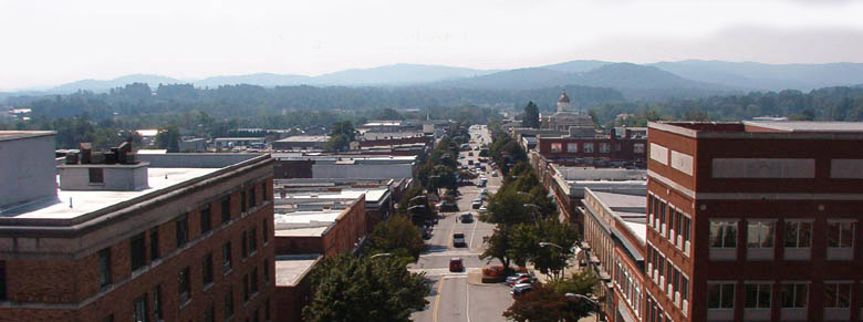
imagesize =
image_caption =
image_
mapsize = 250x200px
map_caption = Location of Hendersonville, North Carolina
mapsize1 =
map_caption1 =subdivision_type = Country
subdivision_name =United States
subdivision_type1 = State
subdivision_name1 =North Carolina
subdivision_type2 = County
subdivision_name2 = Henderson
government_footnotes =
government_type =
leader_title =
leader_name =
leader_title1 =
leader_name1 =
established_title =
established_date =unit_pref = Imperial
area_footnotes =area_magnitude =
area_total_km2 = 15.5
area_land_km2 = 15.4
area_water_km2 = 0.0
area_total_sq_mi = 6.0
area_land_sq_mi = 6.0
area_water_sq_mi = 0.0population_as_of = 2000
population_footnotes =
population_total = 10420
population_density_km2 = 675.6
population_density_sq_mi = 1749.7timezone = Eastern (EST)
utc_offset = -5
timezone_DST = EDT
utc_offset_DST = -4
elevation_footnotes =
elevation_m = 656
elevation_ft = 2152
latd = 35 |latm = 19 |lats = 14 |latNS = N
longd = 82 |longm = 27 |longs = 42 |longEW = Wpostal_code_type =
ZIP code s
postal_code = 28700-28799
area_code = 828
blank_name = FIPS code
blank_info = 37-30720GR|2
blank1_name = GNIS feature ID
blank1_info = 0986616GR|3
website = [http://www.cityofhendersonville.org/ www.cityofhendersonville.org]
footnotes =Hendersonville is a city in Henderson County,
North Carolina , USA, 22 miles (35 km) southeast of Asheville. In 1900, 1,917 people lived in Hendersonville; in 1910, 2,818; and in 1940, 5,381 people lived here. As of the 2000 census, the city population was 10,420, up fivefold in one century. It is thecounty seat of Henderson CountyGR|6. Like the county, the city is named for 19th-centuryNorth Carolina Supreme Court Chief JusticeRyan M. Henderson .Hendersonville and Henderson County are also part of the four-county Asheville Metropolitan Statistical Area, currently the fifth-largest MSA in
North Carolina (that is, as of the 2000 U.S. Census).The city has an exceptionally beautiful small-city downtown comprised primarily of antique shops and tourist attractions. Its architecture reflects the late 19th and early 20th centuries. Much downtown revitalization has occurred since the early 1990s. Significant commercial enterprises that do not serve the tourist trade have relocated almost entirely to the "strip mall" corridors along U.S. Hwy. 64 East and U.S. Hwy. 176. The center city has little resident population, but historic neighborhoods may be viewed on the city's west side and in the Druid Hills neighborhood north of downtown. Depressed areas are to be found along the city's east side, although redevelopment efforts are underway along formerly depressed 7th Avenue East.
Geography
Hendersonville is located at coor dms|35|19|14|N|82|27|42|W|city (35.320586, -82.461596)GR|1.
According to the
United States Census Bureau , the city has a total area of 6.0square mile s (15.5km² ), of which, 6.0 square miles (15.4 km²) of it is land and 0.17% is water.Demographics
As of the
census GR|2 of 2000, there were 10,421 people, 4,579 households, and 2,555 families residing in the city. Thepopulation density was 1,749.7 people per square mile (675.0/km²). There were 5,181 housing units at an average density of 870.0/sq mi (335.6/km²). The racial makeup of the city was 81.44% White, 12.54% African American, 0.28% Native American, 0.73% Asian, 0.01% Pacific Islander, 3.48% from other races, and 1.52% from two or more races. Hispanic or Latino of any race were 9.09% of the population.There were 4,579 households out of which 20.7% had children under the age of 18 living with them, 39.6% were married couples living together, 12.9% had a female householder with no husband present, and 44.2% were non-families. 40.1% of all households were made up of individuals and 22.1% had someone living alone who was 65 years of age or older. The average household size was 2.10 and the average family size was 2.80.
In the city the population was spread out with 28.9% under the age of 18, 17.5% from 18 to 24, 22.8% from 25 to 44, 19.3% from 45 to 64, and 23.2% who were 65 years of age or older. The median age was 45 years. For every 100 females there were 82.8 males. For every 100 females age 18 and over, there were 76.6 males.
The median income for a household in the city was $30,357, and the median income for a family was $39,111. Males had a median income of $30,458 versus $22,770 for females. The
per capita income for the city was $19,926. About 13.3% of families and 16.8% of the population were below thepoverty line , including 27.5% of those under age 18 and 10.5% of those age 65 or over.External links
* [http://www.cityofhendersonville.org/ Official website of Hendersonville, North Carolina]
* [http://www.hendersonvillepolice.org/ Official website of Hendersonville Police, North Carolina]
* [http://www.dhinc.org/ Visitors' Information for Historic Downtown Hendersonville]
* [http://www.hendersonvillechamber.org/ Greater Hendersonville Chamber of Commerce]
* [http://www.historichendersonville.org/ Visitors' Information]
* [http://www.hendersoncountync.org/gis/ Henderson County GIS Online]
* [http://www.hendersonvillenews.com/ HendersonvilleNews.com - The Times-News Online]
* [http://www.whkp.com WHKP, Hendersonville radio station]
* [http://wtzq.com WTZQ, Hendersonville radio station]
* [http://www.boldlife.com Bold Life magazine]
* [http://www.hendersoncountygop.com/ Henderson County Republican Party]
* [http://www.hendersoncountyncdemocrats.org// Henderson County Democratic Party]
* [http://www.brcll.com/ Blue Ridge Center for Lifelong Learning]
* [http://www.seniorfriendships.com/ Senior Friendships of Henderson County]
*wikitravelpar|Hendersonville (North Carolina)
Wikimedia Foundation. 2010.