- Henderson, North Carolina
-
For the city in Henderson County, North Carolina, in the western part of the state, see Hendersonville, North Carolina.
Henderson, North Carolina — City — Historic downtown Henderson

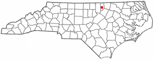
SealNickname(s): The Gateway City, Triangle North, The Gate's Motto: Progress, Pride, Potential Location of Henderson, North Carolina
Coordinates: 36°19′29″N 78°24′31″W / 36.32472°N 78.40861°WCoordinates: 36°19′29″N 78°24′31″W / 36.32472°N 78.40861°W Country United States State North Carolina County Vance Government – Type Municipality – Mayor James D. Pete O'Geary Area – Total 8.3 sq mi (21.4 km2) – Land 8.2 sq mi (21.3 km2) – Water 0.0 sq mi (0.0 km2) Elevation 505 ft (154 m) Population (2000) – Total 16,095 – Density 1,953.7/sq mi (754.3/km2) Time zone Eastern (EST) (UTC-5) – Summer (DST) EDT (UTC-4) ZIP codes 27536-27537 Area code(s) 252 FIPS code 37-30660[1] GNIS feature ID 0986608[2] Website www.ci.henderson.nc.us Henderson, with a population of 16,095 at the 2000 census, is the county seat of Vance County, North Carolina, United States.[3]
The city was named in honor of former North Carolina Supreme Court Chief Justice Leonard Henderson, who lived nearby and was a friend of early settler Lewis Reavis. Henderson was officially chartered by the North Carolina General Assembly in 1841.
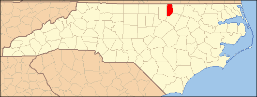
Prior to the creation of Vance County in 1881, Henderson was located in far eastern Granville County.[4]
Contents
Geography
Henderson is located at 36°19′29″N 78°24′31″W / 36.32472°N 78.40861°W (36.324753, -78.408536)[5].
According to the United States Census Bureau, the city has a total area of 8.2 square miles (21 km2), of which, 8.2 square miles (21 km2) of it is land and 0.12% is water.
Henderson benefits from its location near Interstate 85 and U.S. 1. Highway 39 also runs through Henderson.
Demographics
As of the census[1] of 2000, there were 16,095 people, 6,332 households, and 4,122 families residing in the city. The population density was 1,953.7 people per square mile (754.2/km²). There were 6,870 housing units at an average density of 833.9 per square mile (321.9/km²). The racial makeup of the city was 59.17% African American , 36.76% White,, 0.27% Native American, 0.64% Asian, 0.02% Pacific Islander, 2.36% from other races, and 0.77% from two or more races. Hispanic or Latino of any race were 5.13% of the population.
There were 6,332 households out of which 31.3% had children under the age of 18 living with them, 34.1% were married couples living together, 26.7% had a female householder with no husband present, and 34.9% were non-families. 30.7% of all households were made up of individuals and 14.4% had someone living alone who was 65 years of age or older. The average household size was 2.47 and the average family size was 3.05.
In the city the population was spread out with 27.4% under the age of 18, 8.9% from 18 to 24, 26.8% from 25 to 44, 20.6% from 45 to 64, and 16.4% who were 65 years of age or older. The median age was 36 years. For every 100 females there were 82.2 males. For every 100 females age 18 and over, there were 75.5 males.
The median income for a household in the city was $23,745, and the median income for a family was $30,222. Males had a median income of $26,804 versus $19,910 for females. The per capita income for the city was $15,130. About 23.4% of families and 28.3% of the population were below the poverty line, including 40.5% of those under age 18 and 20.9% of those age 65 or over.
Notable people
- Charlie Rose, American television talk show host and journalist, was born and raised in Henderson
- Gerald Alston, member of R&B vocal group The Manhattans[citation needed]
- Doug Roberson, British television talk show host and riverboat gambler
- Jason Brown, Center for the St. Louis Rams, an American football team
- Elson Floyd, educator and 10th president of Washington State University
- Ben E. King, American soul and pop singer best known as the singer and co-composer of "Stand by Me"
References
- ^ a b "American FactFinder". United States Census Bureau. http://factfinder.census.gov. Retrieved 2008-01-31.
- ^ "US Board on Geographic Names". United States Geological Survey. 2007-10-25. http://geonames.usgs.gov. Retrieved 2008-01-31.
- ^ "Find a County". National Association of Counties. http://www.naco.org/Counties/Pages/FindACounty.aspx. Retrieved 2011-06-07.
- ^ http://cartweb.geography.ua.edu:9001/StyleServer/calcrgn?cat=North%20America%20and%20United%20States&item=States/North%20Carolina/NorthCarolina1876a.sid&wid=500&hei=400&props=item(Name,Description),cat(Name,Description)&style=simple/view-dhtml.xsl
- ^ "US Gazetteer files: 2010, 2000, and 1990". United States Census Bureau. 2011-02-12. http://www.census.gov/geo/www/gazetteer/gazette.html. Retrieved 2011-04-23.
External links
- Official website of Henderson, North Carolina
- Henderson-Vance Chamber of Commerce
- "The Daily Dispatch" - local newspaper
- "Home in Henderson" - local news blog
- Life in Henderson in the 1920s
- Vance County History & Genealogy
Municipalities and communities of Vance County, North Carolina County seat: HendersonCity Henderson

Towns CDP Unincorporated
communityCategories:- Cities in North Carolina
- Populated places in Vance County, North Carolina
- County seats in North Carolina
- Populated places in North Carolina with African American majority populations
Wikimedia Foundation. 2010.