- Inner Banks
-
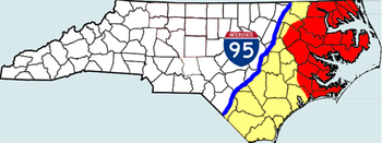
The Inner Banks is a term used by some to describe the inland coastal region of eastern North Carolina, an area on the East Coast of the United States that is 22,227 square-miles (57,568-km².) by its broadest definition. This coastal region was branded the Inner Banks to distinguish it from the Outer Banks, a string of small islands off the coast of North Carolina that are a popular tourist attraction. Together both "banks" roughly form the Coastal Plains region.
The Inner Banks comprises over 3,000 miles of inland coastline and is home to over 2.5 million residents. The Crystal Coast and Albemarle regions of the state are typically included in the Inner Banks. With a moderate climate, the area is becoming a popular destination for retirees and small business entrepreneurs.[1][2] "Inner Banks" is sometimes abbreviated with the acronym IBX. The term "Inner Banks" is a recent construct on the part of developers and the tourism industry to rebrand the mostly agrarian coastal plain as a more attractive region for visitors and retirees. The term is rarely used colloquially[citation needed]. Many long-time residents are resisting the adoption of the term to describe the area since it's perceived as little more than a marketing tool with a scant history behind it.
The general definition states that the Inner Banks lie between Interstate 95 to the west, the Outer Banks to the east, and extend from the Virginia border down to the South Carolina border. Consisting of 41 counties, the region is three times the size of the state of New Jersey. Many areas farther from the sounds and tidal rivers have not embraced the Inner Banks brand and are seldom included in the definition. Traditionally dependent on agriculture and the textile industry, eastern North Carolina is undergoing an economic evolution by redefining the region's strengths to transition into the new global economy.
Six small towns in the Inner Banks have joined together in the Creative Communities Initiative. [1] They are working to strengthen the region’s economy by fostering an environment attractive to knowledge workers, artists, and other people working in the creative economy. The six towns involved in the project are: Ayden, NC; Edenton, NC; Hertford, NC; Murfreesboro, NC; Plymouth, NC; and Tarboro, NC.
Contents
Albemarle Region
Northeastern North Carolina (or the Albemarle Region) consists of 16 counties in extreme northeast North Carolina that surround Albemarle Sound and its tributaries, such as the Chowan River and the Roanoke River. Although the region has historically lagged behind the rest of North Carolina in terms of economic growth, it has numerous attractions in its undeveloped beaches, rivers, and small towns. The area comprises the northern part of the Inner Banks.
History
Given its access to the sound and rivers, the area was inhabited for thousands of years by various indigenous peoples.
After European contact, the area which is now northeastern North Carolina and southeastern Virginia was one of the first in North America to be settled by Europeans. Virginia Dare, the first English child born in North America, was born on nearby Roanoke Island in 1587, in what is today part of North Carolina.
The Low Country was devoted to tobacco and cotton cultivation, and planters imported thousands of enslaved Africans for their work force. They and their descendants were integral to the survival and success of the North Carolina colony and later state. Tobacco was especially labor intensive and exhausted the soil. Some of the first planters shifted to mixed farming by the end of the 18th century.
Most of the region was relatively prosperous until the American Civil War, when its productive farmland and shipping industries became a frequent target for Union invasions. Several towns in the region were burned to the ground by Union troops during this time, including Plymouth and Winton. Confederate forces at Plymouth made the first use of an ironclad warship. the CSS Albemarle.
After the war, agriculture suffered across the South, and the region was slow to change its economy.
Area
Counties
The following is a list of counties usually considered a part of the Inner Banks (listed alphabetically):
Generally:
- Beaufort County
- Bertie County
- Camden County
- Carteret County
- Chowan County
- Craven County
- mainland Currituck County
- mainland Dare County
- eastern Edgecombe County
- Gates County
- Hertford County
- eastern Halifax
- mainland Hyde County
- eastern Jones County
- Martin County
- eastern Onslow County
- Pamlico County
- Pasquotank County
- Perquimans County
- Pitt County
- Tyrrell County
- Washington County
Cities and towns
The following is a list of some of the towns and communities in the Inner Banks (listed alphabetically):
- Ahoskie
- Ayden
- Arapahoe
- Aurora
- Bath
- Bayboro
- Beaufort
- Belhaven
- Bethel
- Camden
- Chocowinity
- Columbia
- Corapeake
- Creswell
- Currituck
- Edenton
- Elizabeth City
- Eure
- Eureka
- Farmville
- Fremont
- Gates
- Gatesville
- Greenville
- Goldsboro
- Grifton
- Hampstead
- Harkers Island
- Havelock
- Hertford
- Hobbsville
- Jacksonville
- Knotts Island
- Morehead City
- Moyock
- Murfreesboro
- New Bern
- Oriental
- Pantego
- Plymouth
- Robersonville
- Roducco
- Roper
- Stantonsburg
- Sunbury
- Swan Quarter
- Swansboro
- Tarboro
- Trenton
- Vanceboro
- Washington
- Williamston
- Windsor
- Winton
Parks
Wildlife refuges
- Alligator River National Wildlife Refuge
- Cedar Island National Wildlife Refuge
- Great Dismal Swamp National Wildlife Refuge
- Mattamuskeet National Wildlife Refuge
- Pocosin Lakes National Wildlife Refuge
- Roanoke River National Wildlife Refuge
- Swanquarter National Wildlife Refuge
Colleges and universities
.
- Beaufort County Community College
- Carteret Community College
- Coastal Carolina Community College
- College of the Albemarle
- Craven Community College
- Edgecombe Community College
- Halifax Community College
- Martin Community College
- Pamlico Community College
- Pitt Community College
- Roanoke-Chowan Community College
See also
- Tidewater
- Crystal Coast
- Southeastern North Carolina
- Intracoastal Waterway
- Outer Banks
- Atlantic Coastal Plain
References
- ^ "Series: The New Waterfront". News and Observer. July 31, 2006. http://www.newsobserver.com/1233/.
- ^ "Carolina's Inner Sanctum". Tampa Tribune. October 15, 2006. http://www.venture-east.com/IBX%20Newsletter/Carolinas%20Inner%20Sanctum.pdf.
External links
Inner Banks
- The IBX Newsletter
- IBX Lifestyles
- IBX Arts, a not-for-profit art organization, based in Columbia, NC
- Cruising Carolina
- Inner Banks Film
.
.
- City of Greenville
- Elizabeth City Area Convention & Visitors Bureau
- Elizabeth City Area CVB's Blog
- Inner Banks of Washington NC Tourism
- Town of Belhaven
- Columbia, NC
- SwanQuarter, NC
.
Albermarle Region
Categories:- Regions of North Carolina
Wikimedia Foundation. 2010.


