- Craven County, North Carolina
-
Craven County, North Carolina 
Seal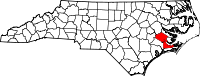
Location in the state of North Carolina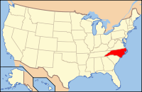
North Carolina's location in the U.S.Founded 1712 Seat New Bern Area
- Total
- Land
- Water
774 sq mi (2,005 km²)
708 sq mi (1,834 km²)
66 sq mi (171 km²), 8.49%PopulationEst.
- (2006)
- Density
94,875
129/sq mi (50/km²)Website www.cravencounty.com Craven County is a county located in the U.S. state of North Carolina. The estimated population in 2006 was 94,875.[1] Its county seat is New Bern[1].
Craven County is part of the New Bern, North Carolina, Micropolitan Statistical Area.
Contents
History
Craven County was named for William, Earl of Craven, who lived from 1606-1697. The county was created from the now-extinct Bath County in 1712.[2]
Geography
According to the U.S. Census Bureau, the county has a total area of 774 square miles (2,004.7 km2), of which 708 square miles (1,833.7 km2) is land and 66 square miles (170.9 km2) (8.49%) is water.
Adjacent counties
- Beaufort County (northeast)
- Pamlico County (east)
- Carteret County (southeast)
- Jones County (southwest)
- Lenoir County (west)
- Pitt County (northwest)
National protected area
- Croatan National Forest (part)
Law and government
Craven County is a member of the regional Eastern Carolina Council of Governments.
Demographics
As of the census[3] of 2000, there were 91,436 people, 34,582 households, and 25,071 families residing in the county. The population density was 129 people per square mile (50/km²). There were 38,150 housing units at an average density of 54 per square mile (21/km²). The racial makeup of the county was 69.94% White, 25.12% Black or African American, 0.42% Native American, 0.99% Asian, 0.06% Pacific Islander, 1.78% from other races, and 1.68% from two or more races. 4.02% of the population were Hispanic or Latino of any race.
There were 34,582 households out of which 33.30% had children under the age of 18 living with them, 56.80% were married couples living together, 12.50% had a female householder with no husband present, and 27.50% were non-families. 23.40% of all households were made up of individuals and 8.90% had someone living alone who was 65 years of age or older. The average household size was 2.50 and the average family size was 2.93.
In the county the population was spread out with 24.60% under the age of 18, 12.80% from 18 to 24, 27.90% from 25 to 44, 21.20% from 45 to 64, and 13.40% who were 65 years of age or older. The median age was 34 years. For every 100 females there were 101.90 males. For every 100 females age 18 and over, there were 101.50 males.
The median income for a household in the county was $35,966, and the median income for a family was $42,574. Males had a median income of $28,163 versus $21,412 for females. The per capita income for the county was $18,423. About 9.90% of families and 13.10% of the population were below the poverty line, including 18.50% of those under age 18 and 11.00% of those age 65 or over.
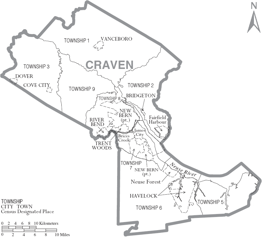
Cities and towns
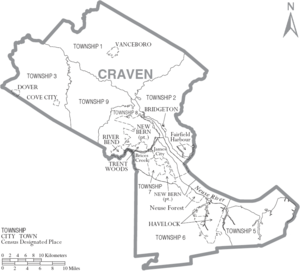 Map of Craven County, North Carolina With Municipal and Township Labels
- Brices Creek
- Bridgeton
- Cove City
- Dover
- Fairfield Harbour
- Havelock
- James City
- Neuse Forest
- New Bern
- River Bend
- Trent Woods
- Vanceboro
- Harlowe
- Cherry Point
- Cherry Branch
- Adams Creek
See also
References
- ^ "Find a County". National Association of Counties. http://www.naco.org/Counties/Pages/FindACounty.aspx. Retrieved 2011-06-07.
- ^ Craven County History, Craven County Government
- ^ "American FactFinder". United States Census Bureau. http://factfinder.census.gov. Retrieved 2008-01-31.
External links
Municipalities and communities of Craven County, North Carolina Cities 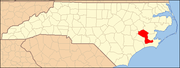
Towns Bridgeton | Cove City | Dover | River Bend | Trent Woods | Vanceboro
CDPs Military base Categories:- North Carolina counties
- Craven County, North Carolina
- New Bern micropolitan area


Wikimedia Foundation. 2010.