- National Register of Historic Places listings in Craven County, North Carolina
-

This list includes properties and districts listed on the National Register of Historic Places in Craven County, North Carolina. Click the "Map of all coordinates" link to the right to view a Google map of all properties and districts with latitude and longitude coordinates in the table below.[1]
-
- This National Park Service list is complete through NPS recent listings posted November 10, 2011.[2]
[3] Landmark name[4] Image Date listed Location City or Town Summary 1 Attmore-Oliver House 
January 20, 1972 513 Broad St.
35°6′30″N 77°2′31″W / 35.10833°N 77.04194°WNew Bern 2 J.T. Barber School December 20, 2006 1700 Cobb St.
35°7′4″N 77°3′54″W / 35.11778°N 77.065°WNew Bern 3 Baxter Clock July 2, 1973 323 Pollock St.
35°6′23″N 77°2′22″W / 35.10639°N 77.03944°WNew Bern 4 Bellair 
August 25, 1972 W of New Bern off SR 1401
35°10′50″N 77°7′19″W / 35.18056°N 77.12194°WNew Bern 5 Blades House January 14, 1972 602 Middle St.
35°6′40″N 77°2′21″W / 35.11111°N 77.03917°WNew Bern 6 Bryan House and Office March 24, 1972 603-605 Pollock St.
35°6′24″N 77°2′38″W / 35.10667°N 77.04389°WNew Bern 7 Cedar Grove Cemetery December 5, 1972 Bounded by Queen, George, Cypress, Howard, and Metcalf Sts.
35°6′53″N 77°2′41″W / 35.11472°N 77.04472°WNew Bern 8 Cedar Street Recreation Center August 21, 2003 822 Cedar St.
35°6′44″N 77°2′47″W / 35.11222°N 77.04639°WNew Bern 9 Centenary Methodist Church September 11, 1972 209 New St.
35°6′32″N 77°2′21″W / 35.10889°N 77.03917°WNew Bern 10 Central Elementary School January 20, 1972 311-313 New St. and 517 Hancock St.
35°6′36″N 77°2′29″W / 35.11°N 77.04139°WNew Bern 11 Christ Episcopal Church and Parish House April 13, 1973 320 Pollock St.
35°6′25″N 77°2′23″W / 35.10694°N 77.03972°WNew Bern 12 Clear Springs Plantation March 14, 1973 N of Jasper
35°12′57″N 77°12′3″W / 35.21583°N 77.20083°WJasper 13 Coor-Bishop House November 9, 1972 501 E. Front St.
35°6′33″N 77°2′10″W / 35.10917°N 77.03611°WNew Bern 14 Coor-Gaston House February 1, 1972 421 Craven St.
35°6′32″N 77°2′18″W / 35.10889°N 77.03833°WNew Bern 15 DeGraffenried Park Historic District August 9, 2006 Roughly bounded by Neuse Blvd., Fort Totten Dr., Trent Rd. and Chattawka Ln.
35°6′27″N 77°3′38″W / 35.1075°N 77.06056°WNew Bern 16 Ebenezer Presbyterian Church June 30, 1997 720 Bern St.
35°6′42″N 77°2′46″W / 35.11167°N 77.04611°WNew Bern 17 First Baptist Church March 24, 1972 Middle St. and Church Alley
35°6′11″N 77°2′45″W / 35.10306°N 77.04583°WNew Bern 18 First Church of Christ, Scientist October 2, 1973 406 and 408 Middle St.
35°6′29″N 77°2′22″W / 35.10806°N 77.03944°WNew Bern 19 First Missionary Baptist Church June 30, 1997 819 Cypress St.
35°6′51″N 77°2′51″W / 35.11417°N 77.0475°WNew Bern 20 First Presbyterian Church and Churchyard February 1, 1972 New St. between Middle and Hancock Sts.
35°6′35″N 77°2′25″W / 35.10972°N 77.04028°WNew Bern 21 Ghent Historic District March 17, 1988 Roughly bounded by Trent Blvd., First St., Park Ave., and Seventh St.
35°6′18″N 77°3′45″W / 35.105°N 77.0625°WNew Bern 22 Gull Harbor August 14, 1973 514 E. Front St.
35°6′36″N 77°2′8″W / 35.11°N 77.03556°WNew Bern 23 Harvey Mansion 
November 12, 1971 219 Tryon Palace Dr.
35°6′16″N 77°2′17″W / 35.10444°N 77.03806°WNew Bern 24 Hawks House March 16, 1972 306 Hancock St.
35°6′27″N 77°2′29″W / 35.1075°N 77.04139°WNew Bern 25 William Hollister House June 30, 1972 613 Broad St.
35°6′33″N 77°2′40″W / 35.10917°N 77.04444°WNew Bern 26 Thomas Jerkins House October 18, 1972 305 Johnson St.
35°6′37″N 77°2′21″W / 35.11028°N 77.03917°WNew Bern 27 Jerkins-Duffy House March 17, 1988 301 Johnston St.
35°6′37″N 77°2′18″W / 35.11028°N 77.03833°WNew Bern 28 Jones-Jarvis House April 11, 1973 528 E. Front St.
35°6′40″N 77°2′11″W / 35.11111°N 77.03639°WNew Bern 29 Ulysses S. Mace House June 4, 1973 518 Broad St.
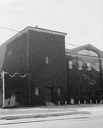
35°6′31″N 77°2′34″W / 35.10861°N 77.04278°WNew Bern 30 Masonic Temple and Theater 
March 16, 1972 516 Hancock St.
35°6′39″N 77°2′25″W / 35.11083°N 77.04028°WNew Bern 31 Mount Shiloh Missionary Baptist Church March 1, 2007 307 Scott St.
35°4′48″N 77°2′18″W / 35.08°N 77.03833°WNew Bern 32 New Bern Battlefield Site October 19, 2001 US 70 E., approx. 4.5 miles SE of New Bern
35°2′39″N 77°0′56″W / 35.04417°N 77.01556°WNew Bern 33 New Bern Historic District June 19, 1973 Roughly bounded by Neuse and Trent Rivers and Queen St.; also roughly 2 blocks of N. Craven, 1 block of Pasteur St., and roughly along Bern, West, and Cedar Sts. and Trent Court
35°6′56″N 77°2′58″W / 35.11556°N 77.04944°WNew Bern Second set of boundaries represents a boundary increase of September 25, 2003 34 New Bern Municipal Building June 4, 1973 Pollock and Craven Sts.
35°6′25″N 77°2′19″W / 35.10694°N 77.03861°WNew Bern 35 New Bern National Cemetery January 31, 1997 1711 National Ave.
35°7′25″N 77°3′12″W / 35.12361°N 77.05333°WNew Bern 36 Rhem-Waldrop House October 18, 1972 701 Broad St.
35°6′29″N 77°2′43″W / 35.10806°N 77.04528°WNew Bern 37 Riverside Historic District February 9, 1988 Roughly bounded by N. Craven St., North Ave., E St., and Guion St.
35°7′9″N 77°2′51″W / 35.11917°N 77.0475°WNew Bern 38 Rue Chapel AME Church June 30, 1997 709 Oak St.
35°6′39″N 77°3′0″W / 35.11083°N 77.05°WNew Bern 39 Dr. Earl S. Sloan House August 14, 1986 3701 Country Club Rd.
35°4′54″N 77°4′58″W / 35.08167°N 77.08278°WTrent Woods 40 Slover-Bradham House 
April 11, 1973 201 Johnson St.
35°6′39″N 77°2′13″W / 35.11083°N 77.03694°WNew Bern 41 Eli Smallwood House December 5, 1972 524 E. Front St.
35°6′39″N 77°2′11″W / 35.11083°N 77.03639°WNew Bern 42 Isaac H. Smith, Jr., House September 14, 2002 605 Johnson St.
35°6′37″N 77°2′37″W / 35.11028°N 77.04361°WNew Bern 43 Benjamin Smith House April 13, 1972 210 Hancock St.
35°6′19″N 77°2′31″W / 35.10528°N 77.04194°WNew Bern 44 Smith-Whitford House April 13, 1972 506 Craven St.
35°6′36″N 77°2′16″W / 35.11°N 77.03778°WNew Bern 45 St. John's Missionary Baptist Church June 30, 1997 1130 Walt Bellamy Dr.
35°6′16″N 77°3′12″W / 35.10444°N 77.05333°WNew Bern 46 St. Paul's Roman Catholic Church 
March 24, 1972 510 Middle St.
35°6′35″N 77°2′22″W / 35.10972°N 77.03944°WNew Bern 47 St. Peter's AME Zion Church June 30, 1997 615 Queen St.
35°6′37″N 77°2′37″W / 35.11028°N 77.04361°WNew Bern 48 Edward R. Stanly House March 24, 1972 502 Pollock St.
35°6′31″N 77°2′31″W / 35.10861°N 77.04194°WNew Bern 49 John Wright Stanly House 
February 26, 1970 307 George St.
35°6′26″N 77°2′41″W / 35.10722°N 77.04472°WNew Bern 50 Stevenson House August 26, 1971 609-611 Pollock St.
35°6′24″N 77°2′38″W / 35.10667°N 77.04389°WNew Bern 51 Isaac Taylor House December 27, 1972 228 Craven St.
35°6′19″N 77°2′18″W / 35.10528°N 77.03833°WNew Bern 52 Tisdale-Jones House April 25, 1972 520 New St.
35°6′36″N 77°2′33″W / 35.11°N 77.0425°WNew Bern 53 York-Gordon House June 18, 1973 213 Hancock St.
35°6′13″N 77°2′37″W / 35.10361°N 77.04361°WNew Bern See also
- National Register of Historic Places listings in North Carolina
- List of National Historic Landmarks in North Carolina
References
- ^ The latitude and longitude information provided in this table was derived originally from the National Register Information System, which has been found to be fairly accurate for about 99% of listings. For about 1% of NRIS original coordinates, experience has shown that one or both coordinates are typos or otherwise extremely far off; some corrections may have been made. A more subtle problem causes many locations to be off by up to 150 yards, depending on location in the country: most NRIS coordinates were derived from tracing out latitude and longitudes off of USGS topographical quadrant maps created under the North American Datum of 1927, which differs from the current, highly accurate WGS84 GPS system used by Google maps. Chicago is about right, but NRIS longitudes in Washington are higher by about 4.5 seconds, and are lower by about 2.0 seconds in Maine. Latitudes differ by about 1.0 second in Florida. Some locations in this table may have been corrected to current GPS standards.
- ^ "National Register of Historic Places: Weekly List Actions". National Park Service, United States Department of the Interior. Retrieved on November 10, 2011.
- ^ Numbers represent an ordering by significant words. Various colorings, defined here, differentiate National Historic Landmark sites and National Register of Historic Places Districts from other NRHP buildings, structures, sites or objects.
- ^ "National Register Information System". National Register of Historic Places. National Park Service. 2008-04-24. http://nrhp.focus.nps.gov/natreg/docs/All_Data.html.
U.S. National Register of Historic Places Topics Lists by states Alabama • Alaska • Arizona • Arkansas • California • Colorado • Connecticut • Delaware • Florida • Georgia • Hawaii • Idaho • Illinois • Indiana • Iowa • Kansas • Kentucky • Louisiana • Maine • Maryland • Massachusetts • Michigan • Minnesota • Mississippi • Missouri • Montana • Nebraska • Nevada • New Hampshire • New Jersey • New Mexico • New York • North Carolina • North Dakota • Ohio • Oklahoma • Oregon • Pennsylvania • Rhode Island • South Carolina • South Dakota • Tennessee • Texas • Utah • Vermont • Virginia • Washington • West Virginia • Wisconsin • WyomingLists by territories Lists by associated states Other Municipalities and communities of Craven County, North Carolina Cities 
Towns Bridgeton | Cove City | Dover | River Bend | Trent Woods | Vanceboro
CDPs Military base Categories:- Craven County, North Carolina
- National Register of Historic Places in North Carolina
- Buildings and structures in Craven County, North Carolina
-


Wikimedia Foundation. 2010.