- National Register of Historic Places listings in Catawba County, North Carolina
-

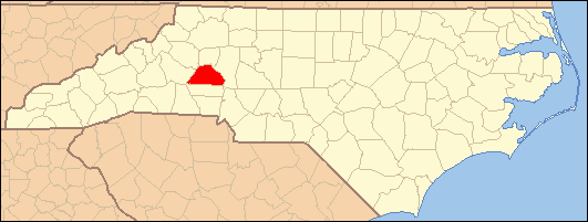
This list includes properties and districts listed on the National Register of Historic Places in Catawba County, North Carolina. Click the "Map of all coordinates" link to the right to view a Google map of all properties and districts with latitude and longitude coordinates in the table below.[1]
-
- This National Park Service list is complete through NPS recent listings posted November 10, 2011.[2]
[3] Landmark name[4] Image Date listed Location City or Town Summary 1 Abraham Anthony Farm May 10, 1990 W side of SR 1008, 0.5 miles S of jct. with SR 2021
35°34′28″N 81°18′38″W / 35.57444°N 81.31056°WBlackburn 2 Balls Creek Campground April 27, 1990 W side of SR 1003, 0.1 miles S of SR 1943
35°37′46″N 81°5′50″W / 35.62944°N 81.09722°WBandy's Crossroads 3 Bandy Farms Historic District April 27, 1990 E side of SR 1003, 0.5-0.85 miles S of SR 1813 jct.
35°37′51″N 81°5′35″W / 35.63083°N 81.09306°WBandy's Crossroads 4 Bolick Historic District July 5, 1990 First Ave. S. between US 64/70 and 12th St.
35°41′49″N 81°13′15″W / 35.69694°N 81.22083°WConover 5 Bost-Burris House July 5, 1990 Jct. of SR 1149 and SR 1154
35°40′0″N 81°14′58″W / 35.666667°N 81.24944°WNewton 6 Bunker Hill Covered Bridge 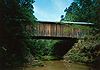
February 26, 1970 2 miles E of Claremont on U.S. 70
35°43′20″N 81°6′36″W / 35.72222°N 81.11°WClaremont 7 Catawba County Courthouse May 10, 1979 S. Main, W.A, S. College, and W. 1st Sts.
35°39′47″N 81°13′19″W / 35.66306°N 81.22194°WNewton 8 Catawba Historic District April 28, 1986 Roughly bounded by Second Ave. NE, Third and Second Sts. SE, Second Ave. SW and NC 10, and Second St. SW
35°42′26″N 81°4′30″W / 35.70722°N 81.075°WCatawba 9 Claremont High School Historic District October 23, 1986 Roughly bounded by Fifth and Third Aves., Third St., Second Ave. and N. Center St.; also 505-753 N. Center St., 102-126 and 401 2nd Ave., NE., 406-602 3rd Ave., NE., 12-118 5th Ave., NW., and 212-258 5th Ave.
35°44′8″N 81°20′41″W / 35.73556°N 81.34472°WHickory Second set of boundaries represents a boundary increase of December 18, 2009 10 Elliott–Carnegie Library March 15, 1985 415 - 1st Ave. NW
35°43′58″N 81°20′42″W / 35.73278°N 81.345°WHickory 11 First Presbyterian Church March 15, 1985 2nd St. and 3rd Ave. NW
35°44′7″N 81°20′25″W / 35.73528°N 81.34028°WHickory 12 Foil–Cline House July 5, 1990 406 S. Main Ave.
35°39′29″N 81°13′29″W / 35.65806°N 81.22472°WNewton 13 Dr. Glenn R. Frye House August 5, 2009 539 N. Center St., NE
35°44′22″N 81°20′17″W / 35.73944°N 81.33806°WHickory 14 Clement Geitner House March 15, 1985 436 Main Ave. NW
35°43′57″N 81°20′45″W / 35.7325°N 81.34583°WHickory 15 Grace Reformed Church July 5, 1990 201-211 S. Main Ave.
35°39′40″N 81°13′23″W / 35.66111°N 81.22306°WNewton 16 Grace Union Church and Cemetery May 10, 1990 Jct. of SR 1008 and SR 2030
35°35′56″N 81°19′2″W / 35.59889°N 81.31722°WBlackburn 17 Harris Arcade May 8, 2008 221-229 1st Ave. NW.
35°43′59″N 81°20′26″W / 35.73306°N 81.34056°WHickory 18 Hickory Municipal Building February 18, 2000 30 Third St., SW
35°43′57″N 81°20′32″W / 35.7325°N 81.34222°WHickory 19 Hickory Southwest Downtown Historic District December 16, 2005 Portions of Government Ave.SE, Second Street Place SE, First Ave. SW and Third St. SW
35°43′51″N 81°20′28″W / 35.73083°N 81.34111°WHickory 20 Highland School June 1, 1990 1017 10th Ave. NE.
35°44′33″N 81°18′59″W / 35.7425°N 81.31639°WHickory 21 Houck's Chapel March 15, 1985 9th Ave. and 17th St. NW
35°44′41″N 81°22′7″W / 35.74472°N 81.36861°WHickory 22 George Huffman Farm June 21, 1990 SR 1479, SE of jct. with Tate Blvd.
35°42′45″N 81°15′16″W / 35.7125°N 81.25444°WConover 23 Keever–Cansler Farm May 10, 1990 E side of SR 2024, 0.05 miles N of jct. with SR 2026
35°34′48″N 81°19′33″W / 35.58°N 81.32583°WBlackburn 24 Kenworth Historic District May 9, 1985 Roughly bounded by 2nd Ave., 5th St. and 3rd Ave. Dr. SE; also roughly along 5th St., SE., 5th Ave., SE., 3rd Ave. Dr., SE., and 2nd Ave., SE.
35°43′40″N 81°19′45″W / 35.72778°N 81.32917°WHickory Second set of boundaries represents a boundary increase of May 18, 2005 25 John A. Lentz House March 15, 1985 321 9th St. NW
35°44′11″N 81°21′9″W / 35.73639°N 81.3525°WHickory 26 Long, McCorkle and Murray Houses September 5, 1990 1310-1326 N. Main Ave.
35°40′35″N 81°13′16″W / 35.67639°N 81.22111°WNewton 27 Lyerly Full Fashioned Mill August 8, 2007 56 Third St., SE
35°44′1″N 81°19′59″W / 35.73361°N 81.33306°WHickory 28 Memorial Reformed Church June 21, 1990 201 E. Main St.
35°34′30″N 81°12′36″W / 35.575°N 81.21°WMaiden 29 Miller–Cansler House May 10, 1990 N side of SR 2007, 0.5 miles E of jct. with SR 1005
35°35′47″N 81°15′14″W / 35.59639°N 81.25389°WMaiden 30 Alexander Moore Farm April 27, 1990 SR 2646 0.5 miles NW of SR 1004 jct.
35°42′5″N 81°0′2″W / 35.70139°N 81.00056°WCatawba 31 John Alfred Moretz House March 15, 1985 1437 - 6th St. Circle NW
35°45′23″N 81°21′6″W / 35.75639°N 81.35167°WHickory 32 Munday House August 22, 1975 Address Restricted Denver 33 Murray's Mill Historic District December 31, 1979 SE of Catawba
35°40′27″N 81°5′44″W / 35.67417°N 81.09556°WCatawba 34 Neill–Turner–Lester House May 10, 1990 N side of SR 1836, 0.25 miles NE of jct. with SR 1837
35°38′59″N 80°57′48″W / 35.64972°N 80.96333°WSherrills Ford 35 North Main Avenue Historic District May 22, 1986 Roughly bounded by W. Ninth St., N. Main Ave., W. Fourth and W. Sixth Sts., N. Deal Ave., and W. Eighth St.
35°40′8″N 81°13′26″W / 35.66889°N 81.22389°WNewton 36 Oakwood Historic District March 25, 1986 Roughly bounded by Oakwood Cemetery and Fourth Ave. NW, Fourth St. NW, Second Ave. NW, and Sixth St. NW
35°44′15″N 81°20′43″W / 35.7375°N 81.34528°WHickory 37 Perkins House October 1, 1974 N of Catawba off I-40
35°44′00″N 81°04′23″W / 35.7333333°N 81.07306°WNewton 38 Piedmont Wagon Company March 15, 1985 Main Ave. NW
35°43′56″N 81°21′17″W / 35.73222°N 81.35472°WHickory 39 Powell–Trollinger Lime Kilns November 8, 1974 S of Catawba
35°39′11″N 81°3′51″W / 35.65306°N 81.06417°WCatawba 40 Propst House April 24, 1973 Shuford Memorial Garden
35°44′16″N 81°22′45″W / 35.73778°N 81.37917°WHickory 41 David F. Propst House June 21, 1990 Jct. of SR 1810 and SR 1878
35°35′51″N 81°11′8″W / 35.5975°N 81.18556°WMaiden 42 Franklin D. Reinhardt and Harren–Hood Farms June 21, 1990 SR 2013 NW of junction with SR 2012
35°37′5″N 81°14′21″W / 35.61806°N 81.23917°WMaiden 43 William Pinckney Reinhardt House July 19, 1990 Junction of SR 2012 and SR 2013
35°36′20″N 81°14′15″W / 35.60556°N 81.2375°WMaiden 44 Ridgeview Public Library May 12, 2011 415 1st St., S.W.
35°43′37″N 81°20′20″W / 35.72694°N 81.33889°WHickory 45 Rock Barn Farm July 5, 1990 W side of SR 1709, .4 miles N of jct. with SR 1715
35°44′32″N 81°9′39″W / 35.74222°N 81.16083°WClaremont 46 Rudisill–Wilson House August 14, 1973 SW of Newton off NC 10
35°36′58″N 81°15′23″W / 35.61611°N 81.25639°WNewton 47 Self–Trott–Bickett House July 5, 1990 331 S. College Ave.
35°39′32″N 81°13′22″W / 35.65889°N 81.22278°WNewton 48 Sharpe–Gentry Farm June 21, 1990 Jct. of NC 10 and SR 1137
35°37′41″N 81°22′22″W / 35.62806°N 81.37278°WPropst Crossroads 49 Miles Alexander Sherrill House April 27, 1990 W side of SR 1849, 0.1 miles S of SR 1848 jct.
35°37′37″N 81°0′28″W / 35.62694°N 81.00778°WSherrills Ford 50 Shuford House April 24, 1973 542 2nd St. NE.
35°44′26″N 81°20′0″W / 35.74056°N 81.333333°WHickory 51 Shuford–Hoover House May 10, 1990 E side of SR 1008, 0.05 miles S of jct. with SR 10
35°37′24″N 81°19′16″W / 35.62333°N 81.32111°WBlackburn 52 St. Paul's Church and Cemetery December 9, 1971 Jct. of SR 1149 and SR 1164
35°40′35″N 81°14′38″W / 35.67639°N 81.24389°WNewton 53 St. Paul's Reformed Church June 21, 1990 Jct. of SR 1151 and SR 1005
35°38′52″N 81°16′5″W / 35.64778°N 81.26806°WStartown 54 Terrell Historic District July 15, 1986 NC 150 and SR 1848
35°33′34″N 80°58′38″W / 35.55944°N 80.97722°WTerrell 55 Warlick–Huffman Farm June 21, 1990 SR 1116 NW of jct. with NC 10
35°37′4″N 81°24′48″W / 35.61778°N 81.41333°WPropst Crossroads 56 Weidner Rock House December 4, 1973 S of Hickory on SR 1142
35°38′42″N 81°18′35″W / 35.645°N 81.30972°WHickory 57 Wesley's Chapel Arbor and Cemetery May 10, 1990 W side of SR 2033, 0.4 miles S of jct. with SR 10
35°36′55″N 81°20′55″W / 35.61528°N 81.34861°WBlackburn 58 Wilfong–Wilson Farm June 21, 1990 SR 1145, SW of jct. with SR 1146
35°38′41″N 81°17′40″W / 35.64472°N 81.29444°WStartown 59 Yoder's Mills Historic District January 11, 1980 Address Restricted Hickory See also
- National Register of Historic Places listings in North Carolina
- List of National Historic Landmarks in North Carolina
References
- ^ The latitude and longitude information provided in this table was derived originally from the National Register Information System, which has been found to be fairly accurate for about 99% of listings. For about 1% of NRIS original coordinates, experience has shown that one or both coordinates are typos or otherwise extremely far off; some corrections may have been made. A more subtle problem causes many locations to be off by up to 150 yards, depending on location in the country: most NRIS coordinates were derived from tracing out latitude and longitudes off of USGS topographical quadrant maps created under North American Datum of 1927, which differs from the current, highly accurate GPS system used by Google maps. Chicago is about right, but NRIS longitudes in Washington are higher by about 4.5 seconds, and are lower by about 2.0 seconds in Maine. Latitudes differ by about 1.0 second in Florida. Some locations in this table may have been corrected to current GPS standards.
- ^ "National Register of Historic Places: Weekly List Actions". National Park Service, United States Department of the Interior. Retrieved on November 10, 2011.
- ^ Numbers represent an ordering by significant words. Various colorings, defined here, differentiate National Historic Landmark sites and National Register of Historic Places Districts from other NRHP buildings, structures, sites or objects.
- ^ "National Register Information System". National Register of Historic Places. National Park Service. 2008-04-24. http://nrhp.focus.nps.gov/natreg/docs/All_Data.html.
U.S. National Register of Historic Places Topics Lists by states Alabama • Alaska • Arizona • Arkansas • California • Colorado • Connecticut • Delaware • Florida • Georgia • Hawaii • Idaho • Illinois • Indiana • Iowa • Kansas • Kentucky • Louisiana • Maine • Maryland • Massachusetts • Michigan • Minnesota • Mississippi • Missouri • Montana • Nebraska • Nevada • New Hampshire • New Jersey • New Mexico • New York • North Carolina • North Dakota • Ohio • Oklahoma • Oregon • Pennsylvania • Rhode Island • South Carolina • South Dakota • Tennessee • Texas • Utah • Vermont • Virginia • Washington • West Virginia • Wisconsin • WyomingLists by territories Lists by associated states Other  Category:National Register of Historic Places •
  Portal:National Register of Historic Places
Municipalities and communities of Catawba County, North Carolina County seat: Newton City 
Towns CDPs Unincorporated
communitiesFootnotes ‡This populated place also has portions in an adjacent county or counties
Categories:- Catawba County, North Carolina
- National Register of Historic Places in North Carolina
- Buildings and structures in Catawba County, North Carolina
-

Wikimedia Foundation. 2010.