- National Register of Historic Places listings in Burke County, North Carolina
-

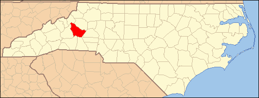
This list includes properties and districts listed on the National Register of Historic Places in Burke County, North Carolina. Click the "Map of all coordinates" link to the right to view a Google map of all properties and districts with latitude and longitude coordinates in the table below.[1]
-
- This National Park Service list is complete through NPS recent listings posted November 10, 2011.[2]
[3] Landmark name[4] Image Date listed Location City or Town Summary 1 Avery Avenue Historic District November 9, 1987 Roughly along parts of Avery, Lenoir, Morehead, Walker, Evans, & Short Sts.
35°45′11″N 81°41′18″W / 35.75306°N 81.68833°WMorganton 2 Avery Avenue School November 9, 1987 200 Avery Ave.
35°44′52″N 81°41′14″W / 35.74778°N 81.68722°WMorganton 3 Alphonse Calhoun Avery House July 12, 1984 408 N. Green St.
35°44′53″N 81°41′36″W / 35.74806°N 81.69333°WMorganton 4 Bellevue 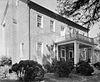
December 4, 1973 On SR 1419, N of Morganton off NC 18
35°46′55″N 81°42′33″W / 35.78194°N 81.70917°WMorganton 5 Broughton Hospital Historic District November 9, 1987 Roughly bounded by Broughton Hospital campus, NC 18, Bickett St., & Enola Rd.
35°43′39″N 81°40′40″W / 35.7275°N 81.67778°WMorganton 6 Burke County Courthouse 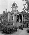
April 17, 1970 Courthouse Sq.
35°44′44″N 81°41′7″W / 35.74556°N 81.68528°WMorganton 7 Creekside February 1, 1972 W of Morganton at jct. of U.S. 70 and 70A
35°44′7″N 81°42′31″W / 35.73528°N 81.70861°WMorganton 8 Dale's, USB Market November 9, 1987 Jct. of Enola Rd. & Dale St.
35°43′33″N 81°40′20″W / 35.72583°N 81.67222°WMorganton 9 Jean-Pierre Auguste Dalmas House May 2, 2002 4950 Villar Lane, NE
35°45′28″N 81°33′50″W / 35.75778°N 81.56389°WValdese 10 Jacob Forney Jr. House October 14, 1976 NW of Morganton on SR 1440
35°48′1″N 81°43′10″W / 35.80028°N 81.71944°WMorganton 11 Franklin-Penland House November 28, 2006 8646 NC 183
35°57′11″N 81°56′12″W / 35.95306°N 81.93667°WLinville Falls 12 Gaither House April 23, 1976 102 N. Anderson St.
35°44′29″N 81°41′33″W / 35.74139°N 81.6925°WMorganton 13 Garrou-Morganton Full-Fashioned Hosiery Mills January 27, 1999 101 and 105 Lenoir St.
35°44′51″N 81°41′13″W / 35.7475°N 81.68694°WMorganton 14 Gaston Chapel October 11, 1984 100 Bouchelle St.
35°44′51″N 81°41′14″W / 35.7475°N 81.68722°WMorganton 15 Gilboa Methodist Church October 11, 1984 U.S. 64
35°41′17″N 81°43′45″W / 35.68806°N 81.72917°WSalem 16 Hunting Creek Railroad Bridge November 9, 1987 Hunting Creek N of US 64 & 70 between jct. of Stonebridge Rd. & E. Union St.
35°45′5″N 81°39′31″W / 35.75139°N 81.65861°WMorganton 17 Jonesboro Historic District November 9, 1987 Roughly bounded by W. Concord, Bay, Jones, Lytle, & S. Anderson Sts.
35°44′20″N 81°41′22″W / 35.73889°N 81.68944°WMorganton 18 John Alexander Lackey House November 9, 1987 102 Camelot Dr.
35°46′5″N 81°43′7″W / 35.76806°N 81.71861°WMorganton 19 Magnolia Place June 4, 1973 S of Morganton on U.S. 64
35°43′4″N 81°41′38″W / 35.71778°N 81.69389°WMorganton 20 Morganton Downtown Historic District November 9, 1987 E. Union, S. Green, N. & S. Sterling, King & Queen Sts.
35°44′45″N 81°41′16″W / 35.74583°N 81.68778°WMorganton 21 Mountain View October 11, 1984 604 W. Union St.
35°44′23″N 81°41′50″W / 35.73972°N 81.69722°WMorganton 22 North Carolina School for the Deaf Historic District April 20, 1989 Jct. US 70 and US 64
35°43′47″N 81°41′17″W / 35.72972°N 81.68806°WMorganton 23 North Carolina School for the Deaf: Main Building December 12, 1976 U.S. 64 and Fleming Dr.
35°43′47″N 81°41′25″W / 35.72972°N 81.69028°WMorganton 24 North Green Street-Bouchelle Street Historic District November 9, 1987 N. Green, Bouchelle, & Patterson Sts.
35°44′55″N 81°41′31″W / 35.74861°N 81.69194°WMorganton 25 Quaker Meadows 
October 3, 1973 W of Morganton off NC 181
35°45′26″N 81°43′15″W / 35.75722°N 81.72083°WMorganton 26 Quaker Meadows Cemetery November 9, 1987 Off NC 126
35°45′6″N 81°43′18″W / 35.75167°N 81.72167°WMorganton 27 Dr. Joseph Bennett Riddle House December 20, 1984 411 W. Union St.
35°44′24″N 81°41′37″W / 35.74°N 81.69361°WMorganton 28 Sloan-Throneburg Farm March 1, 2002 NC 1429, 0.3 miles W of jct. with NC 1450
35°50′36″N 81°39′27″W / 35.84333°N 81.6575°WChesterfield 29 South King Street Historic District November 9, 1987 S. King St.
35°44′34″N 81°41′12″W / 35.74278°N 81.68667°WMorganton 30 Swan Ponds April 24, 1973 About 4 miles W of Morganton off NC 126
35°44′36″N 81°45′23″W / 35.74333°N 81.75639°WMorganton 31 Tate House May 25, 1973 100 S. King St.
35°44′39″N 81°41′21″W / 35.74417°N 81.68917°WMorganton 32 Franklin Pierce Tate House May 21, 1986 410 W. Union St.
35°44′26″N 81°41′41″W / 35.74056°N 81.69472°WMorganton 33 Valdese Elementary School October 25, 1984 400 Main St.
35°44′41″N 81°34′1″W / 35.74472°N 81.56694°WValdese 34 Waldensian Presbyterian Church October 25, 1984 104 E. Main St.
35°44′34″N 81°33′45″W / 35.74278°N 81.5625°WValdese 35 West Union Street Historic District November 9, 1987 Roughly parts of W. Union St., Montrose St., & Riverside Dr.
35°44′26″N 81°41′42″W / 35.74056°N 81.695°WMorganton 36 Western North Carolina Insane Asylum October 5, 1977 Off NC 18
35°43′50″N 81°40′30″W / 35.73056°N 81.675°WMorganton 37 White Street-Valdese Avenue Historic District November 9, 1987 White St. & Valdese Ave.
35°44′50″N 81°40′51″W / 35.74722°N 81.68083°WMorganton See also
- National Register of Historic Places listings in North Carolina
- List of National Historic Landmarks in North Carolina
References
- ^ The latitude and longitude information provided in this table was derived originally from the National Register Information System, which has been found to be fairly accurate for about 99% of listings. For about 1% of NRIS original coordinates, experience has shown that one or both coordinates are typos or otherwise extremely far off; some corrections may have been made. A more subtle problem causes many locations to be off by up to 150 yards, depending on location in the country: most NRIS coordinates were derived from tracing out latitude and longitudes off of USGS topographical quadrant maps created under the North American Datum of 1927, which differs from the current, highly accurate WGS84 GPS system used by Google maps. Chicago is about right, but NRIS longitudes in Washington are higher by about 4.5 seconds, and are lower by about 2.0 seconds in Maine. Latitudes differ by about 1.0 second in Florida. Some locations in this table may have been corrected to current GPS standards.
- ^ "National Register of Historic Places: Weekly List Actions". National Park Service, United States Department of the Interior. Retrieved on November 10, 2011.
- ^ Numbers represent an ordering by significant words. Various colorings, defined here, differentiate National Historic Landmark sites and National Register of Historic Places Districts from other NRHP buildings, structures, sites or objects.
- ^ "National Register Information System". National Register of Historic Places. National Park Service. 2008-04-24. http://nrhp.focus.nps.gov/natreg/docs/All_Data.html.
U.S. National Register of Historic Places Topics Lists by states Alabama • Alaska • Arizona • Arkansas • California • Colorado • Connecticut • Delaware • Florida • Georgia • Hawaii • Idaho • Illinois • Indiana • Iowa • Kansas • Kentucky • Louisiana • Maine • Maryland • Massachusetts • Michigan • Minnesota • Mississippi • Missouri • Montana • Nebraska • Nevada • New Hampshire • New Jersey • New Mexico • New York • North Carolina • North Dakota • Ohio • Oklahoma • Oregon • Pennsylvania • Rhode Island • South Carolina • South Dakota • Tennessee • Texas • Utah • Vermont • Virginia • Washington • West Virginia • Wisconsin • WyomingLists by territories Lists by associated states Other Municipalities and communities of Burke County, North Carolina Cities 
Towns Connellys Springs | Drexel | Glen Alpine | Hildebran | Long View‡ | Rhodhiss‡ | Rutherford College | Valdese
CDPs Unincorporated
communitiesJonas Ridge | Linville Falls‡ | Petersburg
Townships Drexel | Icard | Jonas Ridge | Linville | Lovelady | Lower Creek | Lower Fork | Morganton | Quaker Meadows | Silver Creek | Smoky Creek | Upper Creek | Upper Fork | Valdese
Footnotes ‡This populated place also has portions in an adjacent county or counties
Categories:- Burke County, North Carolina
- National Register of Historic Places in North Carolina
- Buildings and structures in Burke County, North Carolina
-


Wikimedia Foundation. 2010.