- National Register of Historic Places listings in Stanly County, North Carolina
-

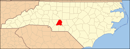
This list includes properties and districts listed on the National Register of Historic Places in Stanly County, North Carolina. Click the "Map of all coordinates" link to the right to view a Google map of all properties and districts with latitude and longitude coordinates in the table below.[1]
-
- This National Park Service list is complete through NPS recent listings posted November 10, 2011.[2]
[3] Landmark name[4] Image Date listed Location City or Town Summary 1 Badin Historic District October 12, 1983 Roughly bounded by NC 740, Pine St., and Country Club property line
35°24′13″N 80°6′45″W / 35.40361°N 80.1125°WBadin 2 Thomas Marcellus Denning House January 24, 2011 415 N. Second St.
35°21′22″N 80°11′53″W / 35.35611°N 80.19806°WAlbemarle 3 Downtown Albemarle Historic District March 28, 2002 Portions of S. 2nd, W. Main and N. and S. 1st Sts.
35°21′0″N 80°11′58″W / 35.35°N 80.19944°WAlbemarle 4 Five Points Historic District October 16, 2002 Jct. of E. Main St., Pee Dee Ave., and 4th St.
35°21′1″N 80°11′41″W / 35.35028°N 80.19472°WAlbemarle 5 Hardaway Site (31ST4) March 1, 1984 Address Restricted Badin 6 Narrows Dam and Power Plant Complex October 12, 1983 Yadkin River and SR 1704
35°25′7″N 80°5′33″W / 35.41861°N 80.0925°WBadin 7 Opera House-Starnes Jewelers Building March 9, 1995 127-133 W. Main St.
35°21′1″N 80°11′56″W / 35.35028°N 80.19889°WAlbemarle 8 Pee Dee Avenue Historic District January 7, 1998 Along Pee Dee Ave., roughly from Arey Ave. to Miller St.
35°21′12″N 80°11′13″W / 35.35333°N 80.18694°WAlbemarle 9 Pfeiffer Junior College Historic District April 28, 1999 US 52, 1.0 miles N. of jct. with NC 49
35°29′5″N 80°17′4″W / 35.48472°N 80.28444°WMisenheimer 10 Randle House September 8, 1992 S side of NC 1802 at jct. with NC 1743
35°15′45″N 80°6′15″W / 35.2625°N 80.10417°WNorwood 11 Second Street Historic District April 6, 2005 Portions of 100 and 200 blks N. Second st. and 100 blk West North St.
35°21′8″N 80°11′54″W / 35.35222°N 80.19833°WAlbemarle 12 Isaiah Wilson Snugs House March 9, 1995 112 N. Third St.
35°21′3″N 80°11′46″W / 35.35083°N 80.19611°WAlbemarle 13 West Badin Historic District October 12, 1983 Roughly bounded by Sims, Lincoln, Marion, and Lee Sts.
35°24′35″N 80°7′28″W / 35.40972°N 80.12444°WBadin See also
- National Register of Historic Places listings in North Carolina
- List of National Historic Landmarks in North Carolina
References
- ^ The latitude and longitude information provided in this table was derived originally from the National Register Information System, which has been found to be fairly accurate for about 99% of listings. For about 1% of NRIS original coordinates, experience has shown that one or both coordinates are typos or otherwise extremely far off; some corrections may have been made. A more subtle problem causes many locations to be off by up to 150 yards, depending on location in the country: most NRIS coordinates were derived from tracing out latitude and longitudes off of USGS topographical quadrant maps created under North American Datum of 1927, which differs from the current, highly accurate GPS system used by Google maps. Chicago is about right, but NRIS longitudes in Washington are higher by about 4.5 seconds, and are lower by about 2.0 seconds in Maine. Latitudes differ by about 1.0 second in Florida. Some locations in this table may have been corrected to current GPS standards.
- ^ "National Register of Historic Places: Weekly List Actions". National Park Service, United States Department of the Interior. Retrieved on November 10, 2011.
- ^ Numbers represent an ordering by significant words. Various colorings, defined here, differentiate National Historic Landmark sites and National Register of Historic Places Districts from other NRHP buildings, structures, sites or objects.
- ^ "National Register Information System". National Register of Historic Places. National Park Service. 2008-04-24. http://nrhp.focus.nps.gov/natreg/docs/All_Data.html.
U.S. National Register of Historic Places Topics Lists by states Alabama • Alaska • Arizona • Arkansas • California • Colorado • Connecticut • Delaware • Florida • Georgia • Hawaii • Idaho • Illinois • Indiana • Iowa • Kansas • Kentucky • Louisiana • Maine • Maryland • Massachusetts • Michigan • Minnesota • Mississippi • Missouri • Montana • Nebraska • Nevada • New Hampshire • New Jersey • New Mexico • New York • North Carolina • North Dakota • Ohio • Oklahoma • Oregon • Pennsylvania • Rhode Island • South Carolina • South Dakota • Tennessee • Texas • Utah • Vermont • Virginia • Washington • West Virginia • Wisconsin • WyomingLists by territories Lists by associated states Other Municipalities and communities of Stanly County, North Carolina Cities 
Towns Badin | Misenheimer | New London | Norwood | Oakboro | Red Cross | Richfield | Stanfield
Unincorporated
communitiesAquadale | Millingport | Palestine
Footnotes ‡This populated place also has portions in an adjacent county or counties
Categories:- Stanly County, North Carolina
- National Register of Historic Places in North Carolina
- Buildings and structures in Stanly County, North Carolina
-
Wikimedia Foundation. 2010.