- National Register of Historic Places listings in Guilford County, North Carolina
-

This list includes properties and districts listed on the National Register of Historic Places in Guilford County, North Carolina. Click the "Map of all coordinates" link to the right to view a Google map of all properties and districts with latitude and longitude coordinates in the table below.[1]
-
- This National Park Service list is complete through NPS recent listings posted November 10, 2011.[2]
[3] Landmark name[4] Image Date listed Location City or Town Summary 1 John H. Adams House January 11, 2001 1108 N. Main St.
35°58′10″N 80°0′56″W / 35.96944°N 80.01556°WHigh Point 2 Agricultural and Technical College of North Carolina Historic District October 20, 1988 E. side of Dudley St. between Bluford St. and Headen Dr.
36°4′28″N 79°46′39″W / 36.07444°N 79.7775°WGreensboro 3 Col. Isaac Beeson House October 16, 1980 S of Colfax
36°4′29″N 80°1′20″W / 36.07472°N 80.02222°WColfax 4 Charles Benbow House August 19, 1982 S of Oak Ridge on NC 150
36°9′49″N 79°59′33″W / 36.16361°N 79.9925°WOak Ridge 5 Jesse Benbow House II September 8, 1983 NC 150
36°9′50″N 80°0′8″W / 36.16389°N 80.00222°WOak Ridge 6 Bennett College Historic District April 3, 1992 Roughy bounded by E. Washington, Bennett and Gorrell Sts.
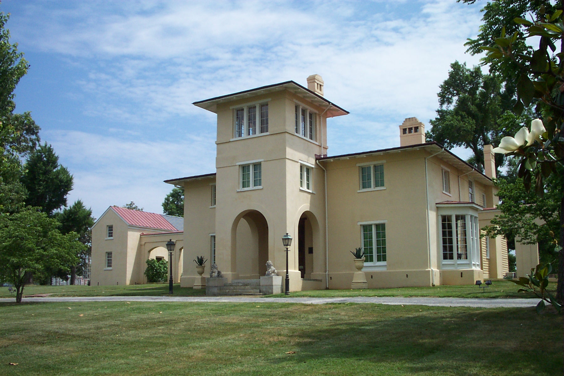
36°4′3″N 79°46′47″W / 36.0675°N 79.77972°WGreensboro 7 Blandwood 
April 17, 1970 447 W. Washington St.
36°4′9″N 79°47′38″W / 36.06917°N 79.79389°WGreensboro 8 Buffalo Presbyterian Church and Cemetery September 16, 2002 800 and 803 Sixteenth St.
36°6′33″N 79°46′49″W / 36.10917°N 79.78028°WGreensboro 9 Bumpas-Troy House December 6, 1977 114 S. Mendenhall St.
36°4′20″N 79°48′12″W / 36.07222°N 79.80333°WGreensboro 10 David Caldwell Log College Site January 13, 1982 Address Restricted Greensboro 11 Wilbur and Martha Carter House August 13, 2008 1012 Country Club Dr.
36°5′55.63″N 79°48′32.43″W / 36.0987861°N 79.8090083°WGreensboro 12 Central Fire Station April 28, 1980 318 N. Greene St.
36°4′33″N 79°47′29″W / 36.07583°N 79.79139°WGreensboro 13 College Hill Historic District November 4, 1993 Roughly bounded by W. Market St., S. Cedar St., Oakland Ave. and McIver St.
36°4′8″N 79°48′12″W / 36.06889°N 79.80333°WGreensboro 14 Deep River Friends Meeting House and Cemetery December 13, 1995 5300 W. Wendover Ave.
36°1′53″N 79°57′55″W / 36.03139°N 79.96528°WHigh Point 15 Dixon-Leftwich-Murphy House September 23, 1982 507 Church St.
36°4′46″N 79°47′13″W / 36.07944°N 79.78694°WGreensboro 16 Downtown Greensboro Historic District June 17, 1982 Elm, S. Davie, S. Green, and E. and W. Washington Sts.
36°4′7″N 79°47′25″W / 36.06861°N 79.79028°WGreensboro 17 James Benson Dudley Senior High School and Gymnasium April 11, 2003 1200 Lincoln St.
36°3′35″N 79°45′54″W / 36.05972°N 79.765°WGreensboro 18 East White Oak School, Former April 21, 1992 1801 Tenth St.
36°6′4″N 79°45′37″W / 36.10111°N 79.76028°WGreensboro 19 Endsley-Morgan House October 25, 1984 Off U.S. 421
36°7′23″N 80°0′51″W / 36.12306°N 80.01417°WColfax 20 William Fields House December 5, 1985 447 Arlington St.
36°3′54″N 79°47′21″W / 36.065°N 79.78917°WGreensboro 21 First Baptist Church January 8, 2009 701 E. Washington Dr.
35°57′41.07″N 79°59′58.93″W / 35.9614083°N 79.9997028°WHigh Point 22 Fisher Park Historic District January 22, 1992 Roughly bounded by Fisher and Bessemer Aves. and Wharton and Church Sts.; also 507 N. Church St.
36°4′59″N 79°47′26″W / 36.08306°N 79.79056°WGreensboro 507 Church represents a boundary increase of September 12, 1996 23 Former Jamestown High School December 6, 1991 200 W. Main St.
35°59′36″N 79°56′21″W / 35.99333°N 79.93917°WJamestown 24 Former Charles D. McIver School April 3, 1992 617 W. Lee St.
36°3′47″N 79°48′4″W / 36.06306°N 79.80111°WGreensboro 25 Former Pomona High School February 24, 1995 221 Spring Garden St.
36°3′47″N 79°49′48″W / 36.06306°N 79.83°WGreensboro 26 Edward J. Forney House April 21, 1992 1402 Spring Garden St.
36°3′56″N 79°48′48″W / 36.06556°N 79.81333°WGreensboro 27 Daniel P. Foust House January 20, 2005 439 Brightwood Church Rd.
36°4′40″N 79°34′48″W / 36.07778°N 79.58°WWhitsett 28 Julius I. Foust Building September 11, 1980 1000 W. Spring Garden St.
36°4′1″N 79°48′29″W / 36.06694°N 79.80806°WGreensboro 29 Foust-Carpenter and Dean Dick Farms July 1, 2009 East and west sides of Mt. Hope Church Rd. and north and south sides of Carpenter House Rd.
36°1′26″N 79°37′53″W / 36.02389°N 79.63139°WWhitsett 30 John Marion Galloway House July 21, 1983 1007 N. Elm St.
36°5′11″N 79°47′24″W / 36.08639°N 79.79°WGreensboro 31 Gardner House October 15, 1974 E of Jamestown on SR 1383
35°59′19″N 79°53′28″W / 35.98861°N 79.89111°WJamestown 32 Dr. C. S. Grayson House March 17, 1994 1009 N. Main St.
35°58′5″N 80°0′55″W / 35.96806°N 80.01528°WHigh Point 33 Green Hill Cemetery Gatekeeper's House May 29, 1979 700 Battleground Ave.
36°4′47″N 79°47′43″W / 36.07972°N 79.79528°WGreensboro 34 Greensboro Historical Museum April 25, 1985 130 Summit Ave.
36°4′32″N 79°47′17″W / 36.07556°N 79.78806°WGreensboro 35 Greensboro Senior High School September 7, 2005 801 Westover Terrace
36°5′2″N 79°48′57″W / 36.08389°N 79.81583°WGreensboro 36 Guilford College 
June 21, 1990 5800 W. Friendly Ave.
36°5′40″N 79°52′58″W / 36.09444°N 79.88278°WGreensboro Boundaries slightly decreased on June 27, 2001 37 Guilford County Courthouse May 10, 1979 Market St.
36°4′20″N 79°47′34″W / 36.07222°N 79.79278°WGreensboro 38 Guilford County Office and Court Building December 20, 1988 258 S. Main St.
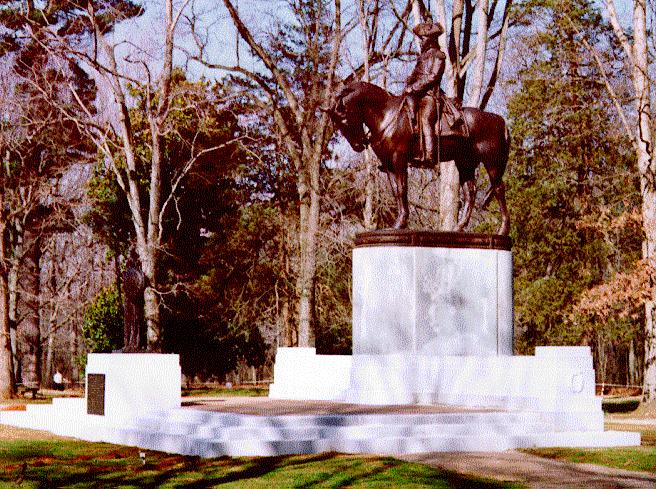
35°57′14″N 80°0′20″W / 35.95389°N 80.00556°WHigh Point 39 Guilford Courthouse National Military Park 
October 15, 1966 Address Restricted Greensboro 40 Guilford Mill August 2, 1982 SE of Oak Ridge on NC 68
36°9′38″N 79°58′41″W / 36.16056°N 79.97806°WOak Ridge 41 John Haley House August 26, 1971 1805 E. Lexington Ave.
35°58′49″N 79°59′42″W / 35.98028°N 79.995°WHigh Point 42 Hardee Apartments March 14, 1991 1102 N. Main St.
35°58′9″N 80°0′54″W / 35.96917°N 80.015°WHigh Point 43 Hillsdale Brick Store June 14, 1982 NC 150 and SR 2347
36°11′59.99″N 79°50′38.73″W / 36.1999972°N 79.8440917°WHillsdale 44 Hillside February 1, 1980 301 Fisher Park Circle
36°4′32″N 79°47′34″W / 36.07556°N 79.79278°WGreensboro 45 Holly Gate September 22, 1980 NC 61
36°4′18″N 79°33′50″W / 36.07167°N 79.56389°WWhitsett 46 Hoskins House Historic District March 15, 1988 Intersection of New Garden Rd. and US 220
36°8′19″N 79°51′10″W / 36.13861°N 79.85278°WGreensboro 47 Charles H. Ireland House May 29, 1979 602 W. Friendly Ave.
36°4′26″N 79°47′51″W / 36.07389°N 79.7975°WGreensboro 48 Irving Park Historic District February 21, 1995 Roughly bounded by Buffalo Cr., Battleground Ave., Cornwallis Dr. and W. Northwood St.
36°5′47″N 79°47′54″W / 36.09639°N 79.79833°WGreensboro 49 Jamestown Historic District January 22, 1973 Both sides of U.S. 29A
35°59′40″N 79°56′44″W / 35.99444°N 79.94556°WJamestown 50 Jefferson Standard Building May 28, 1976 Elm and Market Sts.
36°4′22″N 79°47′32″W / 36.07278°N 79.79222°WGreensboro 51 Kellenberger Estate March 17, 1994 1415 Kellenberger Rd.
36°3′13″N 79°40′19″W / 36.05361°N 79.67194°WGreensboro 52 Kilby Hotel April 22, 1982 627 E. Washington St.
35°57′40″N 80°0′2″W / 35.96111°N 80.00056°WHigh Point 53 Kimrey-Haworth House March 14, 1991 5307 W. Friendly Ave.
36°5′20″N 79°52′43″W / 36.08889°N 79.87861°WGreensboro 54 O. Arthur Kirkman House and Outbuildings January 28, 1988 501 W. High St.; also 106 Oak St.
35°57′13″N 80°0′42″W / 35.95361°N 80.01167°WHigh Point 106 Oak represents a boundary increase of June 9, 1989 55 Latham-Baker House November 12, 1982 412 Fisher Park Circle
36°4′56″N 79°47′30″W / 36.08222°N 79.79167°WGreensboro 56 Low House March 8, 1978 S of Gibsonville
36°2′59″N 79°34′13″W / 36.04972°N 79.57028°WWhitsett 57 Lyndon Street Townhouses April 3, 1992 195-201 Lyndon St.
36°4′16″N 79°47′7″W / 36.07111°N 79.78528°WGreensboro 58 Harden Thomas Martin House December 19, 1985 204 N. Mendenhall St.
36°4′28″N 79°48′9″W / 36.07444°N 79.8025°WGreensboro 59 McCulloch's Gold Mill 
April 24, 1979 Address Restricted Jamestown 60 Dr. Joseph A. McLean House February 2, 1995 U.S. 70 north side, 0.1 miles west of junction with NC 3053
36°4′15″N 79°37′54″W / 36.07083°N 79.63167°WSedalia 61 Richard Mendenhall Plantation Buildings November 3, 1972 U.S. 29
35°59′34″N 79°56′56″W / 35.99278°N 79.94889°WJamestown 62 Mock, Judson, Voehringer Company Hosiery Mill March 28, 2011 2610 Oakland Ave.
36°3′43″N 79°50′7″W / 36.06194°N 79.83528°WGreensboro Textile mill built between 1927 and 1938[5] 63 Model Farm April 20, 2011 2058 Brentwood St.
35°56′17″N 79°58′42″W / 35.93806°N 79.97833°WHigh Point 64 Oak Ridge Military Academy Historic District March 17, 1983 NC 150 and NC 68
36°10′32″N 79°59′13″W / 36.17556°N 79.98694°WOak Ridge 65 Oakdale Cotton Mill Village March 15, 1976 SR 1352 and SR 1144
35°58′50″N 79°55′48″W / 35.98056°N 79.93°WJamestown 66 Oakwood Historic District February 7, 1991 100-300 blocks Oakwood St.
35°57′22″N 80°0′48″W / 35.95611°N 80.01333°WHigh Point 67 Palmer Memorial Institute Historic District October 24, 1988 Along US 70 W of jct. with NC 3056
36°4′2″N 79°37′25″W / 36.06722°N 79.62361°WSedalia 68 William Penn High School November 16, 1978 Washington Dr.
35°57′43″N 79°59′51″W / 35.96194°N 79.9975°WHigh Point 69 Ragsdale Farm September 3, 1991 404 E. Main St.
35°59′48″N 79°55′51″W / 35.99667°N 79.93083°WJamestown 70 Revolution Cotton Mills March 1, 1984 Roughly bounded by Southern RR, N. Buffalo Creek, Yanceyville and 9th Sts.
36°5′57″N 79°46′42″W / 36.09917°N 79.77833°WGreensboro 71 L. Richardson Memorial Hospital, Former April 3, 1992 603 S. Benbow Rd.
36°4′4″N 79°46′14″W / 36.06778°N 79.77056°WGreensboro 72 Thomas Scott House July 12, 1984 SR 1001
36°10′6″N 79°47′28″W / 36.16833°N 79.79111°WGreensboro 73 Shaw-Cude House June 1, 1982 Off SR 2010
36°7′26″N 79°59′0″W / 36.12389°N 79.983333°WColfax 74 Sherrod Park March 14, 1991 200-300 blocks Woodrow Ave.
35°58′8″N 80°0′28″W / 35.96889°N 80.00778°WHigh Point 75 Michael Sherwood House January 31, 1978 426 W. Friendly Ave.
36°4′26″N 79°47′43″W / 36.07389°N 79.79528°WGreensboro 76 J. C. Siceloff House March 14, 1991 1104 N. Main St.
35°58′9″N 80°0′55″W / 35.96917°N 80.01528°WHigh Point 77 Francis Marion Smith House July 12, 1984 204 Railroad Ave.
36°6′15″N 79°32′28″W / 36.10417°N 79.54111°WGibsonville 78 William Rankin and Elizabeth Wharton Smith House February 27, 2007 437 Brightwood Church Rd., NC 2758, 0.62 miles N of US 70
36°4′44″N 79°34′51″W / 36.07889°N 79.58083°WWhitsett 79 South Greensboro Historic District December 20, 1991 Roughly bounded by Gorrell, Martin, E. Bragg, Sevier, Omaha, Broad, Caldwell, Andrew, Vance, McCulloch, and King Dr.
36°3′40″N 79°47′6″W / 36.06111°N 79.785°WGreensboro 80 Sigmund Sternberger House April 16, 1993 712 Summit Ave.
36°4′52″N 79°46′44″W / 36.08111°N 79.77889°WGreensboro 81 Summerfield Historic District May 18, 2005 4105-4210 Oak Ridge Rd. and 7702-7804 Summerfield Rd.
36°12′25″N 79°54′21″W / 36.20694°N 79.90583°WSummerfield 82 Summit Avenue Historic District August 5, 1993 Roughly bounded by Chestnut, E. Bessemer, Cypress, Dewey, Park, and Percy Sts.
36°4′54″N 79°46′55″W / 36.08167°N 79.78194°WGreensboro 83 Tabernacle Methodist Protestant Church and Cemetery March 10, 1995 5601 Liberty Rd.
35°57′55″N 79°41′49″W / 35.96528°N 79.69694°WGreensboro 84 A. E. Taplin Apartment Building March 1, 1996 408 W. Parkway Ave.
35°58′3″N 80°1′11″W / 35.9675°N 80.01972°WHigh Point 85 Tomlinson Chair Manufacturing Company Complex March 17, 1983 305 W. High St.
35°57′18″N 80°0′33″W / 35.955°N 80.00917°WHigh Point 86 Union Cemetery October 21, 1993 900 blook S. Elm St.
36°3′31″N 79°47′29″W / 36.05861°N 79.79139°WGreensboro 87 Wadsworth Congregational Church December 31, 2002 1301 Rock Creek Dairy Rd.
36°2′49″N 79°35′52″W / 36.04694°N 79.59778°WWhitsett 88 Wafco Mills May 30, 1979 801 McGee St.
36°4′7″N 79°47′56″W / 36.06861°N 79.79889°WGreensboro 89 Simeon Wagoner House September 3, 1991 5838 NC 61 (Friedens Church Rd.)
36°7′31″N 79°33′31″W / 36.12528°N 79.55861°WGibsonville 90 Washington Street Historic District December 28, 2010 Portions of eight blocks on Washington, Centennial, Fourth, and Hobson Sts., Eccles Pl., and Gaylord Ct.
35°57′40″N 80°0′8″W / 35.96111°N 80.00222°WHigh Point 91 Dr. David P. Weir House July 12, 1984 223 N. Edgeworth St.
36°4′28″N 79°47′48″W / 36.07444°N 79.79667°WGreensboro 92 West High Street Historic District April 12, 2007 407,409,415,501,503 and 507 W. High St., 106,107 and 110 Oak St.
35°57′20″N 80°0′41″W / 35.95556°N 80.01139°WHigh Point 93 West Market Street Methodist Episcopal Church, South December 19, 1985 302 W. Market St.
36°4′25″N 79°47′36″W / 36.07361°N 79.79333°WGreensboro 94 White Oak New Town Historic District April 3, 1992 2400-2418 N. Church, 2312-2509 Spruce, 2310-2503 Hubbard and 2401-2503 Cypress Sts.
36°6′23″N 79°46′45″W / 36.10639°N 79.77917°WGreensboro 95 Whitsett Historic District May 5, 1999 Jct. NC 61 and NC 3064
36°4′6″N 79°33′49″W / 36.06833°N 79.56361°WWhitsett 96 Lucy and J. Vassie Wilson House May 4, 2005 425 Hillcrest Dr.
35°58′26″N 80°1′39″W / 35.97389°N 80.0275°WHigh Point 97 World War Memorial Stadium 
April 12, 2001 510 Yanceyville St.
36°4′47″N 79°46′38″W / 36.07972°N 79.77722°WGreensboro See also
- National Register of Historic Places listings in North Carolina
- List of National Historic Landmarks in North Carolina
References
- ^ The latitude and longitude information provided in this table was derived originally from the National Register Information System, which has been found to be fairly accurate for about 99% of listings. For about 1% of NRIS original coordinates, experience has shown that one or both coordinates are typos or otherwise extremely far off; some corrections may have been made. A more subtle problem causes many locations to be off by up to 150 yards, depending on location in the country: most NRIS coordinates were derived from tracing out latitude and longitudes off of USGS topographical quadrant maps created under North American Datum of 1927, which differs from the current, highly accurate GPS system used by Google maps. Chicago is about right, but NRIS longitudes in Washington are higher by about 4.5 seconds, and are lower by about 2.0 seconds in Maine. Latitudes differ by about 1.0 second in Florida. Some locations in this table may have been corrected to current GPS standards.
- ^ "National Register of Historic Places: Weekly List Actions". National Park Service, United States Department of the Interior. Retrieved on November 10, 2011.
- ^ Numbers represent an ordering by significant words. Various colorings, defined here, differentiate National Historic Landmark sites and National Register of Historic Places Districts from other NRHP buildings, structures, sites or objects.
- ^ "National Register Information System". National Register of Historic Places. National Park Service. 2008-04-24. http://nrhp.focus.nps.gov/natreg/docs/All_Data.html.
- ^ "MoJud Mill Considered For Mixed-Use Preservation Project". Greensboro, North Carolina: Preservation Greensboro. May 18, 2010. http://preservationgreensboro.typepad.com/weblog/greensboro_preservation_news/. Retrieved April 14, 2011.
U.S. National Register of Historic Places Topics Lists by states Alabama • Alaska • Arizona • Arkansas • California • Colorado • Connecticut • Delaware • Florida • Georgia • Hawaii • Idaho • Illinois • Indiana • Iowa • Kansas • Kentucky • Louisiana • Maine • Maryland • Massachusetts • Michigan • Minnesota • Mississippi • Missouri • Montana • Nebraska • Nevada • New Hampshire • New Jersey • New Mexico • New York • North Carolina • North Dakota • Ohio • Oklahoma • Oregon • Pennsylvania • Rhode Island • South Carolina • South Dakota • Tennessee • Texas • Utah • Vermont • Virginia • Washington • West Virginia • Wisconsin • WyomingLists by territories Lists by associated states Other  Category:National Register of Historic Places •
  Portal:National Register of Historic Places
Municipalities and communities of Guilford County, North Carolina County seat: Greensboro Cities Archdale‡ | Burlington‡ | Greensboro | High Point‡
Towns Gibsonville‡ | Jamestown | Kernersville‡ | Oak Ridge | Pleasant Garden | Sedalia | Stokesdale | Summerfield | Whitsett
CDPs Unincorporated
communitiesBrowns Summit | Climax | Colfax | Julian | Monticello
Footnotes ‡This populated place also has portions in an adjacent county or counties
Categories:- Guilford County, North Carolina
- National Register of Historic Places in North Carolina
- Buildings and structures in Guilford County, North Carolina
-


Wikimedia Foundation. 2010.